--- Archive files ---
Home > Travels > Titicaca > 10 |
Across Arid Wasteland to the City in the Sky
HAVING crossed the narrowest part of the world’s highest lake at Tiquina, the bus gradually climbed the hill, getting higher and higher. The sky was bright blue in contrast to the yellow green grass and the yellowish grey granite of the exposed rocky outcrops. The hills were rounded but otherwise this was quite a desolate area, approaching the start of the Atacama Desert – the driest place on Earth.
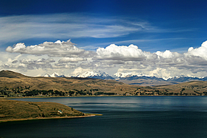
Last view of Lake Titicaca |
All we saw up here were buses and road snaking up the hills. There were few grazing animals and very few houses. We climbed and climbed and climbed until reaching around four thousand two metres above sea level. From here we had spectacular views over the pristine dark blue lake in the void between the ranges of hills.
The winding nature of the ridges that the road followed didn’t seem to give any impression of us actually getting anywhere with taking such a round about way over the mountains. At some stage though I realised we were starting to descend the other side. Eventually we reached the bottom of the hills at the start of a small plain.
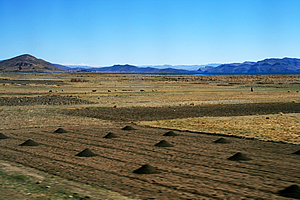
Arid farmland at the edge of the Atacama Desert |
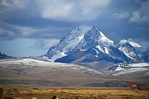
We crossed over the narrow plain towards a set of low hills. On the other side of the hills was a range of spectacular mountains carved by glaciers into huge blocks and covered in snow. These were part of the main divide of the Andes, towering to over six thousand metres above sea level, although from here on the plain they were only two to two and a half kilometres higher than us.
The road tracked across the very dry grassy plain. The lake was completely out of sight. It was very desolate out here with only the snow covered pinnacles and otherwise very dry farmland. The lake is supposed to drain out around this area only through a small river running into a much smaller lake from where the water completely evaporates. Despite being so arid here, the grassland had the occasional derelict house made from mud brick along the side of the road. Around each house low mud brick walls marked the boundaries of paddocks where people were working in the dry dust here at the edge of the Atacama Desert.
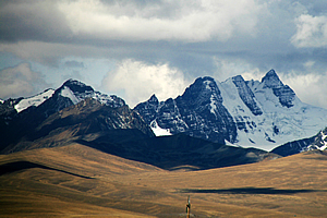
The Andes towering over 6km high |
The Atacama Desert is the driest place on earth. Some parts of the desert have not seen any rain for over four hundred years. At this end of the desert though, there was still enough rainfall for crops to briefly grow during the short summer growing season. It must be a very tough existence trying to earn a living.
The mountains were out of the other side of the bus from where I was sitting, so it was hard to get good pictures. I was therefore happy when we stopped at a petrol station for the driver to fill the bus with petrol and for us tourists to buy snacks. Unfortunately there was a very high stone wall behind the petrol station denying me the view I needed to photograph these wonders.
Fresh snow from yesterday's storm |
Knowing we were getting pretty close to La Paz, I decided not to buy anything here. I’ll save my new Bolivianos for later.
The bus took off from the petrol station and we continued along the very dry grassy plains passing the giant snow covered mountains distant to our right. There was no distinct boundary to the marking the start of the city, but at some stage I noticed the concentration of housing beginning to increase.
El Alto - the world's highest city |
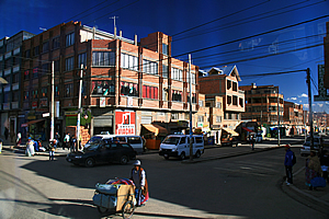
About twenty minutes after leaving the petrol station we passed through a derelict town centre with three storey buildings. I assumed this wouldn’t go for much longer, but soon we were passing through a large residential area. There were a lot of people here and the buildings seemed to be constructed of an extremely poor standard. It seemed to be a very poor area to live in compared to the relative wealth of the other parts of Bolivia I had seen earlier today.
This was El Alto, the world’s highest city with an average elevation of 4150 metres above sea level. It is also one of the world’s poorest. The population here is mostly indigenous Aymara people with about 10% Quechua.
Soon the traffic became heavy and it was pretty hard to make any progress at all. We reached a large roundabout with the road to the left heading off to the airport. I will be going there in a few days time to fly down to Santiago.
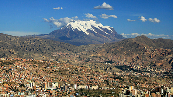
La Paz |
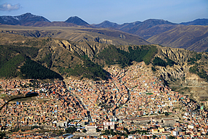
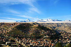
About a kilometre past the turnoff to the airport the road suddenly swung around and started descending, abruptly leaving the city. I looked out the window into a five hundred metre deep basin tightly containing La Paz, Bolivia’s capital city. It was an amazing view with the high rise buildings of the central business district at the bottom of the basin, apartment blocks and houses on the sides of the basin, then the desolate plain above and the towering mountains above the plain.
The plain to the right was covered with a recently laid layer of snow. There must be a ski field up there. We continued our descent along the highway going around the rim of the giant bowl gradually heading downhill. I got some pretty good shots of the city from up there.
La Paz |
Finally we were in the city centre, with the bottom of the bowl sloping quite steeply downwards. The bus finally stopped at the side of the road under a highway overpass to let our group out in the middle of the noisy city.
There were quite a lot of large high rise buildings in the city centre. The hills surrounding the city were covered in terracotta coloured brick residential buildings sweeping their way up the hill to a high ridge. The buildings towards the top seemed to be precariously perched. Hopefully there wasn’t going to be a big earthquake here any time soon.
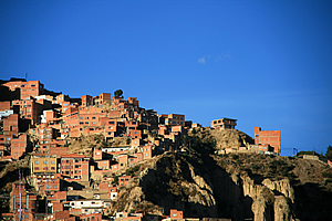
La Paz |
Most of the others in my group wanted to go to a night club. Carlos knew of a few around here. I didn’t think that would be particularly safe. I was very tired anyway as were Michael and Julia. We parted ways and those of us catching a taxi back to the hotel. I sat in the front seat of the taxi. From here I could see out into the dim streets where we closely followed a car that had a small piece of polystyrene tied a piece of string with the other end tied about a metre and a half away at the tow bar. I had no idea what that was about (perhaps it was a deterrent from getting rear ended), but our driver followed the old car tooting his horn for quite a while as the polystyrene just bounced around on the road in front of us as it was being pulled along.
Eventually though we turned off and went around a dark block of narrow and steep alleys before pulling up outside the hotel, ready for an early night before continuing my travels through South America.
<< Previous | Next >> |
|
||
About this Page
|
||
|
|
|
Where is Walkabout Jeff? |
|
|

|
|
What is happening in Walkabout Jeff's hometown?
|
|
|

|
|
Who is Walkabout Jeff?Any normal person's idea of going out involves going to the local pub for a drink with a few mates. Walkabout Jeff isn't normal.
|
|
|

|
Follow Walkabout Jeff |
|