--- Archive files ---
Home > Treks > Gorillas > 1.1 |
Rocky Mountain Road over Stolen Habitat
I HAD been travelling westward from Kampala for several days now. Until now the road across Uganda had been in good condition, but now the western border to Rwanda and the Democratic Republic of Congo was near, it was obvious we were heading into remote territory.
Kabale |
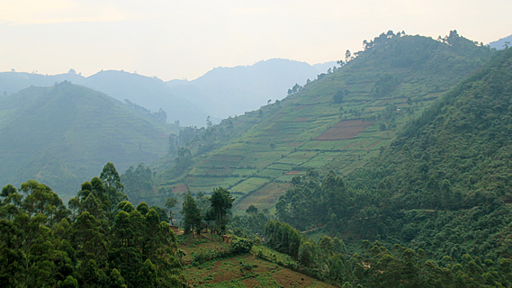
Upon leaving the small dusty city of Kabale we followed the main road along the bottom of the wide valley before turning off to the left. This road quickly departed the valley and started ascending into the mountains. The rolling hills of fields of tea quickly gave way to steeper rounded mountains with hedged terraces of small fields spreading out in an enormous patchwork over the mountains. The terraces roughly followed the contours of the mountains. Small houses with bright shiny corrugated iron roofing dotted these mountains randomly spread from their summits down to the valley below.
The road tightly wound around the mountains negotiating passes and valleys galore. In between the passes the road mostly clung precariously to the sides of the mountains. The houses we did pass close by were dirty looking mud brick houses mostly with people sitting or standing outside of them. Most were perched on the ridges. Perhaps this was because there was less chance of them being affected by erosion than in the gullies. Many people were walking along the road, some herding small flocks of animals. Most were carrying baskets of produce on their heads. There were no other vehicles on the precarious road.
Rugged farmland |
Eventually we turned off the main road onto a narrow gravel road which continued winding around the mountains. The road was quite rough – African massage material. It was rather narrow forcing us to be precariously close to the steep drop below us. The road wound around going continuously uphill never reaching the tops of the increasingly high mountains with rounded summits.
The main valleys below us were either steep gorges or lakes. Perhaps the lakes had been blocked by large landslides.
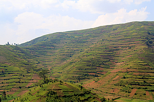
Most of the mountainsides were covered in the small terraced paddocks where vegetables grew. It was evident though that until fairly recently this had all once been forest. There were numerous slips that had come down on the road in storms past, but fortunately these had all been cleared. The only thing holding these vegetable plots onto the sides of the mountains were wooden fences that had over the years sprouted into trees. Some of these fences were almost new and only had the first shoots sprouting off them. Others were now rows of trees that had grown to around ten metres tall. These tree fences lined each side of the road to minimise erosion, but it was clear the slopes of these mountains were very unstable.
Vegetable fields |
Occasionally we encountered a cow wandering along the road. Perhaps it was there deliberately to keep the grass of the verges down, or maybe it had escaped the confines of its paddock.
A car overtook us. This was the first car we had encountered on this narrow road. Our driver Jeremiah had to pull over to let them pass. For the following ten minutes we were choking on the dust the back wheels were kicking up before it got too far ahead to be of any problem to us anymore.
The mountains were somewhat obscured by a thin haze washing much of the colour out of them. The rounded mountains towered high to around three thousand metres. We were getting close to the main dividing range now, the boundary between Uganda and the Democratic Republic of Congo.
We continued passing numerous houses along the sides of the road, each house perched against the edge of the mountains ready to slip away at the next big storm. There were a lot of people around the houses, and groups of grubby children waved out to us, many yelling “hello”, and some yelling “money”. Some ridges or gullies had entire villages of tiny dilapidated houses clustered close together.
As we travelled further and further along the road, the quality of the houses continued to decline to appalling standards, and yet everyone we passed seemed happy. Most people were dressed in rags, though some of the women wore very nice dresses and the occasional man wore a suit – albeit worse for wear.
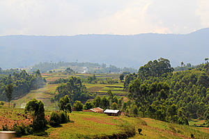
We had climbed to almost three thousand metres above sea level when the road finally topped out and began to descend. By now there were clear views of many mountains, though all were still very rounded on top. Many of these mountains were now forested, indicating we were close to our destination. Even the hills that weren’t forested had large trees on them indicating the forest had recently covered them. The road steeply descended to a bridge over a small river. We must be near the head of the valley and therefore close to the border.
We had reached the Bwindi Impenetrable Forest.
Once across the narrow bridge, the road steeply climbed uphill. The quality of the road was even less than before and the mountainsides steeper than ever. Most of these mountainsides still had small plots of vegetables growing on them, but how they managed to stayed there defied gravity.
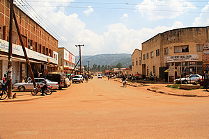
Cliffs were appearing along the sides of the mountains now, but somehow the vegetable plots came almost up to them. We went higher and higher around precipitous ridge and gully, before briefly descending into a small village – the last outpost in the most remote corner of Uganda.
The village was a dirt road with numerous derelict shops lining each side of the street. As we continued further, some of the shops appeared quite new, though still traditionally constructed. Then we suddenly turned off onto a short driveway past a couple of houses to the Wagtail Eco Safari Camp, where we will be based for the next three nights.
<< Previous | Next >> |
|
||
About this Page
|
||
|
|
|
Where is Walkabout Jeff? |
|
|

|
|
What is happening in Walkabout Jeff's hometown?
|
|
|

|
|
Who is Walkabout Jeff?Any normal person's idea of going out involves going to the local pub for a drink with a few mates. Walkabout Jeff isn't normal.
|
|
|

|
Follow Walkabout Jeff |
|