--- Archive files ---
Home > Treks > Kilimanjaro > Day 3 > 3.2 |
Polé Polé!
I RECALLED from past high altitude treks that the best way to acclimatise on a climb was to ascend slowly. This has been the case last night at the briefing for the climb that was going to be by far my highest.
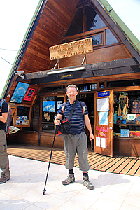
About ten minutes after leaving the Marangu Hotel following the narrow winding road up the mountain, we reached a large car park where the van stopped. We piled out carrying our bags with us across the car park to a low set of stairs at the base of a wooden platform with a couple of large two storey A-framed wooden buildings.
At the park entrance |
We signed in at the larger A-framed building. It was definitely a chalet style building reminding me of my own house back in Brisbane. It took quite a while for us all to be signed in though, signing away our names, leaders and passport numbers. Two local men were behind the counter, one taking our passports and photocopying them and the other making sure we were filling in the intentions book.
I was one of the first to sign in, so spent the time whilst waiting setting my walking pole to an optimum height for the long uphill ahead – all three and a half days of uphill covering 3925 metres of altitude gain before I would need to lengthen the pole at the summit for the long descent.
I waited in nervous anticipation for the others to sign in. To me this was like doing Mount Kinabalu last year, venturing into new altitudes. This time though I was heading into very dangerously high altitude.
Once we were all signed in, we walked a few metres to a small service road where there was a large sign indicating the different legs of the trail.
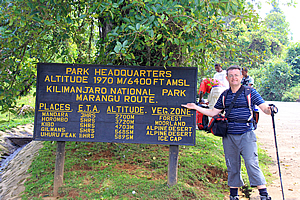
A long way to go... |
There is an urban legend that the Marangu Route is said to be the easy way up the mountain. Perhaps it is because this route sees more people than the other four routes put together. Perhaps it is because it is the only route where there are huts to stay in every night. Perhaps it is because it is the only route where you are allowed to complete the entire trek in five days.
For whatever reason it is considered the easy route, it also has the highest failure rate. Despite the urban legend, this route is technically just as difficult as any other route. This is also the only route where groups complete it in five days. For those of us doing it in the short five days, it is actually more dangerous due to the lack of time you get to acclimatise to the thinning air.
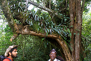
Epiphytes growing on a tree |
Des had mentioned all of this at the briefing last night, but now it was starting to sink in. Here I was at the base of the world’s tallest free standing mountain, one of the seven summits, and the fifth most prominent mountain the world, about to venture into unknown altitudes on the route and itinerary with the highest failure rate.
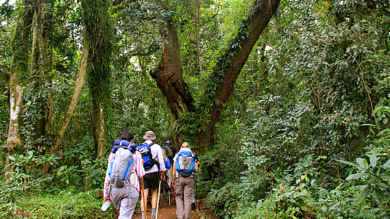
We all posed beside the sign for photos for a few minutes before Jaseri led us through a small open gate to the start of the track. We all followed him, with the two assistant guides wearing their backpacks at the rear. The road was for the porters and any service vehicles heading up the mountain.
Jaseri led the way wearing his woollen hat, with Vicky directly behind and Gary and Dawn behind them. I was next with Ashley following me and the Canadian Indians behind her. Jono was wearing a cowboy hat and to my surprise he was spitting on a very regular basis. At the back of the group were our assistant guides Azaan and Imara each carrying a fairly sizable backpack. We commenced the epic hike walking at a very slow pace. Jaseri deliberately set the pace telling us every five minute “polé polé” (pronounced pollay pollay). I remembered from last night’s briefing that a slow ascent was essential in minimising the symptoms of altitude sickness.
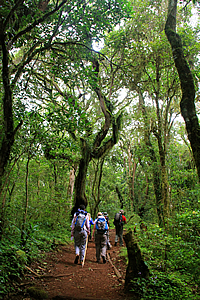
Walking through the forest |
Walking through the forest |
I recalled we had the same thing at the start of Mount Kinabalu. Though rather than polé polé it was pelan pelan. In whatever language, it was universally accepted that high mountains required respect by ascending slowly, slowly. Anyway I was happy to oblige at Jaseri’s pace although I think the others thought he was taking it too slowly.
My legs suddenly felt surprisingly stiff as we passed through the thick forest. Then I realised the stiffness was from the intense walk up and down the gully from the waterfall yesterday. The stiffness was quickly starting to increase. Although I had a fitness trainer over the past year and a half, I had stopped going about a month earlier when I had accidentally put my back out a little My back had quickly recovered, but I never picked my fitness routine up again in fear of any further injury. I was now paying for that decision.
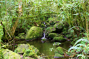
Small cascading stream |
I was very careful to let my back rest for about two weeks before the start of the trip. Unfortunately during that time my fitness had decreased significantly and my weight had suddenly increased. Since arriving in Africa I had been eating a lot more than usual adding to the weight I was putting on. Now I had nowhere near the fitness that I had last year when I had done the Inca Trail or Mount Kinabalu.
Additional to this my new boots felt a little stiff. My old ones had worn out from my past trips, so I had bought some more of the same size. Well I had thought they were the same size. Now it seemed that these were slightly smaller than the other pair. Hopefully they weren’t going to cause me any discomfort when it really mattered.
Despite these minor ailments I still had the willpower to get to the top.
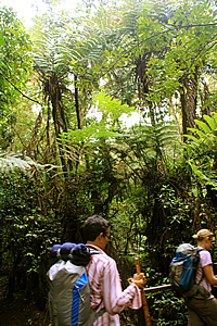
We plodded on saying polé polé. Now we were hiking through the amazing cloud forest, with gnarled trees with orange bark mostly covered in moss and epiphytic ferns. The trunks of the trees were smothered with broadleaf climbing plants growing up them.
There were a lot of tiny flowers beside the track. There were tiny white bell flowers and little violets of several colours from white to purple. The track started a gentle rise roughly following the top of a low ridge. The trees became taller and very magnificent with the occasional grove of tree ferns.
We crossed a small wooden bridge over a small stream full of pools surrounded by moss covered rocks under large tree ferns. This was quickly followed by a boardwalk to a small junction, where Jaseri led us along the side track to the right.
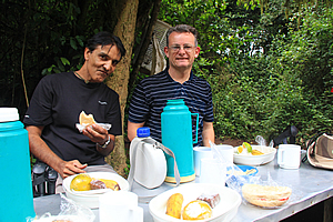
Lunch! |
The side track crossed a small bridge before turning and rising to the service road. Here we would have been about two thousand metres above sea level. We crossed over the dirt road to a large aluminium picnic table where we had lunch. Many porters were walking in either direction along the road, along with the occasional service vehicle slowly driving past. Most of the porters were carrying their sacks of gear on their heads. Even the ones wearing backpacks were carrying them on their heads. To me it seemed completely weird, but they all seemed reasonably comfortable. Perhaps their skulls are thicker than ours.
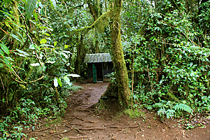
Loos hidden in the forest |
Behind us nestled deep in the thick forest was a crude toilet block, which I used. In front of it were several sacks hanging off the trees for us to put our rubbish in, and no doubt for porters to carry down the mountain.
I pulled out the lunch box that Jaseri had given us this morning. The oranges were green and rather inedible I thought. Obviously they like them sour here. The sandwiches were nice though.
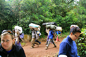
Porters passing us at lunch |
Once rested with lunch eaten we returned down the short trail to the main track, with a sign saying that Mandara was about an hour and a half away. We must be more than half way up there already, though the track became steeper from here onwards. My legs were feeling stiff again still recovering from yesterday’s climb into and out of the waterfall.
As soon as we entered the forest, we saw a couple of monkeys lurking deep in the forest. I didn’t get a good picture of them though as it was quite dark in there and the monkeys were very concealed keeping their distance from the strange travellers in their midst. The one that I did see had a very flat face with a white patch over its nose and mouth and chin. Otherwise it was a mousy grey colour. We saw another one in the trees in the distance. I think it was the same variety. This one had a very long white bushy tail.
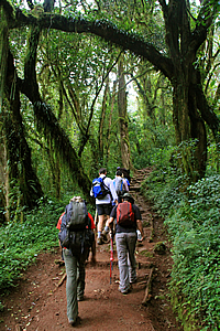
Continuing through the forest |
The undergrowth changed to a ferny cover. There was a small waterfall through the trees. The trees themselves were now covered in Spanish moss and starting to get smaller with approaching the bush line. We passed another entrance to the end of the service road, so now we were sharing the track with the porters. That being said all of our porters had well and truly passed us by now. The ones who were passing us were belonged to groups who would have departed the Marangu gate much later than our group. One thing these porters had in common was they clearly had no concept of polé polé. Then again they weren't going all the way to the summit, so the ascent wasn't going to be as extreme.
I had a clear goal of going all the way to the summit. I wasn't taking any chances. To survive this climb I was more than happy to go polé polé!
<< Previous | Next >> |
|
||
About this Page
|
||
|
|
|
Where is Walkabout Jeff? |
|
|

|
|
What is happening in Walkabout Jeff's hometown?
|
|
|

|
|
Who is Walkabout Jeff?Any normal person's idea of going out involves going to the local pub for a drink with a few mates. Walkabout Jeff isn't normal.
|
|
|

|
Follow Walkabout Jeff |
|