--- Archive files ---
Home > Treks > Kilimanjaro > Day 6 > 6.4 |
Following the Crater Rim
IT WAS still totally dark but I knew the sun will be rising soon. We needed our headlamps to see through the darkness which prevented a full appreciation of how bright the stars and moon would have been above us.
It seemed we were walking in the inside of the crater, negotiating the well-worn track around precipitous bluffs in the almost total darkness. Aside from the crunching sound of my boots on the frozen gravel, and the sounds of other people’s boots as they shuffled onwards towards the summit, it was totally silent up there. There was not a breath of wind, and as expected, there were no animals.
At this altitude the air would have been almost sterile. Without any plant or animal life up here there was nothing to pollute the air.
First light at 5700m |
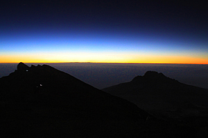
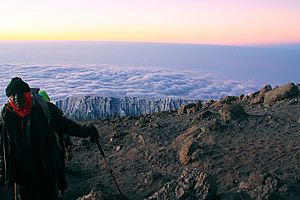
The sky started to lighten at about 5:50 AM, almost six hours out from our base camp at Kibo. The sky quickly brightened to a thin band of bright yellow with a thin orange line on the horizon. Further above that was a thin blue band which quickly morphed into the black sky.
At lower altitudes, the sky would turn a grey colour, then eventually purple, but up here it was quite bright along the horizon, highlighting the craggy bluffs of the crater, where the little glow-worm like lights of the other travellers behind me were inching their way towards the summit. The bright sky would have been a good eight or nine hundred kilometres away, so it will still be some time before the brightness would reach this part of the sky.
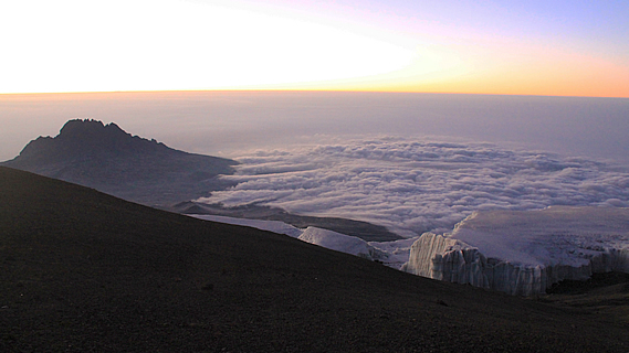
Further in the distance was Mawenzi Peak now a long way below us. The mighty mountain peak that had towered precipitously over us yesterday morning as we took the upper route from Horombo now seemed very small and far below us. I would never have thought about saying that about a massive jagged mountain peak standing over five kilometres high.
The going was very slow now. Up here at about five thousand seven hundred metres above sea level, the air was only half the density of that at sea level. I struggled to breathe the vacuous air. It was incredibly thin and also bone dry.
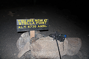
Stella Point |
We stumbled over another bluff and dropped a few metres to where I saw a sign. It read “You are now at Stella Point, Alt 5730 AMSL”. This marked the end of a couple of the other routes up the mountain – the Machame route and Lemosho route. Here other climbers would reach the crater after their arduous climb up the mountain and continue onto the summit. It was now 6:15 AM. To the west it was still dark, but the eastern sky was significantly bright.
I stopped here with my guide Imara to rest. Taking photos wearing gloves over mittens was virtually impossible, so I had to take off the climbing gloves to take the picture and put them down on one of the two rocks where the sign was wedged in between.
Stella Point was named after a climber in the late 1800s who climbed the nearby rock which towered into a peak. He had summited this peak thinking it was the top of Kilimanjaro only to much later discover it wasn’t the highest peak. With the real summit in my sights now, nothing was going to stop me from reaching the top.
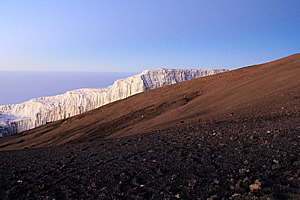
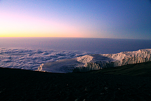
Glacial remnant of 11,000 year old ice cap |
Looking back, the sky behind me was quite a lot brighter although it was still completely dark in front. For the first time though, I could see the rocks of the crater to the right starting to pick up some of the light of the rapidly brightening sky. Small patches of snow were highlighted over the purple brown rock.
From here I could see more climbers ahead of me following the route now on the outside of the crater. The slope going away from the crater was a twenty to thirty degree slope and the slope into the crater was almost a sheer drop.
Realising that my hands weren’t getting too cold, I pocketed my gloves.
Dawn over the glacier |
I continued from Stella Point noticing the sky very quickly brightened over a matter of minutes. Down the outside of the crater I could see the glaciers I had seen from Horombo yesterday morning. Only they were a lot closer now. There were two of them. The nearer one to the left down the otherwise dead scree slope was the Rebmann Glacier, named after the explorer who first reported the ice cap covering the summit in 1848. A little beyond Rebmann Glacier was Decken Glacier.
The two small Glaciers looked like something from the edge of the ice pack of Antarctica. The ice was a good ten to fifteen metres thick, but around the outside the walls were vertical. The ice at the base was around eleven thousand seven hundred years old. This would be where the sun would heat the rock below melting the retreating glacier.
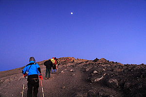
The moon shines bright over the summit |
During the 1800s the ice had covered the entire Kibo Peak. During the last ice age it had also covered the desert between Kibo and Mawenzi. The glaciers are rapidly retreating now with over eighty percent of the ice cover disappearing since 1912. It is believed the mountain will become completely ice free sometime between 2022 and 2033. I will be amongst the last of the climbers to see these glaciers.
Looking down beyond the glaciers a layer of purple grey cloud surrounded the mountain at about four thousand one hundred metres. It was the same soft patchy mid-level cloud I had seen over Chile when flying between Iquique and Santiago. However this cloud only surrounded the mountain. More than about fifty kilometres away there was no cloud in any direction. This was dawning a fine sunny day.
Jaseri climbing above the glaciers |
Behind me Mawenzi Peak towered above the cloud, and the large plateau we had walked across yesterday afternoon was above the surrounding cloud. The cloud surrounding the mountain looked like huge foamy waves breaking on an island beach. Beyond that was a soft grey haze which covered the plains spreading out five vertical kilometres below.
Although there was some distance to go to the summit, I already felt on top of the world.
<< Previous | Next >> |
|
||
About this Page
|
||
|
|
|
Where is Walkabout Jeff? |
|
|

|
|
What is happening in Walkabout Jeff's hometown?
|
|
|

|
|
Who is Walkabout Jeff?Any normal person's idea of going out involves going to the local pub for a drink with a few mates. Walkabout Jeff isn't normal.
|
|
|

|
Follow Walkabout Jeff |
|