--- Archive files ---
Home > Treks > Kilimanjaro > Day 6 > 6.6 |
It’s all Downhill from Here
I WAS only at the summit for nine or ten minutes. The rising sun would have already increased the temperature to about minus 8 degrees, but we needed to head down.
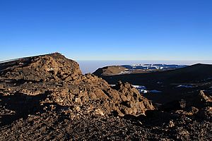
Final view of the summit |
For the first time in this trip, I started thinking of the downhill – From here there were nearly four vertical kilometres to drop to the start of the track at Marangu some forty eight kilometres away by tomorrow afternoon. Today, there is a drop of 2175 metres down to Horombo, something I just wasn’t looking forward to especially after such a long gruelling night climbing volcanic scree in sub-zero temperatures.
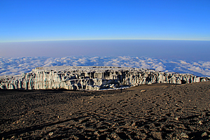
I left the top with my guide Imara, and with Gary, Dawn and Jaseri. Thankfully it was easy going down the gravely summit towards Stella Point. By now it was light enough for the glaciers to stand out brilliantly in the sunlight.
Glacier |
The moon was still high behind me, but it was as bright as the night moon would appear at sea level. Normally at low altitudes the moon fades a lot during daylight, but here the air was so thin that it retained its brightness.
We reached Stella Point with reasonable ease before continuing along the route past all the bluffs over the crater. The view across the crater was amazing. It was completely barren apart from the odd patches of snow.
Glacier |
Looking ahead was another story though. Perhaps I should have put on my climbing goggles. The sun directly ahead of me now was extremely bright and shining straight into my face, so I couldn’t see ahead very well at all. I think some of the others got way ahead of me, but I still managed to negotiate the crater rim bluffs safely.
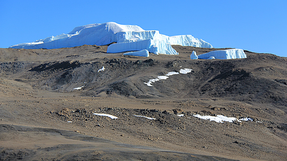
It was 8:05 when I arrived at Gilman’s Point, just over an hour after leaving the summit. The downhill around the crater had been relatively easy, taking around half the time it had taken to go up. From here, I had my final view of the crater before heading down the Jamaican Boulders. The brownish grey crater was rather bare, but the crater walls on the other side had iceberg like glaciers. It was strange seeing these icebergs in the sky just five degrees from the equator, and over five kilometres up in the air. There was the Furtwangler Glacier (named after the leader of the fourth expedition to successfully reach the summit in 1912) standing dominant like heaped icing on top of a cake.

Gilman's Point |
The crater itself was very Martian like, with the yellow grey rubble covering the surface. There were signs of liquid water that had rushed down the slopes into the bottom lunar crater.
Here I put the camera away, and wouldn’t take any more pictures until leaving Kibo later in the day.
Going down the Jamaican Boulders was fairly slow going, and I think this is where the others had all extended their lead from me. My guide Imara stayed with me though until we got to the top of the scree slope.
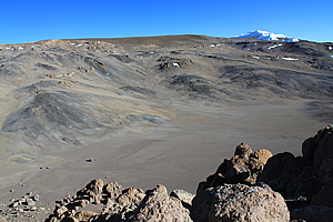
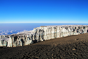
Massive crater of Kibo Peak |
Like most scree slopes I had been on, the rubble was quite thin at the top. I could see all the way down the mountain where the track we had taken uphill had gone from side to side. Now I was taking the downhill along a slip going straight down. It was tough going to start with. I was using my pole, and Imara gave me one of his poles. Perhaps I should take two poles on these trips from now on.
It was not long though before I reached the easier slope where the scree was thicker. Thankfully my gaiters kept all the stones out of my boots. I was making steady pace. My lips were also getting very dry.
Finally we reached the cave at Sebastiaan Meyer Point where the slope gradually lessened. The huts at Kibo appeared to be a lot closer now. The scree became very thick, then suddenly quite thin again. I was on a roll, but still going slower than I should have been. Exhaustion was starting to set in now. I had been hiking for nearly eight hours now and knew there was still a long way to go to get down to Horombo.
Finally we were near the bottom where the scree slope seemed to divide into several parts. By now I felt the air thickening, and could breathe easier.
I kept looking at the hut, and it had the illusion of getting further away with increasing exhaustion. The cloud that had silently surrounded the mountain at sunrise was lifting now and enveloping us in patchy cloud as it rose up the slope. Now I was questioning my sanity. Why do I put myself through these tortuous treks? Sure going uphill and reaching mountain summits is great, but I can’t stand the downhills.
This was the case in most mountains I have ever climbed in the past. Although the uphills were always gruelling and slower, it was the downhills that posed the most challenge for me.
We walked in between two rock formations near the bottom of Kibo Peak before the hut suddenly reappeared. This time it was very close. What a relief.
I was exhausted upon entering the hut at around 9:30, having walked for ten hours solid through tough conditions. It was deathly quiet in there and still freezing cold. Cloud had started overcoming the area, so there was no chance of it getting warmer than freezing today. I entered our bunkroom, and saw everyone else in my group, all fast asleep. They had all arrived here over the past half hour, and some less than ten minutes before me, but somehow they had all crashed. I was relieved that I was normal and not the only one completely exhausted from the ordeal.
I was too exhausted and numb from the cold to even photograph the amazing view back up the mountain even though the cloud had temporarily cleared from the slope.
I took off my water bottle and crawled back into bed. It was freezing in the room, but quickly the sleeping bag warmed and I fell asleep.
<< Previous | Next >> |
|
||
About this Page
|
||
|
|
|
Where is Walkabout Jeff? |
|
|

|
|
What is happening in Walkabout Jeff's hometown?
|
|
|

|
|
Who is Walkabout Jeff?Any normal person's idea of going out involves going to the local pub for a drink with a few mates. Walkabout Jeff isn't normal.
|
|
|

|
Follow Walkabout Jeff |
|