|
||||||||||||||||||
|
||||||||||||||||||
Home > Diaries > 2022 > 958 |
||||||||||||||||||
|
||||||||||||||||||
|
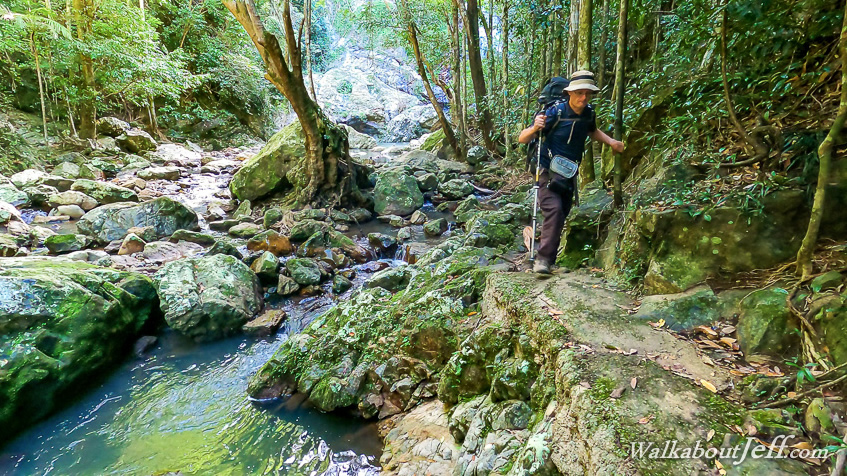
STARTING from my campsite shortly after sunrise, I headed through the silent camping ground to the nearby junction of the great walk track. From there I turned continuing northwards along the ridge which quickly began descending a steep gully towards Baxter Creek. The early morning sun filtered through the bright green vegetation of the cedar forest. The track descended along a series of switch backs dropping along the side of the valley. I could hear Baxter Creek cascading along the bottom of the valley even though I was still over a hundred metres above the water. The open forest gradually closed with thicker undergrowth gradually changing from dry cedar forest into dense rainforest as I approached the bottom of the valley. The track suddenly reached a junction at the bottom of the valley. I initially took the left hand trail going over a swingbridge precariously strung between two enormous boulders with the stream cascading below. I crossed the swingbridge, then returned across it back to the junction, from where I continued heading upstream towards Baxter Falls. The track followed the creek upstream negotiating its way around huge boulders and trees but making for easy access to a large pool into which Baxter Falls fell about twelve metres into. I rested here briefly before starting the long climb up the track back to the campground, passing several other people heading towards the falls, including the couple who had stayed at the Flaxton Walkers Camp hiking along the great walk towards Ubajee Camp tonight. Upon reaching the camping ground, I packed up the tent and headed back out along the track to Flaxton Mill Road. From there I headed towards Baroon Dam, stopping at the junction where Narrows Road descending to the dam turns off from Western Avenue. From here I walked back along Western Avenue passing farms and lifestyle blocks to reach Mapleton. From there I followed the footpath southward along the top of the range as far as it would go, getting close to Gerard's Lookout. Upon reaching the end of the path, I turned back along the top of the range and back along Western Avenue to where I had parked. I headed down Narrow's Road as the low cloud thickened overhead. I reached the lake, exploring the top of the dam to a little rest area and a couple of viewpoints from where I could see Obi Obi Creek spilling across the top of the dam and heading down the valley below which I was hoping to explore sometime soon. The sun was getting very low and the clouds were clearing as I returned along the top of the dam to the Baroon Day Use Area where I rested with a good view across the lake to the low hills on the other side watching the water birds. The sun sank beneath the hills as I continued exploring the day use area and found a grassy area and some rocks from where to watch the sun setting. The air quickly cooled filled with the screeches of hundreds of sulphur crested cockatoos settling into the trees around the day use area for the night. The setting sun brilliantly captured the tops of the fast moving clouds coming from the south east as it set behind the horizon. The sky gradually darkened to shades of yellow and purple before going a dull red colour reflecting the ash from the Tonga Volcano still suspended in the upper atmosphere. I stayed there until the sky had almost completely darkened, then the gibbous moon rose on the other side of the hills behind me, once more illuminating the sky. It was getting cold now, so I settled in my accommodation for the night. |
||||||||||||||||||
|
||||||||||||||||||