|
||||||||||||||||||
|
||||||||||||||||||
Home > Diaries > 2022 > 1017 |
||||||||||||||||||
|
||||||||||||||||||
|
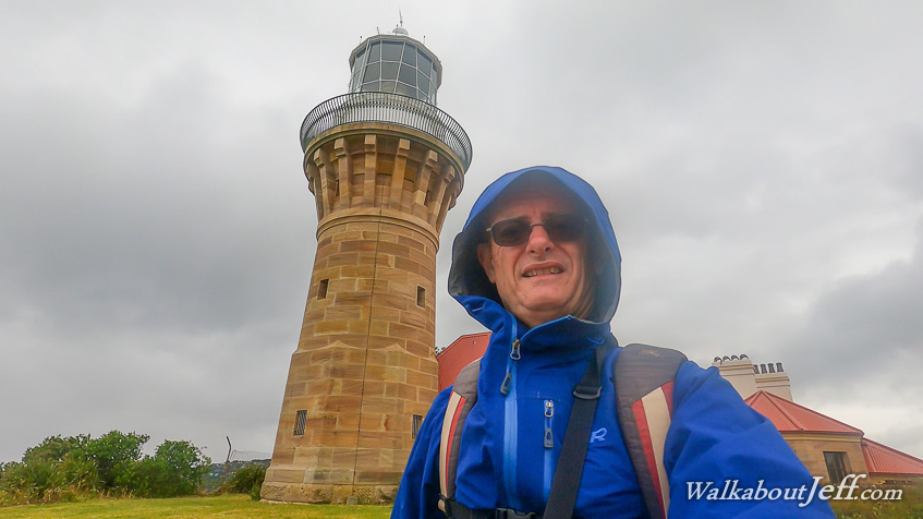
THE MORNING dawned cool and rainy. I decided even given these conditions, today would be a good day to start my hike of the Sydney Coastline. I had seen a couple of online guides for doing a long hike of the coastline. There were numerous walking tracks running along the coast mostly linking up all the way from the very top of the Sydney area, down to the top of the Illawarra, covering over 200 kilometres of track. I decided to attempt to do as much of this as possible, giving myself 12 days of hiking over the 15 days I have remaining here. Today I decided to start at the very top of the trail and work on it sequentially. Normally on a multiple day hike, I'd pack a backpack with a tent (or book huts) and all the food I need. This trip was different, staying in the city centre and taking public transport each day to the start and from the end of each section of track. This means I don't need to carry a tent (not that there is anywhere to camp along the coastline anyway) and won't need to check in and out of different accommodation each day. I would therefore only need a small day pack for each day. Catching the train up to Circular Cay, I headed to the ferry terminal catching the first boat across to Manly on the north shore. The strong wind and occasional rain made the trip across the entrance of the harbour quite bouncy. Once I arrived in Manly, I headed to the nearby bus station to catch the Palm Beach bus. It was a long trip up along the north shore, but I finally arrived at my starting point at the Palm Beach Wharf over two hours out from the city. This was the longest pre-hike trip for the entire trek. Once at the wharf overlooking the sheltered inlets of Pittswater, I set off along the path towards the Barrenjoey Lighthouse about three kilometres further north. After one kilometre the road ended and I walked along the Governor Phillip Beach, with Palm Beach on the other side of the sandbar. I could hear the ocean waves breaking on the other side of the sandbar, but the water on this side was relatively calm despite the strong wind. Rain was falling as I headed up the beach. Eventually I reached the start of the lighthouse track near the end of the beach. The track moderately climbed the headland made from sandstone. It was quite a climb to reach the Barrenjoey Lighthouse. I rested at the lighthouse marking the northernmost point of the trek. From here it is all southward towards the entrance of Sydney Harbour which I'm expecting to reach after 2 or 3 days of hiking, depending on how far I can get each day. There is a continuous trail from here to Manly Beach about 40 kilometres away. This is the Bicentennial Coastal Walk which goes over walking tracks where possible, but some of it follows the beaches and parts go along road footpaths. Looking south the narrow sandbar of Palm Beach extended about a kilometre and a half to the next group of headlands with sharp and erratic cliffs towering out of the turbulent sea. After resting at the lighthouse I descended the steep Smugglers Track back to the sheltered beach before taking the first track across the sandbar to Palm Beach. Large waves were breaking and very few people were on the beach. I walked on the coarse sand well above the high tide line towards the village of Palm Beach, with its large mansions overlooking the sea. Upon reaching the end of the beach I took a track through Horden Park up a long staircase to Florida Road, which I followed (as part of the North Shore Bicentennial Trail) to Whale Beach Road heading around the headlands and descending to Whale Beach. There was nobody else on the beach. The rough seas and strong south easterly wind had closed all the beaches along the north shore as they were too dangerous to swim or surf in. This was great with the beaches being very quiet, but did mean I had to battle a head wind. Upon reaching the end of the beautiful golden Whale Beach, I tool a stairway up onto another road which the track followed for about two kilometres before reaching the start of the Bangalley Head Track. After climbing a lot of stairs the track levelled off as it headed through the scrubby forest a short distance in from the sheer cliffs dropping into the turbulent ocean. There were a couple of viewpoints over the edge. Upon rounding the point the track dropped to a grassy park where the track followed before continuing along a footpath dropping to Avalon Beach. I walked a short distance along the beach before following the path through Avalon Beach Reserve. At the end of the reserve was another road walk before a steep drop into Bigola Beach. Another bushwalk around South Bigola Head brought me to the long Newport Beach. The terrain was getting less rugged as I was heading south. Near the end of the beach the track diverted to follow a road rising to cross another headland. The road steepened as I climbed it. Upon reaching the top there was a steep drop down the other side to a narrow steep road dropping to the the remote Bungan Beach. Heading down this road a lady was trying to walk a dog which refused to walk. I've never seen a dog so resistant to going for a walk before. Upon reaching the bottom of the road I reached the Bungan Beach lifesaving club before walking out onto the beach. The headlands on either side were very steep and there were no houses visible on the steep slopes. I walked along the beach until reaching the rough track steeply rising to an equally steep street coming out to the main road. This is where I had initially aimed to reach today, having clocked 19 kilometres. I was still going strong, so decided to keep going. From here the track followed a footpath along the very noisy road descending to a side road which I took to Boggin Boggin Bay. From there I had a bit more road walking until reaching Mona Vale Beach. After a day of head winds, constant cloud and scattered showers, the sun suddenly came out. The wind was still blowing strong but decided this will be as far as I go today. From here there was a short road walk along the golf course to catch the bus back to Manly - a trip half the length of this morning's bus trip having hiked 21.7 kilometres today covering almost half the distance to Manly. Upon reaching Manly, I caught the ferry back across the harbour, then the train back to Town Hall where I had dinner, returned to the capsule hostel, downloaded the photos and video from the day, and promptly went to sleep. |
||||||||||||||||||
|
||||||||||||||||||