|
||||||||||||||||||
|
||||||||||||||||||
Home > Diaries > 2022 > 1022 |
||||||||||||||||||
|
||||||||||||||||||
|
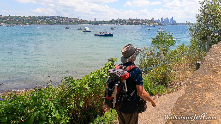
THE SKY was overcast when I walked the short distance to my start point under the CentrePoint Tower where I had left off yesterday. From here I followed Pitt Street through the short mall and continued following the dark and narrow street until arriving at Circular Cay. From here I followed the coast going around the end of the opera house and into Farm Cove on the other side. Heading towards the back of the bay, I entered the Royal Botanical Gardens where I had explored yesterday, but this time keeping to the coastal path. A stone wall separated the path from the bay, but water was seeping through from the very high tide. In some places the water came almost all the way across the path. Upon reaching the back of the bay, and going around a short diversion where fireworks was being set up for New Years Eve, I descended to the end of the point and rested at the famous Mrs Macquaries Chair before heading into the long and narrow Woolloomooloo Bay, with the gardens on this side and a line of grey military ships on the other. Upon reaching the back of the bay, I walked along Finger Wharf with its interesting statues before following the trail on the other side of the bay next to the naval base to the left and military residences to the right. By now most of the clouds had cleared and the sun was out. The road doubled back over the top of the low ridge into Elizabeth Bay, where I continued following the high rises before reaching a small park descending to the back of the bay. Here the path crossed a flat grassy park with the still water filled with moored boats to my left. Heading around another small point, I reached another park at Rushcutters Bay which I followed around to the end of Darling Point where one of the city ferries comes to. Here I stopped at the parkland watching one of the Sydney to Hobart yachts sailing the turquoise water a little off the point in preparation for the race in a few days. Following Darling Point Road along the ridge, I descended to Double Bay walking along the path above the beaches and exploring a couple of small parks before following the road around Point Piper, Australia's most expensive real estate where houses here sell in the tens of millions of dollars. Reaching the other side of Point Piper, I descended to Bellamy Beach briefly before following the long path beside Rose Bay. Like other bays there were a lot of boats moored offshore and sea planes were taking off and landing along a marked strip in the bay about a kilometre away. I passed the ferry wharf before continuing along the north eastern end of the bay. Eventually I reached the end of the bay, entering another section of Sydney Harbour National Park following the Hermitage Foreshore Walking Track (still part of the Manly to Bondi trail I have been following since Circular Cay). The track passed some interesting sandstone formations before reaching a seat at a viewpoint looking up the harbour back towards the city. From here the track followed the rocky coast around the point to Queens Beach, then around the next point to Hermit Beach then around a few more bushy headlands to eventually reach the busy Milk Beach. Behind the beach was the historical Carrara House. I explored the area containing the ruins of several large houses on the point before returning to the track and following the boardwalk through the grassy headland around to Shark Bay which was closed with the beach being reconstructed following a lot of erosion in recent years. From Glass and Bottle Point, the track followed footpaths through a residential area passing Beach Paddock with a brief view of the sand flats. After another crossing through residential area, I descended a long stairway to cross a large swingbridge across the end of Parsley Bay before another residential area before reaching Watson's Bay. Upon reaching the golden beach of Watson's Bay, I followed the path around to the ferry wharf to conclude today's 23.2 kilometre hike from the city, having hiked 127.6 kilometres since starting six days ago. I climbed on the ferry and it departed speeding off across the calm water around the headlands I had followed this afternoon before heading into Rose Bay and stopping at the wharf there. With more people aboard, the ferry headed around the points I had rounded this morning making its way back to Circular Cay, from where I caught a train back to the hostel. |
||||||||||||||||||
|
||||||||||||||||||