|
||||||||||||||||||||||||||||||||||||||||||||||||||||||||||||||||||||||||||||||||||||||||||||||||||||||||||
|
||||||||||||||||||||||||||||||||||||||||||||||||||||||||||||||||||||||||||||||||||||||||||||||||||||||||||
Home > Treks > Outside Australasia > Mount Kilimanjaro > 4 |
||||||||||||||||||||||||||||||||||||||||||||||||||||||||||||||||||||||||||||||||||||||||||||||||||||||||||
|
||||||||||||||||||||||||||||||||||||||||||||||||||||||||||||||||||||||||||||||||||||||||||||||||||||||||||
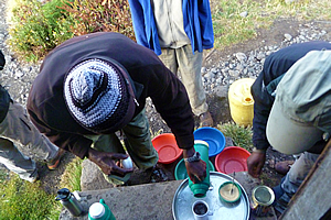
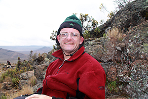
Introduction to today's journeySomewhere between the bottom of the climb and the summit is the answer to the mystery why we climb. - Greg Child Today's trek starts at Horombo Huts following the Mawenzi Peak track past Zebra Rocks returning to the main track at the end of a long plateau between Kibo and Mawenzi peaks. Upon returning to the main track, it rises moderately to our base camp at Kibo Hut. Today's JourneyDistance trekked today: 13 kilometres. Total distance trekked to date: 37 kilometres. I WAS freezing cold when I woke up despite being well wrapped up in my sleeping bag. Gary was already up and talking with Jim. I quickly put on my warmest clothes – my thermal trousers I had picked up in Lima before doing the Inca Trail last year, my polar fleece top and my alpine hat. I had just finished getting dressed when there was a knock at the door. It was Jaseri and three of the porters, with four bowls of warm washing water and four mugs into which they poured tea. I had three sugars as I was now in the three to four thousand metre altitude range. The air outside was freezing – too cold to have a proper wash like the one we had yesterday. The tea was very refreshing though, warming me up a little.
Once finished my cup of tea, I walked up the hill to use the toilet. The icy ground was very crunchy under my boots. The ground near the toilets was frozen solid thanks to the water from a leaky tap freezing solid. The sky above me was perfectly clear though, and the sun was soon to rise above the jagged spurs of Mawenzi Peak towering to my right. To my left was the Kilimanjaro summit poking over the ridge, some two thousand one hundred metres above me. It was hard to believe that all going well, I will be reaching the summit at about this time tomorrow.
I recalled a few weeks ago my doctor advising that once over three thousand metres I should not increase my altitude by more than three hundred metres in any given twenty four hour period. I was going completely against her advice by going seven times that amount today. The yellowish pink summit was already brightly illuminated in sunshine. How nice it would be for the people up the top being able to experience the warmth of the sun. The mountain was leaning over with the left hand side to be a little higher than the right hand side. A snowfield partially covered the higher left hand side, shining brightly. The nearby ridge and hut area was still in the shade and below freezing.
Looking down the mountain in the direction we had come up yesterday, it was quite hazy down there, with low cloud about fifteen hundred meters below us. The haze created an interesting layering effect in the purple grey ridges and the small volcanic cone we had passed yesterday now far below us. I had a bit of traveller’s diarrhoea as I generally do when at altitude. I made a note to take an Imodium tablet at breakfast to deal with the sudden ache in my intestines. The porters told me the water is boiled and filtered, so I wondered where I got these stomach cramps from. I crunched through the icy scree back to the hut where the others were getting ready to leave now rugged up. I quickly collected my cold water bladder and headed to the dining hut with the others, taking my Imodium tablet on the way. Thankfully the ache in my intestines very quickly subsided.
We entered the dining hut to have breakfast. It was the usual plate of fruit and porridge, which I couldn’t stand. Dawn was sitting next to me and had a large plastic container of mega magnesium powder. I found it quite intriguing, so she said I should try some as it relieves the muscles and joints and is good for stress management as well. It was very nice tasting like artificial raspberry. I also drank plenty of tea. I managed to eat quite a reasonable meal of toast whilst the others had porridge. Then came cooked sausages, tomato and scrambled egg.
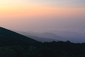
The sun was shining deceptively weak when we left the hut. I knew though that the radiation would be very strong up here. I collected my cold water bottle and returned to the hut to pack up. It was still very cold outside but definitely starting to warm up. The frost hadn’t started melting yet, but no doubt it will do so pretty soon. A thin layer of cloud was approaching the bottom of the summit area, so it looked like another cloudy day will soon be upon us. There was some high cloud in the direction of the bottom of the mountain.
The waning gibbous moon was still high in the sky now directly above the summit, and still surprisingly bright even though the sun was up. It was a sure sign of the high altitude with being above the soup of the low altitude orange brown dross that covered the vast plains of Tanzania now over three vertical kilometres below me. The air very quickly warmed to the extent that I could take off my alpine hat and polar fleece top, being down to a polo top over a thermal top. Cloud now started to envelope the sharp spires of Mawenzi Peak.
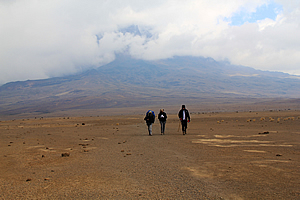
We entered the reception hut to sign out. We were ready to leave the Horombo Huts area to proceed towards Kibo Hut. Once signed out we started the slow climb up the moderately steep dirt trail, reaching a large obelisk after about a hundred metres. To the left was the lower route to Kibo Hut – 9.26 kilometres. To the right was the upper route to Kibo Hut 10.16 kilometres or Mawenzi Hut at 5.49 kilometres. Zebra Rocks was 2.4 kilometres away. I had recalled Desmond the other day referring to the upper route as the Marangu Hotel route, and we took this route as it was apparently far more interesting than the lower route. Here we were starting the day at about the altitude of New Zealand’s highest mountain, about to venture onwards to altitudes higher than I have ever been before.
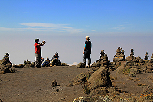
The track roughly followed the top of the ridge rising moderately. It was very slow going in the thin air. We had spectacular views over the gully filled with scattered alien Dendrosenecio Kilimanjari trees below sweeping up to the rugged Mawenzi Peak, Africa’s third highest summit now visible. The thick scrub along this ridge was only knee high, a stark contrast to the thick cloud forest we had been in up until this time yesterday. We passed a small area of about twelve small cairns. Jaseri led, Vicky was second as she seemed to be insisting on now, and I was next, followed by all the others.
I asked Jaseri if he had ever climbed Mawenzi Peak. He said that he had done it three times in his younger fitter days. I asked him if it was dangerous. He said that one in every thirty people who go there die in their attempts to scale the summit. It was very dangerous, even more so than Mount Everest. This was very sobering for me with now only being a few kilometres away and fourteen hundred metres below its summit and even more sobering knowing that I was climbing to an even higher altitude over the next twenty two hours.
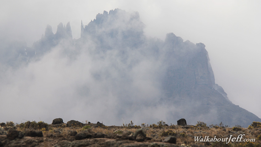
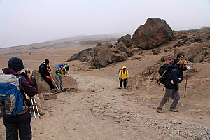
It was a slow two hours after leaving Horombo when we arrived at some interesting cliffs in the rocks above us. By now there were quite a few small clouds around. I could hear someone ahead of us playing a small flute. It was one of our guides Imara who had gone on ahead. The flute created a very interesting atmospheric life to it in the midst of this otherwise barren landscape. We were at the Zebra Rocks. There were numerous stone cairns beside the track. They were so named because the formations had vertical layers of black and white just like the zebra’s stripes. I had never seen a volcanic formation quite like this before. To me it looked more like limestone than any volcanic formation, but at almost four kilometres above sea level the formation of limestone would be impossible.
Mark and Jono asked me to photograph them, so I was happy to oblige. Once we had all photographed each other they had mentioned they were talking with another small Canadian group who were staying at Horombo an extra night being on the same six day itinerary as Levi and Rachel. Jono had agreed to create a traditional Canadian Indian cairn at the Kilimanjaro summit for them to see the next day. They explained the tradition to me. Mawenzi peak was becoming enveloped by cloud now, so it would appear there was not going to be any more clear views of it today.
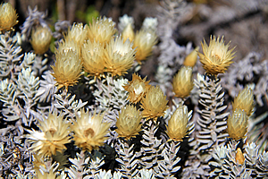
There was some strange everlasting daisy like dark cream coloured flowers here. They were on stems with small elongated silver grey almost succulent leaves. Here we sat and rested whilst Imara continued to play his little flute from his solitary rock outpost. We left the Zebra Rocks, following the loose trail running parallel to the on-going diminishing row of cliffs. The terrain started to ease here as we reached a small plateau with Mawenzi Peak almost directly in front of us now. A small black pregnant lizard scurried away from us on the path. This was the first animal I had seen since leaving the forest at Mandara yesterday.
As the plateau levelled, we found ourselves walking through a very wide gully over fairly flat terrain. Four hundred metres away the track ascended to a very low pass. The scrub was now very scattered, with the ground mostly being small boulders with the grasses and very short shrubs nestled against them for shelter. To our left was a low hill with rocky outcrops and to our right was the sharp craggy Mawenzi Peak. The flatness of the local terrain made it very hard to believe we were now over four kilometres above sea level. From Zebra rocks we slowly proceeded to the pass. At sea level this would have been a very easy brisk walk doable in a wheelchair. At around four thousand two hundred metres above sea level, we were struggling up the hill at a very slow pace.
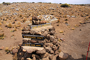
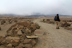
Finally we did reach the pass, which I guessed to be about the same altitude as the highest point on the Inca Trail, the highest I have ever hiked. Here we stopped and had a rest each sitting on a boulder surrounded by the everlasting alpine yellow daisy. There were a few small cairns beside the trail. There was still a lot of cloud hovering around Mawenzi peak, but nearly all of the side facing us was still clearly visible. The jagged tops made the mountain look very ominous with needle sharp vertical spires giving it a very gothic look in the swirling cloud. We had a few photos before continuing on. The track briefly descended before rising again on a very gentle slope. We reached two piles of rocks, one on either side of the track. Both piles had a sign rising above it. The pile of rocks to the left had a small sign pointing down a track to the right – Mawenzi Hut 1.525km, and another small sign pointing in our direction – Kibo Hut 6.199km. Our group had only walked four kilometres in two hours. We were still only a third of the way to Kibo Hut. The main pile of rocks to the right had an old post with simple pointers to Kibo, Horombo and Mawenzi without any distances.
We continued uphill for another fifteen minutes before reaching the highest point of this section of track. From here we could see across a very large saddle that dropped about fifty metres before gradually rising again to the main summit area of Kibo Peak now encased in cloud. This was where we were heading. The cloud was a bit too low to see the next hut though, but Jaseri told us that it was about four hours away. I had recalled Desmond telling us about this part of the track. The hut looks deceptively close from here, but it would seem to get further and further away as you approached it. At the pass was a small metal plaque loosely placed up against a small cairn of rocks reading: In Memory Loretta Mae (Colleps) Hedrick January 29, 1931 – April 29, 1979 From the flame tree of Thicka to the Serengeti Plains. From the Mountains of the Moon to the snows of Kilimanjaro. Africa was her land. Family and friends. She had been buried up here. It must have been one hell of a funeral to be conducted up here. I’m not sure whether she had died up here or not (most likely not), but it brought home the fact that we were now in a very inhospitable place, in a place where humans are not meant to venture.
We followed the track very gradually heading downhill towards the top of the long saddle. Then the track rose a little higher to where we briefly stopped at the top. The wind was blowing now. Fortunately it wasn’t very strong, but it was very cold. The cloud had by now completely covered the sky, and if it were to rain, I guessed we would be experiencing snow. The wind reminded me of the time when I first heard about Mount Kilimanjaro. It was back in primary school in 1980 when my teacher that year was explaining jet streams, and how she used the mountain to explain that this was one place high enough to experience winds of hundreds of kilometres per hour. I don’t think she had been correct in that as jet streams only occur in temperate and subtropical areas. Here we were just five degrees south of the equator (though it definitely didn’t feel like it now) and well away from the range of the jet streams. Thankfully the chill wind was only moderate.
We reached a sheltered crag under which we stopped for lunch. There were a few small shrubs occupying the most sheltered nooks. The three guides went out onto an exposed rock about thirty metres away. There were several small robins around here and they were very friendly. Their coats were very feathery to keep out the cold, but I wondered how they could possibly survive in such inhospitable conditions here at about four thousand three hundred metres above sea level, half the altitude of Mount Everest and now three quarters the height of the Kilimanjaro summit.
The birds had obviously established themselves here because one or two groups from the Marangu Hotel would stop here each day to have lunch, and people eating lunch would no doubt drop crumbs. But these birds were so friendly and trusting that we were breaking pieces off our sandwiches and feeding them out of our hands. Nearby were a couple of very large crows. Perhaps there were some rats around here that would eat whatever the small birds left behind, creating an opportune meal for them. The crows had very large truncated beaks making them an ominous predator. They seemed to be much larger than the Australian crows.
From here the ominous Mawenzi Peak had vertical rock faces and needles making it look impossible to climb. No wonder Jaseri had said that three percent of people who go up there never come back. Mawenzi was first attempted by Meyer and Pruscheller after the first ever successful climb of Uhuru (the main summit of Kilimanjaro) in October 1889. They could only reach the top of one of the subsidiary peaks though. The main summit some fifty three metres higher was too difficult. The summit was not successfully reached until July 1912 by German climbers Edward Oehler and Fritz Klute before making the third successful attempt of Kibo.
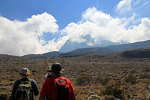
Across the saddle the cloud started lifting, and we could just see the Kibo hut. It looked a long way away to me, but I could see how people could have been deceived thinking that it was pretty close. The sheer distance across the saddle coupled with the polé polé walk at such a high altitude made it a good four hours away. A couple of small craters were near the other side of the saddle, and the hut marked the lower reaches of the final ascent up Kibo, still covered with swirling cloud. We set off through the freezing cold wind following the track down towards the saddle. There were only a few tufts of scrub now, mostly low clumps of tussock and the occasional alpine flowering plant. Cloud alternately cleared and covered the area over Kibo. Large patches of blue sky opened up ahead, but not enough to bring the sun to shine on the saddle.
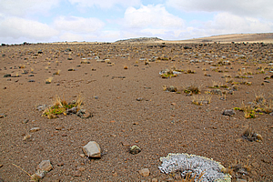
Being at around four thousand four hundred metres above sea level – now the highest I had ever been, we were hiking along very slowly. As we approached the lowest point of the saddle, the field of closely spaced boulders changed into a field of rough scoria regolith with the boulders more scattered. The plants thinned. There were large rings of lichen from where a small plant had established itself and continued growing out on itself leaving the old inner part to die. Some of these rings were up to a metre wide and would have been many centuries old.
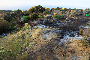
There were a few small sections along the trail where travellers past had lined up rocks to spell out words – mainly the names of their countries such as Malta. These natural looking words were effective, but somehow broke from the loneliness of the whole place. In some areas the gravel gave way to sand, where there were patterns from where the soil had become wet, then compacted as it had dried forming roughly hexagonal cracks on the surface.
We were now past the acclimatisation area and had not seen any other groups since leaving Horombo. Cloud had enveloped the area around Kibo Hut again. The vegetation here was almost non-existent now, giving the feel that we were in a very lonely place. People we had met at the huts and at the Marangu Hotel had told us this area as being moonlike, with the barren lunar surface devoid of life. I thought the scoria here was more like the Martian regolith though, coloured very closely to the reddish butterscotch colour of the Martian surface.
I have always wanted to go to Mars, but that would be impossible. No one has been to Mars yet, and no one probably will in my lifetime. No one has been further away from Earth than the Moon, which is only a tiny fraction of the distance to Mars. We are only just starting to get into the age of space tourism, where you go up to a hundred kilometres above Earth’s surface for a mere few minutes. That is only barely scratching the surface in terms of Martian tourism. I don’t believe tourism to Mars will happen until we find a way to propel ourselves quickly through outer space. With today’s technology it takes at least six months to get to Mars, and six months to get back. Once you get there you have to stay there for about a year and a half before Earth once more gets close enough to travel back.
Those timeframes are far too much. It is not until we find a practical quantum solution where we can bend the space-time continuum enough to facilitate a short passage without causing damage to the travellers. That is the big challenge. We seem to easily get our heads around the current four dimensional space-time world in which we live, but there are another twenty two dimensions of space-time that we simply don’t understand, yet alone know how to utilise, because as Stephen Hawking puts it, those dimensions are too curled to be of use. We just need to find a way of unfurling some of those dimensions to create a bridge across space. Until then, we’re stuck on Earth.
With that in mind, I realised this was as close to a Martian experience as I was ever going to get. I imagined traversing say some of the Tharsis Montes would be like this, but the air would be a lot thinner there. At the base of those mountains, the air would be similar to that of Earth at about thirty three kilometres above sea level, with less than one percent of that at sea level. The air was very thin up here, but it was still had about sixty percent of the air pressure found at sea level. The tops of the Martian volcanoes tower above the atmosphere, so you are in outer space when you reach the summit.
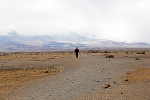
The air was terribly thin up here, but the clouds were evident that we were far from being in outer space. I then realised that I was up here celebrating my fortieth birthday, and perhaps space tourism will be cheap enough for me to celebrate my fiftieth in outer space. Food for thought. Aside from the clouds, this really felt like a Martian experience, with absolutely no life here apart from ten people, seven tourists from different parts of the world, and three guides, struggling along. Finally Jaseri signalled that we needed to stop. We were at the bottom of the saddle now. As we rested, a sole hiker approached us from behind, and passed us, doing quite a good pace. He passed us, and gradually disappeared into the distance towards Kibo. At the rest stop I gave my camera to Vicky, and she took a few shots of me walking off into the distance and coming back. I figured if I ever needed any photos of me in a very lonely and remote location, this would be it. When I returned, it was time for us to move on again. I thanked her for taking my picture and we talked as we staggered our way across the Martian landscape.
The cloud was quickly rising along the edge of the saddle about a kilometre away. Part of the cloud mass was obviously rain-bearing – or perhaps snow-bearing. It was very cold here. Snow would have been nice. Rain on the other hand would have been miserable in these frigid conditions. I asked Vicky why she was up here on Kilimanjaro, especially as she has not done much hiking at all in the past. She was just here as part of a longer tour that had started off in the Serengeti. She didn’t have any real reason to do this but decided it was definitely going to be a once in a lifetime experience. She told me that her sister had thought she was doing this journey up the mountain to find herself. After all many people go off to far flung places and put themselves through the torture of hiking in inhospitable places as a way for them to find themselves.
I really liked that idea. I mentioned to her that I go on these hikes quite often, and as I do so, I find out a bit about myself. Several weeks ago I had a friend who would tell me that a lot of people go off and do weekend courses paying thousands of dollars to a motivational speaker in the hope they would find themselves. That sounded boring to me. If I wanted to spend thousands of dollars to go and find myself I would much rather do so in a ridiculously exotic location such as this – exactly as I was doing now. As much as I do love attending weekend seminars, going on an adventure like this is far more effective than any formal program.
I told Vicky the reason why I was up here. As a child I was the least fit of my peers. Looking back then I would have been the last person to have ended up being the fit adventurer. Funny how I was the runt of the litter back then, but in recent years with the emergence of social networking technology, I had been surprised to have seen that the really fit and popular classmates who I would have thought would have be very athletic throughout their adulthoods looked surprisingly old and out of shape. I think I’m the only one from my school who has done these treks even though I should have perhaps been the one who ended up in a wheelchair.
I suppose as a way to prove myself, and to find myself, I was on track to observe the celebration of my fortieth birthday by reaching the summit, which was now unseen. Most mountains I have climbed over the years have had one thing in common. The summit was never clearly visible until near the very top. Sometimes I would think I would see the summit only to become disappointed upon approaching the top to see there was more to go. On one or two mountains I have climbed, this has occurred not once, but several times. Each time I could have easily given up and turned back, but with my failure is not an option approach to this I’d always pressed on to reach the summit. In fact to date I have never turned back having fallen short of a summit attempt. Pressing on when every muscle in your body is screaming to turn back builds character.
That being said though, this was my first seriously high climb into dangerously high altitudes. I was already higher than I had ever been before and only five or six hundred metres below the danger zone at five thousand metres. Every step of this journey was a bit of a step of faith for me. The weather conditions here on the plateau were very tough now causing my lips to crack. I was now beginning to doubt my ability to reach the summit in about seventeen hours’ time, especially with a long overnight climb tonight. I was thankful though my legs were no longer as sore as they had been over the past two days. The sudden exertion from climbing to the waterfall at Marangu was over. That was now a full three vertical kilometres below me in much warmer climes.
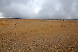
The slope of the plateau was starting to grade upwards in anticipation of the now enshrouded Kibo Peak, giving a disorienting illusion that the world was tilted up. Well this part of the world definitely was a bit tilted. The assortment of boulders that had been strewn over the regolith in the early part of the plateau had gone now and the flat regolith was just shingle rubble with absolutely no vegetation. This really was alpine desert here – how could anything survive up here?
At times it would appear Kibo Peak was getting closer but most of the time it actually seemed to be shrinking away. The gradual slope towards it was gradually steepening making it even more difficult in the increasingly thinning air. It was very cold and we were all rugged up, but fortunately it hadn’t started raining or snowing. The area over Mawenzi Peak and the pass we had crossed earlier was all fogged over and appearing to rain now. We were struggling along now at over four thousand five hundred metres above sea level. It was deathly silent and very lonely here. The only sign of life was my fellow hikers staggering along against the inhospitable conditions of this barren alpine desert.
Suddenly the cloud blocking our view of Kibo Peak lifted in front of us just enough to see Kibo Hut. It definitely was a lot closer now, but still little more than a couple of dots ahead of us. Now I realised there is going to be quite a climb, with at least a hundred metres of vertical rise up to the hut. That last bit was going to be a killer. A hundred metres climb is nothing at sea level, but at four and a half kilometres above sea level after walking for three days this was going to be a huge spirit-breaking challenge. Beneath the hut, at the start of the climb, I could see a group of people resting. This must be where the upper and lower tracks meet. Most people hike the lower trail, so it wasn’t going to be as lonely any more.
After another five agonising minutes, we reached the junction. The two trails met in amongst some huge boulders thrown down from Kibo Peak perhaps hundreds of thousands of years ago during the great eruptions, or carried down by glaciers when permanent ice covered the whole of Kibo Peak for tens of thousands of years up until just around eighty years ago. The main track from Horombo met the smaller one we had been walking on across the plateau. The main track had come from a pass over the edge of the plateau between two very Martian like hills. The track was like wide enough for a four wheel drive vehicle to easily negotiate.
At the junction was a small pile of rocks cemented together with a couple of signs on it. The first sign read Jiwe La Ukoyo – the name of the junction. It means pointed rocks, supposedly at 4394 metres above sea level. Another sign lying on the rock, having obviously become detached from its original mounting, had two arrows. One of the arrows pointed back down the main track saying Horombo Hut 7.8 km. More importantly the other arrow said Kibo Hut 1.46 km. There was another sign across the track saying Mawenzi Hut 6.27 km. The hut is at 4703 metres above sea level.
That last one and a half kilometres with a three hundred and nine metre rise in a one in five gradient was going to be tough so we stopped at one of the metal picnic tables for a rest and afternoon tea. The cold aluminium table top was no wider than each bench that we sat on, but it was perfectly functional. Thick mist obscured the climb up to the hut, but I could still see it through the clouds and I could still see the track winding its way backwards and forwards across the face of the slope before disappearing behind some more huge boulders which had no doubt rolled down the mountain in times past perhaps during a violent eruption.
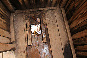
Having been drinking as much as I possibly could, I needed to use the toilet, and fortunately there were a couple of long drops handy. I was getting very cold very quickly, so I had to get up anyway. I staggered over to the nearest toilet with the aid of my walking pole. The derelict wooden long drop stood over a hole that had expanded beyond the floorboards in front. I was surprised the entire toilet hadn’t fallen in. In the hole I could see a huge pile of faeces and toilet paper coming to within a few centimetres of the bottom of the hut. Although it was almost frozen, the stench was unbelievable, and I tried to hold my breath for as much as I could, but that was impossible to do here in the very thin oxygen-starved alpine air.
I went to use the toilet. There was a faecal stool sitting beside the square hole in the floorboards where you are supposed to aim. People don't aim too well at high altitude so it seems as most of the floor was saturated with urine that didn’t make it in the hole. That all being said, when you gotta go, you gotta go, so I took what will have to go down in history as being the most nauseatingly disgusting piss I have ever taken. On my way back to the group I saw Dawn who also had an obviously strong urge to go. I told her that I hope you have a strong stomach. She took one look at the toilet and decided to hold on until she got to Kibo.
Quite a lot of porters were passing us carrying gear from Horombo to the Kibo base camp. It had been very quiet walking across the desert as we had been the only group and it had been porter free. Despite their enormous loads on their heads, the porters were still walking along comfortably oblivious to the polé polé that was being drilled into all the tourists. Perhaps their lungs had enormous capacity like the Incan descendants I had encountered in Peru. Whilst watching the porters walk by, we sat at the freezing cold aluminium picnic table nibbling on our leftovers from lunch, feeling quite tired, cold and having a bit of a loss of appetite from the altitude.
It was very painful getting up. My muscles were almost locked up and certainly didn’t want to move. We set off and started staggering along the track again like old people in a rest home going for a stroll with their walking frames. The slope started off fairly slight, but gradually steepened. Soon we were climbing up the moderately steep section, perhaps just fifteen to twenty degrees, but it felt far steeper at such high altitude. Jono was still going well despite his fifteen kilogramme pack. Jaseri had apparently told Jono’s porter to just take his pack off him at the first opportunity, but Jono managed to evade the porter as he was determined to take his pack all the way up to Kibo. With a little over a kilometre to go it looked like he was going to be successful. He was stuffed, but I don’t think he was at all regretting having taken it all the way up here. This will certainly be a first.
We took one agonising step after another, all keeping together following Jaseri’s lead. The cloud rose before us, so we were never enveloped by it. For a while we completely lost sight of the huts as we passed under the big bluffs. Losing sight of the goal was heart breaking. Finally the hut appeared again, and now they were a lot closer, along with a number of green tents that had been pitched in the area. One of the green tents had a large Canadian flag draped over it, so this must be a big group from Canada. The orange and grey domed tent I had seen yesterday at Horombo was pitched up here too.
We staggered past the main hut to a smaller stone hut where we needed to sign in. Here I got Vicky to take a photo of me in front of a sign before signing in. The sign read: Welcome to Kibo Hut 4700 m alt. Above it was a larger sign – Gilman’s Point, 5 hours, 5685 m ASL. There was nearly a whole vertical kilometre of climbing over five hours to get to Gilman’s point, then another two hours to the Uhuru summit. This was going to be a long night. Freezing cloud very quickly enveloped us, so I joined the others in line to sign in. Once we all signed in, Jaseri led us back to the main hut. The frigid cocoon of fog obscured our brief walk to the stone hut with corrugated iron roofing. It was the largest of several huts in the area. Above the hut were the toilets, which I noted. The upper side of the hut was set into the hill possibly as an attempt to insulate it. It must have been very challenging excavating and building this hut in such thin air.
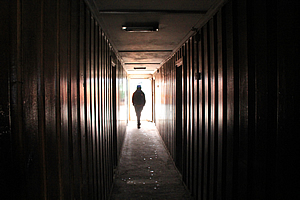
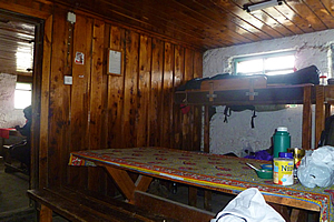
A long wooden corridor met us inside the bitterly cold hut. The floor was solid concrete slab and the walls were dark timber. Along the walls were doors into the bunk rooms. They all had large bolts on them to keep them closed and locked when the occupants were up the mountain on their summit attempts. We walked all the way down to the end and entered the last bunk room to the right. It had bunks all around with a wooden picnic table in the middle. The inside walls were all warm coloured timber and the outside walls were all white washed brick. I set up in the lower bunk at the far right hand corner and everyone else set up their bunks. It was absolutely freezing in here. The one thousand metre altitude difference from Horombo to here made for a huge temperature drop. Although this should be the warmest part of the day, it must have been below freezing here. I wished the sun would come out to heat it up a bit, but that wasn’t going to happen today.
There were already four people in the bunkroom beside our group. They were all Japanese people. They all looked pretty young, but one of them was already in bed with a very severe hacking cough. None of us said anything but it was obvious we all thought he should even attempt to climb the mountain tonight, but his fellow travellers said he has already climbed to the summit Mount Fuji twice. Well that didn’t count as we were almost a kilometre higher than Mount Fuji, and the summit was another twelve hundred metres above us. I hoped he wasn’t going to keep us awake tonight. If we ever needed a good sleep, it will have to be this evening as tomorrow was going to be a very long day indeed.
Our porters came in and gave us a quick afternoon tea. It was nice to get some hot tea. Being at over four thousand metres above sea level now, I felt obliged to have four sugars. That certainly gave me a buzz, but it also gave me the urge to use the toilet, so I put on my woolly hat and staggered out of the hut and up to the toilets. There were two lots of toilets segregated by a green corrugated iron fence. Down the bottom were three tourist toilets, and at the top were two porter toilets. I didn’t know which ones would be better, but obviously I took the tourist ones.
Each toilet was a single cubicle, which I closed the door for privacy. The toilet room was tiled over the floor and up the walls to the ceiling. On the floor was a hole with a squat toilet nicely installed with a lot more craftsmanship than the last toilet I had seen. It certainly wasn’t gross like the one I had used at Jiwe La Ukoyo. As I returned to the hut, the sun suddenly came out. This was the first sun I had seen since the low pass just above Zebra Cliffs. The sun was very bright and the sky a deep blue. Unfortunately the crisp wind was so cold that the sun did little to heat the air.
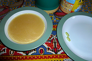
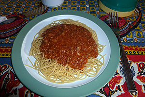
I returned inside just in time for dinner. Fortunately it was quite dark inside the hut, so I could start jet lagging and acclimatising myself for the night. We started off with a warm yellow vegetable soup with which I took another two gingko biloba tablets. I had taken two during breakfast and two at lunch, so hopefully they will keep me going. I pocketed another two in my anorak to have with breakfast before attempting the summit tonight. We were then given a large plate of spaghetti bolognaise. That will give us heaps of protein and carbohydrate to digest. I also had some more of Dawn’s magnesium.
Once dinner was finished, we all went off to bed. The sun had gone behind the mountain and the temperature was plummeting. I quickly changed into my thermal long Lukes and put my thermal ski trousers on over top. I then put on a fresh thermal top, a tee shirt, and my polar fleece top. Then I put on a fresh set of woollen socks. Normally all of that would not be good bed wear, but it was so cold that I would have to wear it all of it just to stay alive tonight. I then checked my daypack putting my two SLR cameras in it to make sure it would be fine. Then I got my anorak and put in one of the pockets my two gingko biloba pills. I found my little bottle of nausea pills. I had remembered that I really needed them for the final ascents of Mount Kinabalu, and to a lesser extent, Dead Woman Pass on the Inca Trail. On both of those trips I had misplaced the bottle of tablets. This time I definitely did not want to forget them. I also got my small camera and put it in the same pocket.
In the other pocket I put a couple of mars bars that I had bought at the shop at the Marangu Hotel. Amazingly I hadn’t eaten them yet. No doubt I will need them for the summit attempt. Finally there was my water bottle. Jaseri had filled it during dinner time. I placed my anorak over my day pack and my water bottle on top of that, hoping it wouldn’t freeze in the bunk room. Then I put it under the anorak to reduce the chances of the water freezing. Now I was ready for the summit attempt in a few hours time. I crawled into my cold sleeping bag to get as much sleep as possible. |
||||||||||||||||||||||||||||||||||||||||||||||||||||||||||||||||||||||||||||||||||||||||||||||||||||||||||
|
||||||||||||||||||||||||||||||||||||||||||||||||||||||||||||||||||||||||||||||||||||||||||||||||||||||||||