--- Archive files ---
Home > Travels > Hue > 1 |
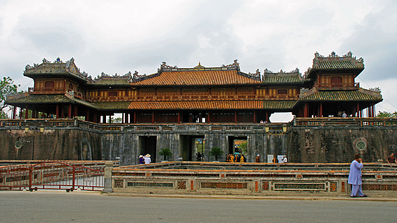
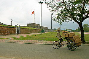
Entrance to the Imperial City
I WALKED across the Trang Tien Bridge, one of two bridges crossing the Perfume River in the middle of the Central Vietnamese city of Hue. There were two lanes of traffic crossing the bridge in either direction, but the number of lanes doesn’t mean anything in a swarm of motorbikes. Separated from the road was a walkway which I could safely cross with my group amongst the tight pack of pedestrians. The river was a pale brown colour opaque with grey silt to match the overcast sky above our heads. I’m not sure if it is always this colour, but the water was well within its banks and probably at a normal level for this time of year. The occasional dragon boat ambled through the calm water beneath the bridge.
City of Hue |
We had arrived in Hue just a couple of hours earlier, travelling south from Hanoi overnight on the Reunification Express. It was a train dedicated to the reunification of North and South Vietnam a couple of decades ago after the war. The border between north and south had been a little north of here.
Once we had crossed the bridge, we followed a footpath separating the busy road from a peaceful park at the river’s edge. The park was fenced off, but there were a few stalls along the footpath merged into the trees. Each stall was in the open air and selling either plants or animals. The plants were unusual local species looking very healthy in the tropical climate. The animals were all in small cages apart from the fish which were in clear plastic bags. They were all hanging either from the fence, or from the foliage of the trees above our heads. It seemed very strange to see the branches of trees with plastic bags full of water containing colourful fish swimming inside. It reminded me of my carnivorous plant collection back home, especially my nepenthes collection with their large water filled pitchers which would attract small animals to drown and dissolve. The fist in these bags were alive and well though, and fortunately it wasn’t a windy day.
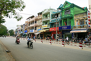
A row of colourful tall and narrow shops towered above the other side of the road. A striped barricade cut the road off from the wide footpath to create a wide pedestrian access area, and amazingly it was relatively free of parked motorbikes and other detritus so common here.
Artist under a tree |
We passed a break in the park, where cobblestone paving created a large courtyard in the trees to the river. A two level pagoda stood in solitude about half way to the river. This was where the king’s boat used to be moored, and where dignitaries would moor their boats to visit the emperor.
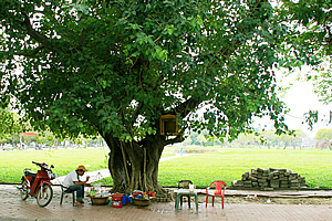
At this point we crossed the road and followed a side road heading away from the river. It was lined with old fig trees with very thick trunks on either side. Although the trees weren’t very high, their gnarled trunks indicated they must be at least a couple of hundred years old. An artist sat painting under one of these ancient trees. He was painting the scene of the park extending out past him and of the large stone building with the huge Vietnamese flag towering above the building. The artist had numerous paintings he had created displayed on small stands around the tree.
Entrance to the Imperial City |
Another tree had a man sitting cooking sausages on a small gas burner. His motorbike sat parked behind him. He had numerous pots and pans and gas canisters strewn out around the tree. He was lost in his own world concentrating on his cooking efforts. Was he doing this to sell the sausages perhaps? Or was he a homeless man cooking himself a meal? Or was he perhaps a local tourist exploring his own country on a budget? Who knows?
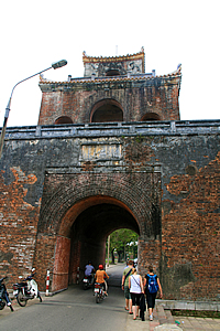
The trees abruptly stopped and the road narrowed and crossed a stone bridge spanning a huge moat, some one hundred metres wide fed by the nearby river and encircling a stone wall. The wall surrounded the imperial city, two kilometres wide and two kilometres back. The road was rather treacherous now with no footpath to cross it. The black water filled the moat, but thick weed covered about half of the water especially on the wall side. Had this moat been completely covered in weed before the flood two weeks ago?
The moat ended in a three tiered tower in the wall with an arched entrance going through it. The road now became even narrower. We had to look behind us to make sure there were no vehicles coming, and then we would pass through the tunnel close to the edge in amongst all the motorbikes and get to the other side hopefully before any large vehicles would come through. Paranoid that may sound, but seconds after we passed through, a truck barely smaller than the tunnel hurtled through behind us.
We had entered the imperial city. This used to be the centrepiece of Hue from when it became Vietnam’s capital in 1802 until 1945 when Hanoi became the capital under communism. Construction of the imperial city commenced in 1804 under the emperor Gia Long. It was designed under the guidance of Vietnam’s top Confucius geomancers. The city over the years had developed its own culture adapting to the harsh climate of very hot days in the summer dry season and ceaseless rain in winter.
Heavily laden cyclo |
The road continued in the same direction, now with a wide path on either side made from rectangular pavers. We followed the right hand footpath for a few metres to a corrugated iron roofed gazebo structure sheltering four cannons underneath it. The roof was held up by dark rusty circular columns, six wide and three deep. At the base of each column was an interesting shaped footing. Each cannon had a low wrought iron fence around it and a frame intricately carved. The cannons themselves were very plain. The shaft of the cannon would have been wide enough for me to have slithered into, but there was no way that I was going to do that.
A man rode past on a cyclo with numerous large boxes in the passenger seat from the footrest all the way up almost high enough to completely obscure his vision. He was obviously on a mission to deliver these boxes somewhere. The contents of the boxes must have been very light as the cyclo appeared to be massively overloaded.
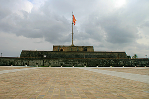
Cot Co |
Once finished posing in front of the cannons, we crossed the road and walked along a large cobblestone paved area along the wall. We walked until we reached the Cot Co - a large stone building with the Vietnamese flag on top. The four corners of the building had an elaborate five light street lamp. The mast itself could have passed as an elegant ship’s mast with the rigging holding it in place. The flag was gently flapping in the slight breeze. I had never seen such a large flag before. The flag itself had an orange background and a yellow star in the middle. The structure supporting the flagpole was pretty plain, a flattened three level pyramid with a row of white and blue glazed pots with trees growing in them.
Outside the Ngo Mon |
We walked across the citadel passing the flagstaff, before walking along another path heading directly away from the flagpole to another building where we stopped for photographs before heading towards it.
The construction was very intriguing with beams and framework sticking out of the building as if it were still under construction. The lower level was grey stone – probably marble. The upper two levels were timber. A group of Buddhist monks with shaven heads wearing brown and yellow, characteristic of the Mahayana monks, were entering the building.
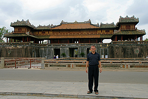
Ngo Mon |
Once across the road, we crossed a stone bridge going over a second moat that surrounded the buildings. This moat had dirty greenish brown water and lily pads floating over about half of the surface. Lush vegetation surrounded the buildings and moat. The bridge was solid stone apart from a two metre wide circular culvert connecting the pools of stagnant water on either side.
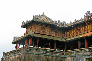
Now we were getting closer to the Ngo Mon building, the detail was showing up a lot clearer. This was the building where the emperor came out onto the balcony to deliver his speeches. The timber of the building was in remarkable condition stained in yellow browns and red browns in intricate patterns. The roof seemed to be made from logs, but had amazing marble carvings on the ridges of the roof. These carvings were perhaps white in its heyday, but centuries of rain and termite damage had eroded the soluble metamorphosed calcium carbonate brickwork into rough grey stone.
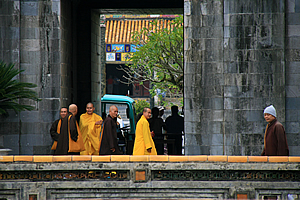
Monks entering the Ngo Mon |
The tower also marked the entrance into the Purple Forbidden City. This was a city within a city. The inner city itself had a perimeter wall with a circumference of two and a half kilometres. During the reign of the Nguyen emperors, only the emperors, their concubines and a few close to the emperor were allowed to enter. Anyone else entering the Forbidden City was executed. Those days were long past, so we could freely enter.
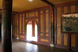
We walked through the arched entrance and climbed a wide staircase up the back of the building. There we entered the middle level and saw amazing detail in the carving and staining of the timber beams and columns especially near the ceiling. Some of the columns were supported by three large planks with planks of wood across them holding them together. They were in quite a regular array and I couldn’t work out whether they were there as part of the original design, or whether they had been added later as the structure had weakened over time. That I did not know, but I realised the supports had been there for quite a long time. Old paintings of different views of the palace adorned the dark walls. Actually this level had few walls in it as it was open plan to allow the king to deliver his addresses. There were a number of narrow sliding doors that could close the room in if needed. The level above us was completely walled though.
The intricate decorations in the temple |
To the right hand side of the floor was a huge bell hanging from the ceiling and coming down to thigh height. It was pretty plain in structure, cylindrical and domed at the top. It would have weighed a good three hundred kilograms and it was intricately carved on the surface.
Danh my tour leader explained some of the intricate carving around the building. The balustrades of the railings around the balcony were carved to match different symbols alternating between dull orange and dull green. This included the now familiar sun symbol, two circles close together in parallel with seven narrow members between them with horizontal lines through it and vertical pieces between the lines in certain locations creating a very interesting pattern. I had seen these lots so far this trip, but now I understood what it was about and why it was used here so much.
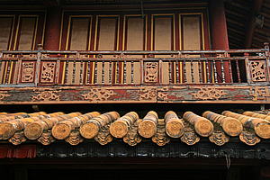
Roofing decoration |
A high wall extended out of either side of the building, capped with a plain triangular shape along the top, no doubt to disperse rain water to minimise erosion. Whether that was the intent or not, it certainly worked very well. A path followed parallel to the wall around the complex.
The roofing was very intricate. It had a layer of orange wood with face like symbols carved into the end of each piece. Above that were small round logs spaced about one and a half widths apart. Each log had a sun symbol carved into the end of it and was strapped into the roof with tight leather straps. No detail in this building had been spared. The carvings along the ridges and corners of the roof were pretty abstract, but they seemed to represent dragons and seemed to have stones set in them. It was hard to tell though.
Inside the temple |
The view from the front of the tower showed the large courtyard we had crossed, and the moat not far below us. Three bridges crossed the moat with the spaces in between perfect squares. Beyond that was the road we had passed, but I was pretty sure this was only recently created.
Beyond the vast courtyard stood the large three level square pyramid with the giant flag flying above it. It looked quite a lot taller from up here. The wind had died though, making the flag limp. Yet it remained hanging as a distant reminder of the empire this city had once controlled.
<< Previous | Next >> |
|
||
About this Page
|
||
|
|
|
Where is Walkabout Jeff? |
|
|

|
|
What is happening in Walkabout Jeff's hometown?
|
|
|

|
|
Who is Walkabout Jeff?Any normal person's idea of going out involves going to the local pub for a drink with a few mates. Walkabout Jeff isn't normal.
|
|
|

|
Follow Walkabout Jeff |
|