--- Archive files ---
Home > Travels > Kinabatangan > 2 |
Downstream by Longboat into the Jungle
BEFORE highways were sprawled across Borneo, the most efficient means of travel involved either taking a boat along one of the major rivers, or by walking through the vast dense jungles sprawled in between them.
Kinabatangan River |
After two hours of siesta with our hosts at Batu Peteh, we returned to the main community building. From there we climbed down the wooden stairs to a pontoon at the edge of the Kinabatangan River. There were two very narrow longboats without a roof. We climbed into one of them and sat in the wooden slats crossing the bottom taking care not to tip it over. We put our lifejackets on as the two drivers came down and started the small outboard motor. One of the drivers was a middle aged man. The other was Siamet, a young man who will be our guide for this trip.
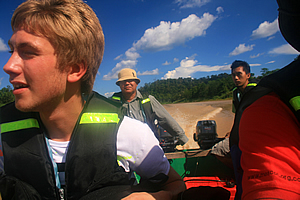
Travelling in the longboat |
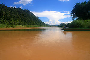
We took off and started heading downstream, making very good speed over the almost opaque brown water. It was the light brown colour typical of a river in flood. I wasn’t sure if this was the river’s permanent colour, but it seemed to be flowing rather high.
My tour leader Richard explained that in the dry season the river is sometimes so low that we sometimes have to jump out and push the boat. The water was quite high today so there was definitely no need to climb out of it. That was fortunate because hidden in the murky waters is the potential to encounter the salt water crocodile and the endemic Borneo river shark.
The Kinabatangan River is the second longest in Malaysia, at 560 kilometres long. Its headwaters are in the mountains of south western Sabah and it flows roughly north eastward to the Sulu Sea just to the east of Sandakan.
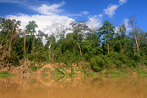
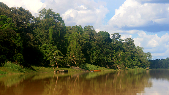
Bank of the Kinabatangan |
As we rounded each bend, there was a large clear silt banks on the inside corner. The grassy fields quickly gave way to palm plantations. The banks were loosely vegetated indicating the river does rise a lot higher at times during the rainy season. The palm plantations quickly gave way to lowland jungle. We saw the occasional white heron foraging at the waters’ edge, and the occasional fisherman in a small longboat catching his dinner. Puffy cumulous clouds now stood overhead though doing nothing to block out the very hot sun.
By now we had entered a large reserve of 270 square kilometres of protected forest over the river’s lower reaches. The deforestation over most of Borneo has been absolutely rife, so it was good to be within such a large preserve.
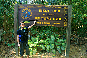
At the eco camp entrance |
About half an hour after reaching the start of the jungle, we reached a jetty. The boat pulled up to the pontoon. Once tied up we climbed out and followed a stairway to the top of the bank. We grouped under a large sign and took off our life jackets giving them to the boat driver to store in a nearby small shed. It was very peaceful here. To my surprise though, I didn’t see any animals. I would have thought the late afternoon jungle would be full of them.
The sign read: “Rikot Kou – Kem Timbaan Tungog. Welcome to Tengog Rainforest Eco-Camp”.
Siamet led us into the jungle, following a boardwalk which soon changed to a gravel track meandering its way between the huge trees. The temperature had cooled from the steamy tropical midday heat that had sucked all the energy from us, now making for a very pleasant walk through the jungle.
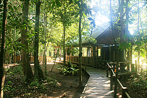
Eco camp in the trees |
After about ten minutes’ walk we suddenly reached a small lodge made from dark ironwood, painted in camouflage dark green and bluish grey roofing. The first thing I noticed was the lodge had been built around the trees. There were a couple of buildings with few small trees growing right through them. The holes where the trees grew through were lined with rubber to protect them. Obviously here the trees have the right of way of any construction.
Between the buildings were several levels of veranda built around the trees. There were holes in the decking to allow the trees to come through. Each level had plenty of seating and good safe railing. One staff member was sweeping leaves at the bottom level. Past the lower level was a large oxbow lake covered at this end in some form of South American weed which had made its way here. This was Tungog Lake. There was a small jetty. A couple of boats were out in the lake in an attempt to get rid of the weed. Richard explained the weed did not have any predators, so it grew completely out of control here strangling the lake.
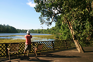
Deck over the lagoon |
The building at the top of the decking was for the staff, mainly for cooking facilities. The building at the other side from the entrance was the dining hall. We were led along a wooden boardwalk towards the sleeping huts in the forest. The first hut we passed was the bathroom, with environmentally friendly showers and toilets. Beyond that were a number of Scandinavian style A framed huts elevated off the ground. A two tier stairway elevated to the deck on the far side of each hut. I was allocated the second of these huts.
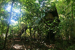
My hut |
We climbed up to our hut. All the timber was unpainted. The roof was overhanging in a similar fashion to the visitor centre we had visited at the bottom of Mt Kinabalu a couple of days ago. This was not quite as angled though. A two way French style door with woven grass coverings occupied the middle of the latticed gable front.
The huts on either side of us were barely visible through the thick jungle foliage. I couldn’t see who was on the other side. Inside the hut was two thin mattresses for us to sleep on with a red patterned blanket and a set of sheets on each, and a mosquito net to keep all the insects out – something I’d come to very much appreciate when night will fall.
We had arrived deep in the Bornean jungle, away from civilisation just like the early explorers would have done.
<< Previous | Next >> |
|
||
About this Page
|
||
|
|
|
Where is Walkabout Jeff? |
|
|

|
|
What is happening in Walkabout Jeff's hometown?
|
|
|

|
|
Who is Walkabout Jeff?Any normal person's idea of going out involves going to the local pub for a drink with a few mates. Walkabout Jeff isn't normal.
|
|
|

|
Follow Walkabout Jeff |
|