--- Archive files ---
Home > Travels > Titicaca > 1 |
Arid Highlands of Peru
THE COLD morning in Cusco dawned gloriously clear. My group had an early start today heading out of the old quarter to a bus station. From there we caught a bus heading southward 462 kilometres along the highway to Puno on the shores of Lake Titicaca.
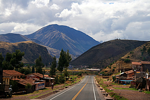
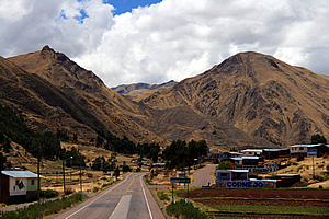
The road out of Cusco |
The bus was double decker, and I was fortunate enough to have a front seat on the top level, from where I had excellent viewing of the spectacular landscape as we ascended into the Andean mountains heading towards La Raya Pass.
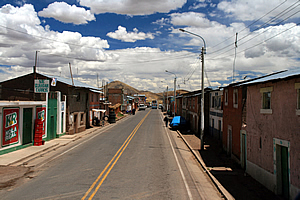
We frequently passed through small villages. In each case the entire village ran along the side of the road with no side streets. There were quite a few people sitting outside the houses on the edge of the road seemingly oblivious to the huge buses and trucks ploughing through at great speed. Another bus hurtled along the road about two hundred metres ahead of us, and would continue to do so until we got to La Raya.
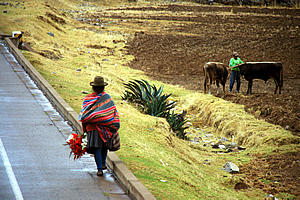
Hitchhiking woman |
In between the villages we saw numerous people herding goats or alpacas, driving carts, and quite a few people hitch hiking. Curiously a lot of the hitch hikers were women wearing old fashioned Peruvian woollen clothing and funny black bowler hats over their double braided hair. There were quite a few small vehicles on the road as well, all getting out of the way of the huge buses hurtling past.
Puffy cloud now covered the sky enshrouding the highest peaks at around 5200 metres above sea level. The valley was narrowing into a gorge where the river had eroded deep in the rock following the major ice ages past. The road was now following a railway line no doubt heading towards La Paz. The occasional blue Peru Rail train similar to those we had seen whilst hiking the Inca Trail to Machu Picchu passed us.
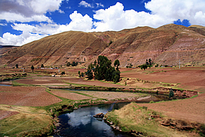
River through arid highlands |
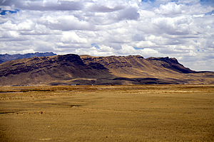
Soon it became apparent that we were getting very high. We had been constantly travelling on a gentle incline since leaving Cuzco. The farmland gradually became desolate having changed to appear subalpine and the air in the bus started feeling rather thin. In fact I was surprised the bus was performing so well at such high altitude. Perhaps the engine had been specially tuned for the thin air at this altitude.
The mountains on either side were steeper with obvious peaks forming at their summits now. The cloud was starting to clear letting blue sky through. The mountains had steep gullies often filled with scree.
Village in the mountains |
One farm had terraces built into the hill, created by the Inca five hundred years ago and still in use by the farmer as natural fencing and erosion control. The occasional village dotted the countryside, but unlike the villages we had passed on the main highway back towards Cuzco, these were quite some distance away from the main road. Occasionally we passed a dark blue lake. I guessed these lakes were streams artificially dammed to provide a water supply at this otherwise desolate area.
Here the road steepened as we made the final ascent towards a pass still unseen ahead of us in the rounded glacial valleys. It was getting quite desolate here, but I was surprised there were still houses up here and farmers looking after their stock.
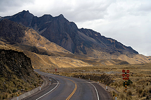
Mountains near the pass |
Ahead of us stood a large stony mountain with large scree slopes in between its precipitous bluffs. We crossed the railway line and continued towards the pass now finally clearly visible. The gradient started to lessen and the cloud partly cleared revealing quite a dark sky overhead.
Just ahead of us was the pass where I could spot some activity with a small market stand. The bus pulled over to the side of the road.
The market contained several brightly coloured stalls occupying the side of the road. Beyond the stalls stood a dark brown sign saying “Welcome to Les Desea Centro Artesanal ‘Abra La Raya’ Alt 4,338 M.S.N.M. Puno-Peru”. We were 4338 metres above sea level, half the height of Mount Everest.
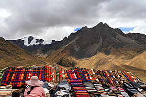
Market at the pass |
Stalls of brightly coloured merchandise blending in very nicely with the rocky mountain peaks towering behind made the stop worthwhile.
The pass marked the end of the Cusco area and the start of the Puno province. Any streams descending from here eventually make their way to Lake Titicaca where I was heading today.
Once back on the bus, we set off towards Lake Titicaca. It quickly became apparent that the countryside was a lot drier on this side of the pass. We would occasionally cross a mirror smooth dark river, but otherwise it was very arid here with the grass very brown. This was a sure sign we were approaching the Atacama Desert, the driest place on Earth.
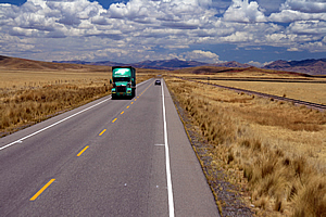
Long road to Puno |
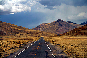
Once we had completed our initial descent from the pass, it was also obvious there were few houses here. The farms were very large. The towering mountains that had embraced the pass quickly morphed into sandstone hills under the distant backdrop of the main divide of the Andes still a long way ahead of us. These dark snow covered mountains stood around six thousand metres high.
The road was in excellent condition having been freshly sealed only in the past couple of years. The railway line we had followed since Cuzco continued to run parallel to the road through the remote farmland.
Ayaviri |
Almost an hour passed after leaving the La Raya when we finally reached the first small town - Ayaviri. Here the road divided into two with a large island in the middle. In the middle of the island were realistic statues of a large white sheep and a large brown bull. A scruffy dog was drinking out of a large puddle by the side of the road.
It only took a couple of minutes to go through the town. We crossed the railway line and continued through the rather barren countryside. Here the surrounding hills took on very interesting formations. There was obviously a hard layer of sandstone at the top creating a line of bluffs across the crests of each hill. Below the crests were lines marking the stratification of the sedimentation millions of years ago when all of this was under the Pacific Ocean before it was thrust to its present position at 4000 metres above sea level.
Uplifted mountains |
We crossed a small placid river almost perfectly reflecting the hills, clouds and sky in the dark cold water. Now that we were starting to reduce altitude, we passed through several small villages along the side of the road. The houses were very ordinary with silver corrugated iron roofing and absolutely no landscaping.
The farms were becoming more frequent here even though the land was still parched. The buildings in these farms seemed to be in poor condition though with a couple of barns having partially collapsed thatched roofing.
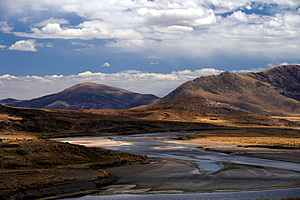
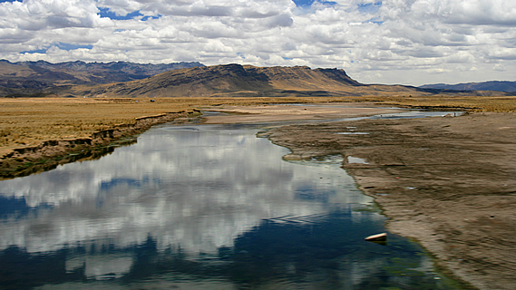
River flowing towards Lake Titicaca |
The valley grew wider yet the hills on either side of it became steeper and with rows of bluff protruding from their crests due to a hardened layer of strata. The river we were following was becoming quite substantial now. The road was in fairly poor condition now with a lot of potholes no doubt created by all the trucks that we were passing. There were a few large burn-offs adding to the haze now in the sky.
Although we were losing altitude, the land remained parched. The river dug quite deep into the valley floor indicating recent tectonic forces had been uplifting this area. The surrounding hills were getting higher now, or perhaps the valley was continuing to drop.
Road through the arid mountains |
Soon the valley widened and the river changed from the slow flowing gorge in between large cliffs to a sluggish braided river ready to meet its delta. The river meandered from side to side of the valley, often cutting very close to the road. It would only take one severe flood to erode the road into the river. At one of the bends just before a village there were numerous people swimming in the cold water.
Two and a quarter hours passed after leaving La Raya when we suddenly arrived in Juliaca. This large town seemed very poor in comparison with the other cities we had travelled to in Peru so far. The people seemed poor and they all rode either large reverse tricycles with goods or people loaded in the large trays in front, or those who could afford it would drive the small single person three wheel cars. It reminded me of a very slow version of Ho Chi Minh City. It was a very run down city.
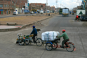
Juliaca |
The main road widened into two lanes going either way with a good fifty metres in between overgrown with weeds. It was a very neglected city. There were numerous trucks parked in the city. This must be where a lot of truck drivers lived.
Upon leaving the city, the hills had reduced to large rocky mounds. Stone walls marked the boundaries of the paddocks, but there was little livestock on the arid land.
The plains in between the hills were encrusted in salt, indicating they had been submerged at some stage. This could only mean one thing. Lake Titicaca wasn’t far away.
<< Previous | Next >> |
|
||
About this Page
|
||
|
|
|
Where is Walkabout Jeff? |
|
|

|
|
What is happening in Walkabout Jeff's hometown?
|
|
|

|
|
Who is Walkabout Jeff?Any normal person's idea of going out involves going to the local pub for a drink with a few mates. Walkabout Jeff isn't normal.
|
|
|

|
Follow Walkabout Jeff |
|