--- Archive files ---
Home > Travels > Tweed > 4 |
Sacred Pinnacle in the Caldera's Centre
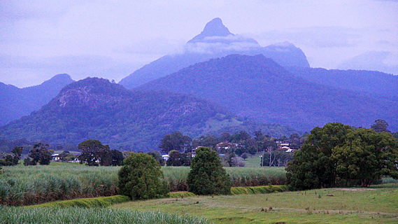
THE MORNING dawned overcast with low cloud enveloping much of Mount Warning. The car park at 445 metres above sea level was not high enough to be above the thick humidity that pervaded the crater. Although it was early morning there were already a lot of cars parked here. Many people hiking the mountain climb in the small hours of the morning to watch the sunrise from the summit. This morning’s early riser climbers would have no such luxury today with the thick cloud overhead. At this stage there seemed little chance of me getting any view from the top either with heavy rain to begin falling from tonight. View or no view, I needed to climb the mountain now whilst I still had the chance.
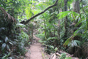
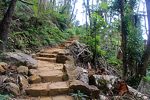
Start of the track through the forest |
Fortunately the four and a half kilometre track was open. Just under two years ago, the dying remains of Cylcone Oswald caused serious damage to the track. The damage was so severe much of the track needed to be rebuilt from scratch. A huge volume of fallen vegetation needed to be cleared to rebuild the track. This all needed to be cleared by hand with the workers having to hike up to 5 hours each day to where they were working. Forty tonnes of gravel and track materials were brought in by helicopter for the repairs. The track was reopened eight months after the storm. Fortunately this meant the track was almost new and in very good condition.
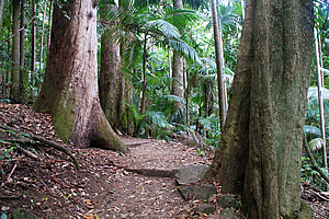
Big trees |
The staired track passed through thick rainforest with tall trees and Piccabean palms. This was part of a forest corridor extending westward from the Wollumbin National Park into the Mebbin National Park across to the crater at the Border Ranges National Park to give wildlife free access between the mountain and the crater. The track rose in a set of stairs across the back of a very steep gully. If this was going to be the terrain at the base of the mountain, then what was it going to be like further up where mountains are normally steeper?
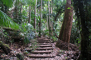
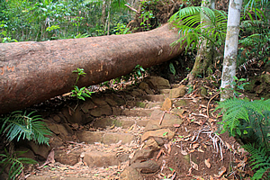
Stairs up the mountain |
A sign at the bottom advised that Wollumbin (Mount Warning) is a sacred place to the Bundjalung people, and only specifically chosen people are allowed on the mountain. To the Bundjulung, the mountain is a significant place of cultural law, initiation and spiritual education. Only specifically chosen people are allowed on the mountain. Despite that, over 100,000 climb the mountain every year. Another sign warned against starting the climb after midday in winter. Apparently people have become lost on the descent when they have been caught out in darkness.
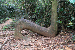
Strangely bent tree |
I started the climb through the rainforest climbing the stairs quickly gaining altitude. It was not long before the first of the climbers who had gone up to see the sunrise passed me hurrying down the mountain. They had not seen any sunrise as the summit had been enveloped in cloud.
The track eventually reached a hairpin bend and doubled back over the steep gully. A short distance followed before I reached a clearing with a small metal base with a sign saying this was the first helipad for air rescues. It was located 1.2 km from the car park at 724 metres above sea level. People obviously get injured here and need to be rescued.
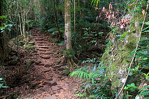
Track ascending the forest |
I continued following the track as the rainforest gradually changed to tall cedar dry forest. The terrain was getting steeper. At the bottom of the gully the track passed a warning sign indicated as the half way mark between the car park and the summit. The sign said if it was winter and it was after 1:00 then you should be heading back because people returning in the darkness often become lost. Perhaps this was due to some spiritual aspect of the mountain. I was still only 758 metres above sea level here (300 metres above the car park), so the remaining track will have to be a bit steeper to rise the remaining 400 metres to the 1150 metre high summit.
Track ascending the forest |
Mount Warning was named by Captain Cook as he sailed along the coast to highlight the dangerous reefs he encountered. From there the mountain had been a dominant peak. That being said I was thinking it was named Mount Warning due to all the warning signs along the track.
There was now a steady stream of people heading down from the summit, none of whom had seen the sunset as the top was enveloped in cloud. The people passing me were a lot slower than the ones who had passed me earlier. They had probably all left at roughly the same time, but the fit ones had passed me at the bottom of the mountain. Now the people passing me returning down the mountain were getting rather slow. One middle aged woman was carrying her boots getting her white socks very dirty on the track.
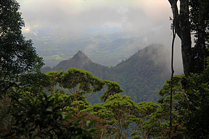
View over the surrounding hills |
The forest began to thin with trees becoming lower as the terrain began to become exposed. In places the forest parted enough to provide a view down to the jagged peaks of the hills below. The track became rocky and ahead of me was a towering vertical cliff. The track turned a sharp hairpin bend just before the start of the cliff and continued backwards and forwards through the low scrubby forest across the front of the mountain in between two cliffs. The altitude gain was now rapid with with each switch back reducing the distance between the two cliff faces. This could only mean I was getting closer to the summit.
Rising above the forest |
Eventually the graded track ended just past the fourth helicopter pad at a wooden seated area. Here the altitude was 1016 metres above sea level, so there wasn’t far to go to the top. There had been other helipads at 785m and 902 metres respectively since passing the half way mark.
From here a chain followed a cleared gully in between stunted scrub headed straight up the side of the mountain. There was another warning sign indicating the steepness of the track and not to proceed if there is a thunderstorm. I imagined there would be a lot of lightning strikes at the summit during the severe storms often experienced here. Any bolt of lightning that hits any part of the chain would electrocute anyone who happened to be holding it to get themselves up or down.
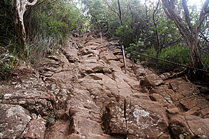
The chained gully |
There were plenty of people heading up and down the chained gully. I began my ascent. Despite all the warning signs and stories I heard it wasn’t too difficult at all climbing the gully. There were plenty of holds and outcrops that I could hang onto and step on. The chain made it a fairly steady climb. It was a lot easier than some of the other climbs I have done in the past.
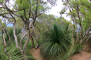
The gully ascended the ridge towards the summit, with a couple of kinks. Eventually I could see far enough ahead to where the slope began to ease off. There was only one huge boulder that was a little challenging, but otherwise the climb was easy. Finally the slope began to ease off and the chain ended. The terrain began to level off into a moderate slope amongst strange grass trees and other windswept scrub, some varieties only found in this tiny area around the summit.
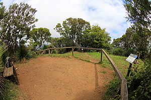
Clearing at the summit |
The track levelled off on a small grassy area surrounded by scrub. This was the summit at 1159 metres above sea level. Like many summits I have climbed in the past, the summit was rather undramatic being a flat area. Most of it was fenced off as the top of the mountain is home to some plant species found nowhere else on Earth. It is a tiny sky island which needs some protection from the hundred thousand plus people climbing every year.
Here a man had some incense burning. Although his hair had been cut short, he was obviously one of the local hippies. He had climbed the mountain much earlier this morning for the sunrise and has since lingered at the summit for about five hours waiting for the cloud to lift.
Track around the summit |
Specially chosen Aboriginal people would have no doubt climbed the mountain for thousands of years. The first documented successful climb to the summit was by botanist Michael Guilfoyle and his party of four who took three and a half days to reach the summit in 1871. He recorded “When we reached the top we were so enchanted with the glorious view that we quite forgot the inner man, remaining on top all night without food.”
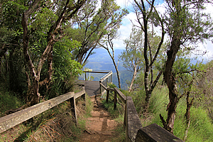
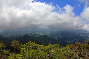
Despite the trees concealing the view from the summit, there was a boardwalk going around the summit to several viewpoints. There was still a lot of cloud around, but much of it had lifted to above the mountain. There was still some cloud below me, but amongst the cloud I could see out to different parts of the crater.
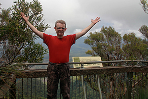
Achievement! |
There was quite a group of people at the summit, seated at the various lookouts. Some stayed for a short while. The hippy burning the incense had been there for a good five hours patiently awaiting the clouds to lift, but he eventually gave up and headed back down the mountain. Shortly afterwards the clouds did begin to lift.
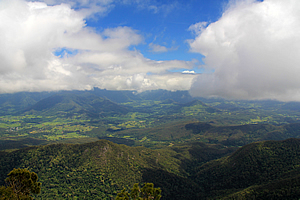
From the centre of the crater the walls seemed rather indistinct. The sides of the crater were roughly the same elevation and the walls were facing directly towards me, looking surprisingly featureless. It’s an interesting illusion that comes from being in the middle of a caldera. Although undramatic, the Tweed Volcano is the world’s most preserved extinct shield volcano.
View through the clouds |
Mount Warning was the fiery heart of the volcano rising to more than twice its current height at around 1900 metres above sea level when it finished erupting about 23 million years ago. 3200 cubic kilometres of lava had created the volcano. The huge shield volcano spread lava out over huge distances to the coast and back towards the surrounding mountains.
The mountain itself was formed at the end of the eruption when a relatively cool weather resistant lava erupted filling the plug inside the volcano. The mountain is made of tough trachy-andesite, rhyolite and syenite. After the eruptions stopped the mountain continued to be pushed upwards for some time.
View of the crater |
Today the mountain was living up to its name. The local Aboriginal word “Wollumbin” means “cloud catcher” or “fighting chief of the mountains”. Whichever name it means, it certainly was living up to it today.
The mountain contains a wide variety of plants, animals, insects and fungi. Apparently around 200 of these species are found nowhere else on Earth outside of the Tweed Volcano area. Some of these could very well be unique to this mountain.
Looking towards the coast |
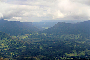
Below each lookout the mountain dropped away almost vertically down into the rolling hills of the Tweed Valley. The valley widened with the meandering Tweed River snaking its way towards the coast. About half way down the valley was Murwillumbah where I had started from this morning. At the mouth of the river was the Tweed Heads.
The river valley was filled with sea water during interglacial periods between ice ages turning the valley into wetlands and depositing coastal sand. At this point is where climbers watch the sunrise. During winter this is the first point on the Australian mainland to receive the sunrise. During summer Cape Howe in southern New South Wales is the first place to see the sun. Today the first place to see the sun would have been somewhere distant along the coast away from the cloud.
Vegetation around the summit |
I began the long descent down the mountain. Descending the gully with the chain was a little slow, but again easier than I had initially thought. Eventually I was back down on the track heading back into the gradually easing terrain through scrub which gradually became cedar forest then eventually rainforest near the bottom of the valley.
I had conquered the sacred mountain at the centre of the volcano.
<< Previous | Next >> |
|
||
About this Page
|
||
|
|
|
Where is Walkabout Jeff? |
|
|

|
|
What is happening in Walkabout Jeff's hometown?
|
|
|

|
|
Who is Walkabout Jeff?Any normal person's idea of going out involves going to the local pub for a drink with a few mates. Walkabout Jeff isn't normal.
|
|
|

|
Follow Walkabout Jeff |
|