--- Archive files ---
Home > Travels > Tweed > 3 |
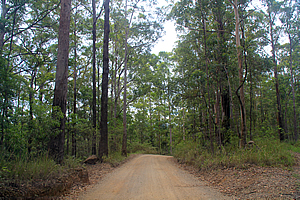
Dusty Road into the Caldera
THE ROAD around the outside of the volcano was narrow and winding, but at least it was sealed. 22 million years of erosion had created deep gullies radiating out from the crater. Heading back in the general direction of the coast from Nightcaps National Park I passed through beautiful farmland in between wooded rolling hills it was a rather remote place to behold.
Road over Mount Jerusalem |
Eventually I found a road leading over Mount Jerusalem, heading into a national park of the same name. The narrow road passed through more farmland before suddenly beginning an ascent through thick forest. It was not long before the seal ended and once more I was on gravel road. A large warning sign about no unlicensed or unregistered driving was allowed here. The fact that such a sign existed here wasn’t a good sign. I was apparently entering a rather remote area frequented by hoons.
The narrow winding road climbed the side of the mountain until eventually it levelled off at what I presumed to be the top of the ridge loosely marking the crater rim. A couple of gravel roads led from the main one, and fortunately a forestry sign was pointing towards Uki, a village I knew was based in the crater. If I keep heading towards Uki, then I was definitely on the right track to getting to better roads.
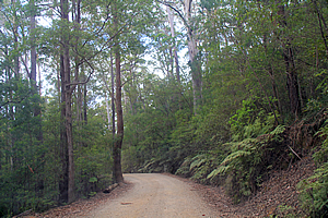
Road over Mount Jerusalem |
Eventually the road began to descend into what I guessed was the crater. The terrain on this side of Mount Jerusalem was steeper but fortunately the road condition seemed to be improving.
It was not long before the dominant peak of Mount Warning suddenly appeared across the valley. The mountain marks the centre of the volcano, where a huge plug at the end of the eruptions had formed and very slowly solidified underneath the volcano. In the 22 million years since the eruptions, all of the soft rock has worn away leaving the plug standing dominant.
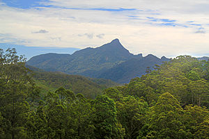
Mount Warning |
Eventually the road reached the bottom of the valley. The narrow flat valley had dairy farms where cows grazed on the thick grass fuelled by the fertile volcanic soil. The road quickly ended at an intersection of a sealed road. Turning right I was heading towards Uki, where I reached after about ten minutes.
Uki sits under Mount Warning on the banks of the Tweed River, the main outflow of the crater meandering its way between the steep forested hills towards the coast. I followed the river upstream for a few minutes before reaching a junction to the Clarrie Hall Dam.
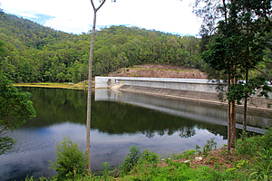
Clarrie Hall Dam |
The dam was built around 1980, blocking off the Doon Doon Creek to a depth of 41 metres. Over the summer rainy season the dam collects water from the surrounding hills. During the dry season the water is released into the Tweed River to prevent the river water from becoming too saline to drink where it is collected downstream to supply the local towns. The lower reaches of the river is tidal, so the fresh water from the dam pushes the saline water back towards the sea.
A bulldozed track followed the side of the lake, from where there were spectacular views of Mount Warning. The mountain is considered sacred to the Mooraing-Moobar Aboriginal people who once lived in the valley now flooded by the lake. They consider themselves the custodians of the mountain along with the Tul-gi-gin people of the northern Tweed Valley and southern Gold Coast and Goodjinburra people of the Tweed Coast. Together these were clans of the Bundjulung People.
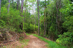
Track above the lake |
There were a few signs at the dam indicating some of the dreaming stories told by tribal elders passed down from generation to generation.
Historical sites such as a cave and numerous campsites and primitive tools now lie submerged beneath the placid waters of the lake.
The track roughly following the lake upstream entered back into the Mount Jerusalem National Park. The forest was thick but occasionally there were glimpses of the lake. At each ridge a side tracks followed the spur down to the lake. The dam had been heightened recently raising the water level to further flood the forested ridges. Each point was rewarded with spectacular views across to Mount Warning which hovered precipitously over the rolling hills.
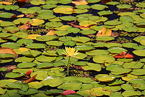
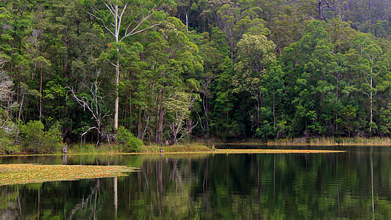
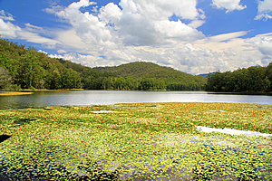
Lilies on the lake |
Water lilies grew in the shallows of the lake to about fifteen metres offshore where I guessed the lake was about five metres deep. Many of the lilies were in flower, some were a soft yellow and others were pink. Beyond the lilies the waters were clear. The banks of the lake were covered in scrubby Kangaroo Paw out in flower. Looking closer to the ground I also found some small irises in flower.
The lake occupied the long winding valley that the Doon Doon creek had once run through. It would have flowed down the forested valley in small cascades winding its way in between the rolling hills around the side of the crater. The crater wasn’t at all obvious from here. The erosion over this side of the Tweed Valley wasn’t as pronounced as one would expect to find in the inside of a volcano. Certainly to the untrained eye it wasn’t at all obvious that this was a volcano.
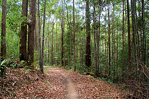
Track above the lake |
After two points the trail gained altitude above the lake through the tall cedar forest with no signs of descending back to it. Soon it became apparent that the track was just going further and further into the hills, possibly to meet the road I had travelled along earlier.
At some point I decided to return to the lake, back to the flooded valley of the dreamings. Back at the dam there were several boards giving dreamtime stories. One of these stories discussed the black bean that could only be eaten after careful preparation due to the toxins in it. Another story explained why the black wren has red feathers. It was the only bird to have been able to carry a killed black snake back to its tribal ground for burial. The story tells of the redness of the feathers being due to the blood bled from the killed snake. Stories such as these were told to give meaning, identity and a sense of place in an ordered world.
Lake |
It was from there that I headed down the Tweed River to Murwillumbah about half way to the coast. By this point the valley had opened out giving a spectacular view around the inside of the Tweed Crater. The mountains that I had crossed over today to the left of the valley seemed fairly regular, but the mountain range to the right towered high like a perpetual wave on the verge of barrelling. This range definitely looked like the inside of a volcanic crater.
The tops of the crater were covered in a thin layer of cloud, with mist descending from the cloud into the crater. This gave a real mysteriousness to these mountains which I will be exploring soon. Looking westward directly into the Tweed Valley between the ranges, Mount Warning stood dominant in the centre of the volcano. Although it had appeared ominous from the lake, from here it seemed even steeper with its sharp peak rising almost vertically.
Tomorrow I will attempt to climb Mount Warning.
<< Previous | Next >> |
|
||
About this Page
|
||
|
|
|
Where is Walkabout Jeff? |
|
|

|
|
What is happening in Walkabout Jeff's hometown?
|
|
|

|
|
Who is Walkabout Jeff?Any normal person's idea of going out involves going to the local pub for a drink with a few mates. Walkabout Jeff isn't normal.
|
|
|

|
Follow Walkabout Jeff |
|