--- Archive files ---
Home > Travels > Tweed > 2 |
The Big Scrub of the Nightcaps
VOLCANIC terrain is often very fertile, containing magnificent forests that are unfortunately sitting ducks for clearing into lush farmland. This creates conflict between the original forest and the indigenous people who inhabited it, and the progression of modern civilisation.
Rocky Creek Dam |
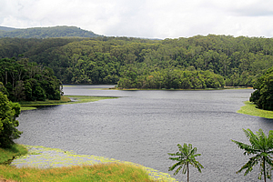
The road inland to the Rocky Creek Dam passed through farmland over the rolling fertile ridges of the flanks of the volcano. The winding road eventually reached the lake which supplied water to surrounding towns.
The dammed lake was surrounded by thick forested rolling hills gradually ascending towards the unseen crater rim. I followed the trail along the top of the large artificial dam towards a large spillway draining into the narrow valley below. Water weed occupied the first ten or so metres out from the shore, perhaps marking the contour of about four metres below the surface. Most of the lake was too deep for it to grow.
Boardwalk along Rocly Creek |
The hills surrounding the dam had been cleared farmland at the time when the dam was built in the 1950s, but has since regenerated back into a fully functioning rainforest.
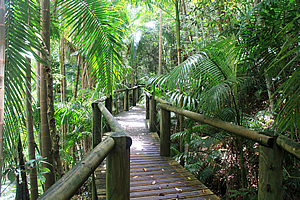
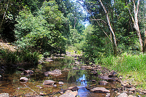
From the hill above the dam the trail followed a boardwalk above the steep ground in the piccabean palm forest. The boardwalk descended to a floating wooden bridge across a large naturally formed pond in Rocky Creek, the stream that flows from the causeway. Grasses and other water weeds were growing in what seemed to be a healthy ecosystem. The valley was closed in to the point that from here there was no sign of the dam upstream.

Rocky Creek Dam |
It was not until I had crossed over and was ascending a staircase on the other side that the tall stony slope of the dam came into view.
I returned back along the boardwalk and descended to the spillway. There was very little water flowing into Rocky Creek, probably just through a pipe beneath the expanse of angled concrete. I walked up the slope to the edge of the lake. Tall grass blocked off most of the view but there were a couple of gaps into the water.
Regenerating forest |
From the end of the spillway a four wheel drive track headed up the ridge. It joined another track heading towards the Big Scrub. The forest here was still relatively young having been cleared farmland up until the time the dam was built.
The wide track continued heading gradually uphill along the top of the fairly undefined ridge. After about twenty minutes it suddenly ended in a kind of cul de sac from where a walking track headed deeper into the forest.
Tall forest of Nightcap National Park |
At the start of the track was a sign “Welcome to Nightcap”. I was now in the national park.
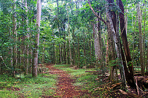
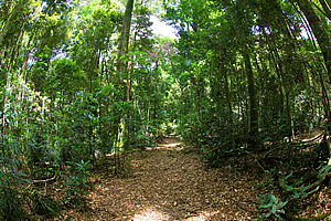
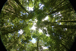
The bush suddenly changed from a young regenerating woodland into a more established forest of enormous trees towering into a subtropical canopy reaching a good forty metres above me. I suddenly felt very small crawling along the dark valley floor. By now the sun had come out, but it was still very dark where I dwelled.
Giant strangler figs were climbing the tall trees. The trees that weren’t being strangled by parasitic figs were covered in huge vines, some hundreds of years old. The roots of the trees were splayed out around the ground providing an enormous amount of strength.
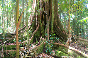
Big tree |
This was a remnant of the Big Scrub. Once a great forest of over 900 square kilometres covering from as far as Cape Byron up to the crater rim north of here and south to the Richmond River before white people came and began harvesting the huge trees for timber. Most of the Big Scrub was wiped out and converted to farmland. Only 1 percent remains. The volcanic soils were very fertile. Fortunately part of the Big Scrub has been preserved in the Nightcaps National Park, marking the southern side of the crater.
The Big Scrub had been home to the Widjabul people who had called it Bundjalung country. For over four thousand years they had respected the land which they had considered sacred to both themselves and to the animals. The elders have a saying –
BUNGJALUNG JUNGUN: |
BUNDJALUNG COUNTRY |
Tall forest |
The trail seemed to go quite some distance up into the mountain, but at some stage I turned back returning to the four wheel drive track and back a bit further to a junction where I continued following a new track steeply down to Rocky Creek downstream from the dam.
There was no bridge across the stream, so I clambered over the rocks and climbed the track on the other side heading back towards the dam. Upon arriving at the dam I saw the brightly coloured Nimbin Bus. It was very retro looking very 1970s and brightly rainbow coloured. It was packed full of young backpackers who had come for the “Nimbin Experience”. I will be heading there myself in a few days’ time, but I wanted to experience the natural heritage of the volcano first.
Rocky Creek |
From back at the dam I followed the 22 kilometre long gravel road gradually ascending deep into the park. The forest here seemed a little dry considering this is the wettest place in New South Wales. It was not long before I was travelling once more amongst the giant trees of the Big Scrub. The gravel road seemed to go forever eventually passing a campsite.
From there the road commenced a descent. To me this seemed a little strange with heading towards the edge of a volcanic crater I would have expected the road to continue climbing. Repentance Creek followed the road until suddenly crossing ahead at a ford.
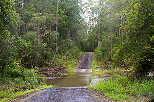
Ford over Repentence Creek |
Once over the low crest the road briefly continued heading downhill until reaching the entrance to Minyon Falls. The road had been very quiet all the way from Rocky Creek, but there were cars parked everywhere.
The car park stood beside a large picnic area from where a sealed track led towards the falls. Another rough track led down towards the bottom of the falls, but the sign said this track was 4.5 kilometres and quite difficult. It was getting towards the end of the day, so I didn’t have time to head down there and return before dark. I decided I would take the much shorter 50 metre track through the scrub to the top of the waterfall.
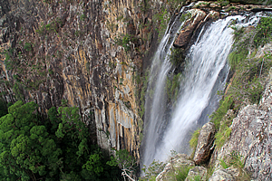
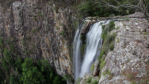
Minyon Falls |
The track became a boardwalk through the tea tree scrub elevated above the grassy undergrowth. I reached a large lookout from where there was a spectacular view of the nearby waterfall. The placid Repentance Creek suddenly plunged down the edge of a vertical wall of rock cut into the mountain into rainforest a hundred metres below. The wall of rock had almost no vegetation on it. The misty water fell silently into the canyon.
Immediately above the falls was a group of muppets fearlessly dicing with danger at the edge. Those of us on the platform just stood there in disgust hoping they wouldn’t fall over the edge to certain death.
Gorge below Minyon Falls |
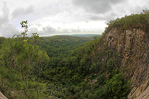
There was a group of people just visible at the bottom of the falls, having risen to the challenge of hiking the long trail down into the valley below.
Looking out down the canyon it didn’t seem obvious that I was at the edge of a crater with forested hills extending out under overcast skies. 23 million years of erosion had severely worn away at this side of the crater of the supervolcano.
There was a road heading steeply downhill into the crater, but it was very rough, so I decided to return the way I had come to explore more of the southern side of the volcano before finding another way into the crater.
<< Previous | Next >> |
|
||
About this Page
|
||
|
|
|
Where is Walkabout Jeff? |
|
|

|
|
What is happening in Walkabout Jeff's hometown?
|
|
|

|
|
Who is Walkabout Jeff?Any normal person's idea of going out involves going to the local pub for a drink with a few mates. Walkabout Jeff isn't normal.
|
|
|

|
Follow Walkabout Jeff |
|