--- Archive files ---
Home > Travels > Tweed > 1 |
Cape Byron Sunrise
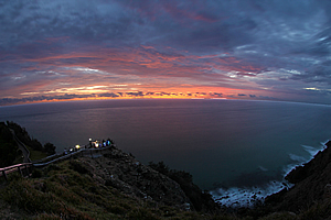
THE EASTERN sky was just beginning to lighten with the first hint of dawn, breaking the otherwise total darkness of the overcast starless sky. A crowd was gathering under the lighthouse in anticipation of the coming sunrise. Below the main lookout was a trail descending a spur to a couple of smaller lookouts.
First light at Cape Byron |
The roar of the breaking waves resonated from the surf below. In the darkness I could now the white froth of the breaking waves sweeping across the giant boulders lying far below me at the foot of the cliffs, generated by some distant tempest. Here the wind was almost nonexistent in the warm humid summer air.
I had doubts about whether the sunrise would be any good this morning. The sky overhead was overcast and the town of Byron Bay sweeping across the beach on the other side of the hill was enveloped in thick smoke from a bushfire further along the coast. A slight shift in wind could redirect the smoke in this direction blocking off the sunrise.
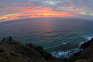
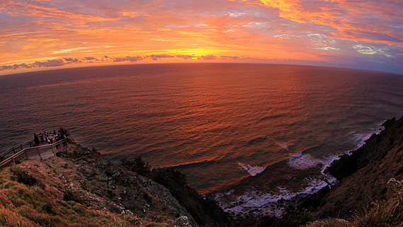
Sunrise |
Fortunately there was a break in the cloud over the horizon. This was exactly what I needed for a good sunrise. The crowd was quickly growing. Many of these people had been staying in the town and had walked up here.
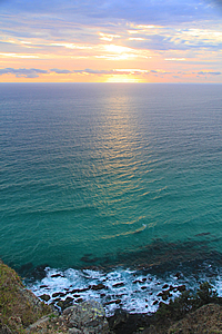
The sunrise did deliver. The clouds hovering overhead suddenly lit up a brilliant purple, then orange, illuminating the sea into crests of liquid embers.
The brilliance was short lived though. The fiery colours converged back to the immediate area surrounding the sun as the clouds changed back to dull purple and the sea a deep greenish blue. The sun then shone through a gap in the clouds turning the sea in front of me into a hotter fire of brilliant gold.
Looking north towards the fire |
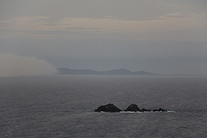
I could now see along the coast on either side. To the north were some more headlands and reefs in the distance. I could see the headlands, but the hills behind them were obscured by the smoke of a large bushfire. The smoke swept around to about two kilometres behind the cape where I was standing. To the south a long beach swept across to another point in the distance. The hills behind the point were obscured by the haze of the smoke.
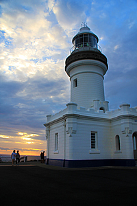
Behind me was the Cape Byron lighthouse, having stood here since 1901. It is Australia’s most powerful lighthouse with the light having a range of 50 kilometres. The two metre diameter lens weighs 8 tonnes and floats in a 360 kilogramme bath of mercury. It was the first lighthouse in Australia to use a mercury float system, rotating during the day to minimise any fire risk from the sun. The light was electrified from 1956, and completely automated in 1989.
Sunrise |
The lighthouse |
From the lookout I followed the trail around the coast along the clifftops. There were lots of steps and barriers to prevent people from falling off the edge of the cliff. It descended to a small lookout that had a sign saying this was mainland Australia’s most easterly point. The cape itself ran along a cliff running north-south, so without the sign it would have been hard to tell exactly which point was the most easterly.
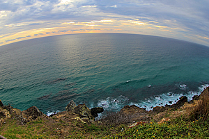
View from Australia's easternmost point |
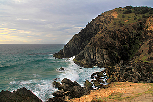
From the lookout the track descended towards a low headland jutting out southward into the sea. Upon nearly reaching sea level I reached a junction and took the side track out into the headland.
From the headland I returned to the track following some stairs around the next point to Little Wategos Beach where a few people were surfing in the otherwise isolated location. A small headland separated it from Wategos Beach where the track dropped down to the road beside which a number of people were camping. The track followed the beach and up the headland on the other side.
Australia's easternmost point |
Once over the headland the track diverted away from the coast heading through scrubby bush at the site of an old Aboriginal village.
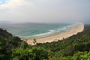
Once past the bush I reached Fisherman’s Lookout from where there was a spectacular view around Byron Bay. From here I was hoping to have a good view across to Mount Warning and other parts of the Tweed Volcano, but instead the view was obscured by smoke. Perhaps this was a reminder of this area’s origins. Around 22 million years ago a super-volcano had been created. The headlands of Cape Byron where I was standing was just one very small part of the giant shield volcano.
Byron Bay enshrouded in smoke |
The track descended to the start of Byron Bay village, at a place called the Captain Cook Lookout. It had been constructed several decades ago and since then the scrub had grown to the extent that the view was completely blocked off. With no view, I headed across the road to follow the track along Tallow Ridge following the other side of the headland back to the lighthouse.
The bush on this side of the headland was mainly tea tree with large native cycads growing on the forest floor. The cycads were a remnant of hundreds of millions of years ago when plant life was very primitive. Somehow they had survived unaltered for all of this time.
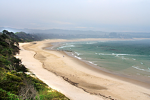
Looking south from the cape |
The track gradually ascended to a viewpoint from where I could see the smoke had approached and covered much of the beach. It was just a matter of time before the smoke will envelope the cape.
A little further along the track I could see the lighthouse perched at the top of the cliff, marking Australia’s easternmost point. From the lighthouse the cliff dropped very steeply into the sea, which was eating away at the eastern remnants of the great volcano.
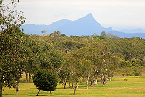
First glimpse of Mount Warning |
From the lighthouse I headed across to the far side of Byron Bay village. Fortunately the smoke had largely cleared, drifting away to the south. The cape stood dominant over the water, the end of a hard basalt lava flow from the volcano. In the other direction I had my first view of Mount Warning, the plug at the centre of the now extinct volcano, standing almost vertical above the surrounding hills.
This side of the volcano was all but gone, with only the headlands remaining. The rest of the coastal side of the volcano had completely eroded away into swampland and sandy beaches in between the hard headlands.
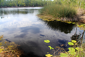
Lagoon at Tyagarah |
Before heading inland, I visited the swampland at some of the lakes in the Tyagarah Nature Reserve. A deep pool of crystal clear water occupied the area where once a stream had flowed through and the sea had created a dune that blocked it off. Over the years since more layers of dunes have formed as the coast moved eastward with the deposition of more sand. In this coastal wetland forest concealing small lakes there was no more evidence that a volcano had erupted here.
Only upon reaching the beach would I find headlands such as Cape Byron where all that was left of the volcano were the toughest of dykes that had so far resisted erosion into the infinite grains of sand lining the edge of the Pacific Ocean.
<< Previous | Next >> |
|
||
About this Page
|
||
|
|
|
Where is Walkabout Jeff? |
|
|

|
|
What is happening in Walkabout Jeff's hometown?
|
|
|

|
|
Who is Walkabout Jeff?Any normal person's idea of going out involves going to the local pub for a drink with a few mates. Walkabout Jeff isn't normal.
|
|
|

|
Follow Walkabout Jeff |
|