--- Archive files ---
Home > Travels > Tweed > 6 |
Loop where the two Volcanoes Meet
THANKFULLY all the local roads were open despite yesterday’s heavy downpour and more rain overnight. Despite the amount of rain that had fallen, it had been pretty localised. About 350 millimetres had fallen around the mouth of the Tweed River, and around 150 millimetres had fallen in Murwillumbah raising the river level very high. Other areas around here didn’t seem to get such a drenching.
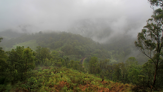
View towards coast from crater saddle |
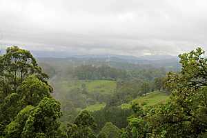
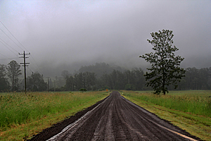
From Murwillumbah I headed inland returning to the turnoff to Nimbin before continuing westward to a low pass at Lillian Rock. The pass allowed an easy gap along winding road across the edge of the crater where the Border Ranges National Park lay. At the top of the pass I stopped at a lookout over Mount Warning and the upper tweed valley. The unsettled weather would only deliver a vista of thick mist that enshrouding the entire volcano. All I could see were layers of misty forest and a small area of farmland below. This was not going to be a day of spectacular views.
The Border Ranges National Park had been proposed from the early 1900s, but it was not established until 1979. Several gravel roads led into the national park area but the heavy rain from yesterday would ensure these steep roads were too treacherous to drive along in a sedan. I will have to save the spectacular views and ancient rainforest for the national parks in Queensland over the next few days, assuming the weather is going to clear. Fingers crossed - you never know at this time of year. Fine weather during the summer rainy season is most difficult to predict.
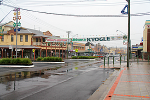
Kyogle |
I continued along the main road down the other side of the crater as the rain continued falling steadily. The hills gradually lessened and the forest gave way to the green pastures of farmland. At some point the hills almost completely diminished and the green grass along the side of the road I had been following suddenly turned brown. Rain was normally a rare luxury here. No doubt the local farmers were celebrating. Here I reached the Lindsay Highway. Turning south I shortly reached the small farming town of Kyogle.
Kyogle marks the westernmost point of the volcano. The town of nearly 3000 people sat at the end of a long ridge of low hills quietly serving the local farming community along the banks of the Richmond River. The river drains the Border Ranges National National Park which I was attempting to explore today. From the park it flows through a broad valley around the southern side of the volcano passing through the large town of Lismore. It collects the tributaries of the southern side of the volcano to eventually reach the coast some distance south of Cape Byron where I had begun this journey.
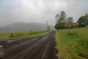
Slippery gravel road |
Steady rain was falling so there was no point in stopping here for long. From Kyogle I travelled northwards along the highway determined to find a way into the park that didn’t involve steep slippery gravel roads. One road did look hopeful until the seal ran out to be replaced with muddy gravel. Following the flat valley towards the mountain hidden in cloud it was very slushy and slippery, so I decided this attempt wasn’t a good idea.
Eventually I reached a junction at the tiny village of Wiangaree. A road to the right was signposted pointing towards Cougall and the Border Loop. I followed the narrow winding road, but at least it was sealed. Some of the place names along the valley didn’t exactly instil confidence though. The first bridge I came to was a flimsy wooden bridge with huge bolts sticking out onto the road and no guard rails. It was the “Grieve Crossing” over the Richmond River. The name itself made me nervous but somehow I safely crossed the rattling bridge without plunging into the dirty river.
Once I was across the river, I reached a village called “The Risk”. Being quite familiar with risk management seeing this hardly lifted my confidence levels.
The Richmond River begins in these hills, so despite the heavy rain over recent days it wasn’t flowing too high. The mountains of the volcano must have absorbed most of the rain and if it had been high yesterday, the floodwaters would already be well downstream on its journey to the coast nearly 400 kilometres away.
Slippery gravel road |
I was now travelling a good 85 kilometres inland from the sea passing through the territory of the Gighabul People, who have for thousands of years been the custodians of the hills and valleys west of the crater rim.
The road followed the main railway line running between Brisbane and Sydney. They say this area was the most challenging section of the entire thousand kilometre railway line, on the final approaches to the McPherson Range. It was called the Lions Road not because of dangerous African carnivores but because it had been funded and built by two lions clubs on either side of the border in the early 1970s. Once the initial road had been built, the government began to contribute to it allowing it to be improved and sealed.
The hilly valley suddenly entered forest and the road began to steeply climb the hill. Thankfully it was still sealed. Shortly afterwards I passed a sign half hidden in the dark forest foliage unobtrusively advising I had entered the Border Ranges National Park. Success!
The road continued steeply winding its way up the side of the mountain through thick mist, but fortunately not for long before reaching the top of the pass on the New South Wales – Queensland border. The main significance of the border was New South Wales had daylight saving at this time of year. This put each state in a different timezone, with Queensland running an hour behind.
Railway loop |
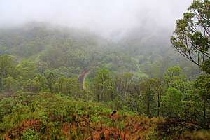
From the top of the 282 metre high pass a steep road dropped to a parking lot. I was still on the Tweed Volcano, but at this pass the landforms of the volcano met the rock of the older Focal Peak Volcano which is centred somewhere to the north-west around Mount Barney. The Focal Peak Volcano erupted 24 million years ago. A million years after it was spent the Tweed Volcano started erupting and gradually expanded to overlap the edge of the volcano around here. At this pass the Tweed Volcano stopped its overlap so from here on this was the Focal Point Volcano. The thick cloud and rain made viewing any of the spectacular remnants of the Focal Peak Volcano impossible.

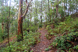
Gum trees along the misty trail |
From the end of the car park there was a clear view down into the misty valley. The cloud had cleared just enough to see a railway line where it came out of a 1600 metre long tunnel going under the pass before going around a hill and looping over itself to descend twenty metres into the Grady’s Creek Valley and continue its trip southwards towards Sydney.
The railway was built following the end of the First World War to open up the rural areas and better prepare Australia for future military conflict. Already the railway extension from Casino to Kyogle to the south had opened up prime farming country.
Rainforest in the mist |
Building the railway across the McPherson Range would be the final and most challenging link between Sydney and Brisbane. Once the route (including the spiral) was surveyed, construction began in 1926. The area’s ruggedness and isolation meant much of the construction was done by horsepower.
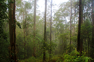
Cloud quickly engulfed the valley below sending sheets of cold rain over the forlorn pass, so I began to explore a track leading from here. The well-graded Border Loop Track gradually descended through gum forest before it darkened into dense rainforest. Rain dripped from the moss covered vines hanging over the track, stretching between the tall trees, some of which were entombed in giant strangler fig trees. The occasional piccabean palm tree indicated this was rainforest similar to that I had encountered on the lower steep slopes of Mount Warning.
Spaghetti of vines |
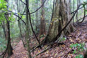
The foggy cloud cleared just as I reached a junction under a particularly large fig tree. The main route continued a level grade whereas the other track descended into the dense forest. I followed the main route through the rainforest guessing it would form a loop to eventually return here.
The track eventually reached a small gully where it turned and began to double back in a loop initially dropping a moderate descent before it began to pass a handful of moss covered fallen logs. The moss was saturated in the rain of recent days, looking very green and healthy with drops of the liquid diamonds dripping off its delicate filmy leaves.
Returning through the gum forest |
The loop ended reaching the big fig tree as I had predicted. From there I followed the track back up to the lookout. Thick mist enveloped the forest again creating a cold eeriness to it.
Once back at the lookout I headed up the steep road back to the saddle.
Heading down the other side of the pass I knew it will be a long road heading through the thick misty rain into the Queensland side of the volcano. Fortunately the weather was forecast to finally clear.
<< Previous | Next >> |
|
||
About this Page
|
||
|
|
|
Where is Walkabout Jeff? |
|
|

|
|
What is happening in Walkabout Jeff's hometown?
|
|
|

|
|
Who is Walkabout Jeff?Any normal person's idea of going out involves going to the local pub for a drink with a few mates. Walkabout Jeff isn't normal.
|
|
|

|
Follow Walkabout Jeff |
|