--- Archive files ---
Home > Travels > Tweed > 7 |
Plateau of the Green Mountains
THE ERUPTIONS that formed the Tweed Volcano lasted for hundreds of thousands of years. Layer upon layer of molten rock was deposited over time. Some of these layers were of soft rhyolite. Others were the much harder black basalt. Over the 23 million years since the eruptions, the heavy rains the mountain has attracted has severely eroded the soft rhyolite into deep gorges and ravines leaving the harder basalt layers to form large plateaus of lost worlds above the otherwise impossible terrain.
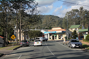
Canungra |
Fortunately the rain had eased off by the time I had travelled about 90 degrees around the volcano from the border loop to Canungra, a small town nestled at the base of the Green Mountains. It was originally named from the Aboriginal word for the small owls that live here. Although the surrounding terrain was already quite mountainous, there were still 35 kilometres to go before I reach O’Reilly’s, my next destination.
Wallaby |
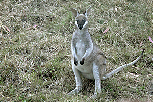
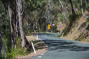
The road quickly narrowed before beginning its long ascent, winding around tight single lane corners hugging the steep sides of the hills. Some of these corners had cattlestops between the paddocks of the farms of the upper valley. This was the dry side of the mountains, so the ground was covered in thick grass growing under the tall gum trees, a forest type known as dry eucalypt.
Wallabies sat in the grass along the verges of the road, resting and awaiting the cool of the evening to set in. It was a slow climb up the mountain. You certainly wouldn’t want to be in a hurry to get to the top. At least though there was a road, climbing to the top of the O’Reilly’s Plateau over nine hundred metres above sea level. Eventually the terrain did ease a little just as the road entered thicker bush known as dry rainforest (a bit of a contradiction in terms).
Road heading up the mountain |
I passed what is now an inconspicuous corner known as the dump. In early days horses only reached here and travellers were effectively dumped to hike the rest of the way up the mountain to O’Reilly’s plateau.
A little further up the road was a turnoff to the top of a cleared hill from where I had wide views around the countryside. By now the rain had long stopped falling and there was even some blue sky poking through.
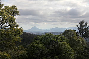
Lookout |
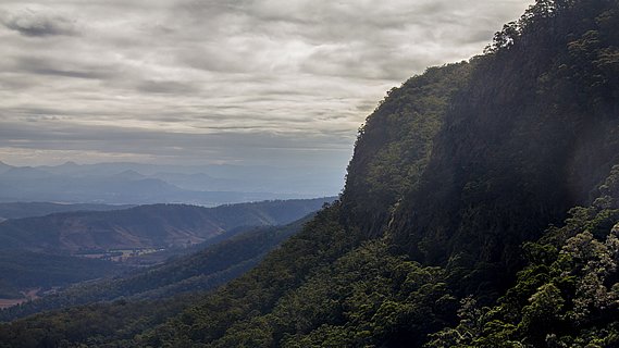
From here there were 270 degree views of the northern slopes of the volcano, gradually descending towards Brisbane and Gold Coast cities unseen in the distance. To the north the Canungra Valley extended back downstream between the Tambourine Mountain plateau and a sharper ridge, both parts of the ancient shield volcano. From here the plateau appeared very flat as it gradually eased downward following the hard basalt lava flows of 23 million years ago.
View back to Mt Lindsey |
To the west the cloud had cleared enough for me to see Mount Lindsey and Mount Barney. These were the highest remnants of the Focal Point volcano, which had erupted around a million years before the Tweed Volcano. The peaks stood sharp and jagged showing much greater levels of erosion than this volcano. Perhaps most of the rock that had created the Focal Point volcano was soft rhyolite.
Just down from the lookout was a large low valley of farmland. The climate here was quite rough given the latitude, but there was a large alpaca farm overlooking the grassy gully.
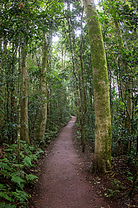
Narrow road through the forest |
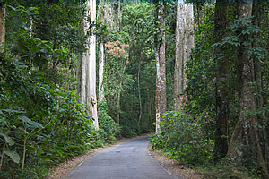
Upon leaving the farm the road suddenly re-entered the dry rainforest significantly darkening the road. The narrow road wound its way between the huge trees continuing uphill along the top of the flat ridge until suddenly arriving at O’Reilly’s.
It was strange seeing a large resort set in such a remote location. With the civilisation came a huge abundance of birds in greater concentrations to that normally found in the rainforest. Bright yellow and black bowerbirds were flying around. One had created a nest near the road. The brightly coloured males attract mates by building the nest and decorating it with anything blue it could find to attract the less coloured females. This nest had all sorts of blue rubbish that had accidentally been dropped or perhaps extracted from the rubbish bins over the recent years.
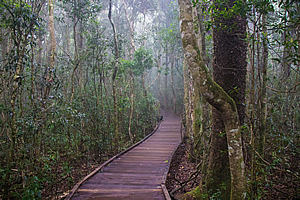
Boardwalk through the misty forest |
Two tracks led from the end of the road. The main track to the left headed on a level grade into the forest. A nature walk followed a boardwalk into the dry rainforest to the right. I joined up with a nature group and followed the boardwalk. The guide who was an older fellow from New Zealand led the way.
Just as we entered the boardwalk thick cloud lingering from the earlier rain enveloped us. The boardwalk negotiated its way around large trees with huge tangled vines growing on them. There was almost no foliage at all below the thick canopy that concealed most of the light diffused by the cloud cover. It was all brown here. Brown soil, brown leaf litter, brown tree trunks, brown vines and brown boardwalk. Even most of the birds that darted around and foraged the soil were brown. The only exception was a brightly coloured male brush turkey with its bright red and yellow bits on its face. After five minutes the boardwalk turned off to a large skywalk apparently built by volunteers in 1986.
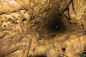
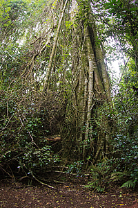
Looking up a hollow strangler fig tree |
At the start of the skywalk a short diversion led to the small entrance of a strangler fig. The guide had earlier showed us a strangler fig that had killed a tree and the host tree had already rotted into sawdust to feed it. This tree was even more advanced with the host tree having completely rotted away. Looking up through the middle of the tree I could see a speck of light at the top where the straight tree had grown through. The sides of the strangler fig were covered in smooth woven shoots which had fused together around the host tree when it was still alive.
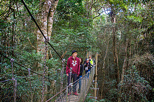
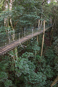
Elevated boardwalk |
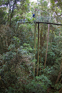
From the tree I followed the main boardwalk which gradually ascended. The ground below dropped off towards the valley causing me to quickly gain altitude. Soon I was a good twenty five metres above the ground in the midst of the green forest canopy. Looking down the ground seemed very bare in comparison. At this level I could see the epiphytes growing in the nearby branches, normally far out of reach and hidden from view.
The sky walk continued to a large tree where a ladder allowed an even higher elevation. With several people up there already I wasn’t going to wait around. I continued crossing the short swing bridges until the ground eventually rose to the same level. I was back on the dark forest floor.
Elevated boardwalk |
Elevated boardwalk |
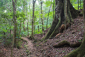
I returned along the main border trail. Interestingly the track here was sealed, following the edge of a heavily forested ravine that dropped a good three hundred metres down into the valley below.
Border track |
Tall strangler fig |
Upon returning to O’Reillys I found another trail heading into a wide sweeping gully. This was the Wishing Tree Track. The trail gradually descended into the valley towards Moran’s Creek. Unlike the other side of the ridge where the drop was enormous, here it was just a low valley with a small stream running through it. Technically the valley runs down the middle of the plateau.
Wishing Tree Track |
Lamington National Park established in 1915 around the O’Reilly farm. There were several other farms up here, but the conditions were so tough in this remote place that all the other farmers sold their land back to the government to create the park. Covering 20,600 hectares, Lamington National Park is the second largest national park on the scenic rim. In 1994 it was declared part of the Gondwana Rainforests of Australia World Heritage Area due to the areas of ancient temperate forest discovered in the higher parts of the plateau.
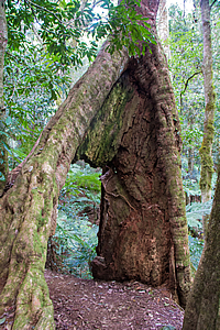
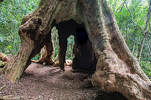
I eventually reached the top of a small steep gully where not much more than a trickle of water flowed through. It seemed they didn’t get as much rain over this side of the mountains although the storms usually dump a lot of rain here. The track started descending into the gully, but passed through the roots of several trees. The roots had holes big enough to easily walk through. From these trees the track crossed the stream over a small swingbridge. There was very little water in the gully, but it was mostly hidden by a thicket of tree ferns below the bridge. Upon reaching the other side the track descended along a narrow ridge held together by several large trees. The ridge reached the bottom of the gully where it met with a larger gully with a lethargic stream meandering its way down the valley. I had reached Moran’s Creek.
Hollow tree |
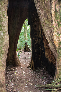
Hollow tree |
The track rose above the gully along a small plateau before reaching a large tree at a junction. A side track headed down into the stream towards an area of glow worms that will be visible at night. It was still the middle of the day so I didn’t see any point in waiting around.
The Wishing Tree |
The main track passed through the tree itself. It was an old strangler fig with a couple of seats set up inside of it. This was the wishing tree. Not that I made a wish here. The roots standing out over the ground were like the fingers of a giant hand.
A camp had been set up here during the great depression when the tracks were being built. Life here was very basic and isolated. A corrugated iron kitchen area and tent accommodation was used for the builders. Each working man had to carry their own tent and fly, an axe, pick, shovel, mattock and crow bar. Despite the tough back breaking conditions, the work was stable in a time of very high unemployment.
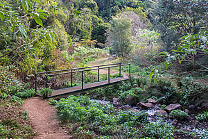
Bridge over Moran's Creek |
From the wishing tree the track descended to follow the side of the stream. It crossed over on a narrow beam bridge before reaching what looked like an outdoor chapel with rows of seating. The track continued following the side of the stream past moss covered trees followed by scrubby thicket until crossing over a small bridge to a dirt road.
A safari bus was parked on the road. It was empty but I could hear the sounds of people at a nearby flying fox. A huge half dead tree rose from the middle of the clearing with a picnic table underneath it. I followed the dirt road past the tree to where it forded across the stream and continued following its way around the ridge.
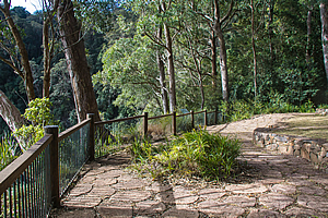
Edge of the lookout |
It was not long before I reached a large lookout. I could hear the nearby stream tumble over a waterfall, but I couldn’t see it. Instead I could see across the valley where a cliff dropped vertically a hundred metres into the forest below. The walls of the cliff continued around to a ridge where I was heading. From there the volcano ended and the terrain was low.
For the first time I could now see Mount Lindsay, as part of the Focal Point Volcano where I had travelled to earlier. The rain had concealed all view but fortunately it was clearing, with sunny weather on the way.
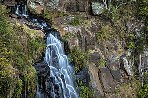
Moran's Falls |
I continued following the track which headed back into the dark gully where a small concrete bridge crossed the stream. The creek cascaded down the gully for about a hundred metres before plunging over the edge. From there the track headed gradually uphill through the dry rainforest for about two hundred metres to a lookout over the edge of the cliff.
From there I had a clear view of the waterfall plunging from the forested rolling hills of the Lamington Plateau down the cliff into the forested valley below. The cliffs were solid rock with grass growing in the occasional cleft. To the right of the waterfall the forest became more barren as it continued to Castle Crag (Millerrijumm Birin). The terrain above the waterfall was fairly level on the thick layer of solid basalt. The cliffs were made from the much softer rhyolite.
Track to Python Lookout |
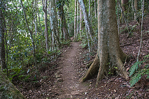
From the lookout the track ascended the hill gradually meandering its way through the dry rainforest. Unlike the wetter rainforest of Moran’s Creek the leaves of the trees were small and leathery to help preserve the lower quantities of moisture in this area. The roots of fig trees wrapped themselves around their host trees and a thick tangle of jungle vines broke up the otherwise vertical lines of the tree trunks towering towards the sunny canopy. It was somewhere around here that the plateau was first settled. The forest has long overgrown and taken over the hut over the cleared farmland again, but it was obvious this area had once been cleared as farmland as the trees in this area had very thin trunks.
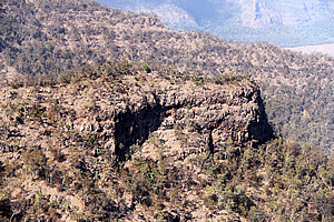
Castle Crag |
After half an hour the track reached the road. From here another track headed back into the forest northward towards Python Rock. I followed this track as the clouds continued to clear to illuminate the forest in strong dappled sunlight. I reached a small clearing where some famous ground dwelling bird had lived for a long time.
The track suddenly turned and the forest began to thin. After a couple of downhill switchbacks I reached a danger sign giving a warning about not straying from the track. The forest suddenly changed to grass trees standing about a metre and a half high. They would have been about a hundred and fifty years old. The track followed the top edge of a rock to the top of the cliff. From here I had a spectacular view across the Lamington Plateau and over Castle Crag.
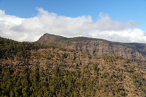
Looking towards Lost World Plateau |
Moran’s Falls was visible now in the distance plunging from a low hanging valley. It was not as big as the streams either side. Looking further past the plateau was the deep valley of the headwaters of the Albert River. Above where Moran’s Creek met the Albert River was a long knife edge ridge that was largely barren. It was very exposed.
Across the Albert River stood the Lost World, a plateau rising above the valley floor with precipitous cliffs all around it. The top of the plateau sloped upwards towards the centre of the volcano, as did most of the other landforms. A hard shield layer of basalt had erupted at some stage with softer layers of rhyolite in between. The basalt resisted erosion whilst the rhyolite has been weathered into near vertical cliffs between the basalt layers.
I returned along the track back to the road, which gradually ascended the gently sloping plateau towards O’Reilly’s. The forest here had been largely untouched with giant trees growing right next to the winding narrow road as a clear reminder that until a few decades ago this was just another walking track.
<< Previous | Next >> |
|
||
About this Page
|
||
|
|
|
Where is Walkabout Jeff? |
|
|

|
|
What is happening in Walkabout Jeff's hometown?
|
|
|

|
|
Who is Walkabout Jeff?Any normal person's idea of going out involves going to the local pub for a drink with a few mates. Walkabout Jeff isn't normal.
|
|
|

|
Follow Walkabout Jeff |
|