--- Archive files ---
Home > Travels > Tweed > 9 |
Gondwana Forest on the Crater Rim
A FOREST more ancient that time itself drapes the mist enshrouded tops of the crater.
First of the Antarctic Beeches |
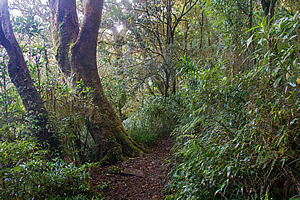
Having hiked up the West Canungra Gorge to the source of the Toolona Creek, the terrain suddenly changed. The deep gorge completely petered out into a large plateau surrounded by what seemed to be very low hills.
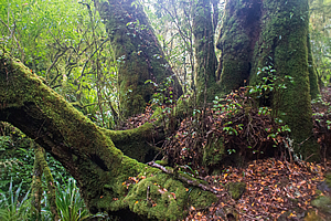
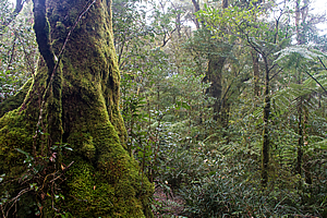
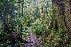
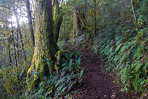
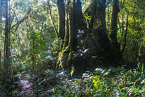
The track was well graded through otherwise an impenetrable forest of gnarled windswept trees with countless moss covered branches having fallen off them in many storms past to create an impossible obstacle course.
Track through misty beech forest |
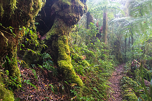
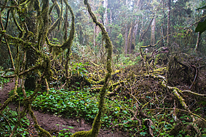
Thick yellow green moss was growing on everything both living and dead, except the dark trunked tree ferns that were growing into a lower canopy just above head height.
The forest was dominated by magnificent wind swept Lophozonia Moorei (previously known as Nothofagus moorei before the Lophozonia was recognised as a separate genus) – the Antarctic Beech tree that came from a time so distant that it didn’t belong here, certainly not to the driest continent on Earth.
Ferns in the forest |
These magnificent trees once formed an enormous forest covering Australia and Antarctica when the two continents were joined together hundreds of millions of years ago. They survived Australia breaking off from Antarctica, then survived all the ice ages that came as a result of the Southern Ocean forming between the two continents cooling off Earth substantially. The great beech forests of Antarctica died out when the entire continent became an ice sheet, but the remnant beech trees survived on the continents that broke off from Gondwanaland.
Antarctic beech forest |
Australia gradually dried out as it pressed its way northward on its collision course with Asia. The vast beech forests that once covered most of the continent gradually cowered away into a few isolated regions. The heat resistant species survived in the lower altitude tropical rainforests, but the temperate beech trees found several refuges in the highest and wettest places in Australia. Lamington National Park is the northernmost of these temperate rainforests of ancient beech trees.
Antarctic beech forest |
Similar varieties have survived in New Zealand (the silver beech is very closely related), and on parts of southern South America (Nothofagus Antarctica). These are different varieties that had evolved to quickly adapt to the rapidly changing landscapes of these mountain building ravaged countries. The beech trees in Australia on the other hand have remained largely unchanged in over a hundred million years.
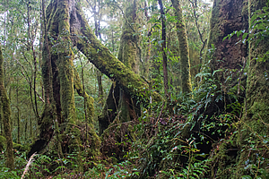
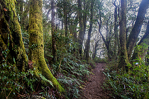
The ancient trees stood erratically defying gravity in the thick mists of the upper plateau. Their ancient gnarly trunks were covered in a thick layer of moss saturated with the thick moisture that perpetually hung around the mountains fed by the prevailing south easterly winds.
Antarctic beech forest |
Life was tough at this altitude. Even during this time of year in the heat of summer warm polar fleece tops are often needed to provide warmth against the cold dampness.
The track continued climbing gradually until suddenly reaching the border track at the edge of a kilometre high ravine. I had reached the edge of the crater.
The track now followed the top of the McPherson Range, or more commonly known as the border range, where New South Wales ends and Queensland begins. The aptly named Border Range Track followed the top of the crater before following a flat range on either side to Binna Burra to the east and O’Reilly’s to the north. Binna Burra is the Aboriginal word for “where the Antarctic beech trees grow”. Although there are some clumps of beech around the Binna Burra area, it was a lot more prevalent here.
View from Woongooga Lookout |
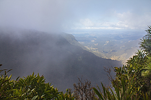
I needed to get back to O’Reilly’s by nightfall, but briefly headed in the other direction to the Woongoonga Lookout, just below the summit of the queen of the mountains from which the Toolona and Canungra Creeks flow to the north.
From the lookout I could see under the bank of swirling cloud across the large crater that now formed the Tweed Valley. Mount Warning stood dominant in the middle of the crater. It seemed surprisingly small from here, perhaps because I was about forty metres above its summit at this lookout.
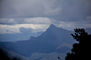
Mount Warning |
Below me the sides of the crater fell very steeply through forest down into the valley far below. No wonder they had created the border along this range. Crossing over the border would be almost impossible apart from crossing one of the few narrow passes cut deep into the mountain.
Cloud continued to climb the side of the crater intermittently blocking the view as I started the trek along the top of the range heading westward along the Border Track. The terrain was rather flat and the well formed trail a little boggy. The crater rim was surprisingly even along the top but there were hills causing the track to rise and fall. When going around a hill it went out over the crater.
Antarctic beech forest |
At one point I reached another viewpoint, the Toolona Lookout. The small lookout had a very similar view to the previous lookout. The cloud had cleared a little and was now hovering just above the summit of Mount Warning.
From the lookout the track continued through the ancient forest. There was not a sound apart from an approaching fit elderly couple from behind doing the way walk from Binna Burra to O’Reilly’s. There were no animals that I could see or hear. Most species here are nocturnal retreating by day to come out only in the darkness of the misty night.
Fallen beech tree |
I reached a small clearing where a giant Antarctic Beech tree had fallen during a recent storm. The storms up here are often very severe. I certainly wouldn’t want to get caught up in one. The entire clearing was littered with the moss covered branches of the fallen tree and already the surrounding vegetation was fiercely competing to create a new canopy. The moss on the branches was no longer feeding on the living tree, but its role had now changed to aid in its decomposition back into the primordial dust of the ancient volcano.
Antarctic beech forest |
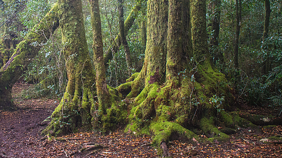
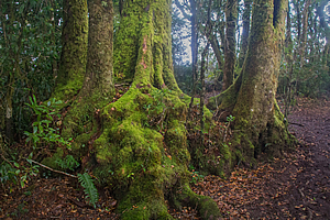
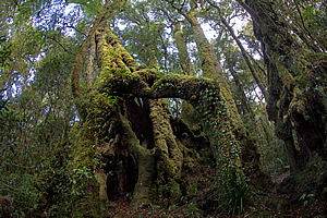
The Antarctic Beech trees were unlike any I had ever seen. The species I have seen throughout New Zealand and on Borneo were single trunk trees, the older specimens having buttress roots to hold themselves up against the strong wind. The beech trees here were very different. The trees usually formed circular clusters and the lower two to four metres of the trunks were extremely knobbly, as if poorly constructed from wax that hadn’t solidified quite enough and partially collapsed under its own weight.
Antarctic beech forest |
At the start of its life, a single tree grows in isolation. Eventually it will send out suckers to create new trees, essentially creating a ring of younger trees around the main one. The original tree eventually dies leaving the other trees growing and continuing the cycle.
As the trees age, the soil around them erodes. Over the centuries the erosion is quite significant with the soil level dropping several metres. The knobbly bases of the trees were the original root systems that have been left above the ground as part of the trunk as the soil has eroded away.
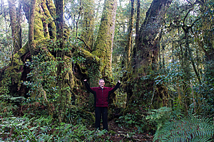
The largest beech tree |
They say some of these trees are thousands of years old. Although the original tree (and maybe even the original cluster) has long died out, the original organism continues to live through the younger suckers that have become trees in their own right. These sorts of trees are amongst the oldest surviving organisms on the planet.
Upon approaching the side of Mount Bithongabel, I reached a particularly large and tall stand of Antarctic Beech. The circle was rather small, but the trees were enormous. The gnarly exposed root systems rose to about four metres above the ground where the soil level had been when they were initially suckered. Now they stood like giant moss covered insects in their perpetual state continuing to grow. The trees were a good twenty, maybe thirty metres high. The roots could easily conceal a hobbit hole with tiny enclosed rooms. No doubt there were a lot of animals sleeping in these hollows awaiting the onset of night.
Antarctic beech forest |
I continued heading around the track below the hill of Bithongabel. The track was beginning to turn away from the line of the crater as a pass at the head of the Albert River was approached.
I reached Bithongabel Campsite, where several tent sites were set up in between the towering Antarctic beech trees. From the campsite the track quickly turned to the north to follow the long Green Mountains plateau back to O’Reillys.
Antarctic beech forest above Albert River |
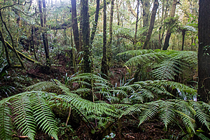
In this section the Antarctic beech trees were at their most magnificent. Clinging to the edge of the chasm dropping into the Albert Valley the trees stood magnificent over the ground cover of ferns.
I reached a junction with a rough track heading towards the top of Bithongabel. I took this track heading through the concentrations of Antarctic beech and thick undergrowth, following a difficult trek taken by the Naturalists Society party over a hundred years past.
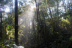
The sun comes out |
By now the cloud was clearing and the sun was shining brilliantly highlighting the wet yellow moss on the Antarctic beech trees. The narrow track continued its gradual ascent until flatting off at the summit of Bithongabel, the highest summit of the Tweed Volcano at 1195 metres above sea level. It was hardly a dominant summit like Mount Warning though, the summits of Toolona and Wallangara peaks were only a couple of metres shorter.
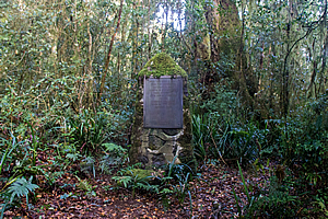
Top of Mount Bithongabel |
A plaque erected in 1966 by two of the original members of the naturalist society who had trekked up here stood solitary at the end of the track. It stated that a group of 11 people celebrated Christmas in December 1918 at a camp they had set up here. They stayed here for several days discovering and collecting new plant species. They noted that although there was a limited diversity in the varieties, the species were unique to this area being high enough above the subtropical lowlands to have a temperate climate with about 2500 millimetres of rainfall each year.
Sun streaming through forest |
The journey here had taken them two days trekking from the dump up to O’Reilly’s to here. With the well-graded track the journey back to O’Reilly’s today will only take a couple of hours.
It was already late afternoon with the sun almost directly ahead of me brightly highlighting the moss on either side of the mysterious trees. It was not long before I was back on the main border track following the gradual descent out of the Antarctic beech remnant of Gondwanaland and back into the subtropical rainforests of O’Reilly’s plateau.
<< Previous | Next >> |
|
||
About this Page
|
||
|
|
|
Where is Walkabout Jeff? |
|
|

|
|
What is happening in Walkabout Jeff's hometown?
|
|
|

|
|
Who is Walkabout Jeff?Any normal person's idea of going out involves going to the local pub for a drink with a few mates. Walkabout Jeff isn't normal.
|
|
|

|
Follow Walkabout Jeff |
|