--- Archive files ---
Home > Treks > Kilimanjaro > Day 5 > 5.2 |
The Martian Desert
FROM Zebra rocks we slowly proceeded to the pass. At sea level this would have been a very easy brisk walk doable in a wheelchair. At around four thousand two hundred metres above sea level, we were struggling up the hill at a very slow pace.
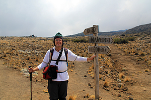
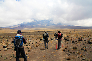
At the Mawenzi Peak junction |
Finally we did reach the pass, which I guessed to be about the same altitude as the highest point on the Inca Trail, the highest I have ever hiked. Here we stopped and had a rest each sitting on a boulder surrounded by the everlasting alpine yellow daisy. There were a few small cairns beside the trail.
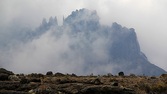
There was still a lot of cloud hovering around Mawenzi peak, but nearly all of the side facing us was still clearly visible. The jagged tops made the mountain look very ominous with needle sharp vertical spires giving it a very gothic look in the swirling cloud. We had a few photos before continuing on. The track briefly descended before rising again on a very gentle slope.
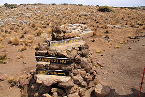
We reached two piles of rocks, one on either side of the track. Both piles had a sign rising above it. The pile of rocks to the left had a small sign pointing down a track to the right – Mawenzi Hut 1.525km, and another small sign pointing in our direction – Kibo Hut 6.199km.
Our group had only walked four kilometres in two hours. We were still only a third of the way to Kibo Hut. The main pile of rocks to the right had an old post with simple pointers to Kibo, Horombo and Mawenzi without any distances.
At the Mawenzi Peak junction |
We continued uphill for another fifteen minutes before reaching the highest point of this section of track. From here we could see across a very large saddle that dropped about fifty metres before gradually rising again to the main summit area of Kibo Peak now encased in cloud. This was where we were heading. The cloud was a bit too low to see the next hut though, but Jaseri told us that it was about four hours away.
I had recalled Desmond telling us about this part of the track. The hut looks deceptively close from here, but it would seem to get further and further away as you approached it.
At the pass was a small metal plaque loosely placed up against a small cairn of rocks reading:
In Memory
Loretta Mae (Colleps) Hedrick
January 29, 1931 – April 29, 1979
From the flame tree of Thicka to the Serengeti Plains. From the Mountains of the Moon to the snows of Kilimanjaro. Africa was her land.
Family and friends.
She had been buried up here. It must have been one hell of a funeral to be conducted up here. I’m not sure whether she had died up here or not (most likely not), but it brought home the fact that we were now in a very inhospitable place, in a place where humans are not meant to venture.
Resting at the top of the saddle |
We followed the track very gradually heading downhill towards the top of the long saddle. Then the track rose a little higher to where we briefly stopped at the top. The wind was blowing now. Fortunately it wasn’t very strong, but it was very cold. The cloud had by now completely covered the sky, and if it were to rain, I guessed we would be experiencing snow.
The wind reminded me of the time when I first heard about Mount Kilimanjaro. It was back in primary school in 1980 when my teacher that year was explaining jet streams, and how she used the mountain to explain that this was one place high enough to experience winds of hundreds of kilometres per hour. I don’t think she had been correct in that as jet streams only occur in temperate and subtropical areas. Here we were just five degrees south of the equator (though it definitely didn’t feel like it now) and well away from the range of the jet streams. Thankfully the chill wind was only moderate.
Lunch at the start of the desert |
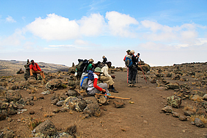
We reached a sheltered crag under which we stopped for lunch. There were a few small shrubs occupying the most sheltered nooks. The three guides went out onto an exposed rock about thirty metres away. There were several small robins around here and they were very friendly. Their coats were very feathery to keep out the cold, but I wondered how they could possibly survive in such inhospitable conditions here at about four thousand three hundred metres above sea level, half the altitude of Mount Everest and now three quarters the height of the Kilimanjaro summit.
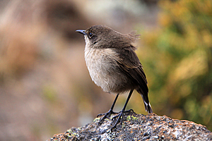
Small bird looking for breadcrumbs |
The birds had obviously established themselves here because one or two groups from the Marangu Hotel would stop here each day to have lunch, and people eating lunch would no doubt drop crumbs. But these birds were so friendly and trusting that we were breaking pieces off our sandwiches and feeding them out of our hands.
Nearby were a couple of very large crows. Perhaps there were some rats around here that would eat whatever the small birds left behind, creating an opportune meal for them. The crows had very large truncated beaks making them an ominous predator. They seemed to be much larger than the Australian crows.
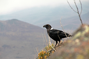
Raven |
From here the ominous Mawenzi Peak had vertical rock faces and needles making it look impossible to climb. No wonder Jaseri had said that three percent of people who go up there never come back. Mawenzi was first attempted by Meyer and Pruscheller after the first ever successful climb of Uhuru (the main summit of Kilimanjaro) in October 1889. They could only reach the top of one of the subsidiary peaks though. The main summit some fifty three metres higher was too difficult. The summit was not successfully reached until July 1912 by German climbers Edward Oehler and Fritz Klute before making the third successful attempt of Kibo.
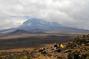
The guides have lunch nearby with Kibo Peak looming in the background |
Across the saddle the cloud started lifting, and we could just see the Kibo hut. It looked a long way away to me, but I could see how people could have been deceived thinking that it was pretty close. The sheer distance across the saddle coupled with the polé polé walk at such a high altitude made it a good four hours away. A couple of small craters were near the other side of the saddle, and the hut marked the lower reaches of the final ascent up Kibo, still covered with swirling cloud.
We set off through the freezing cold wind following the track down towards the saddle. There were only a few tufts of scrub now, mostly low clumps of tussock and the occasional alpine flowering plant. Cloud alternately cleared and covered the area over Kibo. Large patches of blue sky opened up ahead, but not enough to bring the sun to shine on the saddle.
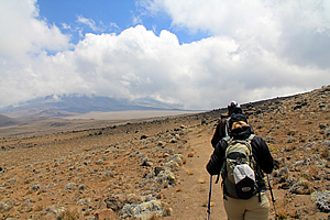
Starting across the desert |
Being at around four thousand four hundred metres above sea level – now the highest I had ever been, we were hiking along very slowly.
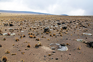
As we approached the lowest point of the saddle, the field of closely spaced boulders changed into a field of rough scoria regolith with the boulders more scattered. The plants thinned. There were large rings of lichen from where a small plant had established itself and continued growing out on itself leaving the old inner part to die. Some of these rings were up to a metre wide and would have been many centuries old.
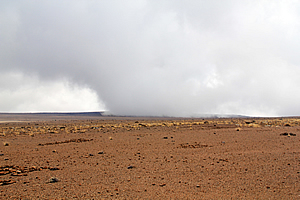
The wind tries to clear the clouds from the mountain |
There were a few small sections along the trail where travellers past had lined up rocks to spell out words – mainly the names of their countries such as Malta. These natural looking words were effective, but somehow broke from the loneliness of the whole place.
In some areas the gravel gave way to sand, where there were patterns from where the soil had become wet, then compacted as it had dried forming roughly hexagonal cracks on the surface.
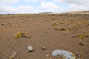
Sparse vegetation on the Martian surface |
We were now past the acclimatisation area and had not seen any other groups since leaving Horombo. Cloud had enveloped the area around Kibo Hut again. The vegetation here was almost non-existent now, giving the feel that we were in a very lonely place.
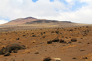
People we had met at the huts and at the Marangu Hotel had told us this area as being moonlike, with the barren lunar surface devoid of life. I thought the scoria here was more like the Martian regolith though, coloured very closely to the reddish butterscotch colour of the Martian surface.
Desert plateau |
I have always wanted to go to Mars, but that would be impossible. No one has been to Mars yet, and no one probably will in my lifetime. No one has been further away from Earth than the Moon, which is only a tiny fraction of the distance to Mars. We are only just starting to get into the age of space tourism, where you go up to a hundred kilometres above Earth’s surface for a mere few minutes. That is only barely scratching the surface in terms of Martian tourism.
I don’t believe tourism to Mars will happen until we find a way to propel ourselves quickly through outer space. With today’s technology it takes at least six months to get to Mars, and six months to get back. Once you get there you have to stay there for about a year and a half before Earth once more gets close enough to travel back.
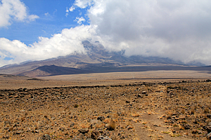
Crossing the long plateau |
Those timeframes are far too much. It is not until we find a practical quantum solution where we can bend the space-time continuum enough to facilitate a short passage without causing damage to the travellers. That is the big challenge. We seem to easily get our heads around the current four dimensional space-time world in which we live, but there are another twenty two dimensions of space-time that we simply don’t understand, yet alone know how to utilise, because as Stephen Hawking puts it, those dimensions are too curled to be of use. We just need to find a way of unfurling some of those dimensions to create a bridge across space. Until then, we’re stuck on Earth.
Cloud rising onto the plateau |
With that in mind, I realised this was as close to a Martian experience as I was ever going to get. I imagined traversing say some of the Tharsis Montes would be like this, but the air would be a lot thinner there. At the base of those mountains, the air would be similar to that of Earth at about thirty three kilometres above sea level, with less than one percent of that at sea level. The air was very thin up here, but it was still had about sixty percent of the air pressure found at sea level. The tops of the Martian volcanoes tower above the atmosphere, so you are in outer space when you reach the summit.
Looks like Mars |
The air was terribly thin up here, but the clouds were evident that we were far from being in outer space. I then realised that I was up here celebrating my fortieth birthday, and perhaps space tourism will be cheap enough for me to celebrate my fiftieth in outer space. Food for thought.
Aside from the clouds, this really felt like a Martian experience, with absolutely no life here apart from ten people, seven tourists from different parts of the world, and three guides, struggling along.
Finally Jaseri signalled that we needed to stop. We were at the bottom of the saddle now. As we rested, a sole hiker approached us from behind, and passed us, doing quite a good pace. He passed us, and gradually disappeared into the distance towards Kibo.
<< Previous | Next >> |
|
||
About this Page
|
||
|
|
|
Where is Walkabout Jeff? |
|
|

|
|
What is happening in Walkabout Jeff's hometown?
|
|
|

|
|
Who is Walkabout Jeff?Any normal person's idea of going out involves going to the local pub for a drink with a few mates. Walkabout Jeff isn't normal.
|
|
|

|
Follow Walkabout Jeff |
|