--- Archive files ---
Home > Treks > Kinabalu > Day 4 > 4.3 |
The Rocks tried to Break my Spirit
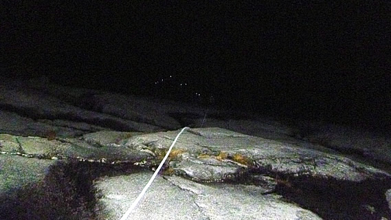
THE TERRAIN changed dramatically following the short stop at Sayat Sayat. We were now climbing on bare rock with only the occasional patch of grass or other vegetation growing between the cracks. The white rope showed us the way up the steep rock. Looking above me I could see a very long row of lights. The headache and nausea that I had felt further down the mountain had completely gone by now.
We continued ascending across the steep rocky face. Although the white rope was trailing along the ground beside us, it was not steep enough to necessitate holding onto it as had been the case earlier. Its function now was to guide us towards the summit still a long way ahead in the blackness of the night. The trees that had kept us company throughout the trek so far had disappeared and the only vegetation was grasses growing in the cracks in the rocks.
The granite felt quite slippery from yesterday’s rain. Sapinggi who was now walking next to me told me not to step on the dark patches. Those were the wet areas where the water was seeping down the rock from yesterday’s rain. The lighter patches were dry providing a firmer and safer footing. It was getting very cold now, but not windy yet. The stars were still bright overhead, and I could see a line of head lights rising steeply ahead of me into the sky. The gradient of the mountain seemed to decrease as we gained altitude.
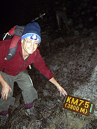
At 3800m ASL |
I recalled Richard telling us that we would pass two peaks before reaching the summit on top of the third peak. I had not seen any peaks yet, so knew there was a long way to go. Curiously I had not seen Richard since leaving Laban Rata, so I assumed he was at the back of the group.
Finally I saw the 7.5 kilometre marker at 3800 metres above sea level. I stopped there to get my photo taken. I couldn’t see any of the rest of the group up here, but there were two guys from another group, and I took their photo and they took mine. For me this was another significant milestone, having ascended to an altitude higher than New Zealand’s highest mountain, and higher than Mount Fuji in Japan where both my brother and sister have climbed. I was apparently now higher than any of my family had been. At this altitude the air was starting to get rather thin, and my headache was beginning to come back, but only very mildly this time.
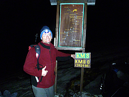
At 3929m ASL |
The ground remained flat and the steepness seemed to reduce as I continued ascending the mountain, passing the eight kilometre post at 3929 metres – just a hundred and twenty nine metres gain in altitude since the last post five hundred metres ago. At this point I still couldn’t see anyone else from my group. Had they gone on ahead or fallen behind? I suspected the latter. I had now caught up with the next group and passing the slower members. I didn’t know if any of the people immediately behind me were in my group. I wasn’t too worried though as our assistant guide, Lianty, was walking about three metres ahead of me. If I had separated too much from the rest of our group he would have helped me back to them. So long as one of the guides was near me, then there was nothing to worry about.
The rope I was following was now no more than a guide leading the way up the now gentle slope. I looked further ahead along the rope and saw the stream of lights going straight up to what appeared to be a saddle just a few hundred metres ahead. At the saddle the lights seemed to head across to the left only to disappear in amongst what seemed to be huge boulders. It was hard to tell in the almost total darkness though. I had not seen either of the two peaks that Richard said I would pass before reaching the summit. How much further was there to go?
The flat granite terrain suddenly gave way to huge boulders near the top of the broad saddle. There were a couple of people resting under the bottom boulders sheltering from the frigid wind that was now blowing across the saddle, but there was no way that I was going to stop. It was freezing up here and the wind chill was bitterly cold, not much above freezing now. Although this may not seem very cold, it felt extremely cold to me having just spent several days in the steamy humidity down at sea level now some four vertical kilometres below me where it would be about twenty seven degrees warmer given the six degrees per thousand metres rule. I pulled myself together and started scrambling up the boulders behind the people ahead of me. To my left I could just make out the black silhouette of a fairly large peak. It was either very large, or very close. Either way I couldn’t tell in this very poor light. I assumed this would be the first peak, so there was one more to pass before reaching the summit.
I continued scrambling up the rocks, quickly losing my enthusiasm. The courage that had until now driven me towards the goal was starting to wane. It was quite steep and uneven climbing over the huge boulders. I had suddenly lost track of the people in front of me who had managed to scramble up a particularly steep section of rock. Unfortunately I had been remiss in not noting the direction they had taken. Now I found myself not knowing where to go and briefly thought that perhaps this was beyond my capability. Will I have to turn back and head back down to the safety of the lush warm jungle. Had I reached my utter limit?
Then someone on the rock above me in the blackness told saying to go right. I was a little disoriented from the altitude by now but I realised he was talking to me, so I followed his direction and turned right. Initially I didn’t even recall who he was, but a little later I realised he was Lianty, the assistant guide who had been quietly walking up the mountain with me – whether we were at the front of the group or at the back, I didn’t know. I hadn’t seen anyone else in our group for about half an hour now and guessed everyone else would have gone on ahead. That being the case I would have to pick up some speed to catch up to them.
Within two minutes I was above the little cliff that had nearly terminated my quest for the summit. I had received no physical injury at all, but the short section of rock had nearly broken me mentally.
I looked further along the rocky slope I was climbing. There were lights ahead of me, but there seemed to be no end in sight. There was no sign of a second peak, and certainly no sign of the summit. I could see the steep slope rising a bit higher, then disappear most likely into a dip which would no doubt lead to more rises to the summit. Now I was experiencing the terrible illusion where the more steps I took, the further I was away from the summit – what I call the retreating summit illusion. Now this was by no means the first time I had experienced this.
I had first encountered the retreating summit illusion as a teenager back in 1988 whilst climbing a small mountain close to the commune where I lived at the time. The hill was aptly named Sugarloaf and it was very steep. I had climbed the back of it with two others, and upon seeing the summit I had decided to go up whilst they rested with showing no interest in summiting the hill. Sadly I reached what I thought was the summit, and found it was no more than the end of a particularly steep section and there was more distance to go. That happened a second time but third time I was lucky and reached the summit. I suspected the same thing was happening here. I was locked in the fear of climbing something unfamiliar and not knowing how much further there was to go.
I had not seen any markers since the 3929 metre mark, and figured there must be at least one more before the summit. Looking up I couldn’t see much apart from a few lights slowly negotiating their way up the precarious pile of boulders in this remote spot now some four kilometres in the sky in the bitterly cold wind.
I felt ready to give up, but having come this far, failure was not an option.
<< Previous | Next >> |
|
||
About this Page
|
||
|
|
|
Where is Walkabout Jeff? |
|
|

|
|
What is happening in Walkabout Jeff's hometown?
|
|
|

|
|
Who is Walkabout Jeff?Any normal person's idea of going out involves going to the local pub for a drink with a few mates. Walkabout Jeff isn't normal.
|
|
|

|
Follow Walkabout Jeff |
|