--- Archive files ---
Home > Treks > Stewart > Day 2 > 2.3 |
The Remote Southern Side
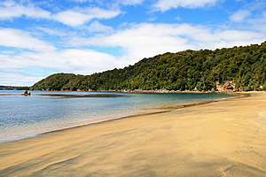
Sydney Cove on Ulva Island was not at all like Sydney Cove in Sydney – not even the way it would have been before settlement.
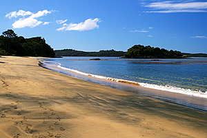
Sydney Cove |
Sydney Cove here had steep headlands plunging into the water. The beach faced eastwards towards the open sea, but was fortunately sheltered by a number of offshore islands at the entrance of Patterson Inlet.
The granite beach swept across to the other side of the bay. There was a lot of sand and small breaking waves indicating this was often an exposed beach. There were a couple of small islands offshore, including one tall and lofty bush covered one just off the end where a small stream was coming out. The others were just rocky reefs that sea birds would sit on.
Forest behind Sydney Cove |
We sat on a log and ate lunch. There were five of us in the smaller group which was better than the larger earlier group. There were two young ladies from Melbourne who had a very strong interest in finding birds. Then there was a recently retired couple from the UK. He had a very booming voice.
After lunch we walked along to the far end of the beach. Furhana led us up a steep bank at the far end mentioning few people know of this track. Only a chosen few get to go on it. We were the lucky ones.
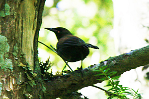
Saddleback |
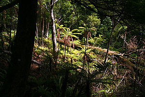
The track was a lot more rugged than the other one we had travelled on this morning. The forest at this end of the island was low and very scrubby indicative of much greater exposure to the prevailing Antarctic weather blowing into the entrance of Patterson Inlet. The track steeply ascended towards the top of the ridge and roughly followed it eastwards.
From the trail we could see a few saddlebacks, riflemen and other very rare birds. It seems though they like to examine us from the direction where the sun was shining, and now it was attempting to come out above us. That means any photography would only show silhouettes of the birds.
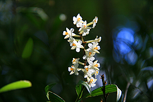
Orchid |
At some point along the trail we discovered a patch of soil where a pig had recently been digging for roots to eat. Apparently pigs had been introduced here at some stage in the past and they had been eradicated, but there still seemed to be one elusive pig at large on the island. Furhana recorded this to report back to the conservation department upon our return to the Stewart Island mainland.
Further along the track stood a magnificent small white flowering orchid growing out of an old tree stump. The surprisingly delicate flowers were tiny and growing in clusters.
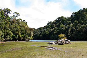
The Snuggery |
The trail continued along the top of the ridge until reaching an old signpost with the right hand track leading to The Snuggery and the left hand track leading to Rogers Bay. We took the trail steeply down to The Snuggery.
The Snuggery is a large mud flat cut deep into Ulva Island. The forest of native beach trees completely surrounds the mud flat coming down to almost touching the waterline at high tide.
We scrambled down the steep track to a small mudflat. Just at the entrance to the track was a magnificent orchid of the same variety we had seen earlier.
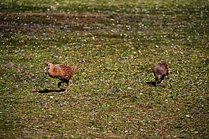
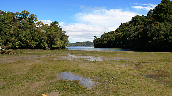
Wekas foraging on The Snuggery |
The tide had mostly gone out leaving a hard muddy surface to walk on. Green sea grass and some sea weeds grew on the surface of the mud. In the middle of the mud flat was a small granite island with a small scrubby tree growing on top. There was a lot more sea grass growing on the other side of the inlet. A pair of wekas were foraging amongst the sea grass.
When the tide comes in the flaccid sea grass would no doubt erect itself into an underwater jungle to support an entire marine ecosystem.
The inlet narrowed towards its entrance at where waterline was. Then it widened out again into two small headlands. The sea had eroded around the edges of the inlet into the granite just below the trees.
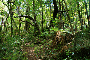
Forest near The Snuggery |
Across the other side of the Patterson Inlet were some scrubby hills. This area was all Maori owned land. There were one or two small huts visible there, but only just. It seemed to be pretty remote and rugged country over there. The land was the peninsula that stood between Patterson Inlet and Port Pegasus further south.
We had our photos taken near the edge of the water. For those of us traveling on the island, this is as remote as we’ll ever get. No other groups come out here and few independent hikers venture here.
Upon leaving The Snuggery, we scrambled up the steep track up to the little junction before continuing back along the ridge through the forest. We found numerous birds hidden in the trees all singing their songs. By now the sun had fully come out and was creating strong shadows in the forest.
Back on Sydney Cove |
Finally I could see Sydney Cove below us, and from there the track steeply descended to the beach.
The beach at Sydney Cove was a little different with the tide further out and the small waves breaking on the beach a little bigger than they had been at lunch time. There were still quite a few clouds in the sky, but they were definitely clearing. The sullen greyness of the overcast skies of this morning had already been forgotten.
A pair of oystercatchers were foraging on the beach. They are loyal to each other for life as I’ve often seen on beaches throughout New Zealand.
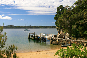
Post Office Cove |
We followed the short track between Sydney Cove and Post Office Cove. At the summit we spotted a pair of native bush pigeons. We called in at the conservation centre where Furhana reported the wild pig diggings before we walked onto the wharf as the boat pulled up. It took us back through the crystal clear water to the mainland of Stewart Island.
From there I returned to my hostel from where I had a great view of the village in the weak afternoon sun.
<< Previous | Next >> |
|
||
About this Page
|
||
|
|
|
Where is Walkabout Jeff? |
|
|

|
|
What is happening in Walkabout Jeff's hometown?
|
|
|

|
|
Who is Walkabout Jeff?Any normal person's idea of going out involves going to the local pub for a drink with a few mates. Walkabout Jeff isn't normal.
|
|
|

|
Follow Walkabout Jeff |
|