--- Archive files ---
Home > Treks > Stewart > Day 4 > 4.2 |
Back to Oban
Following the trail along the burn between Chocolate Swamp and Freshwater River we found some more kiwi feathers and numerous droppings. Some had foraged along the track last night. At this point we stopped for breakfast. We had left Mason Bay Hut in the darkness of night to look for kiwis so we hadn’t eaten since dinner last night. There were some ground ferns nearby so we sat by the bank of the stream and had breakfast.
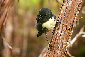
Friendly robin |
During breakfast Dicken explained to us where his name came from. His mother had named him after a character in a fairy tale.
A small robin approached us no doubt attracted by our food. We continued along the trail passing an old wooden bridge which perhaps would have serviced one of the old farms in this area that had been abandoned due to the poor swampy soil and weather conditions.
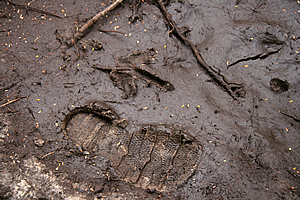
Kiwi footprint next to a size 6 boot |
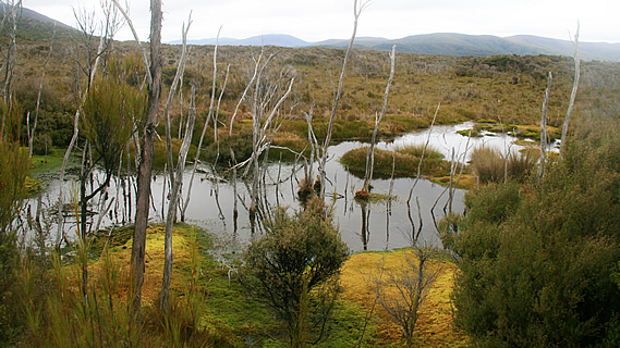
Nearby we spotted a few kiwi footprints in some shallow mud on the trail. Shortly afterwards the kanuka cleared and we walked through scrub over a short rise. It was a very pretty area with a few large swampy pools in the grass surrounded by dead kanuka.
The trail turned to boardwalk and ascended a gentle slope. From here we could see the well named Ruggedy Range over the hills, and in front of us the main range of Stewart Island. Above five hundred metres it was concealed by cloud, but it rose further up to 980 metres above sea level at Mount Anglem, Stewart Island’s highest peak.
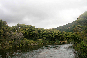
Pond in the swamp near Freshwater Stream |
Upon reaching the top of the rise the trail quickly descended rather muddily to the Freshwater River. It was tidal and had almost no flow with the tide now being in. On the other side of the river across a swingbridge was Freshwater River Hut. There was a sign nearby pointing to the next hut back towards Oban – Fred’s Camp Hut which was five hours away. On this side was a small wharf with a boat moored to it. We climbed into the boat and sped off downstream towards Patterson Inlet.
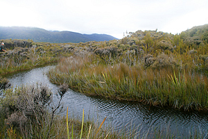
Freshwater River |
The river meandered between the kanuka scrub. The deep water was strongly tannin stained. It was a smooth ride down to the mouth of the river. Once we hit Patterson Inlet though it became extremely rough. The tide was beginning to go out and there was a strong head wind that had created a very rough swell over the shallow water.
The boat jarred violently through the grey waves. The dark hills loomed on either side of us as we passed numerous headlands and islands on our way back to Oban. The windswept trees on the headlands were jagged from exposure.
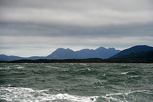
Rough ride on Patterson Inlet |
Eventually the swell started to ease as we returned towards Oban. Finally we turned into the small harbour I had travelled across to Ulva Island in. From there Furhana took us to our accommodations in the four wheel drive she had left here yesterday.
Upon settling back at the hotel I decided to return to the village and do some more exploring. Rain had fallen over the past half an hour but it seemed to be clearing even though it was still completely overcast. I was heading home tomorrow morning, back into the city of Brisbane, so I needed to make the most of it. I walked up the hill from the village and discovered another walking track through the forest. This was a well formed track of fine gravel in between wooden boarding. There were a lot of ferns on this trail, particularly tree ferns. Occasionally the track would change to boardwalk or perhaps a small bridge across a small stream that ran down the bottom of the gully.
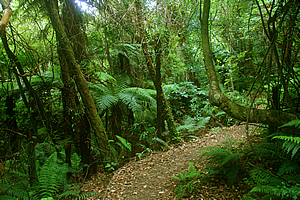
Trail through tranquil forest |
Finally the track came out beside a small beach on Patterson Inlet. My boots were still very muddy from the hike across Chocolate Swamp so I went down to the beach to wash the mud off them. The water was very cold even though it was summer here. Once my boots were clean I walked back up the road towards the town. I didn’t want to follow any more walking tracks as I needed to keep my boots clean for clearing quarantine tomorrow at Brisbane Airport - a world away from this remote island.
Hungry I stopped off at the fish and chips caravan again – the Kai Kart. I was starting to get tired of eating fish and chips but decided to have them anyway as I never have these at home. After all it is a New Zealand tradition. I explored the town with its many very interesting buildings and found a small weather station. I eventually ended up at the beach where I briefly explored before returning to the hostel to rest for the night.
<< Previous | Next >> |
|
||
About this Page
|
||
|
|
|
Where is Walkabout Jeff? |
|
|

|
|
What is happening in Walkabout Jeff's hometown?
|
|
|

|
|
Who is Walkabout Jeff?Any normal person's idea of going out involves going to the local pub for a drink with a few mates. Walkabout Jeff isn't normal.
|
|
|

|
Follow Walkabout Jeff |
|