|
||||||||||||||||||||||||||||||||||||||
|
||||||||||||||||||||||||||||||||||||||
Home > Treks > Sunshine > Day 3 > 3.3 |
||||||||||||||||||||||||||||||||||||||
|
||||||||||||||||||||||||||||||||||||||
|
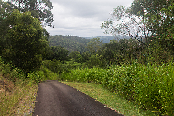
WE LEFT Mapleton Falls following the steep road winding between the trees heading towards Mapleton. From here we had just under six kilometres to go to the Flaxton Walkers’ Camp, our destination tonight and our final campsite on this trip. This was going to take us a good three hours.
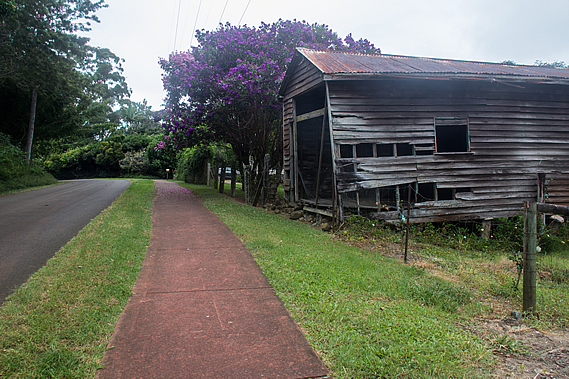
From the park entrance a wide scoria red path led the track beside the road towards the southern end of Mapleton. It was semi-rural out here with long driveways crossing grassy paddocks to their homesteads. There were a couple of heavily weathered wooden sheds looking ready to collapse under their own weight. Mapleton was initially established in the 1880s as a timber milling town, where wood coppers would go into the forest to cut down trees high in demand, namely the red cedar, blackbutt and tallowwood. As the forests gradually became cleared, the exposed land was used by settlers to grow vegetable crops and fruit. By the 1930s Mapleton became a leading citrus growing area.
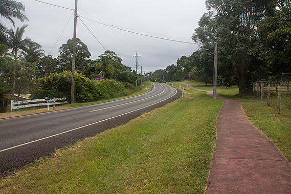
From the early 1900s Mapleton began to attract tourists. The stunning views and cooler climes of the elevated forests attracted visitors. A 2 foot gauge railway was constructed from Nambour, the main town at the bottom of the range, up to Mapleton to carry timber, tourists and other goods into the town. The railway opened in 1915 and continued to run until 1944. Once at the top of the rise, the road ran into the Mapleton – Kenilworth Road, which behind us drops steeply towards the Mary Valley, at one point each lane separating to negotiate its way down the precarious side of the range.
The track followed the road towards Mapleton for a good kilometre or two along the very wide grassy verge before eventually crossing over and going up a steep single lane side road to a few private properties before reaching a gate. We passed through the gate closing it behind us and continued along the gravel road before it became asphalt sealed and steeply dropping through lush grass towards the forest. From here we could see a ridge in the distance. The flat top of the ridge was where we were heading today – Flaxton Walker’s Camp. We had maintained a steady altitude at around four hundred metres above sea level so far today, but to get to the camp we will need to descend deep into the Baxter Gully.
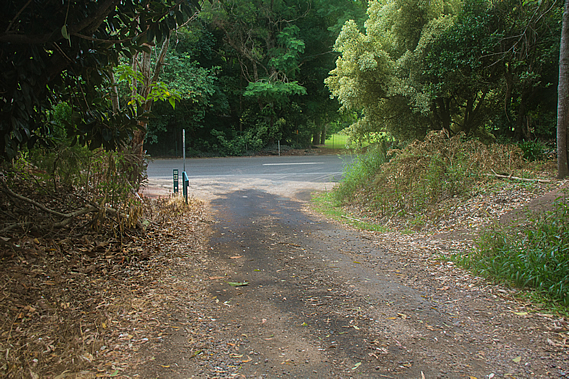
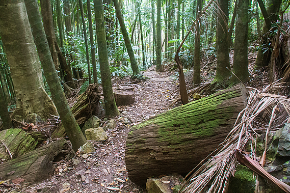
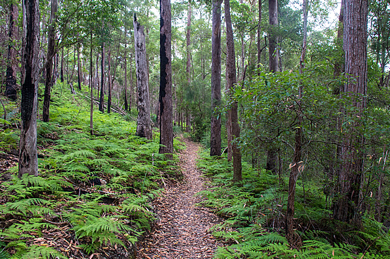
Near the end of the narrow road a sign pointed into a rough track with a sign indicating only experienced hikers should walk through here. The track did look very rough compared to the wide red path we had walked along earlier, but it was still in very good condition so far as walking tracks go. The sign led into the Baxter Bluff Environmental Reserve, a protected plot of land covering the northern side of the creek.
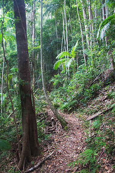
After leaving the road the track descended moderately into dry rainforest. The air was becoming very muggy and light rain was beginning to fall. We descended through thickening forest where several very large birds nest ferns were growing on the ground. As we continued descending the forest undergrowth continued to thicken until we were in full rainforest. By now the terrain was very steep and the track rather narrow winding its way across the face of an old landslide. A hairpin bend narrowly missed a very recent landslide which no doubt came down during the huge storm earlier this year.
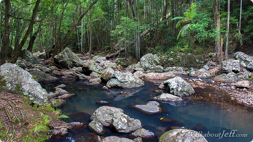
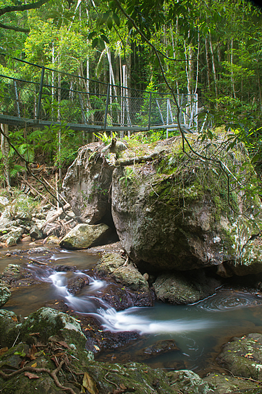
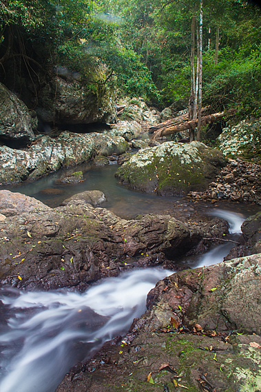
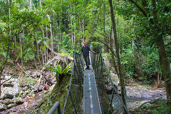
Then I could hear the sound of Baxter Creek flowing unseen down the steep bank. One more switch back and I could see the swing bridge ahead of me. This was the first bridge we had seen throughout the trip so far. We had dropped a good two hundred metres below the ridge. The stream was flowing clear and strong, cascading between large boulders. There must have been a lot more rain over this part of the park the other night, otherwise this would have been running very slow like the Gheerulla Creek.
The swing bridge spanned between two enormous boulders about four metres above the stream. The boulders around the stream were covered in lichen, but otherwise there was no vegetation at all to about two metres above the creek bed indicating last year’s major storms had wiped out the vegetation. Today though, the stream was flowing low, low enough to cross reasonably safely even if there wasn’t a swing bridge. The stream marked the end of the Baxter Bluff Environmental Reserve, and the northernmost boundary of the Kondalilla National Park, the third of the three national parks that the walk goes through. This part of the park isn’t very well known at all. We’ll be walking through it for the rest of today, and much of tomorrow, where we will be passing the more popular parts of the park and reaching the southern end at Baroon Pocket at the end of the trek.
By now the drizzle had stopped falling, so we rested on a large rock almost under the swing bridge. There we discovered our unwelcome passengers. There were several small brown leeches gorging blood on our legs. Despite having bitten through our skin to a good blood vein, we had hardly felt them at all. When they bite they quickly inject an anaesthetic eliminating any pain. Then they inject an anticoagulant to prevent your blood from clotting as you would expect in a minor wound. Once attached they take 15-40 minutes to drink enough blood to fill them, expanding their body size by many times. The blood will feed their eggs allowing them to reproduce.
Once they are full they will drop off. With a bit of effort they could be pulled off, but this could tear at the skin creating an infection. Fortunately one of the guys had some salt with him, so upon sprinkling that on the leeches, they quickly dropped off. Thanks to the anticoagulant, streaks of blood began to run down our legs. Normally the wounds would clot after a few minutes but they won’t stop bleeding for several hours. We crossed the bouncy swing bridge one at a time. A sign said the safe load was either two adults or one adult and two children. On the other side, the main track steeply rose into a gully heading towards the Flaxton Walker’s Camp on the top of the next ridge. A side track headed upstream just above the creek, so we took off our packs and headed upstream.
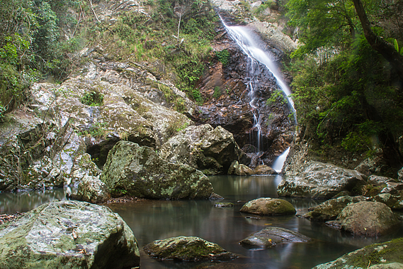
The side track roughly climbed over the boulders in the forest until stopping just short of Baxter Falls. We couldn’t see the falls too well from the end of the track, but hopping out onto the boulders gave us a clear view of the water tumbling down a crevice in the large exposed rock face. Rain started falling again whilst we were resting at the falls, so we decided to press on. As we were heading back along the rough track we could see a couple crossing the swing bridge making their way back to Ubajee. They were running a bit late today no doubt only having left Flaxton about an hour ago. They were the only people with backpacks we had seen all day.
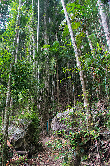
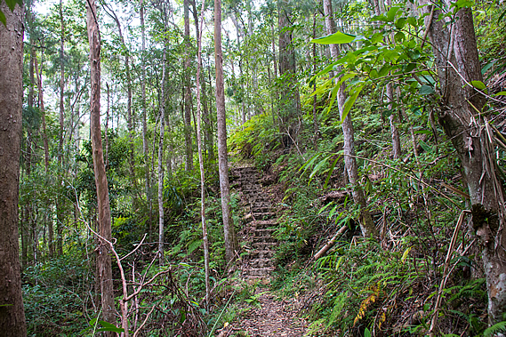
From the Baxter Creek swing bridge we followed the main track climbing steeply through the rainforest up a gully. Almost immediately the rainforest changed to open eucalypt as we left the humidity of the creek and started rising along the sunny side of the ridge. The sky was still completely overcast and light drizzle was still falling. The track turned left out of the gully traversing across a bluffy area with small cliffs above us. The ascent was steep rising on a concrete staircase before continuing along a narrow track rising moderately following above the creek upstream.
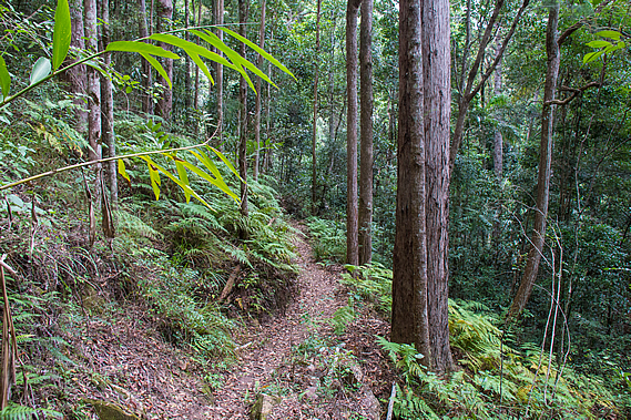
The undergrowth was now thick bracken, but fortunately the track was clear and well maintained. It continued climbing for nearly half an hour before reaching a large hairpin bend redirecting the route to the end of the ridge. As we continued climbing higher we had the occasional partial view across to the other side of the valley. It was all forested apart from one homestead I could see towards the head of the creek near Mapleton.
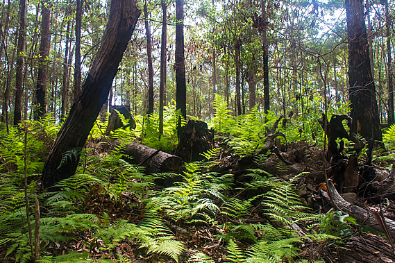
As we approached the end of the ridge, the undergrowth disappeared almost completely and the acrid smell of old smoke filled the air. The trees and ground were burnt from a fairly recent bushfire. The dry eucalypt forests have evolved to not only withstand, but to thrive on fire. As Australia broke off from Antarctica and moved northwards towards the equator, the continent once covered in rainforest dried out and retreated to the relatively mountainous east coast. The forest in the interior of the country gradually adapted into the eucalypt forests we see today. As the country continued to dry up the dry eucalypt forests continued to retreat towards the coast taking over much of the disappearing rainforest, and the centre turned to desert.
A combination of the eucalypt forest’s dry grassy ground cover, dry leaf litter and eucalyptus oils made the forest very susceptible to bushfires. Before humans arrived bushfires were often started by lightning strikes from large non-rain bearing clouds. Although initially destructive, the fires cleaned up the forest and created fertiliser for the trees to continue growing. The thick bark ensured they survived most fires, and even their seeds adapted to the point they would not germinate until burnt in a bushfire to give them the best chance to sprout into a healthy tree.
When the Aboriginal people started settling in these areas the eucalypt forests, they would deliberately burn off large sections of forest to help them regenerate and provide food and other resources for them. Even today areas of forest are deliberately burnt every few years in order to maintain the ground litter and prevent the spread of any naturally generated bushfires. Rainforest species are unable to survive bushfires, hence the huge difference in species between the rainforests and the eucalypt forests. I had noticed the transitions between the different forest types to be very quick.
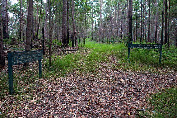
Just before the end of the ridge, the track doubled back continuing to rise moderately. The burnt area quickly ended with plenty of lush bracken growing in amongst the trees. There were quite a few trees that had been fallen and chopped into sections no doubt from the logging days. Eventually we reached a wide firebreak on top of the ridge. There were a couple of signs indicating directions and distances. We had hiked 12.7 kilometres from Ubajee with just 400 metres to go to Flaxton Camp. We had 16.3 kilometres to go to Baroon Pocket tomorrow, our final day of the trip.
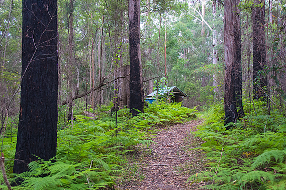
The track followed the firebreak dirt road along the top of the ridge through the tall forest and thick bracken on either side to a junction where a bush split the track into a three way roundabout. We took the right hand side track towards the campsite. Almost immediately we could see the little toilet shed ahead of us. We were the first to arrive at the campsite. Unlike the last two campsites there were no views at all, so there won’t be any sunsets or sunrises tonight. That being said the rain was starting to set in, so we quickly put up our tents in what seemed to be the driest campsites available. The forest contained small trees but there were the stumps of what had once been enormous trees that had been cut down and transported to a nearby timber mill.
Blood was still running down my legs from the two leech bites I had coming down Baxter Bluff. Two solo hikers arrived a little later having hiked from Baroon. They set up their tents in the secluded campsites a little down the gully away from ours.
It was not long afterwards when the rain started falling. We quickly finished our early dinner and retreated to our tents for the night. Although the rain was light, the weather forecast was for areas of heavy rain overnight, so we were careful not to pitch the tents in hollows, or under any dead branches. With the rain drumming down on the tent it was going to be a restless night, but fortunately tomorrow night I’ll be back home in the comfort of my own bed. |
||||||||||||||||||||||||||||||||||||||
|
||||||||||||||||||||||||||||||||||||||