|
||||||||||||||||||||||||||||||||||||||||||||
|
||||||||||||||||||||||||||||||||||||||||||||
Home > Treks > Sunshine > Day 3 > 3.2 |
||||||||||||||||||||||||||||||||||||||||||||
|
||||||||||||||||||||||||||||||||||||||||||||
|
MOST national parks I have explored over the years have occupied tens of thousands of hectares, covering vast wilderness areas taking days to hike through. Some national parks on this side of the Tasman are very small, and Mapleton Falls National Park would have to be the smallest one I have ever encountered.
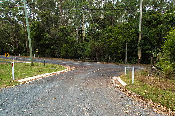
Once across Delicia Road, the track followed a side road heading moderately up towards the top of a low hill. The seal on Daymar Road only lasted a few metres on either side before the road became gravel. There were houses on either side. An old lady was gardening outside one of these cottages, asking us if we had plenty of water, which we did, having collected and treated it from the small water supply at Ubajee earlier this morning. After a couple of houses the area suddenly looked rather rural with mowed grass growing on the side of the road A row of power poles delivered electricity to the shabby rural houses further along the short road.
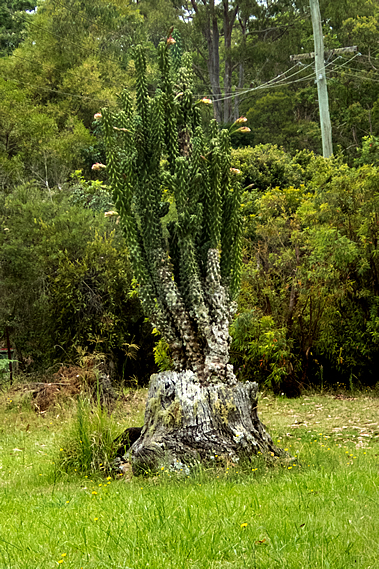
The stump of what had been quite a large tree sat about two metres off the side of the road. A huge cactus towering nearly four metres high grew from the inside of the trunk. It had a lot of large flowers that were just about to bloom. The road ended just past the last property in a dirt track covered in leaf litter entering the eucalypt forest. This was the top of the hill. From here the dirt road descended to a gate marking the start of the Mapleton Falls National Park.
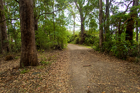
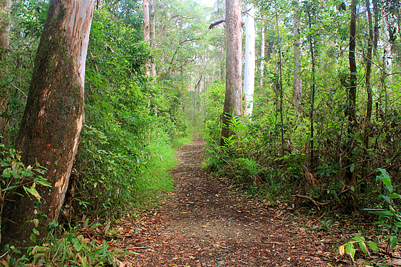
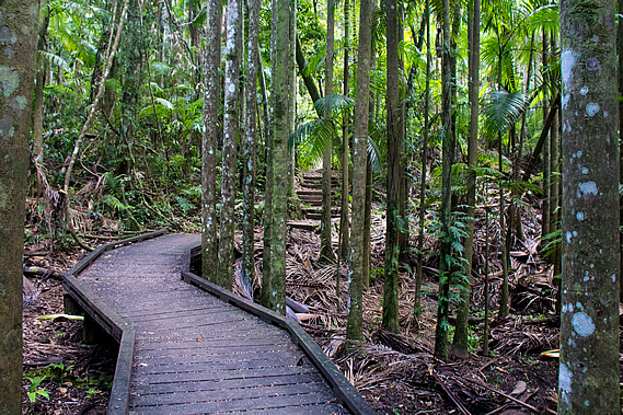
At twenty six hectares, the national park is tiny. It is a rectangular block over terrain too steep and rugged to ever clear. Despite its tiny size, it is a great representation of the vast forests that once covered the top of the Blackall Range. Unlike the other forests we have hiked through so far, this forest remains completely untouched by the timber industry of the nineteenth and twentieth centuries. This tiny pocket of forest remains home to hundreds of plant and animal species. The track didn’t narrow, but continued heading down the top of the ridge through the thickening forest, reaching a junction of the Wompoo Circuit, a short thirteen hundred metre track starting from the Mapleton Falls car park.
The trees through here were spectacular, untouched by the milling that had occurred throughout the rest of the Blackall Range. Some had huge epiphytes of staghorns, elkhorns and birds nest ferns growing in them. As we headed out along the ridge, the thick undergrowth changed to an alternating combination of grass and bracken. The trees became smaller as we approached the end of the ridge, the track gradually turning to double back. Although there was plenty of space between the trees, most of them had large epiphytes of staghorn and elkhorn fern, and of many orchids similar to those I had seen in the Gheerulla Valley the other day. They grow in the trees to catch the stronger sunlight that simply doesn’t reach the forest floor.
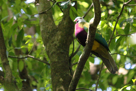
The Wompoo Circuit is named after the wompoo (Ptilinopus magnificus) – a large colourful fruit dove that lives in the rainforests of Australia and Papua New Guinea. I could see one hear them with its distinctive “wollack-wa-hoo” sound resonating through the forest. Then I saw one. Unlike most other doves, the wompoo has beautiful purple plumage around its neck, chest and upper belly. Its lower belly is yellow with green underparts. They grow to around 35-45 centimetres.
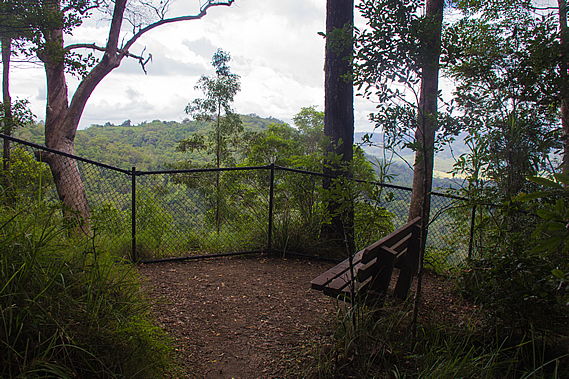
This was just one of the 107 species of bird that live amongst the forests of the Blackall Range. At the end of the ridge was a short gradually descending side track to the Peregrine Lookout, named after the peregrine falcon Falco peregrinus which rests on the cliff faces below the lookout. They are often seen flying around the gorge between August and December. I couldn’t see any today, so perhaps they had already left the area. They are considered vulnerable so it is a locally important species.
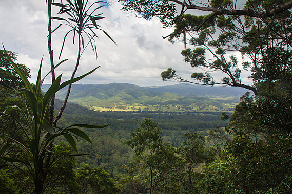
Fortunately the falcons fly above the trees so are easily able to travel from one area of forest to another. Many other species will never leave the forest. Much of the forest has been cleared now forcing some species to be restricted to the small isolated patches of forest with no vegetation corridors to move into adjoining forests if needed. There wasn’t much of a view as it was largely overgrown, but we were at the top of a 120 metre high cliff looking down into the forested Pencil Creek Valley running into the cleared pastoral lands of the Obi Obi Valley before heading up the slopes of the now distant Conondale Range under the still overcast skies.
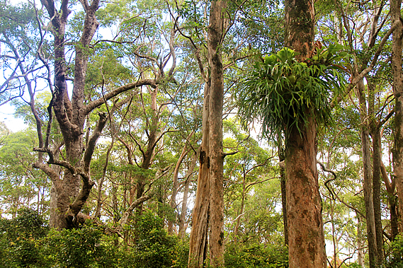
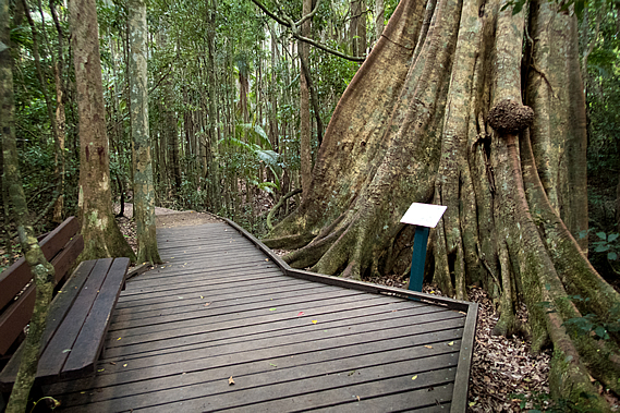
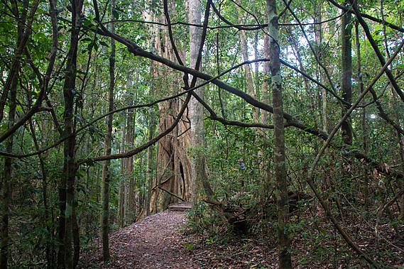
From the lookout the track doubled back below the ridgeline quickly entering rainforest. It descended to the junction of the Wompoo Circuit at a huge fig tree with a seat on a boardwalk beside it. The strangler fig starts life as a seed deposited by bats or birds high up in a tree, usually at a junction of two branches. From there it slowly extends a root down the side of the trunk as its leafy top grows. Eventually the root reaches the ground where its growth is suddenly accelerated sending down more roots gradually covering the tree’s trunk. A large crown of leaves mingles in with the tree’s own foliage, then the fig gradually smothers the host tree until it dies and rots away, providing an enormous boost of nutrients for the fig turning it into an enormous tree in its own right.
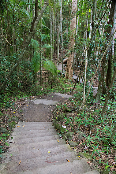
We decided to stop here and explore the short circuit where stairs and boardwalks led through the rainforest passing buttressed trees, and huge tangles of vines. Many rainforest trees have large spreading buttress roots. Scientists haven’t determined exactly why they form the roots, but they may include an aid to help the trees absorb oxygen from the air due to the roots often growing in shallow waterlogged soil. Other reasons include assisting the tree to stand strong during strong winds, and to help retain the leaf litter around the base of the tree to provide nutrients. The reality is probably a combination of the three, where natural selection has determined wide buttress roots gives the tree a significant advantage over other trees that aren’t buttressed.
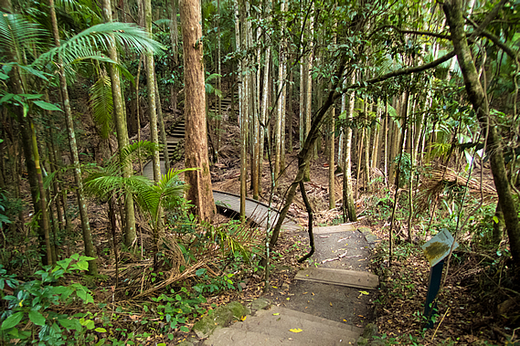
The rainforest was rather dark under the overcast skies. The thick canopy towering overhead, along with the sub-canopy of palm trees caused very little light to reach the damp ground. Temperature and humidity vary a lot less on the forest floor than up in the canopy. The forest regulates the temperature very well. This has forced some plants to adapt to live in these conditions. Some of the trees had lichens growing on them. These are very strange plants, in fact a symbiosis between the much larger fungus and an algae. The lichen absorbs water and nutrients for the algae, and provide it a safe home. The algae in return produces food for the fungus.
After a few minutes we reached the junction we had passed earlier, so returned down the Wompoo Circuit back to the huge fig tree. There were a couple of macadamia trees growing here. Otherwise known as the bopple nut or Macadamia ternifolia, it is commonly assumed to be from Hawaii, where it is very successfully grown commercially. The macadamia is in fact a native to the rainforests of Australia. With the clearing of the rainforests though, it is now at risk of extinction in the wild.
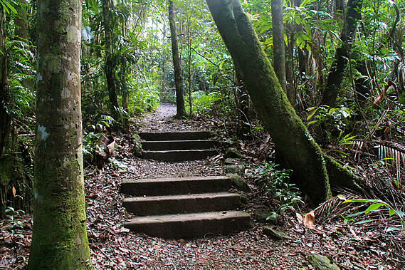
From the circuit the track followed a concrete stairway into a gully. There was no water flowing through the gully but it was filled with piccabean palms indicating the soil here is rather swampy. Their thirsty worm-like roots drink large quantities of water so they only grow in wet gullies. They were beginning to produce the red fruits and will continue to do so until May. This provides food particularly for the topknot pigeons. With much of the rainforest cleared though, these birds are seldom seen these days. When they are seen, they are only in small flocks. Before the rainforests were cleared the pioneers often reported them flying in flocks of several thousand birds.
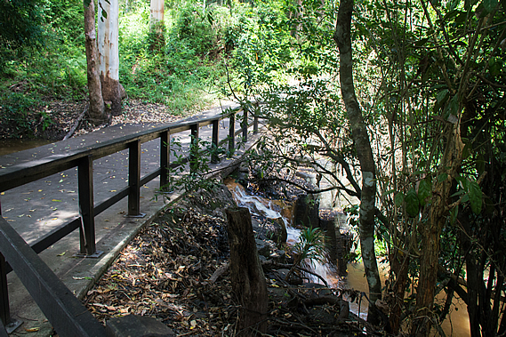
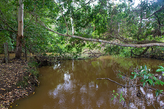
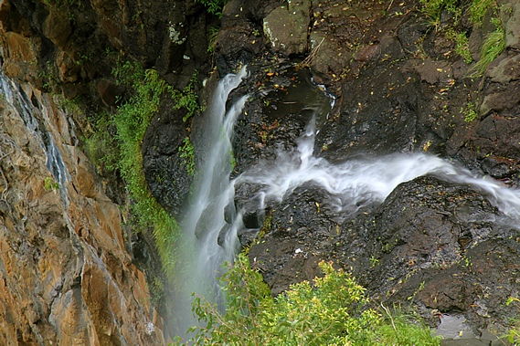
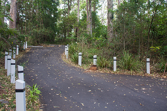
From the gully the track rose on concrete stairs out of the rainforest into a small grassy area. At the end of the grass a ford crossed Pencil Creek. Upstream it was dammed into a still pond. Downstream the water cascaded out of the culvert into a pool at the start of a small rapid leading to the Mapleton Falls. Pencil Creek was named after the native pencil cedars that grow along its banks. Once across the ford the paved track steeply rose to the Mapleton Falls Carpark, the second of the four official starting points of the track. The narrow road edged its way around several tall trees with car parks hidden away in a few nooks.
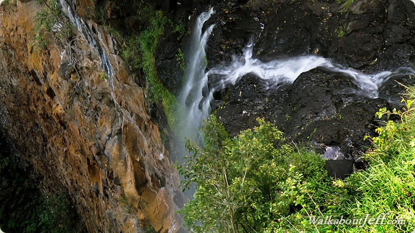
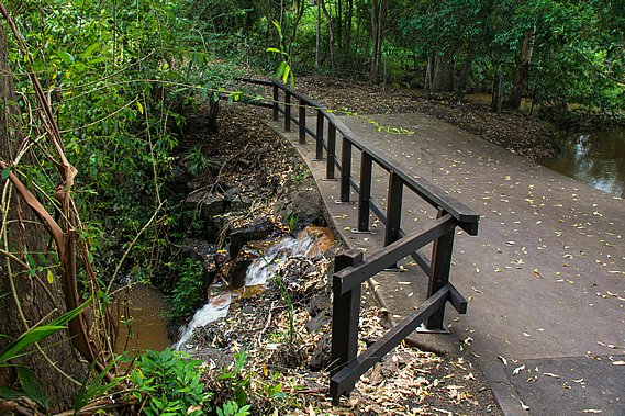
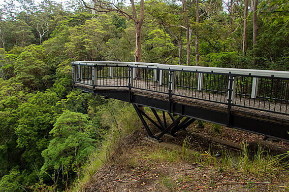
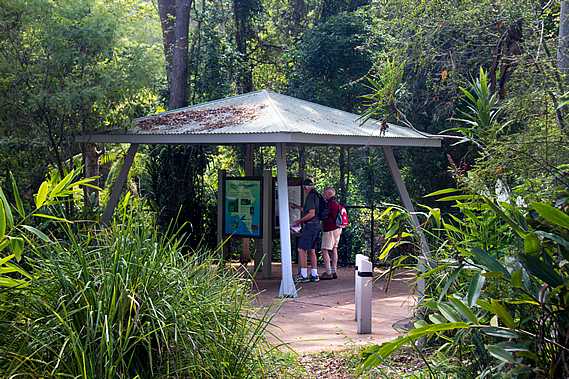
Upon reaching the road there was a small pergola with a few displays about the national park, similar to the one I had seen at the other car park. Just past the pergola was a cantilevered walkway heading out over the edge of the gorge. The cantilevered walkway was closed and had been since the huge storm earlier this year. A small landslide at its base had made it unstable. Fortunately I did go out onto it some time before it closed and managed to get some good shots of the waterfall tumbling off the edge of the cliff below the ford we had crossed a few minutes ago.
Mapleton Falls was originally named Baroon Falls, after the Baroon Pocket of the legendary corroboree where we will be arriving at the end of the hike late tomorrow. The name was changed to Mapleton Falls in 1915 after the nearby town. Baroon Pocket is quite a long way away so the name change did make sense. A flying fox with a viewing cage was erected across the falls in 1919 as it was otherwise difficult to see them from the edge of the cliff. Although quite popular, it was eventually removed due to safety issues. The anchor belts are still installed at the giant brush box tree next to the current lookout.
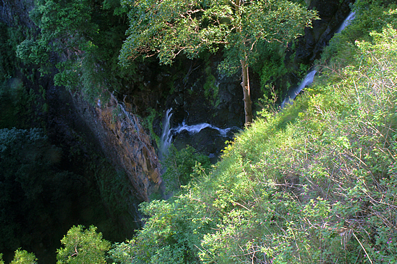
Eventually a cantilevered lookout was constructed, but it was eventually closed in 1995 after becoming unstable following a small landslide. The current lookout was erected shortly afterward. This has remained open until the huge storm in April this year created another small slip rendering it unsafe to access. The land around here must be rather unstable as would be expected at the edge of a high cliff. Today we couldn’t see the waterfall, but I had been out on the platform about a year ago and got some good long exposure shots of the cascading creek dropping down the cliff in a fine spray of mist.
The waterfall mist dropped a hundred and twenty metres into the rainforest gorge below. The vertical cliff had a layer of hard black basalt at the top, and cream coloured softer rhyolite and sandstone underneath. Around 25 million years ago the Eastern Australia volcanic hotspot lay directly beneath this area. The Australian continent has been moving northward for the past 60 million years over the hotspot, so there is a row of volcanoes stretching along much of the eastern coast down to its current location off the west coast of Tasmania.
I have previously completed a superblog on the Tweed Volcano, a massive shield volcano a couple of hundred kilometres to the south inland from the Gold Coast. That volcano formed about 23 million years ago, so two million years earlier, the hotspot was sitting under the Sunshine Coast hinterland. The volcanism was very different up here. Down in the Gold Coast two enormous shield volcanoes were formed, firstly the Focal Peak volcano, then the Tweed Volcano centred at Mount Warning. Up here a large cluster of volcanoes formed. Several lava tubes cut through weak points in the Earth’s crust spilling out basalt that filled in the existing sandstone valleys. The sandstone had been laid here during the Jurassic period around 150 million years ago. The sandstone was subsequently uplifted when a large fault line now located in the middle of the Tasman Sea ruptured around 80 million years ago splitting Zealandia off from Australia as part of the breakup of the Gondwana supercontinent. The volcanoes broke through the sandstone and filled the valleys with basalt lava.
The volcanism to the south of here created the Glasshouse Mountains, where the volcanoes and the sandstone they sat on top of has completely eroded leaving only the mysterious plugs that fed the volcanoes. When each volcano stopped erupting the magma in the chambers cooled very slowly insulated by the surrounding rock. The slow cooling allowed the rock to solidify very hard causing these plugs to remain standing even though the surrounding sandstone has eroded. Here on the Blackall Range, the erupting basalt didn’t form cones. Instead it just filled the valleys with a very hard layer of rock. Over the 25 million years following the volcanism, the softer rock of the ranges eroded down to the level of the basalt, then continued to erode to create the valleys we now see.
This creates a very interesting phenomena. On our first day we had hiked along the bottom of the Gheerulla Valley, which would have once been under the top of a long ridge. The ridge extending back from Gheerulla Bluff would have been one of the valleys filled with basalt, but now standing high above the eroded sandstone valley. This would explain why the top of the Blackall Range is rather flat – certainly flat enough for several towns to be built. The range could very well have been the bottom of a long valley and now stands as a range over four hundred metres above sea level. Some of the erosion though would have been through softer layers of basalt, so it’s now not possible to confirm whether the valleys were once the tops of ridges.
I could see the distinctive hexagonal columns of rock in the black basalt up near the bridge. When liquid basalt solidifies, it shrinks and cracks into long hexagonal columns. Once at the bottom of the waterfall, Pencil Creek continued following the valley through the dense rainforest until meeting the lush green grassy pastures of the Obi Obi Valley. Although from here the valley is wide, further upstream it will narrow into a spectacular gorge creating an ominous barrier to Baroon Pocket. The track will be navigating its way through this gorge.
Although tiny at just 26 hectares, Mapleton Falls National Park had a stunning variety from dense rainforest to eucalyptus forest, all nestled at the edge of a dramatic cliff dropping over a hundred metres into the valley below. |
||||||||||||||||||||||||||||||||||||||||||||
|
||||||||||||||||||||||||||||||||||||||||||||