|
||||||||||||||||||||||||||||||||||||||
|
||||||||||||||||||||||||||||||||||||||
Home > Treks > Sunshine > Day 4 > 4.4 |
||||||||||||||||||||||||||||||||||||||
|
||||||||||||||||||||||||||||||||||||||
|
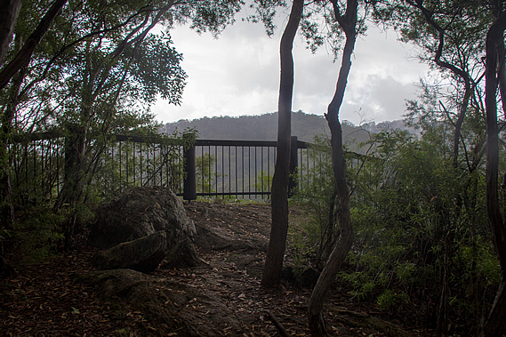
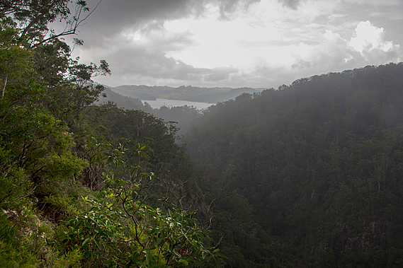
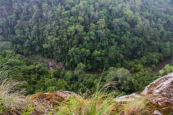
UPON reaching the top of the Obi Obi Gorge bluff a short side track lead to a lookout at the summit. From the lookout a cliff dropped a good hundred metres into the gorge. The stream snaked along the bottom of the gorge in one very long puddle. It was as if the entire gully had been carved out.
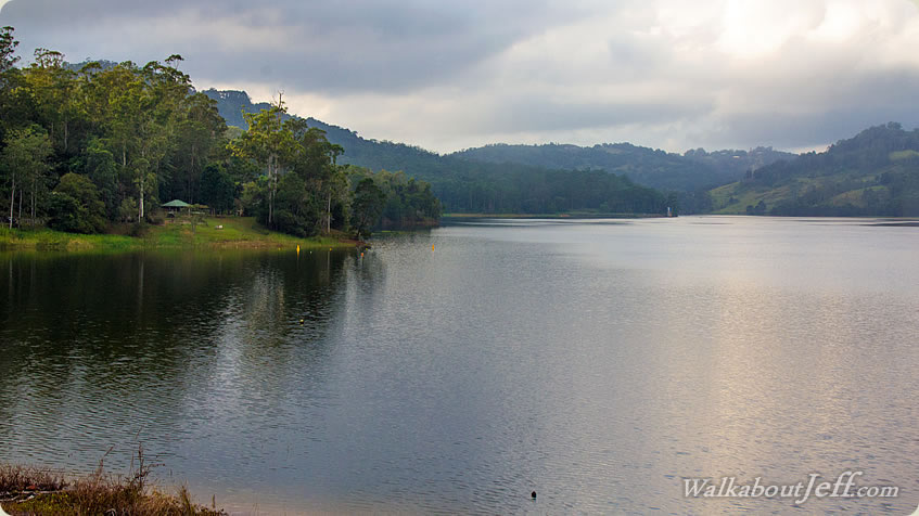
The cloud had grown thick and driving rain was beginning to fall. Thick misty cloud now covered both sides of the gorge, but fortunately there was still a good view along either way. Looking upstream a fine rain mist draped over the forested hills to Lake Baroon, the shores of which mark the end of the track just 2.2 kilometres walk away. Beyond the lake the hills continued towards the small town of Maleny.
The lake occupies what used to be the Baroon Pocket, where the Aboriginal people met for thousands of years for the bunya nut festival. This was recognised by the earliest European settlers to this region and in 1842 New South Wales governor George Gipps ordered this area to be an Aboriginal reserve, not to be touched by the settlers. This became known as the Bunya Proclamation. The reserve covered the entire Blackall Range down to its bottom at Mooloolah on the Sunshine Coast side. It covered everywhere where the Bunya tree grows. Any European settler attempting to live in these areas would be removed, and timber cutting was forbidden in these forests.
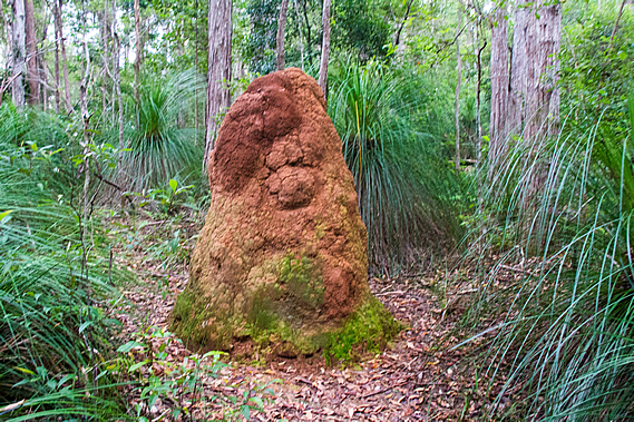
It looked like this area was going to be protected forever, but in 1859 Queensland achieved independence from New South Wales. The following year the Unoccupied Crown Lands occupation Act repealed the Bunya Proclamation providing licenses for squatters and timber cutters. This had been one of the first acts passed by the Queensland government and marked the beginning of the end of thousands of years of tradition for the local tribal people. From the gorge lookout we returned to the track which dropped moderately down the upstream side of the bluff. We passed another enormous two metre high termite mound as we were buffeted by the driving rain soaking the forest.
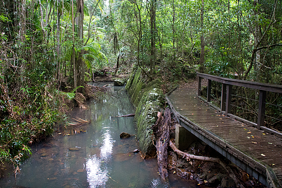
The track descended a spur before turning to the left into a gully where a step bridge crossed a stream. There was no water running through it, but a large grey puddle indicated some water had flowed through here in the heavier overnight rain. The track continued downhill until meeting a small stream flowing over large exposed rocks. We followed the creek downstream flowing in the opposite direction to Obi Obi Creek rather curiously. The track descended into a large patch of palm rainforest. A boardwalk led the way over the swampy forest floor.
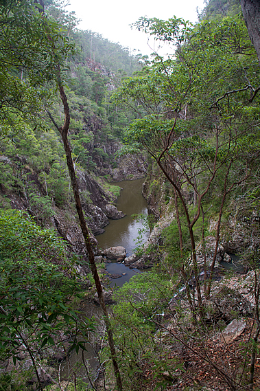
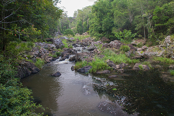
At the end of the short boardwalk the track ascended a little as the creek headed off to the left. We then suddenly reached a small bridge crossing the creek which had turned completely around and was flowing towards us, before turning again going under the bridge to a small waterfall. About a hundred metres past the bridge was a junction. A short side track headed downhill to Narrows Gorge. We descended the track to a small lookout amongst rocks with a view obscured by vegetation of the gorge we had just passed. The stream flowed between high vertical walls of rock close to each other under the lookout we had earlier stopped at.
The creek was surprisingly still not moving at all in a deep pool in stark contrast to the vertical walls of rock on either side. In the dark waters of the gorge swim the Mary River Cod. This is one of the few areas where this fish continues to maintain a wild population. Nearby a small waterfall plunged a good twenty metres down into the main stream. This was the little creek we had followed.
From the lookout there was a cleared track down to the small creek. From there we could see the small waterfall plunging from just below the bridge we had crossed earlier. The waterfall ran into a small clear pool in amongst the jagged rocks before cascading over rocks to leap over the high waterfall into the ravine to meet the Obi Obi Creek. It was quite a spectacular gorge. Negotiating the terrain here must have been rather difficult for the Aboriginal people travelling upstream to Baroon Pocket from the Mary Valley.
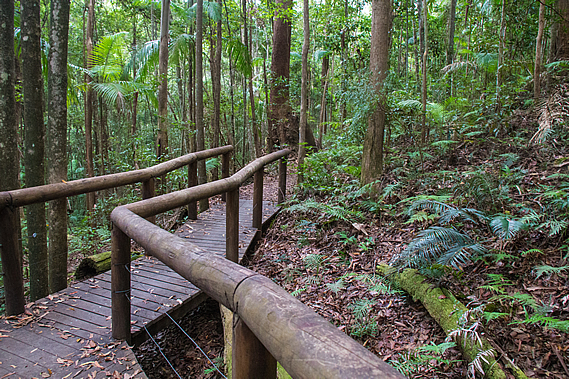
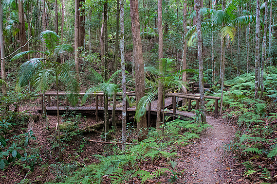
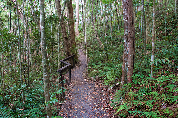
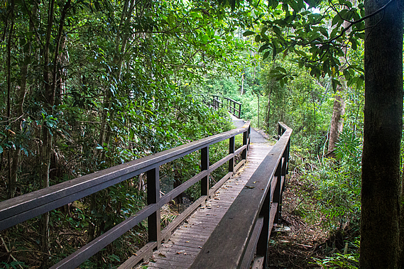
From the Narrows Lookout we returned to the main track and followed it for the final two kilometres through sclerophyll forest to Baroon Pocket. The lookout is quite popular, so the standard of the track suddenly improved in this section, either wide dirt track or boardwalk with wooden hand railing for the remainder of the track. The elevated boardwalks were built primarily to protect the habitat of the rare Australian marsupial frog Assa darlingtoni only found in the rainforests and wet sclerophyll forests of South East Queensland and northern New South Wales. It is about 2.5 centimetres long and perfectly camouflaged against the reddish brown soil. The male has a pouch on its hip where the tadpoles live after hatching and live there until they have morphed into frogs.
The rain had stopped falling now. The track was well above the creek passing through the palm rainforest heading around the back of a wide gully before heading out onto a spur. Near the end of the spur was a hollow tree with a bench seat set inside it.
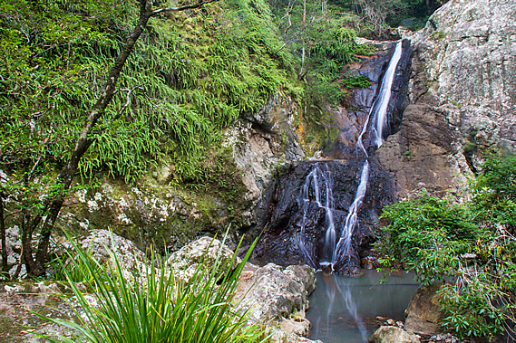
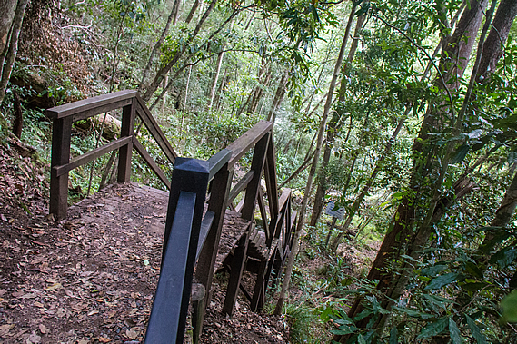
Shortly after the tree seat we reached another junction. A wooden stairway led steeply down the hill to a swimming hole in the Obi Obi Creek. The water cascaded down the rocky stream bed into a large pool surrounded by sharp craggy rocks. Looking upstream I could see a huge rock wall. This was the Baroon Dam, just a few hundred metres away, towering fifty eight metres above the valley.
The name Baroon is derived from Barung, the Aboriginal term for the local rat kangaroo that forages the forests here. They look like rats, but they have huge back legs allowing them to hop like kangaroos. There are a number of species of rat kangaroo, but the name probably refers to the very large rabbit sized Rufous rat kangaroo. These creatures are nocturnal and graze the forests in herds, though the animals are spaced well apart. We returned up the steep stairs to the main track and followed it through the thinning eucalyptus forest further around the hill and across a double bridge spanning across a cascading stream split into two with each bridge going to a small island.
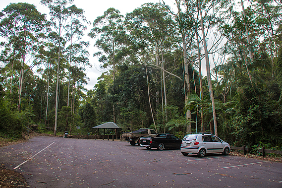
Once past the bridge, the track rose moderately for the final fifty metres to a large gazebo marking the end of the great walk. We had reached the main car park. The mobile phone reception here was quite weak, but we managed to check in on our friend who was about half an hour away, so we told him to meet us up at the dam.
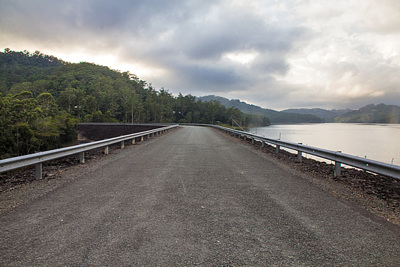
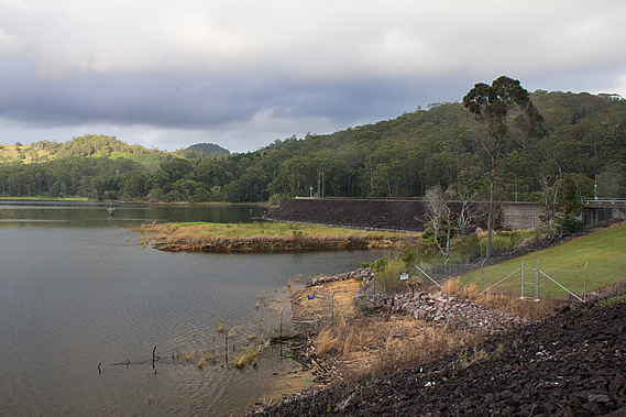
A concrete track steeply led up from the car park onto the top of the dam. From there we had sweeping views out across the lake. We followed the road along the dam, with contrasting views on either side. To our right the dam steeply dropped off into the forest where the Obi Obi Creek headed downstream. Several sulphur crested cockatoos were flying above the trees screeching. Large loose rocks covered the dam wall, looking like volcanic rubble reminding me very much of the darker slopes of Mount Ngauruhoe on New Zealand’s North Island.
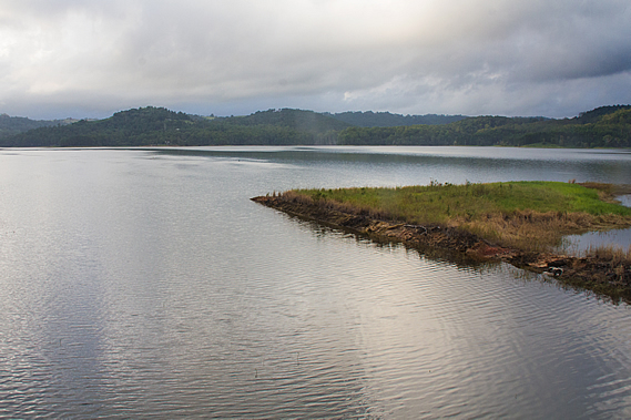
To the left the lake filled a large open valley that was once Baroon Pocket, where the Aboriginal people travelled from far and wide for the Bunya nut harvest. The dam wall under the road stretched out 370 metres across the valley standing fifty eight metres high. It holds about 716,000 cubic metres of water from a catchment of 72 square kilometres supplying part of the Sunshine Coast with fresh drinking water. What had once been the site of Australia’s largest gatherings is now submerged fifteen metres below the four by two kilometre lake. Shortly after the area was declared a refuge by the New South Wales government in 1842, the famous explorer Ludwig Leichhardt hiked through the area. He reported the small plain at Baroon Pocket was the rendezvous point for battles between the tribes, followed by the feasting of the Bunya nuts.
Two years later the 14 year old Tom Petrie travelled from Brisbane, which at the time was a fledgling colony, with a group of local Aboriginal people to Baroon Pocket. He described the gathering of about six hundred Aborigines partaking in the ceremony which lasted over a month. In a particularly good harvest the ceremony would last up to three months. They were catered for by a feast of nuts, plants and animals as they ran a political forum of the neighbouring tribes. For the six hundred people attending it was a time of celebration, where they shared tribal dreaming stories, sang, danced, played games and arranged marriages. Towards the end of the festival a huge fight broke out, but each tribe reaffirmed their friendship with each other and exchanged gifts of tools and ornaments before leaving. When all the visitors left, the local tribe stored the remaining Bunya nuts in mud along the banks of the Obi Obi Creek before walking across the range to the coast where they stayed for about a month eating the fish and fruit that was aplenty there. This allowed them to have a variable diet whilst the food resources of their homeland replenished itself after the stress of six hundred visitors.
Despite the loss of this culturally significant place, representatives from the Wakka Wakka, Githabul, Kabi Kabi, Jarowair, Gooreng Gooreng, Butchella, Quandamooka, Barrangum, Yiman, and Willi Willi indigenous groups continue to meet. There is nowhere to meet here with the loss of the Baroon Pocket. Instead they head inland to the Bunya Mountains, which, as the name suggests, contains a significant enough population of Bunya trees for them to continue their spiritual and cultural connections to their old customs. Fortunately Bunya Mountains is protected forever, so there will never be a repeat of what happened here. Following the formation of the Queensland Government, the land that made up the pocket was eventually subdivided into around ten farm plots between 1878 and 1887.
The farmers who lived in the pocket for nearly a century described the Obi Obi Creek as beautiful with sparkling waterfalls and cascading rapids between the large swimming lagoons. The soil here was very fertile allowing for fruit and vegetables to grow and many farm animals. Produce was carted out along the steep road up to Montville on top of the range, or to Maleny to the south near the headwaters of the creek. Towards the end much of the land grew kiwifruit, which thrived in the warm sheltered microclimate, 2040 millimetre per year rainfall and fertile soils of the valley.
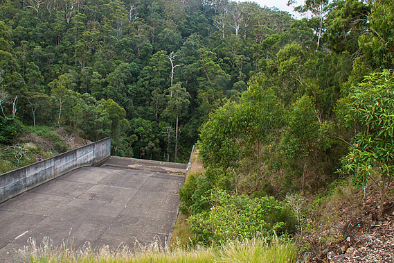
The dam wall was completed in 1989. The water is collected from the intake tower we could see. From there it flows through a 2.5 metre diameter tunnel for two and a half kilometres through the Blackall Range to a water treatment plant. From there the water is distributed around the Maroochy and Caloundra areas of the Sunshine Coast. The dam swept around towards the other side of the valley. The far side of the dam had a spillway for flood water when the dam is too high. A permanent runoff keeps Obi Obi Creek flowing. Although still cloudy the sun was beginning to come out.
We had reached the end of the destination at the dam car park. We rested here for a few minutes before our friend arrived picking us up and heading back along the dam to the steep road rising out of the valley heading into Montville, then back along the range towards our homes in Brisbane. |
||||||||||||||||||||||||||||||||||||||
|
||||||||||||||||||||||||||||||||||||||