|
||||||||||||||||||||||||||||||||||
|
||||||||||||||||||||||||||||||||||
Home > Treks > Sunshine > Day 4 > 4.3 |
||||||||||||||||||||||||||||||||||
|
||||||||||||||||||||||||||||||||||
|
I HAVE a particular fascination for little lost world pockets, where you discover a place tucked away in a hidden gully or atop a mountain, misplaced in geological time.
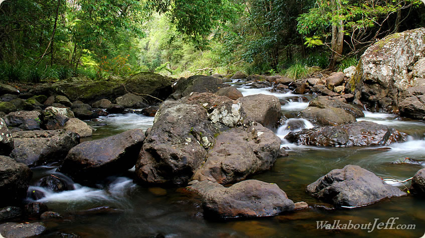
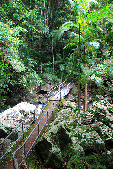
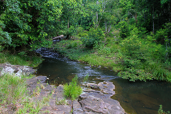
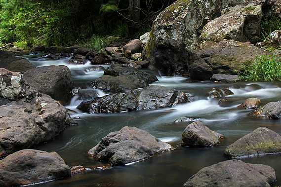
From the bottom of Kondalilla Falls we followed the track back to the junction, and crossed the concrete ford bridge across the rubble of huge moss covered boulders. Although the stream was running higher than usual, the water was almost completely concealed under the rocks. The ford itself had steel railing on either side to make for a safe passage across. The structure was built over several enormous truck sized boulders.
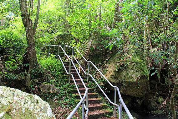
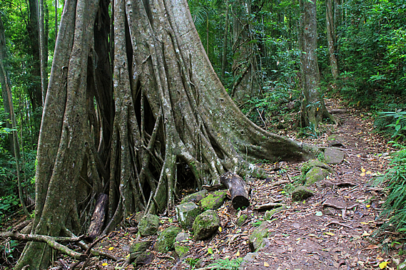
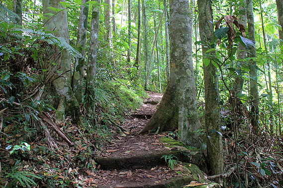
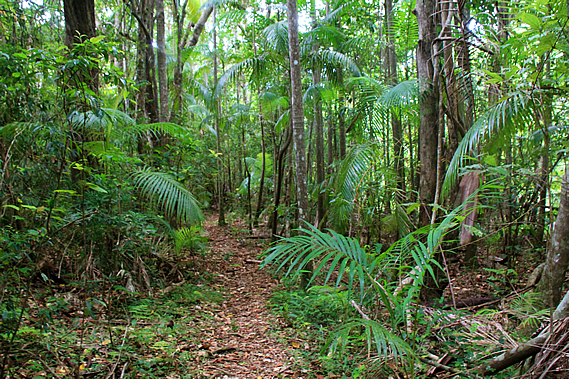
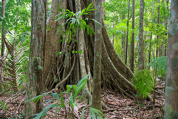
Once on the other side, a steep concrete staircase led through thick undergrowth over a small bluff and down another set of stairs to a fairly narrow dirt track heading across the face of the moderate slope to follow Skene Creek downstream through the dense rainforest containing over six hundred species of plant and animal, many of which were survivors of a completely different age many millions of years ago. Large boulders littered the forest floor having rolled down from the higher slopes of the gorge. Mosses and lichens covered the boulders and also the fallen trees helping the insects and snails to decompose them.
Surprisingly there wasn’t much leaf litter on the ground. All the rainforests I have been in to date have had a thick soft carpet of leaf litter covering the forest floor protecting it from erosion and providing a habitat for the small ground dwelling insects. Here there was not much at all. This was due to the huge metre long worms of the digaster genus. There are several different species of digaster earthworm in South East Queensland, but the ones here would have perhaps been the Digaster lumbricoides. These nocturnal creatures come out of their deep burrows at night, collect the fallen leaves and drag them back underground to eat. At the end of each night they clog the entrance to their tunnels with leaves. This explained the occasional pile of leaves sticking vertically out of the ground.
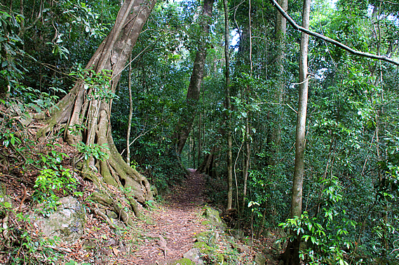
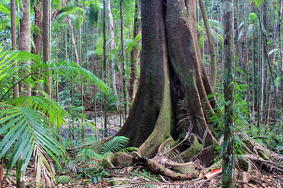
Huge strangler figs and buttressed trees towered into the sky in amongst the Bunya pines. Palm trees formed a middle canopy causing little sunlight to reach the rocky ground allowing the small ferns and mosses to flourish there. When looking closely at the ground, one realises there is an extensive variety of small mosses, filmy ferns and larger ground ferns. Cloud had covered the sky overhead again increasing the eerie darkness of the little rainforest tucked away deep in the gully. In amongst the Bunya trees was the Bolwarra (Eupomatia lauribo) with its distinctive zig-zag branches. These trees have been growing in this area for over eighty million years from when the dinosaurs were around.
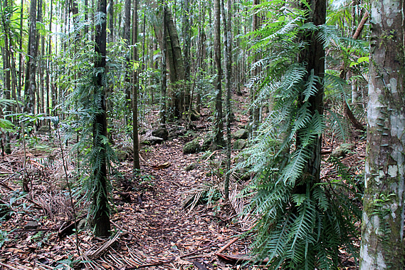
The smaller trees had a climbing fern growing on them, no doubt creating entire ecosystems in the dark subcanopy. The track reached a junction to the circuit heading back over to the rock pools above the falls. This type of rainforest covered almost all of Australia twenty five million years ago, after the basalt eruption that created the plateau. As Australia moved northwards breaking further away from Antarctica, the Southern Ocean expanded creating the circumpolar current that began to cool earth into a series of ice ages that continue through to this day.
The rainforest supplied an abundant food supply. January to March was obviously the bunya nut season, with enough to feed the local tribe every year, and during an abundant harvest, enough to go around all the visiting tribes too. Bush honey from native bees was plentiful at that time of year too. Following the bunya nut season was the fruiting season, where many fruits were available from palm trees and other plants, along with turkeys and pigeons. At the beginning of this season all the visiting tribes travel eastwards over the Blackall Range to catch fish and live off the abundant harvests of the Sunshine Coast. The local tribes would return here for the remaining fruits over early winter. August and September provided a supply of turkey eggs. Throughout the year they collected fish, yabbies and eels from the streams, and marsupials, lizards, snakes and echidnas from the forest.
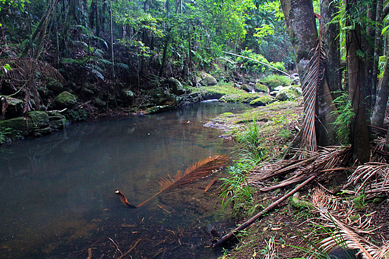
Occasionally the track would follow directly beside the stream. The clear water flowed gently between boulders into large pools of still water. As the track continued to head downstream the undergrowth began to thicken and the rainforest started to thin. Several runners suddenly appeared racing along the track towards Kondalilla, having run from Baroon Pocket on some sort of circuit. They passed us and disappeared as quickly as they had appeared.
A little later I brushed up against some native stinging plant causing my lower leg to painfully sting with the stabbing pain of needles for a while, but fortunately there was no immediate swelling or redness. There are six species of stinging tree growing along the east coast. One of these is the gympie gympie which can be lethal. Fortunately I was attacked by one of the less toxic varieties, but the neurotoxin it injected into my skin was painful enough. Towards the bottom of the valley the track rose along some broad steps over a small rise that would have perhaps been a river terrace at some time past. It followed the top of the terrace for a little while before descending into an open clearing.
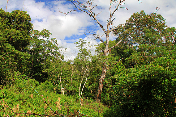
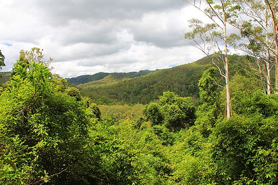
Blue sky was visible between the clearing clouds. The trees were spaced well apart allowing for regenerating vegetation to create a very thick undergrowth. Through the clearing I could see out to the Flaxton Ridge where we had stayed last night. This side of the ridge was partly cleared pastureland. From the clearing the track turned southward heading away from the creek passing the junction where it meets Obi Obi Creek. The track crossed the grassy flat at the junction to start following the Obi Obi Creek upstream. the green trees were well spaced.
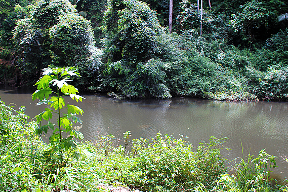
It was not long before we reached the Obi Obi Creek, a very long still channel of grey translucent water stretching up along the valley. There seemed to be little movement in the water despite all the rain overnight. The name of Obi Obi Creek is derived from Ubie Ubie, a well respected warrior chief of the Nalbo Clan who were based on the slopes of the other side of the Blackall Range in the first half of the 19th century. The clan was named due to their use of the hoop pine, where they constructed glue out of its gum.
After nearly half an hour we reached Flat Rock where we briefly stopped. Here the water ambled over a small rapid under a huge slab of rock. We sat down on the large block of rock for a few minutes. I checked the sting on my lower leg. There was still no redness or swelling and the pain had subsided to just a very mild sting. From Flat Rock the track began to ascend the young regenerating eucalypt forest over a small hill to bypass a winding Obi Obi Creek. The grass on either side of the track thickened and it was clear this section of the track hadn’t been cleared for a while. As we reached the top of the rise the trees opened out into large patches of grass which in some cases were almost entirely overgrown, leaving just a thin line through which the track ran.
There was the occasional view across the fairly wide valley. The rugged hills on the other side were covered mostly in regenerating forest. This whole area must have been cleared at some stage, then absorbed into the Kondalilla National Park when it was combined with Obi Obi National Park which would have begun soon. The government buying this area of land allowed the two national parks to be joined together. The track began to steeply descend passing some large ghost gums with the bark stripped to about two metres off the ground. A group of four men passed us going the other way heading at quite a pace no doubt to reach the Flaxton Walker’s Camp later today.
The descent took us through scrubby eucalypt forest before reaching the bottom of the valley in beautiful rainforest. There was a high concentration of palm trees down here. The Obi Obi Creek was just a few metres away cascading on the other side of the thick foliage. We found a spot near the end of the flat where we briefly stopped beside the stream for lunch.
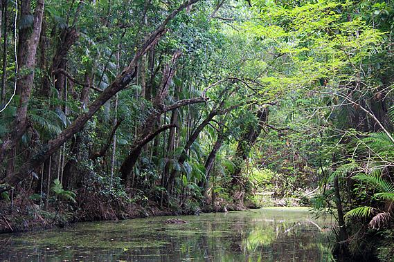
The water rushed over the large boulders under the overhangs of the large trees curling over it. The water was fairly clear given all the overnight rain. Perhaps not as much rain had fallen over this part of the park. Just upstream of the rapid a small stream flowed into the main creek. It was little more than a trickle, but upon heading a few metres upstream we realised this was just the slightest of overflows at the end of a long stagnant channel that had carried the main flow of the stream at some time past before a flood dammed off the end diverting the creek along its current path.
The still water of the channel looked mysterious with a row of trees overhanging about thirty degrees over the water. Returning to the main stream we stopped for lunch at some large boulders under an overhanging tree. We were making very good time with just a climb over the gorge before we reach the Baroon Dam. That will only take an hour or two and we had four hours before our scheduled pickup.
We relaxed as the water bubbled by, cascading through the gaps between the boulders in this secluded gorge, cut off completely from civilisation apart from the track that was hidden in the rainforest. The three camps we had stayed in were all on the ridges, so there had been little opportunity to hear the sound of rushing water. The camps had been set up on the ridges as they were more accessible and easier to maintain. There is a lot more wildlife in the rainforests, and the terrain in the gorges meant there were few natural terraces to establish a suitable campsite.
The sun quickly disappeared behind thick overhead cloud as we left the Obi Obi Creek and followed the thick rainforest, passing large trees and giant boulders having rolled down the side of the hill in the past. The track suddenly began an ascent, zig-zagging up the steep side of the hill at the beginning of the Obi Obi Gorge. The creek was well out of sight through the thick eucalypt forest. It was long moderately steep climb towards the top of the bluff as the forest started to thin and the clouds overhead quickly darkened showing signs of imminent rain as we headed out of the Cretaceous Lost World into the final leg of our journey. |
||||||||||||||||||||||||||||||||||
|
||||||||||||||||||||||||||||||||||