|
||||||||||||||||||||||||||||||||
|
||||||||||||||||||||||||||||||||
Home > Treks > Sunshine > Day 4 > 4.2 |
||||||||||||||||||||||||||||||||
|
||||||||||||||||||||||||||||||||
|
FROM the Kondalilla Lookout we returned to the main Picnic Creek Circuit track and continued following it for about a hundred metres before reaching a junction to what would become the most interesting and spectacular parts of the hike. The main track continued around the hill heading back towards Picnic Creek to eventually close at the stairs above the bridge.
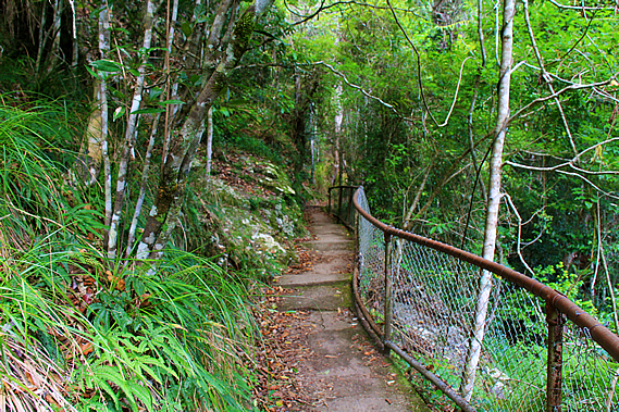
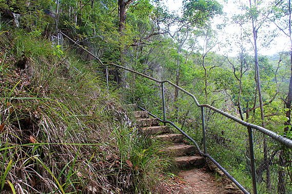
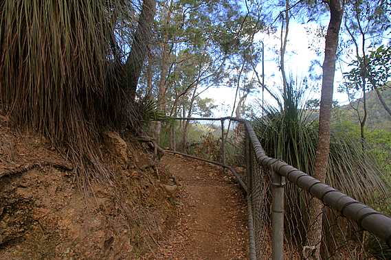
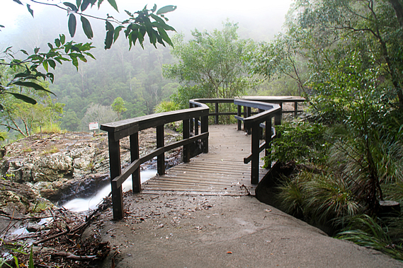
From the junction the great walk turned sharply to the right to begin descending towards the creek. The terrain suddenly steepened and a steel netting fence was on the downhill side of the track, sealed with concrete quite some time ago, long enough to show significant erosion. The forest floor changed from soil to solid rock with the vegetation perched on it growing in any cracks it could find. The track zig-zagged steeply down the rock face with the occasional flight of descending concrete steps similar to those we had encountered on previous days. There were over a hundred steps down to a junction to the rock pools at the top of the waterfall. The bank of cloud I had seen earlier had by now covered the sky overhead.
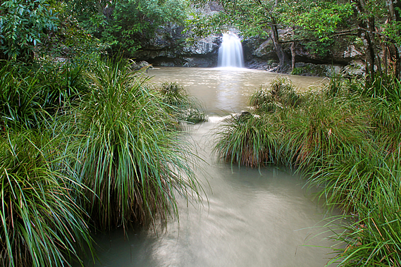
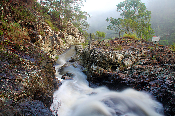
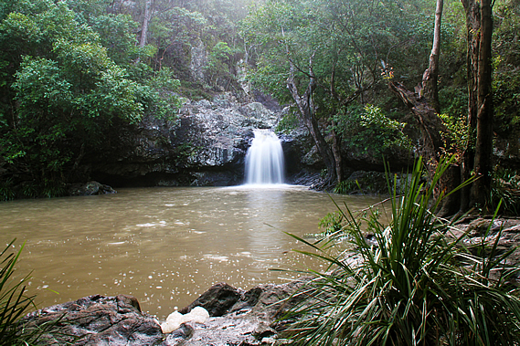
The track to the left led to a nearby rock pool. This was normally a very popular (and therefore crowded) swimming hole at this time of year. By chance a large group of people were leaving just as we arrived leaving only our group. This was perfect timing for photographing the pool with its small waterfall plunging two metres into it. Somewhere upstream Picnic Creek flows into the slightly larger Skenes Creek before plunging into this pool. Skenes Creek is named after the Skenes family who settled in nearby Montville in 1887 with ten other families. No doubt they were the settlers who discovered this pool.
The water was running quite strong into the waterfall. I have been here in the past when the water was no more than a trickle. Fortunately last night’s rain had swollen the creek enough to produce a solid waterfall plunging into the large pool. The water in the pool was dirtier than usual though. From the pool the water flowed through a channel under a low bridge and rushed in twisting cascades to the edge of the cliff over which the Kondalilla Falls dropped into the valley below.
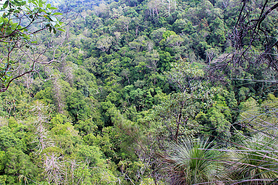
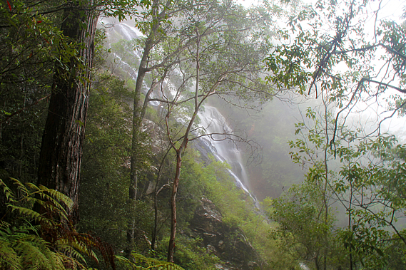
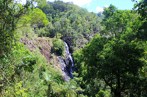
Kondalilla in the local Aboriginal language means rushing water, perfectly describing the cascades crossing the jagged layers of rhyolite and leaping into the softer layers below. By now we were well below the dark hard layers of basalt that had been laid in the eruptions of 28 million years ago, but now venturing through more volcanic layers of a much older eruption from an eruption that had occurred around 210 million years ago in the late Triassic. The cloud had descended over the ridge and quickly dropping into the valley, creating a damp fog. It briefly lifted as we continued along the side track up to a small lookout over the valley. Fortunately the foggy cloud cleared enough for us to see down to the bottom of the valley about a hundred metres below us.
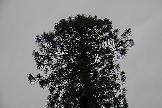
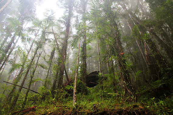
Looking into the valley we could see a stand of Bunya Pine (Araucaria bidwillii), a rare remnant of the great forests covering Australia and much of the rest of Gondwanaland over a hundred million years ago. This is the last of two surviving species of the Aracaria which was a widespread tree of the Mesozoic, appearing in the Jurassic at about the time the rhyolite and sandstone making up much of South East Queensland was deposited. They generally grow to 35-40 metres and will live for around five hundred years. Fossils of these trees from the Jurassic have been found in South America and in Europe.
The other surviving Araucaria is the Araucaria araucana, commonly known as the monkey puzzle tree. It is native to southern and central Chile, and to Argentina. The Bunya pine is often referred to as the false monkey puzzle. The Bunya pine produces large 20-35 centimetre diameter, soft shelled cones every few years. It is commonly accepted they fall every three years, but the actual germination is not so regular being anything from two to seven years. When the bunya nuts were ripening, the local tribe sends out messengers to the other tribes over hundreds of kilometres to let them know about the upcoming Bunya festival and for the visitors to meet at specific sites. Although the Bunya tree grew throughout South East Queensland, they only ever grew in high enough concentrations to support the corroboree in Baroon Pocket, and inland in the Bunya Mountains. They would be gathered from as far away as Charleville, Dubbo, Bundaberg and Grafton.
Somehow these trees know when to produce seeds to enable them to emerge in optimum climate conditions, or perhaps to minimise the chances of being affected by bushfire. They fall to the ground intact, their large size making them potentially lethal. When they hit the ground they remain there until eventually naturally splitting to disperse the 3-4 centimetre long seeds. Sometimes large birds like cockatoos break them open with their beaks. This seems to be an awkward method of seed dispersal indicating they had evolved to be dispersed by large herbivorous dinosaurs. When they died out 65 million years ago, the large mammals took over spreading the seeds. The cones take a long time to grow. The trees pollinate in September and October. The cones take seventeen to eighteen months to form and fall between late January and early March, during the height of the rainy season here.
The large native mammals died out in the first thousand years or so of Aboriginal settlement. The task of dispersing the seeds now seems to have been handed over to the bush rats and the short eared possums. They break the huge cones and carry the nuts to their stores along the ridgelines above the trees. New trees tend to germinate along ridgelines where the nuts are buried. The Aboriginal people never camped amongst the Bunya trees as they were considered sacred. It was also too dangerous with the heavy cones falling from the trees. The trees were so sacred some tribes forbade the cutting of them. Certain men of the local tribe were allocated particular trees. They had exclusive harvesting rights over the trees. The men climbed their trees using a carefully selected piece of vine. It had to be exactly the right length and thickness. They looped one end of the vine around their left hand, threw the other end around the tree and grabbed it with their right hand. They climbed by springing up the tree, leaning back so the vine supported his body weight and created enough friction against the tree to be sturdy. They could climb the tree quickly to knock ripe Buny’yi, as they called it, to the ground.
They would then transport the nuts to Baroon Pocket where it was roasted for the gathering. The seed take about six months to germinate. It initially forms an underground tuber before developing roots after about a year. Then aerial shoots appear as a dark brown rosette and turns green only when the first stem branch appears. The young leaves are soft, but these harden as the tree grows, eventually becoming very hard and sharp. The trees are difficult to cultivate, but once established they are rather hardy, growing in gardens as far south as Hobart and Christchurch. They also successfully grow in the northern hemisphere as far north as Ireland.
The Aboriginal people ate the nut either raw, roasted or boiled. They were also ground into a paste which was either eaten raw, or cooked in hot coals to make a form of bread. At times they were submerged into the mud of running creeks and left to sprout and ferment, eventually to be dug up and eaten as a delicacy. The nuts are said to be very nutritious, having a unique flavour resembling chestnut and starchy potato. When boiled in water, the nuts turn the water into a red nutty tea. The Aboriginal people also ate bunya shoots and stripped some of the bark as kindling.
In modern times, Bunya nuts are sold in grocery stalls around rural areas of southern Queensland. At least two companies use the Bunya timber for the soundboards of their acoustic guitars. Cabinet makers have also used the timber for over a hundred years. The scientific name is credited to English botanist John Bidwell who was famous for documenting flora in New Zealand, but moved to Australia in later life and discovered several new species, including the Bunya pine in 1843.
Before European settlement, the Bunya tree was widespread over South East Queensland. Clearing by settlement has reduced their distribution to a few small pockets on the Blackall Range, Bunya Mountains, and upper Brisbane and Mary Rivers. There are also a few small pockets about a thousand kilometres further up the coast. The fog quickly descended again as we returned to the pool. The track did continue to meet the great walk and return up the other side to complete the Kondalilla Falls Circuit.
Crossing the small bridges over the creek we could see it dropping over the edge of the cliff in the mist down the Kondalilla Falls which we couldn’t see. The danger of the sheer drop was in sharp contrast to the tranquil pool on the other side. By now two more groups had arrived at the pool dipping in it to cool off. We returned to the junction and continued following the Great Walk. The track quickly became very steep descending a long staircase down an almost vertical bluff. By now thick cloud had completely enveloped us. The tall forest impossibly clinging to the steep terrain looked eerie in the thick mist. It was so thick I couldn’t see across to the other side of the gully, but at one point in a small clearing I could see across to the waterfall where the white water was tumbling down the rock face swirling the warm damp mist.
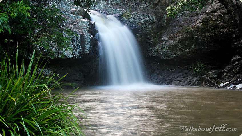
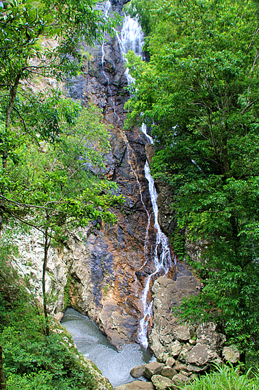
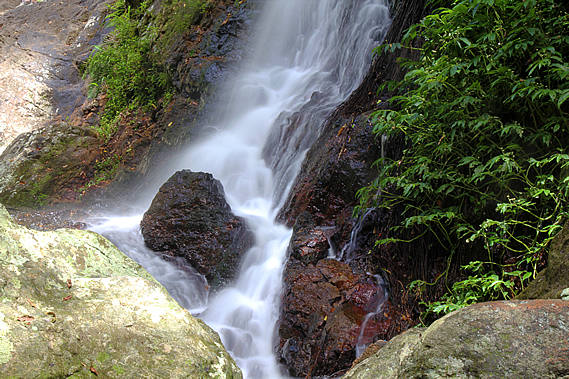
The track headed further out into the gully as it continued steeply descending the stairs. The thick bank of fog suddenly cleared as quickly as it had earlier arrived. At the next viewpoint there was some blue sky visible and the waterfall was completely clear of fog. The waterfall cascaded down the right hand side of the rock wall, leaping from the hard layer of basalt dropping into the softer rhyolite layers below. At this viewpoint I could only see the top half of the waterfall. The rest of it was hidden behind the dense foliage. The stairs stopped and the track continued to drop moderately to a hairpin bend doubling back towards the waterfall. It returned almost right back to the cliff face where it doubled back to head downstream again. By this point we were about thirty metres above the bottom of the waterfall. From here we could see all but the very top of it. The waterfall cascaded ninety metres down the solid rock face into a small grey pool sweeping back into the cliff. From there Skene Creek flowed down the valley.
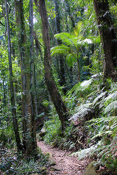
We continued following the track downstream as the sun came out above the canopy and the forest changed to dense rainforest with its bright green undergrowth and piccabean palms. Once near the bottom of the valley, a stone staircase led down to a junction where the main track crossed the stream over a concrete ford structure whilst a side track headed upstream to the bottom of the waterfall.
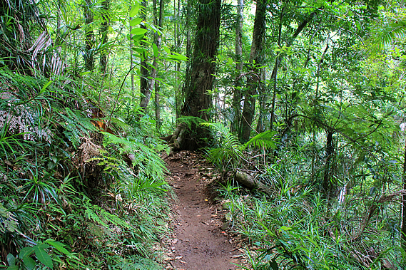
We followed the side track which quickly became a bit of an obstacle course clambering over roots and boulders. That only lasted a few minutes though as we reached the waterfall, where enormous boulders flung down the cliff by tempests past blocked the view of the pool we had seen earlier. We found a quiet spot with a view of the bottom of the waterfall to rest. There were a few people nearby exploring the waterfall. After a couple of hours walking it was nice to relax at the bottom of the precipitous gorge under the rushing waters streaming down the falls from high above, hearing the water falling before plunging between the rocks from pool to pool as it headed downstream. |
||||||||||||||||||||||||||||||||
|
||||||||||||||||||||||||||||||||