|
||||||||||||||||||
|
||||||||||||||||||
Home > Diaries > 2022 > 951 |
||||||||||||||||||
|
||||||||||||||||||
|
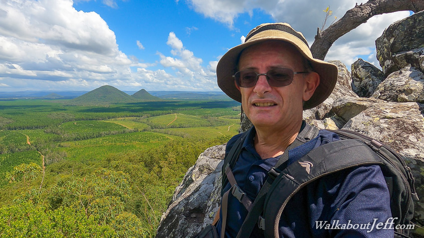
ARRIVING at Beerburrum Village shortly after sunrise, I followed the track towards the summit of Mount Beerburrum. The new trailhead track was closed due to storm damage from the recent floods, but arrows pointed the way up a couple of gravel roads with a climb up a grassy bank passing the old hospital led me to the old car park from where the summit track and the Yul Yan Man Track which I followed last year starts from. I followed the steep concreted trail up to the summit of Mount Beerburrum where several runners were resting. I climbed up into the tower to look out over the other peaks of the Glasshouse Mountains, and across the glimmering Pumicestone Passage to Bribie Island. Low cloud partially covered the sky catching the early morning sunlight. I headed back down the steep track back into Beerburrum town from where I headed across to the Tibrogargan climbers' carpark expecting the main Tibrogargan carpark to be full already. From the carpark I followed the short forestry trail to near the base of Mount Tibrogargan from where the Trachyte Circuit crossed. I followed the circuit anticlockwise crossing Tibrogargan Creek over the large stepping stones which had not been moved during the big flood. Once over the other side I continued following the track briefly stopping to look into the cave dropping vertically from its caged entrance. The track continued heading around passing the start of the Soldier's Settler's Trail heading back to Beerburrum. I continued heading straight ahead as it started ascending to the base of the Trachyte Range, extending northward from Mount Beerburrum. I reached the junction to the Yul Yan Man Track, and followed that for about fifteen minutes to the start of the very steep rise to the top of the range. From here I turned back and returned to the Trachyte Circuit heading uphill to the top of the low saddle and continuing a short climb up to the Jack Ferris Lookout at the northernmost point of the range. After resting at the lookout, I headed back down to the junction and continued following the Trachyte Circuit until reaching a firebreak. I turned along the firebreak and followed another one heading towards the base of Mount Tiberoowuccum, a short hill with a rock tower pointing in this direction. The rock face seemed to be an impossible climb from this side, but should be reasonably accessible from the other side. Another firebreak turned off to the left once I reached the base of Tiberoowuccum. I followed this rough trail about a quarter of the way around the hill until reaching another rough firebreak trail heading up the hill. I followed this trail heading moderately uphill as a small group passed me also heading towards the summit. The track steepened to make for a bit of a scramble before the track eased off at a junction with another walking track. From here the narrow walking track was an easy walk along the spur despite parts of it being a little overgrown. It was not long before I reached the summit of the round hill in amongst grass trees and gnarly scrub. I stopped here briefly before continuing along the narrow trail. From here the terrain quickly became very rocky as the track negotiated its way over and under the enormous boulders. The other group passed me having successfully reached the summit of the rocky end. The trail descended to a low saddle between the main hill and the rocky outcrop, which stood a little higher than the flat summit now obscured in the bush behind me. A steady scramble up the rock led to the small summit covered in short scrubby trees exposed to the elements. From here I had great views back along the Trachyte Range to Mount Beerburrum and The Twins to the south, and to the looming face of Mount Tibrogargan nearby to the east, and to the relatively distant mounts Ngungun and Coochin to the north. I didn't stay at the summit long at all, opting to carefully descend to the saddle below the rock and up another rock to rest for lunch. Following lunch I returned along the narrow track passing the short summit before reaching a track junction. Another track led to the north, so I followed this down the hill to a firebreak which quickly ended at a sealed road. I followed this road for about a hundred metres before reaching the Tibrogargan carpark and picnic area. After a brief stop at the picnic area, I followed the Tibrogargan Circuit around the base of Mount Tibrogargan before heading back to the climber's car park. From the car park I followed the road up to Landsborough, then up the Blackall Range to Maleny where I will be staying the night. From the town centre I discovered a track leading from the library to a picnic area in a bend in the Obi Obi Creek. I returned to the library and found the nearby Maleny Trail which I will be following downstream tomorrow morning. With a bit of time left before sunset, I followed the track upstream following a boardwalk above Obi Obi Creek for a couple of hundred metres to the Maleny Showgrounds from where I watched the sunset before returning to the town centre for the night. |
||||||||||||||||||
|
||||||||||||||||||