--- Archive files ---
Home > Travels > Masai Mara > 1 |
A Continent Tearing Itself Apart
IT WAS almost eight o'clock in the morning when a minivan pulled up outside the hotel. An overweight man in a pale green shirt (almost as bright as the pale green shirt worn by my tour guide in Valparaiso last year) walked in and waited at the counter as the receptionist was serving another guest checking out. He turned to me seeing my pile of bags and asked me if I was Jeff. I said yes.
He introduced himself as Joseph, and then got the attention of the receptionist. He asked me if I have my vouchers yet. No I hadn’t. I only had my itinerary which I showed him.
The receptionist gave him a package. He turned to me saying "this could be helpful". He opened it and sure enough there were my vouchers and form – the ones that should have been addressed to me to collect the other night when I had first arrived here at the hotel in Nairobi. I filled in my insurance details and gave him the information he needed. I’d been on enough tours already to know the drill. With paperwork done, we took my bags and went to the van and put them in the main section. I noticed there wasn’t anyone else in the van so I asked if I could sit in the front. He was happy with that and moved his gear off the front seat to one of the other seats further behind.
Now I finally thought we were on our way, but the security guard outside asked me for my receipt. What receipt? Apparently I was supposed to get one when I checked out. I realised then that the receptionist at the front counter had assumed I was only going out for the day when I handed in my key, so I returned inside to the counter and said I was from room 503 and had actually checked out and could I please have a receipt to hand to the security guard.
She quickly wrote me a receipt and gave it to me. I hurried back outside and gave it to the security guard and jumped in the van.
The outskirts of Nairobi |
Now we were finally on our way.
Joseph then properly introduced himself and outlined the itinerary. Then he mentioned that I was the only one on this tour. This was completely different to every other tour I had ever been on where there were at least ten other tourists from all around the world (though mostly from Australia) travelling with me. It was a surprise for him too as he always had a group of between six and twenty passengers on his tours. He was happy to stop for any photo stops that I needed. There was no hurry to get to where we were going today. The safari was not until tomorrow and we had all day to get to our destination today.
I showed Joseph my flight itinerary and guaranteed he would get me back to Nairobi in time to catch my flight from Nairobi to Kilimanjaro in two days’ time..
Having been born and bred in New Zealand, I’ve always had a strong interest in geological processes. New Zealand is a most fascinating place being a continent split in two by the ring of fire and both sides sunken a good kilometre beneath the surface of the sea. Only the scab at the interface now pokes above the surface, covering about eight percent of the continent.
Today we were heading towards another spectacular anomaly tearing the African continent apart, but despite all the research I had done for this trip, I had not been expecting it. How could I have missed something so blatantly obvious?
Near the edge of the rift valley |
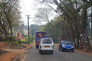
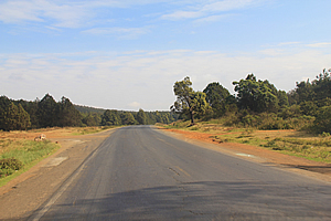
We slowly headed out of Nairobi, going with the struggling erratic flow of traffic congestion. We had a few near misses, but Joseph was a very good driver and somehow we got through the chaos. Most of the housing and shops in the area were very dilapidated though not as bad as say in Cambodia. Eventually we came out onto a well maintained highway with minimal potholes. This was a nice change to the poorly maintained roads in the city. At this stage I had no idea how high we were above sea level, only that we were quite a long way inland and it was quite hilly here. The road went up and down, but seemed to maintain altitude through the broken forest. We were driving directly behind a small van that was blowing so much smoke that we couldn’t see ahead of us. Thankfully Joseph’s driving expertise got us through and he found a space to overtake the van.
Much of the highway had two metre high concrete barriers down the centreline. I imagined this would be one effective way of preventing illegal overtaking or otherwise crossing the centreline. Soon we were away from the city passing through farmland and the barriers along the middle of the road stopped. There were a lot of people walking along the side of the road. Some were carrying sacks of what appeared to be spuds, and others were hitch-hiking.
Joseph said “anything you want to know, please ask. If I know the answer, I will tell you, if I don’t, we can discuss.” That was fine with me.
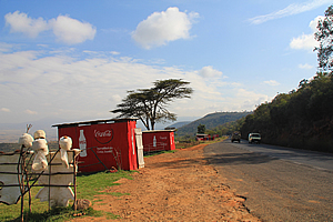
Small shop perched at the edge of the rift valley |
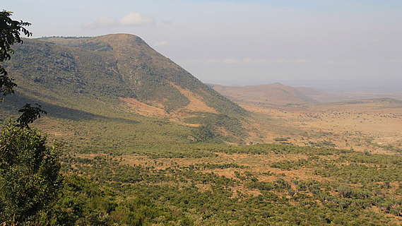
After about an hour the road started to go noticeably uphill for a couple of minutes before going over a pass and heading downhill down the side of a long straight slope. It reminded me of coming down the Golden Bay side of the Takaka Hill in New Zealand, though not as steep. Joseph announced that we were entering the Rift Valley and we will be stopping shortly for a photo stop.
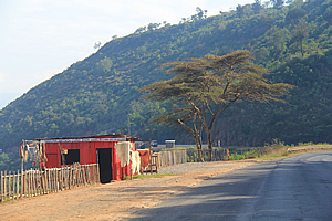
There were a number of shed like stalls perched along the edge of the road, with hundreds of metres drop down a thirty degree slope to the bottom of the valley below us. We pulled in at these markets and I got out to photograph the amazing view. The sun was shining now, but the valley was quite hazy. There was a sign saying we were 2140 metres above sea level here. Gosh, I didn’t realise this area was so high. No wonder Nairobi had been so cold. The city is over two thousand metres above sea level making it at least twelve degrees cooler than at sea level. No wonder Nairobi had felt so cool for an equatorial city.
Shops at the edge of the rift valley |
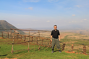
I managed to get quite a few good shots of the rift valley from standing behind a rickety wooden fence at a small lookout known locally as the Twiga View Point. There were several displays of hats, horns and other merchandise hanging on dead branches put in place inside a couple of old tyres sitting around. One of the stall owners came out from nowhere to attempt to sell me his wooden carvings at a totally unreasonable price so I thought. One was an interesting plaque showing some of the hills poking out of the plains below me. He pointed out these hills. I would have actually bought one if he had not been so pushy wanting to charge me twenty dollars – it really was only worth one or two dollars.
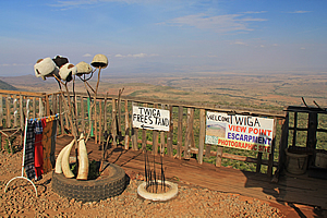
Wares for sale |
I left the sales man and found another one inviting me into his shop. Like all the others, this shop was quite a very small crude corrugated iron construction even smaller than my garden shed. It had no door, but there were a number of shelves displaying interesting wooden articles, none of which had price tags on them. I had by now completely lost interest in buying anything.
I left the shop and walked a few metres to another small lookout point to get some solitude. It would have been very peaceful up here had it not been for all the trucks driving past heading up and down the long highway. I looked out over the thousand metre deep valley to the distant hills on the other side only just visible through the dust haze. I realised this reminded me of one place where I’d really like to go, but there is no way that I could ever get there – no one has ever been there yet and no one would be likely to get there in my lifetime. This place is the biggest canyon and rift valley in the solar system, Valles Marineris on Mars. It is six thousand kilometres long, up to four hundred kilometres wide, and nine kilometres deep. This rift valley was Earth’s closest resemblance to Valles Marineris.
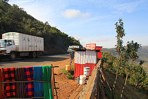
Busy road |
Now many people would be quick to correct me in saying that the Grand Canyon in Arizona, USA provides a much better representation of Valles Marineris. Wrong. The Grand Canyon is very deep and narrow, and carved out by the Colorado River flowing through it. Valles Marineris on the other hand doesn’t have (or ever has had) a river flowing through it. Recently they have found evidence of liquid water flowing very recently in numerous areas, but none of them were in Valles Marineris.
At the edge of the rift valley |
Unlike the Grand Canyon, the bottom of Valles Marineris is very wide and quite flat. It is believed to have been formed as a rift valley when Mars’ core was fluid enough billions of years ago for the surface to move as continental plates as currently found on Earth.
The rift valley is in the process of splitting Africa into two protoplates – the Somali plate to the east going into the Indian Ocean and encompassing Madagascar, and the Nubian plate to the west. I was at the edge of the Somali plate. The rift zone contains a number of volcanoes where the plate has split. This includes Kilimanjaro and Mount Kenya.
As we drove off, Joseph explained that the rift valley extends some twelve thousand kilometres from Russia down to Botswana. The depression it creates contains numerous salt lakes including the Dead Sea in Jordan, Israel and Palestine which is the lowest point of land in the world.
There were several trucks parked by the side of the road, broken down from not having been able to make it along the long drive up the mountain. A lot of the trucks we passed were very old and blowing thick smoke out the back indicating they were not as well maintained as they should be. No wonder so many of them were breaking down.
The side of the ridge was covered in thick scrub. No doubt it was too steep here to turn into arable farmland in this fairly arid area. Several faces of vertically columned rock beyond the bottom of the ridge marked the start of the Masai Plain, which I now couldn’t see the other side of now due to the dust in the air. At either side of the valley is a fault line, so I asked Joseph if they get many earthquakes here. He said they only have small ones. Then to my surprise he asked me if I knew what causes earthquakes.
This was clearly a question we could “discuss” rather than a question he could answer.
To save him having to “discuss” it with any future tourists, I explained to him that Earth is covered by a series of solid plates that sit on a core of liquid rock. Convection heat creates currents in the liquid rock which rubs against the surface plates causing them to break apart and move. Earthquakes occur at the plate boundaries when they suddenly move against each other to relieve stresses. I explained there were fault lines on either side of the valley, so there must be earthquakes.
The rift valley is actually a zone where the African Plate was starting to get torn apart. In millions of years’ time they will have parted enough for the ocean to flood in as it already had done further north with the Red Sea separating the Arabian Peninsula from the rest of Africa.
A similar phenomenon happened about two hundred and fifty million years ago. Another rift valley formed between what is now Africa and Europe, and the Americas. They split off Laurasia from Gondwanaland, creating the Atlantic Ocean in between when the sea flooded the valley. Now they have been separated by a good three thousand kilometres.
A similar thing is happening here. East Africa – along the eastern side of the valley, will separate from the rest of Africa and will move along with Madagascar north eastward to eventually collide around India or Pakistan. It is uncertain where the rest of Africa will go, but one thing is certain. It is currently moving northward colliding with Europe. This is causing the Mediterranean Sea to compress and eventually turn into a mountain range as the plates collide. After that who knows? Believers of the Pangaea Ultima theory say West Africa will collide back with East Africa eventually closing the rift valley again, whereas believers of the Amasia theory say the Atlantic Ocean will close. Both theories are plausible, so who knows?
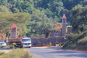
Church at the bottom of the hill |
We continued descending towards the bottom of the valley. The vegetation changed. No longer were we going through regular forest, but we were now going through irregularly distributed trees. There were the flat topped acacia trees. There were also candlestick trees. These looked like huge cacti with multiple branches sticking straight up like candlesticks some five to ten metres high. I had never seen trees like this before. We were also passing the first hints of civilisation now. There were a couple of crude stalls where one or two people were selling things and they had very smoky fires burning nearby, perhaps to cook whatever it was they were selling. There was also a tiny stone church in one of the gullies, almost looking castle like. It was constructed of grey boulders and had rust red trimmings around the bell tower. A simple red spire towered a bit squat to a plain apex. The belfry tower had wooden scaffolding around it. There were a couple of corrugated iron sheds surrounding it indicating some renovation work was going on.
<< Previous | Next >> |
|
||
About this Page
|
||
|
|
|
Where is Walkabout Jeff? |
|
|

|
|
What is happening in Walkabout Jeff's hometown?
|
|
|

|
|
Who is Walkabout Jeff?Any normal person's idea of going out involves going to the local pub for a drink with a few mates. Walkabout Jeff isn't normal.
|
|
|

|
Follow Walkabout Jeff |
|