--- Archive files ---
Home > Travels > Titicaca > 5 |
The Compass Works Well, but the Engine Splutters
BEFORE today I have never sailed across a freshwater ocean before, and I’ve certainly never sailed in very high altitudes at nearly four kilometres above sea level.
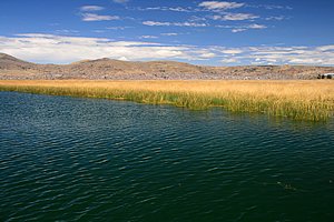
Reeds growing out of the dark lake |
The boat chugged asthmatically along the widening channel. The village soon gave way to free standing reeds growing in the black water. No doubt some of these reeds are harvested to help maintain the villages, but it was nice to be back in amongst nature with the city in the backdrop of parched hills in behind.
The colours were amazing though. The reeds poked out of the intensely dark green water in bright yellows matching the strong yellow and orange tones of the sandstone hills. The thin sky above was a very intense blue colour broken only by the occasional lenticular cloud. Although the clouds were high, they seemed deceptively low thanks to our high altitude. Sometimes the water would go very shallow with green algae just below the surface growing on the base of mud a metre or two below. We were going too slowly to churn up any mud.
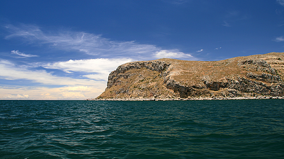
Arid mountains rising beside the lake |
I recalled from the earlier commentary this morning that the guide with the long hair said the air up here was very thin, so therefore the boat was very slow thanks to little oxygen to mix with the fuel in the engines. He also mentioned this was an excellent place for a ship’s compass. Lake Titicaca has the strongest magnetic field anywhere on the planet. I deduced from that the crew definitely knew where were going but didn’t have the stream to go there very fast.
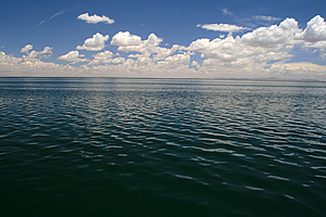
The dark cold waters of Lake Titicaca |
The water deepened again apart from the odd algae patch. We then turned and left the channel heading out very sluggishly across the lake. It was calm out here in the cold air, with the only swell being large laminar ripples on the surface. We headed towards a number of small islands out from the coast, following part of the mainland to the right.
I think most of the others were finding it a bit slow. We were all on the top deck. The couples were snuggling up to each other and most of the others were reading. One of the young ladies was writing in her travel diary. I was photographing the amazing scenery.
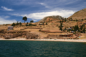
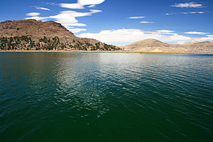
Village beside the lake |
The colours out here were spectacular. Pablo said we should normally be able to see the main dividing range of the Andes from here, but they were covered in fluffy clouds today. Maybe they will clear.
We were floating on nearly nine hundred cubic kilometres of water. It is the largest lake in South America. Twenty seven rivers flow into it, and only one flows out. The river that flows out runs into another lake which does not drain at all. This vast body of water evaporates in the arid climate. Ninety percent evaporates directly from the lake thanks to the very strong sunlight and strong winds.
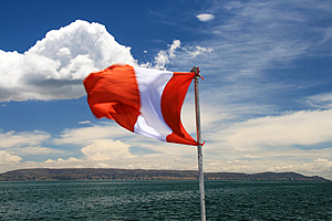
Flying the Peruvian flag |
The lake level has been dropping in recent years. Between April and November last year it had dropped 81 centimetres. Recent summer rainy seasons have been short and the glaciers in the mountains on the other side have been retreating reducing the inflows.
We chugged along very slowly. I noticed there were other tour boats heading in the same general direction as us. Although they were too travelling slowly, they overtook us. It seemed we had the slowest boat on the lake adding to the torture of it all. Perhaps the whole thing about there not being enough oxygen to power the boat was a bit of a crock. After all our bus yesterday had operated at altitudes up to over 4300 metres without any dramas at all.
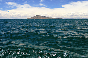
Taquile Island |
To our right were some headlands with small towns in the valleys in between. This was still part of the mainland. Most of the land here would be farmed. There were a few small row boats in amongst the reeds growing in the first hundred metres offshore. Where there were no reeds there was a white and grey beach of boulders up to where the grass grew. The beaches indicated to me that this area is prone to severe storms with the capacity to create quite a swell.
To the left in the distance were a number of islands. The waves in the water were starting to show some turbulence with the tops being quite pointy now. We passed a large rocky headland which reminded me of the rocky headlands of both Lyttelton and Akaroa harbours near Christchurch.
Once past the headland, we were out in the open water riding gently over the low swell heading towards an island.
<< Previous | Next >> |
|
||
About this Page
|
||
|
|
|
Where is Walkabout Jeff? |
|
|

|
|
What is happening in Walkabout Jeff's hometown?
|
|
|

|
|
Who is Walkabout Jeff?Any normal person's idea of going out involves going to the local pub for a drink with a few mates. Walkabout Jeff isn't normal.
|
|
|

|
Follow Walkabout Jeff |
|