--- Archive files ---
Home > Travels > Titicaca > 6 |
Island where old Men Knit
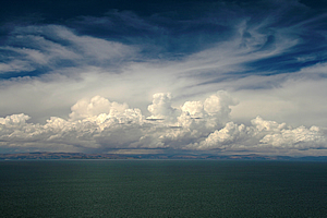
AFTER about three hours motoring outward across the lake from Uros, we were still less than half way across Lake Titicaca. The city of Puno where we had come from was now 45 kilometres behind us and just slipping below the horizon. Ahead of us rose a small barren island steeply rising out of the sea. Its steep slopes had a scattering of windswept trees amongst the coverage of brown grass. This remote island seemed at first to be an unlikely destination, but a destination with an interesting history.
Jetty on the island |
Once a farming settlement dating back many centuries to pre-Incan times, Taquile Island was taken over during the Spanish inquisition and used as a prison by the colonists. The isolation of the island ensured it remained a prison until the early twentieth century when it was finally abandoned. The island remained barren and uninhabited until in 1970 it was granted to the indigenous Taquileans who had been exiled from it for nearly five hundred years.
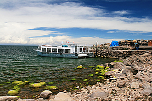
We sailed around the cliffs to the far side of Taquile Island where we spotted some evidence of civilisation. Then out of nowhere we suddenly saw a jetty ahead of us sticking out into the lake. We approached the jetty and secured the boat to it.
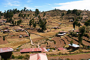
Terraced farmland from pre-Incan times |
Upon leaving the boat we walked along the heavily weathered but otherwise very solid timbers to the end of the jetty above the very rocky beach. The rocks were mostly barren apart from those very close to the shore which were covered in green algae. There were a couple of other boats tied to another jetty about a hundred metres from our jetty, but this side of the island seemed to be too exposed for any boats to permanently moor. There were a few pieces of plastic rubbish along the shoreline, but otherwise it was was a very clean beach.
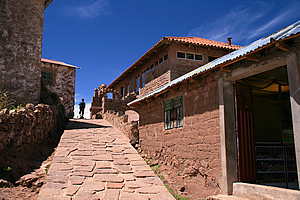
Steep path to the village |
A rough path led from the beach along a stairway heading up the hill. We followed the trail slowly. We could have climbed it quickly, but at this high altitude at 3800 metres we had to take it carefully. As we ascended we saw a dinghy tied up to a rock on the shore further along the coast. It seemed to be floating above the dark crystal clear water extending far to the horizon.
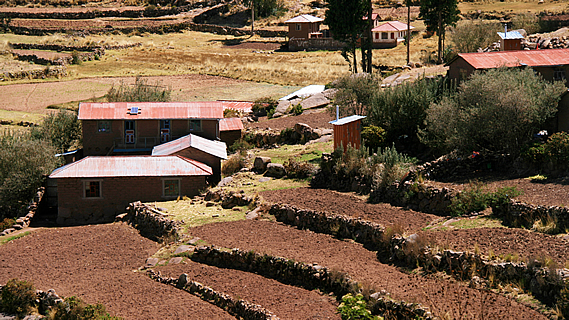
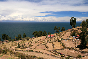
To our left were a few small farms with stone walls around them and matching houses. The land was steep, so it was terraced similar to the Incan terraces we had whilst hiking the Inca trail a few days ago. The soil seemed to be of poor quality here. To our right were more houses built from stone and clay in a built up residential area. Further up the hill we went over a sheltered gully that was full of small farms with plenty of houses. The stone walls and houses seemed to be natural parts of the landscape. Perhaps these had been built above the pre-Incan ruins of so long ago.
Storm approaching from Bolivia |
A little higher up the hill at about 3900 metres above sea level we passed through a small stone archway into a large open paved courtyard. From here we had a clear view out across the lake where I noticed a large storm was brewing. I hoped that it wasn’t heading this direction, but at such high altitude big changes in the weather can happen at an instant. I had not seen that storm from the boat, and I’m sure this wasn’t just because I had ascended a hundred metres.
Beside the low stone wall separating the courtyard from the dropping slope below stood a signpost with signs pointing to a lot of cities around the world. I had seen these before, but this one was badly weathered to the point you couldn’t read the most of the signs anymore.
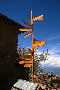
Weathered signpost |
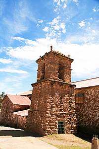
Tower in village square |
We explored the courtyard and noticed several other tourists also exploring the village. The two storey pink buildings that surrounded the courtyard seemed to be shops, but they were mostly derelict. I entered one and climbed up to the second level where the view across the island was amazing with the air incredibly clear. It is said that astronomers travel here from all around the world to get a clear view of the brilliant stars in the sky above. The island has almost no electricity, so there is very little light pollution to contend with when viewing the stars.
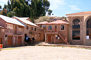
Village square |
At the island’s highest point about a hundred metres higher than the village stood the ruins of a pre-Incan settlement. Below the village were the terraces of the farms they had cultivated, many of these terraces were still here. The island has been divided into six suyus (or sectors) to use for crop rotation. Mainly potatoes are grown here forming the backbone of their economy. They also derive income from fishing and tourism. There are now 40,000 visitors to the island every year.
The local villagers wore traditional Spanish peasant clothing. This had been forced upon them during the inquisition five hundred years ago. They still wear the same peasant clothes now, but with the colourful Incan style clothing to make it distinctively Peruvian. They are very traditional compared to the mainlanders who mostly wear modern clothing. Despite their traditionalism, they have adopted the Catholic religion but they have adapted it to harmonise nicely with the Incan religion with Patcharmana, the Andean Mother Earth deity. They are known for making payments to Patcharmana and offer three coca leaves to her prior to starting any major activity or going on a trip. Unfortunately the coca doesn’t grow here on this arid island, so they have to buy it from Cusco.
Farms below the village |
The people here live very simple lives. Their mantra is based on the ancient Inca code “ama sua, ama llulla, ama qhilla (do not steal, do not lie, do not be lazy). As part of their traditional living they primarily speak the southern Quechua dialect.
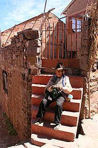
We turned off along a narrow stone cobbled lane and saw a ninety year old withered man with deeply wrinkled skin sitting on the stone stairs outside his tiny house at the corner of another lane. He wore a cream jacket and had brightly coloured knitted ear warmers under his cowboy hat. He was knitting. Carlos explained that only the men knit on this island. They start knitting at aged eight, and produce some of Peru’s highest quality crafts. They took great pride in their workmanship. This man had been knitting for eighty two years.
Old man knitting |
Rough path to top of island |
The villagers’ traditional views means electricity is almost non-existent on this island. Astronomers often come here for viewing the stars at night. At this altitude there is little atmosphere to look through on a clear night. Often in summer though, there is a lot of lightning about.
Serving warm coke at lunch |
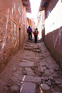
We continued up a narrow lane of broken cobblestones badly needing repair through a narrow walled alley until reaching a building that seemed to have been deserted for some time, like all the other buildings up here. To our surprise though there were people working in the building. We climbed a narrow flight of stairs to a flat stone roof where two tables were laid out for us.
We were exhausted from such a small climb, but we were 200 metres above the lake at 4000 metres above sea level. We had climbed to the top of a high mountain.
Our pretty tour leader |
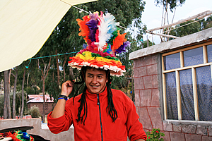
We were given a potato soup in naturally brown glazed bowls to start with as an appetiser. Carlos put on a long hair wig. Then he put on a ridiculously over decorated hat with bright colours and long feathers, but curiously it really suited him especially over his red polar fleece top.
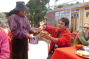
The main course was brought out, and I ordered some Inca Cola. The plate had two large fillets of fresh fish caught from the lake, chips, rice and mixed vegetables. They were served on a hand made ceramic brown fish shaped plate. One of the guys in the group had collected a serious stomach bug in the Amazon about a week ago. It was starting to play up again, and the chef recommended a warm coke. I had never imagined coke to be a cure for sore stomachs, but it seemed to work well. We were also given a coca herbal tea with the dried leaf in the hot water.
<< Previous | Next >> |
|
||
About this Page
|
||
|
|
|
Where is Walkabout Jeff? |
|
|

|
|
What is happening in Walkabout Jeff's hometown?
|
|
|

|
|
Who is Walkabout Jeff?Any normal person's idea of going out involves going to the local pub for a drink with a few mates. Walkabout Jeff isn't normal.
|
|
|

|
Follow Walkabout Jeff |
|