--- Archive files ---
Home > Travels > Tweed > 13 |
Springbrook Plateau
FROM the bottom of Tambourine Mountain I followed a rather long winding road climbing to the top of Springbrook Plateau. The road followed the Nerang River, the main watercourse running through Gold Coast City. The Hinze Dam blocked off the river at a depth of nearly a hundred metres. The road ran through the dry eucalypt forest over the rolling hills surrounding the pristine blue lake.
Track to Best of All Lookout |
Once at the end of the lake a side road steeply ascended a ridge heading up towards the plateau.
The relative dryness of this side of the mountain meant the forest was rather barren, but upon reaching the top of the plateau everything became a lot greener with much of the forest giving way to farmland. In the midst of the farmland was Springbrook Village. It was a lot smaller and less well known than the village atop Tamborine Mountain.
Forest near lookout |
I continued following the road after the village ascending the gentle slope of the plateau to a hill just short of the crater rim. A short walkway led from the hill to the “Best of All Lookout”.
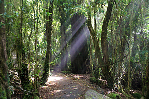
The concrete path entered the spectacularly beautiful rainforest. Thick cloud suddenly enveloped the forest, but only for a few moments before clearing again. The early morning sunshine filtered through the trees as small birds fluttered around in search of their early morning meal of insects.
View of crater from lookout |
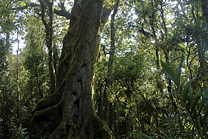
At the top of a small rise I reached a clump of Antarctic beech trees standing very spiritual in its ring around what would have once been the original host tree. Beyond that the trail started going gradually downhill before reaching the lookout.
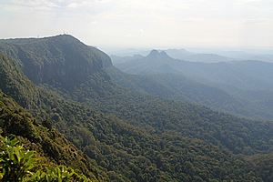
Despite a fair bit of morning cloud, the lookout did live up to its name. the view was spectacular. From the thousand metre high lookout the edge of the crater dropped very steeply into the Tweed Valley below with views across the rolling green fields to the jagged peak of Mount Warning. Beyond that I could see the mountains of the Nightcaps making up the other side of the crater.
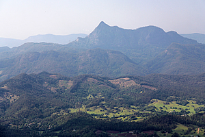
Mount Warning |
The mountains across the crater were nowhere near as pronounced as the ones on this side. I imagined it was because the other side was more exposed to the prevailing south easterly winds. Over twenty million years of erosion has taken a lot more of a toll on the other side of the volcano than this side. The other side had well and truly worn down.
Looking eastward I spotted the sea through a huge gap where the crater had disappeared entirely. The Springbrook Plateau is the nearest mountainous part of the volcano to the Gold Coast, so from here the mountains get lower before terminating at the sea. The two dominant peaks of Mount Cougall stood ominous watching over the grey ocean.
Track back from lookout |
Large wafts of milky mist rose along the steep sides of the crater, to meet the cloud already overhead.
Cloud suddenly enveloped the lookout, so I returned into the forest where rays of sunshine were filtering through the thin fog in the trees. It was short lived though, with the cloud clearing and the sun coming out again.
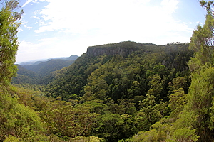
Upon reaching the start of the track I headed across Springbrook to the eastern edge of the plateau to Canyon Lookout. From here there was a spectacular view into the canyon through which several tracks passed in amongst the rainforest below. Here several streams accumulated together to create the east branch of the Little Nerang Creek.
Canyon Lookout |
I followed the track to the right, heading along the top of the cliffs over a large layer of hard basalt. The vegetation in this exposed area was open eucalypt forest with grass trees growing under them. I saw the occasional large black lizard suddenly slinking away. These were the same large species I had seen on the Dave’s Creek circuit. The track rose and fell with the top of the cliffs before descending at a stream above a double waterfall.
Track down the broken cliff |
From the bridge that crossed the stream, the track turned and followed a ridge heading eastward. At some point the track began to descend between massive boulders which had split off from the main ridge. The track erratically descended in between these huge cleaved rocks in a clever descent of the cliff.
Eventually the track reached the bottom of the broken cliff in dense rainforest. Shortly afterwards I reached a T junction where the track I had been following ended. The track going across the junction was part of the 18 kilometre Warrie Circuit which explored much of the valley I had earlier seen at the start of this walk.

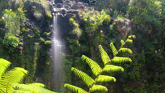
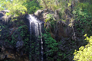
Rainbow Falls |
I turned right and began to follow this track, but not to do the entire circuit. After a couple of hundred metres I reached Rainbow Falls - a waterfall dropping from the cliff above and spraying out into a fine mist. Most of the cliff face was vertical apart from the soft rock at the bottom which had been naturally carved out into a deep grotto.
The track followed around the back of the grotto to provide dry passage to the other side where it continued along its circuit. I briefly rested at the back of the waterfall before returning to the junction where I continued following it around the bottom of the valley.
Twin Falls |
The forest was full of large rainforest trees which provided some shelter from the hot sun above. After negotiating around the end of a spur, the track headed towards the twin falls under the bridge I had crossed at the top of the cliff. Although quite dry, the falls were spectacular dropping into a large pool below. The bottom of the waterfall had an undercut big enough to provide full shelter from the falling water before turning northwards to follow the base of the cliff across to the other side of the valley.
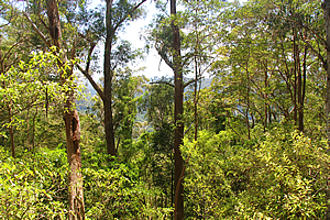
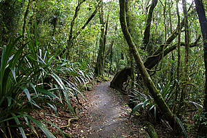
Dense forest |
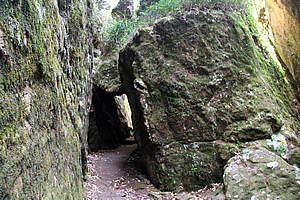
I passed some small caves that had been used by the Aboriginal people until around a hundred years ago. The indigenous people lived in caves in the rainforest throughout the volcano, but this was the first previously occupied cave I had seen on this trip.
The rainforest began to thin as I continued around the back of the valley before it suddenly intensified again as I reached a large stream where it plunged over Blackfellow Falls. “Black Fellow” is a common term Aboriginal people use to refer to themselves. People like me are called “White Fellows”. Perhaps this had been where the black fellas who lived in the caves further back along the track had gathered their water.
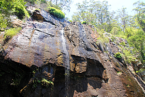
Blackfellow Falls |
The main track crossed under the face of Blackfellow Falls, but the Warrie Circuit passed here and headed downstream. I decided to take the downstream track to find a few more waterfalls.
The track moderately dropped zig-zagging down the steep slope out of view of the cascading stream. Eventually it did return to the stream at Poondahra Falls plunging out of the forest above into a clearing of small tree ferns growing amongst the grass.
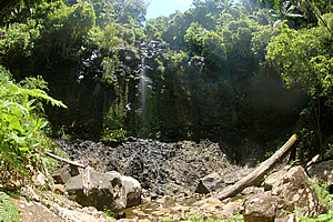
Poonyahra Falls |
From there I headed further downstream to Poonyahra Falls. It was getting too late in the day already to attempt the rest of the Warrie Circuit, so I returned uphill to Blackfellow Falls.
I saw more of those large black lizards scurrying away in the dense foliage, one of which I almost stepped on.
Upon returning to Blackfellow Falls I briefly stopped before following the track under the falls, with just a narrow gap of dryness under the overhang. Once passed, the track headed uphill around a short spur and gully before I was at the top of the cliff. The track crossed the stream just above the waterfall, giving fantastic views into the valley.
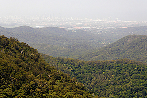
Gold Coast from Canyon Lookout |
The track ascended along the top of the cliff through tea tree scrub with the occasional lookout down into the valley. After another fifteen minutes I returned to the lookout from where I had started this circuit.
From here I returned down the road I had come, heading steeply downhill towards the Numinbah Valley.
<< Previous | Next >> |
|
||
About this Page
|
||
|
|
|
Where is Walkabout Jeff? |
|
|

|
|
What is happening in Walkabout Jeff's hometown?
|
|
|

|
|
Who is Walkabout Jeff?Any normal person's idea of going out involves going to the local pub for a drink with a few mates. Walkabout Jeff isn't normal.
|
|
|

|
Follow Walkabout Jeff |
|