--- Archive files ---
Home > Travels > Tweed > 14 |
Natural Bridge in the Numinbah Valley

MUCH of the exploring I had done so far had been along the tops of the plateaus of the shield volcano. I had done little exploration of the older deposits around the bottom of the crater. The deeply carved Numbinbah Valley presented this opportunity.
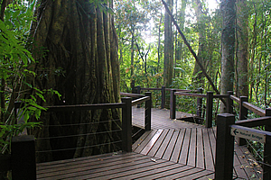
Boardwalk around the strangler fig |
A winding gorge above the unseen Nerang River followed the open eucalypt forest winding its way uphill until suddenly opening out into the Numinbah Valley. At first glance its U shape gave it the impression of being a hanging glacial valley with walls of rock towering hundreds of metres on either side. The mild climate here through would have made glaciation impossible, even during the most severe of the ice ages.
Instead there are thick layers of hard basalt on top of the plateau on either side – Springbrook to the left and Binna Burra to the right. The valley floor was another hard layer of basalt. In between these layers towered the near vertical cliffs of softer rhyolite. I had seen this layering elsewhere around the volcano, but nowhere had it been this pronounced where the steep valley walls stood six to seven hundred metres above the valley floor.
Descending towards the stream |
Much of the valley had been converted cleared into rich green pastures framed by the forested walls and plateaus on either side. Spectacular landforms such as Egg Rock towered out of the valley sides.
The road followed the valley towards a saddle at the crater rim. I was heading towards the Tweed Valley but there was one more stop to make before crossing the border.
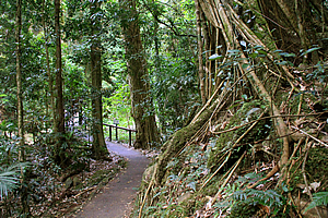
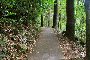
As the valley began to narrow into a forested gorge a rough sealed side road briefly headed up into a car park under the dense rainforest canopy. From there a circuit track of a very easy grade descended into a gorge.
Cave stream |
The paved track negotiated its way around large strangler fig trees towards the stream which I could now hear below in the forest. A huge pale worm lethargically slithered across the track.
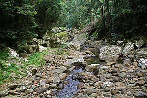
Eventually I did reach the stream, where a wooden bridge crossed over to a track following it upstream. Initially it seemed like any other valley with the stream gurgling its way between small boulders flowing with the gravity on its quest towards the ocean. The terrain suddenly steepened though and ahead the stream came out of a dark thundering cave.
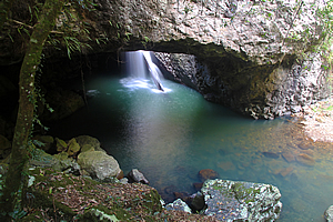
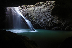
Looking under the natural bridge |
A small lookout provided an excellent view into the cave. I could just see a waterfall tumbling into the back of it, into a deep rippled pool that emerged at the gaping exit I was looking into.
I continued following the track with another side diversion heading into the cave. A large wooden staircase led the way to a viewing platform going most of the way into the cave over huge boulders covering the floor. These would have collapsed from the ceiling over many thousands of years as water seeped through and weakened the rock.
Waterfall in cave |
The waterfall plunged through a large hole in the roof. The pool was illuminated a strong blue from the light filtering through the hole through which the waterfall plunged. A large tree trunk blackened from waterlogging washed down from a past flood broke the waterfall. The water massaged its way down the remains of the branches.
The blue pool was rather localised. From there it passed through black water before being illuminated again at the mouth of the cave. This pool was turquoise coloured from the sun filtering through the forest canopy. The two distinctly different colours of the pools created a spectacular view within the dark cave.
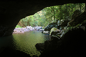
Cave exit |
The roar of the plunging waterfall was contained in the cave, making it sound a lot louder than it should perhaps be. The cave continued another twenty metres into the back where sometimes glow worms softly illuminate the cavern by night.
I left the cave following the track up the side of the hill to the ledge above the roof. The hard layer of basalt was a lot more resistant than the rhyolite that the cave has washed away.
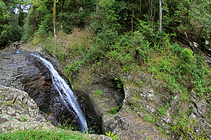
Waterfall plunging into the cave |
From the top of the cave, the stream cascaded over the pale rock before suddenly tumbling in a waterfall down a funnel into the dark cave below. The natural bridge rock continued for some distance before suddenly dropping off in a cliff beyond which the stream reappeared flowing through the forest.
The track followed the river upstream until crossing a bridge and heading back down the other side. A side track led to a viewing platform just above the waterfall where I had a better view downstream.
Track back heading out |
Once back at the junction, the track gradually ascended to the huge strangler fig that the board walk followed around closing the loop of the track. From here it was a short walk of moderate steepness back up to the car park.
Upon returning to the Numinbah Valley, rather than head back downstream, I headed up to the saddle, which wasn’t far away at all. The saddle was a very deep cut in the otherwise high and impenetrable crater. The Tweed Valley was still a long way below, so there will be quite a descent into it.
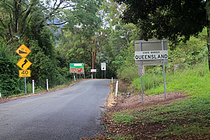
Qld/NSW border |
At the top of the saddle were a number of signs marking the border between Queensland and New South Wales. It was advertising all sorts of things like the $40,000 fine you get for bringing rabbits into Queensland. There was no signage mentioning what I thought would have been the most profound thing about the boundary – the change in time zone.
The southern states up to this point have daylight saving. Queensland doesn’t. This meant that by stepping over the border I was suddenly one hour ahead in time. This wasn’t too significant for me as the main time piece I was going by was the sun rising in the east in the morning and setting to the west in the evening. The change in timezones was purely academic with no practical application.
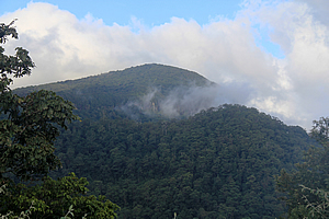
Springbrook from the saddle |
That being said one issue I have encountered with hiking in Springbrook and Lamington National Parks in recent days was with reading the time on my mobile phone. The time would suddenly skip an hour if it changed towers it was reading from, depending on what side of the border it came from. I would be hiking near the border when I would suddenly realise I had lost an hour somewhere in the excitement of the hike, only to realise later that it was only due to mobile phone towers playing tricks with me.
With crossing the border I was back in New South Wales, on the later timezone. With having explored the Numinbah Valley I was ready to head back into the Tweed Valley to explore the lower reaches of the river that drained the entire crater.
<< Previous | Next >> |
|
||
About this Page
|
||
|
|
|
Where is Walkabout Jeff? |
|
|

|
|
What is happening in Walkabout Jeff's hometown?
|
|
|

|
|
Who is Walkabout Jeff?Any normal person's idea of going out involves going to the local pub for a drink with a few mates. Walkabout Jeff isn't normal.
|
|
|

|
Follow Walkabout Jeff |
|