--- Archive files ---
Home > Travels > Tweed > 15 |
City on a Sandbar
THE TWEED River drains the entire crater on a north easterly heading towards the sea. The river has eroded the eastern side of the crater to the point where it no longer exists. Passing the centre of the crater at Mount Warning, tributaries meet up to create a substantial tidal river at Murwillumbah, the largest small town in the crater.
Mouth of the Tweed River |
From Murwillumbah the river meanders slowly towards the coast, passing by a final headland at Tweed Heads. The town continues over the hill across the border into Coolangatta, the southernmost end of the Gold Coast.
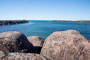
A boardwalk followed the crystal clear blue waters on its final approach to the sea. Artificial rock barriers directed the river out into the sea, creating a deep enough channel for boats to pass. The other side marks the start of a very long sand bar that separates the lower few kilometres of river from the open sea.
Mount Warning behind Tweed Heads |
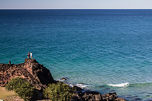
A walk along a path over the top of the boulders took me out to the crashing waves of the sea, the first I had seen the open sea since Cape Byron at the start of this journey of exploration of the volcano. I was now in the closing stages with the rest of the trip following the coast northward.
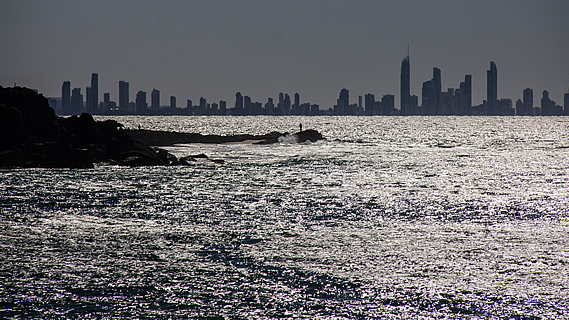
Looking across the small Duranbah Bay I could see the darkened silhouette of Point Danger with the towering high rises of the Gold Coast about 25 kilometres further behind. This was unlike any other view I had seen anywhere on this trip. It had mostly been thick rainforest in enclosed valleys.
Duranbah and Tweed River mouth |
I followed the path around the back of Duranbah Beach before heading up a stairway following the edge of the steep hill making up Point Danger. Like Cape Byron this was a hard remnant of the volcano, resisting erosion from the pounding blue waves of the ocean.
Eventually I reached the top of the headland where a large lighthouse tower rose high above. This was the Point Danger lighthouse, with an elaborate memorial to James Cook who sailed northwards along the coast in 1779. He called it Point Danger due to the array of reefs just beneath the surface of the water extending a good kilometre or two offshore. These reefs had all been created by the volcano. It was on this voyage negotiating his way past the reefs that he also named Mount Warning.
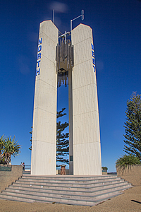
Point Danger Lighthouse |
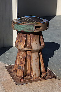
Map under lighthouse |
Although Cook had made it clear that this was a dangerous area to be avoided, it did make history when Queensland was split off from New South Wales. When Australia was first settled, “New South Wales” consisted of the eastern side of the country and “New Holland” the western side. The founding of the Brisbane penal colony a thousand kilometres up the coast from Sydney necessitated a new colony with its own boundary be split off from New South Wales. The new colony was called Queensland after Queen Victoria who signed this into effect.
Point Danger |
The Point Danger Lighthouse was built in 1971. Four rectangular pillars hold up the light 44.5 metres above the sea. Directly below the light was a bronze map of the area. A line passed underneath it extending out either direction on the lookout. Queensland was on one side and New South Wales was on the other, with a one hour time difference on either side.
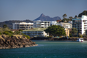
From the lighthouse I continued following the coast along a paved track running along the top of the cliff towards Coolangatta. This track marked the start of the Gold Coast Trail running the entire length of the coast. The track gradually descended past grassy picnic area to the left until reaching a stairway down to Rainbow Beach, a small bay nestled in a soft area of the lava flow.
Coolangatta |
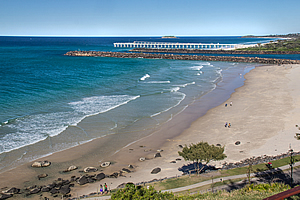
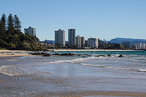
Once down on the beach I followed it around a point until in Coolangatta’s main bay, where the Gold Coast City stretched along a long arcing bay over the horizon. From here it was mostly sand beaches, but there were still a few remnant lava flows making its way all the way to the sea.
The final stage of this journey around the Tweed Volcano brought me into the heart of Gold Coast City, a strip of glittering high rises sitting precariously on a long sand bar at the edge of the ocean. The area was barren wetland forest until the village of Nerang was surveyed in 1865. The village of Elston was established on the coast some years later. It remained quiet and out of the way until Jim Cavill built Surfer’s Paradise Hotel in 1925. It proved so popular that in 1933 Elston’s name changed to Surfer’s Paradise.
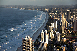
Gold Coast from Q1 Tower |
Over the years since the city has grown into a massive row of high rise apartment blocks towering high above the narrow sand bar between the Pacific Ocean and the enormous canal estate carving up the lower reaches of the Nerang River.
In stark contrast to the rest of the journey, the streets of Surfer’s Paradise were frenetic with activity. Countless people occupied the mall, some carrying surfboards to or from the beach. Others carrying selfie sticks were looking for opportunities to photograph themselves in the chaos of civilisation.
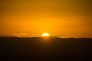
Sunset over Tambourine Mountain |
I escaped from the crowds of the street ascending to the observation deck of the tallest of these buildings, the Q1 standing at 322.5 metres high. The observation deck was on the 77th floor 274 metres above the street. From there I could see across the canals to the remains of the Tweed Volcano towering 4 times as high. From here it looked surprisingly flat being spread out over a huge area over 180 degrees from Coolangatta around to Tambourine Mountain. There were few clues of the massive cliffs I had encountered towering between the plateaus and the deep valleys below them.
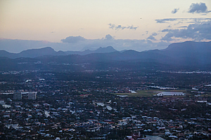
Dusk over the volcano |
The only obvious landforms I could see were the twin peaks of Mount Cougall, and of Mount Warning poking up behind them. To the left of these peaks stood the plateau of Springbrook, followed by a gap where I could just make out the Numinbah Valley before it rose again to create the sweeping plateau of Tambourine Mountain.
The sun dropped in the sky to set bright orange behind Tambourine Mountain. Once the sun had set the sky quickly darkened, washing away the volcano into its darkness. The only illumination left were the constellations of the bright lights of the city underneath the dim pinpoints of the stars overhead. The city came to life with its insidious nightlife along the frail coastal strip of the Pacific Ocean under the silently crumbling remains of the volcano.
<< Previous | Next >> |
|
||
About this Page
|
||
|
|
|
Where is Walkabout Jeff? |
|
|

|
|
What is happening in Walkabout Jeff's hometown?
|
|
|

|
|
Who is Walkabout Jeff?Any normal person's idea of going out involves going to the local pub for a drink with a few mates. Walkabout Jeff isn't normal.
|
|
|

|
Follow Walkabout Jeff |
|