--- Archive files ---
Home > Travels > Tweed > 12 |
Tambourine Mountain
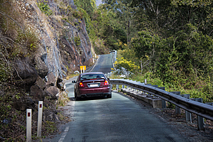
THE ROAD up Mount Tambourine from Canungra was rough and winding clearly showing the signs of little use. One section of the road was single lane with a traffic light at either end which switched every five minutes.
Narrow road up to Tambourine Mountain |
The dry eucalypt forests the road passed through were evident that this was a much drier area than the plateaus nearer to the crater. The Springbrook and Lamington plateaus absorbed most of the rain from the prevailing south easterlies.
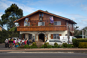
It was therefore a bit of a surprise to suddenly come out of the remoteness to encounter a significant town at the top of the plateau. The town started as a small farming community established by German settlers before it went to tourism. This was the first obviously touristy spot I had encountered since Nimbin (although the resort at O’Reilly’s would also be touristy for those who choose not to hike the trails. I had avoided the touristy bits at O’Reilly’s but here it was unavoidable).
Clock shop |
The first modern settlers here had been mostly German, so there was a strong European influence here. Most of the houses along the main street were of a very distinctive European style, the most magnificent of these being a timber chalet clock shop, where thousands of clocks of all shapes sizes covered the walls and aisles. Every single clock was intricately designed and had a large price tag to match. Every shop had its own distinctive style, with many European cafes and shops drawing me far away from the otherwise primordial quality infused into the volcano.
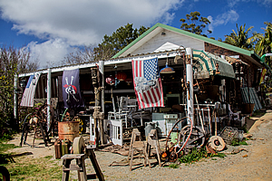
Antique shop |
Before the Europeans lived a tribe of Aboriginal People who called the mountain Jambreen – where the wild limes grew. Although very sour, the lime fruit were eaten with salt.
There are a couple of small national parks on the mountain, but these are all along the steep sides of the mountain. The top was almost entirely cleared for settlement, leaving only remnants of rainforest on its steep sides.
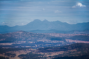
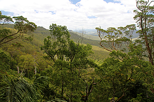
View to Mount Barney |
The first of these was the Witches Falls National Park. The very people who had cleared the top of the mountain for settlement promoted part of this side of the mountain to become Queensland’s first national park. Over the years since Curtis Falls and Palm Grove National Parks were also established across two other sides of the mountain. Now Queensland has over 250 national parks covering seven million hectares of land protecting two thirds of the ecosystems here. This area represents about four percent of Queensland.
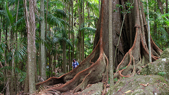
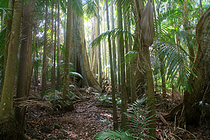
Forest in Witches Falls |
We found the entrance to Witches Falls National Park just beside the main road. Here the slope dropped steeply through bushland to the farming communities below where the Canungra Stream meandered on its journey towards the sea.
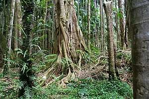
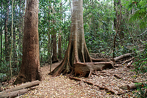
We climbed down the gently declining track into the forest eventually reaching a large rock shelf that was perhaps a couple of hundred metres wide. The ledge contained some spectacular forest. Some of the trees here were enormous, indicating no attempt at clearing. Although the ground was a little boggy underfoot the ground was reasonably dry. Signs indicated this was not always so with the forest floor often flooding into large pools following heavy rain. There were a couple of alternative tracks roughly cut into the forest for when the pools did flood, but today this wasn’t needed. The layer of thick basalt effectively created a hanging swamp giving nowhere for the water to drain out from.
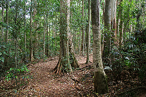
Forest in Witches Falls |
Eventually we reached a point where the ledge narrowed to just a few metres. We followed this until reaching a junction, then continued further for another five minutes before reaching the top of Witches Falls. There was only a tiny trickle flowing over the side of the array of huge hexagonal basalt columns. We couldn’t see the falls at all. What we could see though was the forest floor at the bottom of the falls was a long way below us.
The name “Witches Falls” was a bit of a curiosity to me. It was so named by one of the original settlers Hilda Curtis when she was eight years old on her daily trip to round up the cows after school.
Witches Falls |
Usually the cows remained on the plateau, but sometimes they wandered off into the forests covering the steep mountainsides. Often it was dark by the time she got them back. On a cloudy night in dense rainforest this would have been very scary. With no light to see by, she navigated by hanging onto the tail of the last cow, taking care not to slip in the steep slippery sides of the creek.
She recalled being raised on Grimm’s Fairy Tales – stories of witches, giants, goblins and other terrifying creatures. Her mother believed the forest was haunted, so she named the creek “Witches Falls” and the name has stuck ever since.
View from Witches Falls |
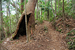
From the falls we returned along the track to the junction and followed the circuit sweeping its way uphill through the bush. The guy I was hiking with led the way, somehow missing an obvious bend and leading us in the wrong direction across soft soil. I knew he had gone off track and after a couple of minutes realised he didn’t have a clue that he was getting himself lost so I told him to come back. Fortunately my good navigation skills allowed us to quickly find the track again. From here on I decided to lead the way up the correct track now negotiating its way past a small cliff to the edge of the plateau. A scrub turkey was on the track at the top of the climb. We followed it along the top back to the car park.
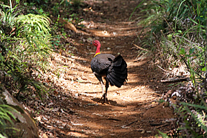
Brush turkey leading the way |
Heading across to the other side of the plateau, a track descended across another steep rainforest mountain slope. The Yugambeh people here tell of a story where the mountains were once flat. Gwayala and Burrajum travelled from Wollumbin with their two hunting dogs into the Logan area at what is now the foot of the mountain.
They encountered a hostile tribe and a battle took place. Unfortunately the hunting dogs were killed in the battle. The hunters carried them away before returning to perform a rain making ceremony in retaliation.
Forest in Palm Grove |
The spell worked with torrential rain falling for days on end causing the rivers to rise cutting deep into the flat mountain tearing away at the edges in great landslides. When the storm finally abated the plateaus and wide deep valleys between them remained. From certain points of the mountain the last resting place of the two great hunting dogs can still be seen. These are now the twin peaks of Mount Cougal in Springbrook.
The legend isn’t too far from the truth. After the volcano stopped erupting around twenty million years ago, the main geological force was that of water. Although the erosion didn’t occur during one massive deluge, the deep valleys have formed and widened eating away at the sides of the mountains have been eroded away from twenty million years of tempests. Large sections of the original dome remain, forming today’s land islands.
Forest in Palm Grove |
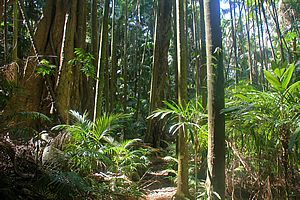
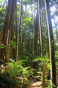
Although the top of the plateau has been well settled, the forest on the steep mountainsides includes over nine hundred species of plants over ten different native forest types.
The track eventually reached a large ledge substantially wider than that over at Witches Falls. This side of the mountain was exposed to the prevailing south easterly winds so it was a much wetter rainforest. The tall trees created a thick canopy overhead sheltering the abundance of piccabeen palms that grew here, hence the name of this area.
The track formed a figure of eight, so I crossed the central section for about ten minutes before reaching the junction of the larger loop, then doubled back along the low creek to the previous junction to walk the wider track.
Heading back I could just hear some gurgling sound from beneath me. The soggy ground seemed to be pretty stable. Later I would find out this was the sound of the giant Tamborine earthworm making its way through its sodden underground tunnels. I could see one of its spiralled piles of soil spheres on the ground nearby. These worms grow to over a metre long.
Forest in Palm Grove |
The track crossed the ledge until reaching the steep descent towards the bottom of the mountain. The track doubled back and followed the edge of the slope. The rainforest had suddenly given way to eucalypt forest. At the change there were large cycads growing. These date back to the age of the dinosaurs. There is a story that tells of a huge cycad that grew here dying in the 1930s that would have been 12,000 years old – having been germinated back during the last ice age. The track continued following eucalypt forest at the edge of the ravine until eventually crossing back over the ledge and back up the hill to civilisation.
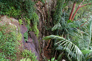
Forest near Curtis Falls |
Upon reaching the top we headed across to the northern side of the mountain to where the Curtis Stream flowed away from the village. A track dropped into a rainforest filled gully. Although the main road down the mountain to Brisbane was just metres away it seemed we were whisked a thousand miles away. The main trees here were the hoop pine, remnants of the giant forests that covered Gondwanaland 200 million years ago. These were the first trees to replace ferns as the dominant rainforest flora. Eventually these would be replaced with the flowering plants, but fortunately there are still a few substantial pockets of these plants left in the rainforests around the volcano.
Forest near Curtis Falls |
Once well in the forest we reached the stream. A side track led upstream for about a hundred metres to a small lookout over Curtis Falls. From there we headed downstream for about a kilometre to where the track crossed a bridge and headed back up the other side back to the village.
From the village we headed along the main road winding its way towards Brisbane. About a third of the way down the mountain a narrow side road headed to a small picnic area at Curtis Creek some distance downstream from the falls.
Start of Cedar Creek track |
A short well-formed track followed above a gorge where the stream trickled between large pools. Bellbirds chimed overhead in the otherwise silent forest. This would be a raging cascade after heavy rain, but today it was little more than a trickle.
This side of the mountain was largely sheltered from the prevailing winds, so the rainforest was quickly replaced with open eucalypt forest. Here dry trees grew in long grass, the perfect recipe for a firestorm. The trees have adapted to not only cope, but thrive in this destructive situation. Many seeds fall to remain dormant until burnt in a fire. The trees have evolved lignotubers at the base of their trunks to store substantial food reserves to regenerate following a firestorm. These forests largely replaced the rainforest as Australia gradually dried out. Here in Cedar Creek the dominant tree is the Queensland blue gum, where koalas lethargically live.
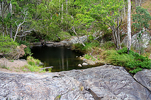
Pool on Cedar Creek |
The Aboriginal people once dwelt with the dipotodon, a giant marsupial that lived in these forests. They lived in herds carrying their enormous joeys as kangaroos do now. These were eventually hunted to extinction.
The deep gorge and rock pools of Cedar Creek were considered important to the Aboriginal people. The Wangerriburra people lived here and gathered their food, but was also considered a place to renew the spirit. Neighbouring groups joined them frequently for corroborres. As the Europeans settled the top of the mountain, the corobborees decreased in frequency to eventually stop completely. Towards the end some of the settlers were invited to join the corrobborees. One song first heard in 1872 was passed down through the Curtis family.
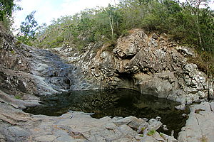
Pool on Cedar Creek |
We reached a large pool at the bottom of the gorge where the track ended. The steep sides of the gorge had hardly any vegetation on them. Perhaps it gets stripped away after big storms.
Following a short rest at the bottom of the gorge we returned to the road and continued heading northward down the mountain to the lowlands of the Albert River.
<< Previous | Next >> |
|
||
About this Page
|
||
|
|
|
Where is Walkabout Jeff? |
|
|

|
|
What is happening in Walkabout Jeff's hometown?
|
|
|

|
|
Who is Walkabout Jeff?Any normal person's idea of going out involves going to the local pub for a drink with a few mates. Walkabout Jeff isn't normal.
|
|
|

|
Follow Walkabout Jeff |
|