--- Archive files ---
Home > Treks > Inca Trail > Day 3 > 3.6 |
The Camp is just past the Bridge
WITH lunch finished we set of along the track. We walked about two hundred metres before pulling over to let our porters past so they could hurry to where we were going to be camping overnight. They had packed up very quickly, but will they be able to set up our camp before our arrival?
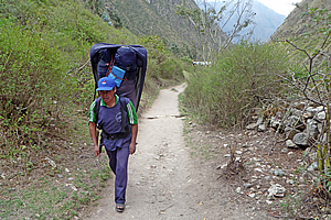
Porter |
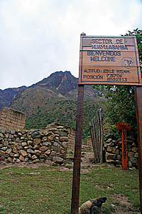
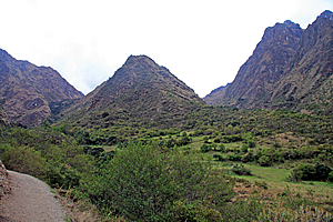
We continued following the valley passing an arid farm that separated the two halves of the village. Ten minutes passed before we reached the upper end of the village. There was a large natural terrace to our right at the base of a gully. On the terrace was a large campsite which Wilbur said most hikers stay the first night. He told us that we were going to go further today to give us a head start for tomorrow morning. We continued walking along the track past the campsite passing a sign that read “Sector De Huayllabamba, Bienvenidos welcome, Altitud 2912 M.S.N.M.”
The main campsite |
We crossed a bridge over a small stream. Another hummingbird was hovering through the scrubby trees concealing the stream which cascaded down large boulders. On the other side of the stream, the main track turned off to the right quite sharply. A much rougher track continued up the main river through the rest of the village towards more walking tracks into the Andean wilderness. These tracks included the rougher grade track continuing up the valley towards the base camp at the bottom of Salkantay, a major mountain in these parts which we hadn’t seen yet. The main track crossing this junction was the Mollepata Trail, which we will be following over the three passes towards Machu Picchu.
Just above the junction was a large circular rest area where we briefly rested. The rest area seemed to be the middle of the village perhaps where markets are regularly set up. The large common area was surrounded by two storey stucco brick rendered cream coloured buildings. One was a shop with a small opening in the wall where food could be bought, no doubt at very high prices. The large camping ground was only a hundred metres to our right so this shop would do very well. I knew our strategy of going up to the next campsite was a good move. It will allow us to better acclimatise to the high altitudes we will be scaling tomorrow, and will allow a shorter climb to the highest part of the track tomorrow morning.
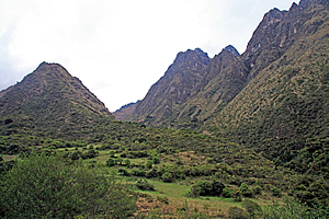
Entrance to the Llulluchapampa Valley |
We briefly stopped at the junction and one of the ladies Amanda somehow realised she had left her altitude sickness medication back at the hotel. She got into a panic while Wilbur phoned Luis who phoned the hotel to check on her room. Wilbur got a phone call back about five minutes later. Unfortunately Amanda’s hotel room had been cleaned and there was no sign of the medication. Lesson here was never leave anything behind in a hotel otherwise you will never see it again.
It was then I realised perhaps I should have got some altitude sickness medication. Well it was too late now for me to do anything about it.
The track proceeded steeply for a couple of minutes before we reached a checkpoint. Once more we had to stop as Wilbur checked our passes. The porters were in the final stages of getting their bags weighed again. Our tour company will get fined if any porter goes over twenty five kilogrammes. Fortunately this was not the case. It took a while for Wilbur to process us though, so we sat on a long bamboo park bench at the side of the track opposite the wooden inspection station and waited.
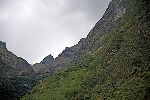
Dead Woman Pass in the distance |
From there we could see the top end of the valley we were starting to climb – the Llulluchapampa Valley. At the end of the valley was Dead Woman Pass. I looked carefully at the shape of the rocks, and it didn’t take much imagination at all for me to see the shape of a dead woman lying on her back, with her withered face and bust. The pass ran just under the bust, perhaps where the bottom of the sternum should go.
Long climb ahead... |
The pass was a long way up though. It was a little over four thousand two hundred metres above sea level and we were only at two thousand nine hundred metres above sea level. There was a thirteen hundred metre climb to the top from here, and it was all uphill. This was going to slow us down a bit, but I was thankful that we were not camping here for the night, otherwise that would be one very long climb tomorrow morning.
There was a large wooden map in front of us showing the trail, with about ten kilometres per day with a total of forty two kilometres to Machu Picchu from the start of the track. We had already travelled ten kilometres, but looking at the map those were the easy ten kilometres. From here on it was all going to be steep uphill or steep downhill across far more rugged terrain.
Finally we were processed and Wilbur let us go at our own pace towards the campsite. He told us to keep following the track uphill until we cross a wooden bridge. The camp is just a couple of minutes’ walk past the bridge to the right of the track.
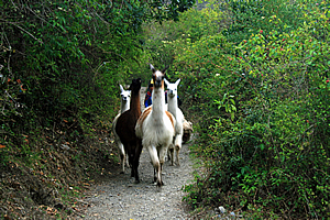
Alpacas on the trail |
We followed the rather steep track towards our campsite, slowly starting our ascent from the checkpoint at two thousand nine hundred metres. It quickly became apparent that I was in the fast group. I was moving up at a slow but steady pace, as one by one the laggards in the group disappeared behind us.
Suddenly ahead of us we saw some white alpacas barrelling towards us. I stepped to the bank of the track and watched them hurtle past, herded from behind by one of the local farmers.
Large sections of the track were now forested by small trees with gnarly branches covered in large bromeliads. The trees had orange coloured bark like layers of paper wrapped around them. These layers of bark were peeling off the trunks and hanging in strips. The trees reminded me of the New Zealand tree fuchsia only these were larger.
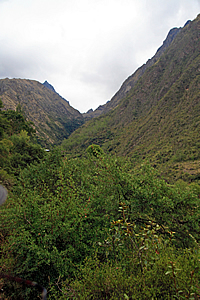
The upper valley |
The trees suddenly cleared as the track rose above a large terrace with scattered trees amongst the grass. No doubt the valley floor here was quite swampy. Ahead of us the valley divided into two glacial valleys. In between the two valleys stood a triangular scrub covered hill. The old glaciers that had come down these valleys had combined in front of the hill and terminated at about the point where I was standing. The pass was on the right hand side of the hill, but the track was obviously heading towards the left hand side. Then I remembered Wilbur talking about the bridge. We were heading towards the gully to the left, crossing the stream before heading around the base of the hill ahead of us to where the campsite will be. The area was quite open indicating there had been glaciers through here during some of the ice ages. The hills on the far side of the valley were now very steep, rising to a dark razor sharp ridge steeply rising to around four thousand seven hundred metres above sea level.
The gradient of the track reduced as we passed above the glacial valley floor. It was still a good steady climb though. Another ten minutes passed before I could see the wooden bridge ahead nestled in amongst the trees. The bridge was made from rather crooked logs of about ten centimetres diameter. There were crooked hand rails on either side nailed to a couple of gnarly trees growing on either side of the stream but like the bridge we had crossed just before lunch, it was perfectly stable. The people who maintain the track obviously didn’t have the same skills as the Inca of five hundred years ago, but they certainly were very skilled at building rustic wooden bridges.
The upper valley |
There were only four of us in our group now keeping the pace. Everyone else was trailing further behind obviously not having the same fitness levels that I had.
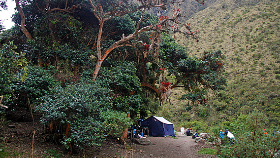
After a quick photo stop, we continued following the track. Fortunately the track here was level as we left the stream walking out to a small spur in between the two glacial valleys I had seen earlier. When we reached the spur, we saw the small track leading off to our campsite at Three Rocks just as Wilbur had said. We followed it for a few seconds before seeing the same large blue tent that had been pitched at lunch time down the bottom of the valley. Here it appeared rather small under a couple of large gnarly trees spectacularly covered in bright red bromeliads. The porters saw us arriving and stopped what they were doing to give us a standing ovation.
What a nice way to end a long day’s trekking.
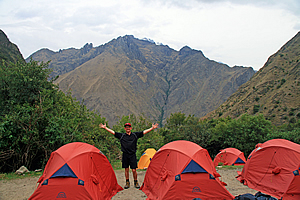
The campsite |
Our campsite stood on three small level terraces. The upper level where we arrived contained the two large blue tents under the large trees. Below that were two short narrow terraces where a number of small tents had been perfectly pitched. This was our accommodation for the night.
One of the porters took us to the pile of duffle bags where we had to work out which was ours. They were all the same navy blue colour. Finally we found our correct bags and the porter led us down to our tents. There were three tents pitched in the middle level and four in the lower level. Most of them were red for the couples, but two on the lower level were smaller yellow tents for us singles. I took the far single tent and settled in.
The tent was quite new and of a very high quality. It definitely would live up to anything the high altitudes would throw at it. There was a very nice warm yellow and blue sleeping bag set up inside. This was going to accommodate me very well.
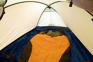
My tent |
Once unpacked I returned to the dining tent. By now the last of our group had just arrived to a standing ovation. We all settled in there for some hot chocolate and a very large aluminium platter of pop corn for a rather late afternoon tea as the sky quickly darkened.
Once we had finished afternoon tea, most of us went outside to do some stretching exercises. We were led by Kristen who worked for Jenny Craig back home on the Gold Coast. She obviously knew about exercise programs.
Following the stretching, I briefly returned to the tent to rummage around and find my head lamp. It had proven very useful up on Mount Kinabalu and in the Amazon, so now it was time to stretch it out for high altitude of the Andes. With little else to do and the temperature plummeting, I decided to return to the dining hut where everyone else was assembling. I needed to use the loo though, so I made my way about fifty metres down the hill towards a couple of long drops. There was another group camped out below us, but I don’t think they were as well set up as we were. They didn’t have a gourmet chef nor were their tents as good as ours.
I returned up the hill in the darkness guided by my head light. It was not long after afternoon tea but dinner was already almost ready to be served. Perhaps we had been a bit slow with the walk today. Then again we had walked quite a bit further than most people who would have camped out at the bottom of the valley. Who knows?
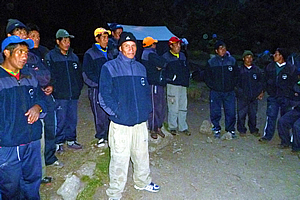
Meeting the porters |
Before going into the tent we formed a large circle with the porters, guides and cook and all introduced ourselves. The porters were all wearing their dark blue clothing – probably a uniform that was provided to them. The cook and porters all spoke Spanish – or perhaps some only spoke Quechuan. None of them spoke English. Fortunately Wilbur was fluent and Carlos spoke reasonable English, so they will be our interpreters for the trip. Wilbur did all the interpreting at this meeting.
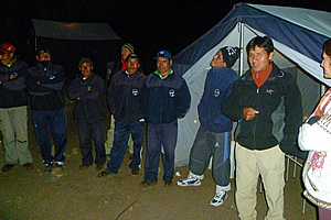
Meeting the porters |
Each of us travellers went around introducing ourselves, providing a brief explanation of who we were, where we were from, and why we have travelled so far to be here. For most of us it was the same spiel that we had given Luis back on the first day we had met way back in Lima. It was hard to believe that less than a week had passed since our initial meeting. Once we had introduced ourselves, the porters and cook introduced themselves, though their introductions were a lot briefer than ours. We remembered Ricardo the cook. His cooking had been fantastic so far and it turns out he was a gourmet chef. No wonder the food was so good.
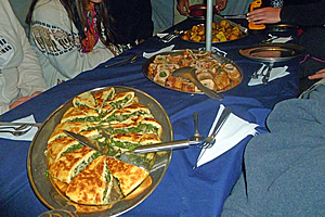
Dinner |
By now we were all very hungry. We entered the tent dinner. By now the cloud outside was thickening and it was getting very humid – a cold dank humidity that came with the cooling evening as a sure sign that rain was nor far away. The sky was already dark but a quietly roaring gas lamp hanging from the ceiling illuminated the tent whilst we ate.
The first course was a yellow vegetable soup. This was followed by the main course which was served in a banquet style. The table was quickly covered with large platters of rice, broccoli, quiche, roast potatoes and meat roll. Michael was given a separate meal to accommodate his weak stomach. Then we were given pudding in a small aluminium bowl. At initial glance it looked like a raw egg, but whatever it was it was definitely a lot tastier than a raw egg. It had plenty of sugar in it no doubt to help us in the high altitude.
Once dinner was finished, we returned to our tents walking through the darkness guided by our head torches. My tent had been very well set up with a good flat surface for the sleeping mat. The sleeping bag was very comfortable even though the air outside was quite cold here at 3300 metres above sea level. Gentle rain started to pitter patter on my tent helping me to quickly fall asleep.
<< Previous | Next >> |
|
||
About this Page
|
||
|
|
|
Where is Walkabout Jeff? |
|
|

|
|
What is happening in Walkabout Jeff's hometown?
|
|
|

|
|
Who is Walkabout Jeff?Any normal person's idea of going out involves going to the local pub for a drink with a few mates. Walkabout Jeff isn't normal.
|
|
|

|
Follow Walkabout Jeff |
|