--- Archive files ---
Home > Treks > Inca Trail > Day 4 > 4.2 |
Climb to the Top Camp
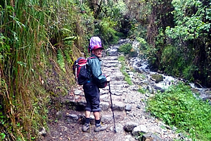
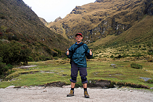
CARLOS led and Wilbur brought up the rear as we left our campsite. The track ran up thin forest, somewhat resembling the manuka forests of New Zealand or the paperbark wetland forests of Australia. What had been dirt track was now irregular cobblestone boulders perfectly assembled into a solid track. We were now away from the civilised area where the track had been worn out from centuries of use by farmers herding livestock. In this section of the trail the original track laid five hundred years ago was still intact, allowing us to follow in exactly the same footsteps of the Incan Emperor as he walked from the capital Cuzco to his retreat at Machu Picchu. The track ascended quite steeply alongside a cascading stream with ferny undergrowth.
Caption |
About half way up the steep section we had a quick rest whilst waiting for Wilbur to catch up with the slower members of the party. When they caught up Wilbur decided the overall pace was a little slow, so he left Carlos with Derek and Avani (a young couple from London) and Amy (the young Asian lady with the same model camera as me) at their pace whilst he led the rest of us at a slightly faster pace to ascend slow step after slow step with the air becoming increasingly thin with the altitude. At least the faster group will be able to maintain a constant pace.
Caption |
Fortunately it wasn’t raining even though it was still overcast. Soon we were out of the forest in a clearing, surrounded by scrubby plants with bright indigo coloured bell flowers. From here we could see the magical snow up ahead of us on the ragged ridges dusted like fine icing sugar. The ridges appeared a lot closer now. We could see the pass, but it still appeared quite distant. Looking back, we could see more of the mountains towering above us over the other side of the river now far below us. We kept going, and one by one the others started to drop back until only myself and Julia were keeping up with Wilbur. We were obviously the fittest ones in our group.
Caption |
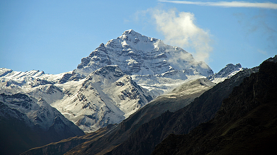
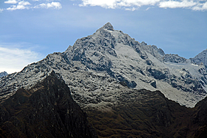
Looking back, we could see more of the mountains behind us, including more of Salkantay towering over 6300 metres high. The landscape behind us was getting more dramatic by the metre.
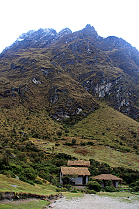
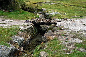
We followed the trail to about twenty metres above the steep gully, hearing the stream cascading unseen below us. Then we entered thick scrub again for a few minutes before reaching the Ayapata campground at 3750 metres above sea level. This was the highest camp on the trail, level with New Zealand’s highest mountain. There were still some campers packing up, and one of the villagers from the bottom of the valley had climbed all the way up here this morning and set up a stand selling brightly coloured soft drink. This would be the last shop we would see until tomorrow lunch time.
I walked out into the campsite. Across the stream stood a couple of small huts. They were just toilets and kitchen, but they were very cute buildings made from stone held together with mortar (a contemporary design) and with thatched roofing. To my surprise there was a medium sized white fluffy dog sitting alert in one of the one of the doorways. I crossed a tiny wooden bridge over the stream now crystal clear to reach a vantage point where I had a magnificent view of the Llulluchapampa Valley below me.
Caption |
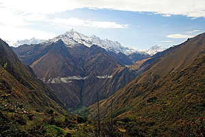
Small puddles of cloud hugged a few sections of the valley now eight hundred metres below me. I initially thought the clouds were stationary in the motionless air, but then I saw they were gradually rising up the gullies. The sharp ridges that had been high above us yesterday were now level with us. The village was just a few tiny dots far below us. Across the other side of the valley the snow-capped mountains towered much higher than where I was standing, most of them reaching heights of well over five kilometres above sea level. Salkantay was the highest mountain was to the right near the right hand ridge. At 6300 metres this was the highest mountain I had ever seen from standing on ground, although it was still around seven hundred metres short of Aconcagua which I had seen from the plane flying between Santiago and Lima.
Caption |
Unlike Aconcagua though, Salkantay had some beautiful glaciers and a fascinating rock form. The rock was folded in such a way that the summit was actually at the bottom of what had once been a valley, with the sides eroded away revealing an upward facing concave rock formation, even though the mountain itself was almost a perfect triangle. It reminded me of Mount Cook in New Zealand, which has a summit that is said to once have been at the bottom of a valley. At 3750 metres that is hard to believe until you realise the Southern Alps have actually been uplifted over ten kilometres high. The dramatic climate there has caused most of the mountains to erode away though. Here it was a bit different as I had noticed the Andes haven’t shown the same degree of erosion as evident in the Southern Alps. The uplift of the Andes is a lot more recent.
Caption |
I looked back the other way to the track rising steeply across the side of the valley towards the pass which was still a very long way away. The sheer scale of the place was accentuated with a few tiny dots of people inching their way up. There was nearly five hundred metres of climbing to go, and about two thirds of the way up I will be heading into record territory, above the 4095 metres above sea level I had climbed on Mount Kinabalu earlier this year. Everything past that will be new territory for me. I knew the final assault along the steep pathway was going to be tough.
I returned to the track. By now most people had arrived, apart from Amy, Derek and Avani. They were still further behind. I looked back across the gully towards the campsite toilets. The dog was gone but there we saw a family of alpaca, including one which had been born only a few days ago.
<< Previous | Next >> |
|
||
About this Page
|
||
|
|
|
Where is Walkabout Jeff? |
|
|

|
|
What is happening in Walkabout Jeff's hometown?
|
|
|

|
|
Who is Walkabout Jeff?Any normal person's idea of going out involves going to the local pub for a drink with a few mates. Walkabout Jeff isn't normal.
|
|
|

|
Follow Walkabout Jeff |
|