--- Archive files ---
Home > Treks > Inca Trail > Day 6 > 6.2 |
The Sungate
THE TRACK was rather crowded as we shuffled single file up the gentle uphill slope towards Machu Picchu. The sky lightened turning the clouds covering the jagged peaks from a soft purple blue to an angry yellow colour. The peaks themselves were still black. In between the peaks slithered purple glaciers tumbled down in suspended animation. The silver river snaked the bottom of the valley far below us.
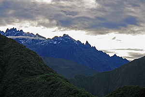
Jagged peaks |
We walked around the back of a steep gully onto Machu Picchu Mountain. The city was just on the other side of the mountain. Once more we entered thick cloud forest denying us our long distance view for a bit longer as the trail narrowed and went up and down against the precariously steep terrain. I was amazed that it could support forest. Small ferns grew in the cracks in between the rocks of the retaining wall to the left of the track. Tree ferns appeared in the forest, giving the area a starkly New Zealand look about it.
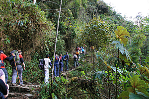
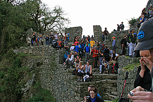
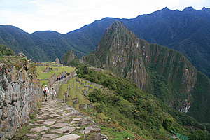
Crowd of pilgrims |
The track began a constant ascent rounding a point rewarding us with a spectacular view of the valley below. We were close to the edge of the forest, after which was cleared land as we had seen on the first day of the hike.
The track seemed to get more crowded as it steepened. Soon it was almost all steps as we shuffled along in a moving queue, climbing up in amongst a ruin in the thickening cloud forest. Then we were suddenly crossing over a pass in between the two pillars of Intipunku - the Sungate. We passed between the perfectly formed stonework to regroup with the rest of my group on a ledge to the left of the main gate. There we awaited the sun to rise.
Arriving at the Sungate |
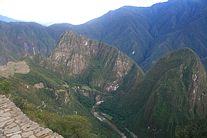
We were sitting on top of a flat rock wall about two metres above the track near the top of a precipitous rise, dropping almost vertically some seven hundred metres to the roaring river below. Well it would be roaring if we could hear it. It was too far away though. I could just see a long train snaking its way slowly along the bottom of the gorge, bringing tourists to our destination. The mountains on the other side of the river rose almost vertically to their domed forested summits. How any vegetation could cling onto them beat me.
At the Sungate |
Way up here on the mountain, we were almost at the edge of a large crag. Intipunku occupied a small col before the small hill that dropped off vertically in every other direction. Small trees and bromeliads clung on for dear life on this hill. The two pillars of the Sungate stood oblivious to the surrounding vertical terrain. For five hundred years these pillars have directed over a hundred and eighty thousand sunrises towards Machu Picchu. From here we were supposed to see the sun rise above the mountains beyond and send a ray of light from in between the pillars to the city of Machu Picchu about two kilometres to our left.
Machu Picchu from the Sungate |
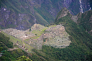
I could recognise Machu Picchu clearly, though I had never seen it from this angle before. The two thousand seven hundred metre high mountain of Waynapicchu (Young Mountain) had a much more gentle slope on the other side as it descended into the river. This side of the mountain, rising to about our altitude, was a vertical slab of rock forcing the river to pass around it. The city itself was clearly recognisable clinging onto the saddle at a surprising distance below us. This was the culmination of our journey, yet it was at the lowest point of the trail. We had started at two thousand six hundred metres above sea level, climbing to over four thousand two hundred metres before dropping to about two thousand seven hundred metres here. All we needed to do now was drop to two thousand three hundred and fifty metres at the city.
Machu Picchu from the Sungate |
The track followed the side of the mountain down to the city. This was our next leg of the journey. The city appeared quite strange from this angle. I had seen many photos taken from one location a lot further track, but not from up here. The mountains beyond the city seemed to be strangely flat along their ridges as they tapered away towards the Amazon.
Before heading down the hill though, everyone who had walked the trail this morning was sitting on their vantage points up here at the Sungate – a spiritually significant location. If it wasn’t overcast, we would have seen the sun rise and seen where the Sungate passed over the city. The overcast conditions prevented us from seeing it happen.
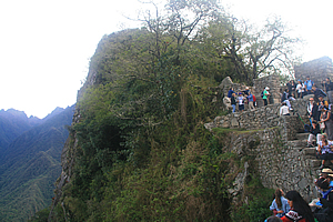
The Sungate perched on the precipice |
Looking back towards the city, I could see a road zig-zagging up numerous hairpin bends towards a car park and a building that was obviously the entrance to the city. Buses were starting to wind their way up the hill delivering the first tourists of the day.
Finally it was time to go. A lot of the other people left and started the walk whilst we took a very good vantage point for a group photo, loading up Wilbur with all our cameras – I got a very good shot of him holding all of them. We then left the Sungate and started the legendary decent to the city of Machu Picchu.
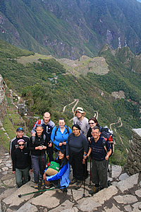
Group at the Sungate |
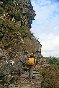
Trail to Machu Picchu |
The trail was quite wide, flanked with one perfect stone wall above and another one below the track holding it all in place. It was wide even where it passed one section around an almost vertical bluff.
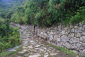
Trail to Machu Picchu |
The track itself was quite worn with soil over most of the stones. I guessed it was worn because many people would walk up to the Sungate from Machu Picchu.
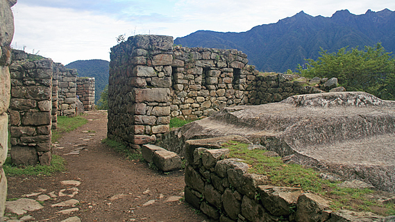
We walked down until we reached a small ruin about half way between the Sungate and Machu Picchu. The ruin was a single level containing what had been several stone buildings that seemed to have had flat roofing. That seemed rather unwise in such lush scrubby jungle. There were a few stone staircases leading up to more ruins in the scrub. Curiously none of the walls were plumb. Some blocks of walls were tapering out and others were tapering in.
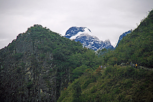
Looking back to the Sungate |
From here I had a spectacular view back up to the Sungate, with the jagged snowy peaks directly behind. I took some very interesting photos of it, including some of the people walking around the precipitous ridges. From here we could see the vertical strata of granite, indicating this entire area has been turned on its side during the uplifting of the Andes.
We continued walking down the track moderately downhill now nearly wide enough to drive along. We passed what seemed to be a quarry with a couple of buildings. Perhaps it was here that some of the rock to build the city was excavated.
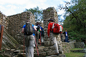
Entering Machu Picchu |
We continued until it eventually opened out into several stone walled terraces with low grass growing on them. This marked the top of the city. There were several llamas there all wearing brightly coloured red and green tassels. Now we were getting close to civilisation. I guessed this area had been used to grow the fine foods including corn that the Incan emperor had eaten whilst on retreat here.
Aside from the terraces, there was only one visible building. It was a small house with steep roof, but this one actually had thatching on the roof. It was hard to believe there would be an entire city below this house. We followed a rather deep furrow along one of the terraces to the far end. The terraces were unbroken apart from some steps ingeniously sticking out from the stone walls at exactly the right places to allow you to easily climb up.
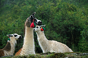
Alpacas at Machu Picchu |
We were near the end of the ledge when I looked over it, and saw the classic view of Machu Picchu, and the ledge from where people stood to get the classic photo taken. There were quite a lot of people already there as expected, but we had finally arrived at the legendary lost city of the Incas, built in the 1460s, having never been found during the Spanish inquisition. Having been lost and overgrown never to be visited for over four hundred years until it was finally discovered in 1914. This truly was a lost city rediscovered.
<< Previous | Next >> |
|
||
About this Page
|
||
|
|
|
Where is Walkabout Jeff? |
|
|

|
|
What is happening in Walkabout Jeff's hometown?
|
|
|

|
|
Who is Walkabout Jeff?Any normal person's idea of going out involves going to the local pub for a drink with a few mates. Walkabout Jeff isn't normal.
|
|
|

|
Follow Walkabout Jeff |
|