--- Archive files ---
Home > Treks > Kinabalu > Day 3 > 3.1 |
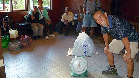
Weighing up at the bottom of the Mountain
IT WAS quite cold when I woke up in the morning. Everyone else was still asleep, so I quickly got dressed and quietly slipped outside into the crisp morning air. The sky was clear above me thank goodness. Last night’s heavy rain was already a distant memory.
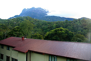
The mountain towering above the lodge |
Once off the leaning concrete stairs of the lodge entrance, I walked along the road to a clearing in the forest above the maroon red roof of our lodge. The mountain was standing tall in all its glory. I could see all the way to the top. From this angle it appeared very different to the view I had seen from Kiau yesterday. Over there the mountain appeared menacingly steep looming aloof to precipitous heights. From this angle it seemed a lot wider and a bit more walker friendly with a couple of moderately steep forested ridges rising towards the top.
The top of the mountain was fairly flat apart from some impossibly steep pinnacles looking quite out of place shrouded by wisps of cloud. A large patch of solid cloud stood behind the pinnacles giving them quite a spiritual feel about them, as if they really were the guardians of the spirits that went up the mountain. The cloud quickly enveloped the peaks as if to hide them from me. I didn’t need to know everything about reaching the top just yet. After all Sapinggi had told us we will conquer this mountain one step at a time. Pelan pelan. Slowly, slowly.
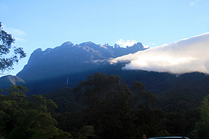
Mysterious mountain of craggy summits |
I returned to the bunkroom. The others were starting to get up, so I packed up ready to go. My daypack was ready containing my water bladder filled with water, plenty of warm clothes for the climb, and of course my cameras. The duffle bag Sapinggi had given me for the porters to carry was packed full of spare clothes, my camera battery charger and various adapters. Everything else went into the backpack to stay here at the bottom of the mountain.
Once everyone was ready, we took our daypacks and duffel bags to breakfast, reaching a small restaurant across the otherside of the car park from the information centre at the park entrance. The path to the restaurant had stone stairs and very pretty flowering landscaping on either side. The restaurant was open plan with high cathedral ceilings. It was a buffet breakfast and as usual the boys from Old Zealand ate a phenomenal amount of food especially given how skinny they were. Perhaps having a voracious appetite was a Danish trait.
Once breakfast was finished, we walked across to the park headquarters. The gear we were giving to the porters was weighed inside the left wing of the building, and we paid the per kilogram amount to the porters. Sapinggi was doing the weighing, and our other guides and porters were sitting around waiting to start the track, probably eying how novice we naïve tourists were.
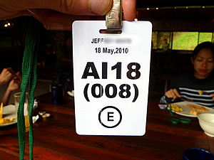
My pass |
Helping Sapinggi was our assistant guide Lianty, our porter Bambang and two other porters who I had not yet met.
Once our gear was weighed we went to a desk in the room to be issued with a plastic pass which we needed to wear on the mountain. It showed our details and the date. Without the pass we won’t be allowed onto the mountain, nor will we be allowed past certain checkpoints along the way to the summit. My pass said “AI18 (008) (E)”. I was member number eight of the party AI18. I assumed “E” meant that I was allowed up to the summit - that's if I survived the climb.
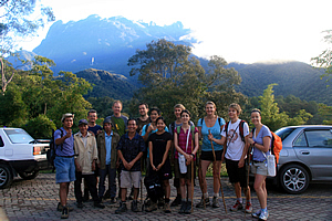
Our group ready to start the climb |
Now that we were all ready, Sapinggi lined us up outside on the car park with the mountain behind us. My camera was taken by one of the porters who photographed the entire group, ready to start the climb. Sapinggi and our other guides plus one of the porters stood in front of us. Being a full head shorter than the rest of us they had to go in front. It was a bit sad that these tiny men would be carrying all our heavy gear up the mountain whilst we would just have day packs. Anyway, they were getting paid to do it and they looked pretty happy about it. Hopefully they will be just as happy on the long climb up to Laban Rata. Anyway we were all keen and ready to go.
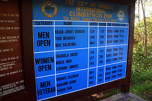
Brag board at the bottom |
A minibus took us to the start of the track, along a winding road heading uphill through the forest. Once at the car park, we stopped and got out. The early morning air was still crisp and fresh. We walked ten metres to the entrance at the Timpohon Gate at an altitude of 1866 metres above sea level.
Beside the gate stood a large sign showing the winners of the last year’s race. The times were amazing.
The winner from this year’s race had completed the run from here to the summit and back to the information centre in two hours forty minutes. Obviously we were going to take a lot longer – over twenty four hours at a more leisurely pace. If what Richard told me was true, then it was going to be a quite a slow trip up with some of us looking at all the remarkable plant life up here. I’m sure the people who had run the races earlier this year didn’t even notice the plants during their hustle.
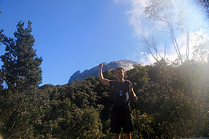
Reaching for the summit! |
We arrived at the entrance and climbed onto a viewing platform whilst Richard validated our passes at the ticket office below us. From here we posed in front of the mountain. The cloud that had earlier hung around the tops had almost completely cleared by now, but much of the mountain was obscured by forest on the next ridge. The forest looked remarkably like the native forests of New Zealand. We had a clear view of the summit area though. I raised my hand up and asked Jessica to photograph me with my finger touching the summit. She did a good job on that – though I’m not sure if we got the right peak. I think the summit was a bit further over the ridge out of sight.
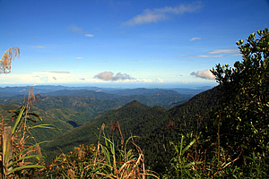
...although we are already very high |
From the lookout I could see down over the mountains we had driven up the other day. All the ridges were at about the same height at nearly the altitude we were. It certainly didn’t seem very mountainous at all down there anymore. We were not yet high enough to see Kota Kinabalu over the mountains. Looking back up at the summit, I saw a couple of small clouds passing over the next ridge briefly cutting out the view giving the summit a mysterious feel about it.
Once we had finished the customary "bottom of the mountain" Kodak moment photographing each other, it was time for the business end of things, so we walked through the gate, showing our passes, ready to start the long climb up the mountain.
<< Previous | Next >> |
|
||
About this Page
|
||
|
|
|
Where is Walkabout Jeff? |
|
|

|
|
What is happening in Walkabout Jeff's hometown?
|
|
|

|
|
Who is Walkabout Jeff?Any normal person's idea of going out involves going to the local pub for a drink with a few mates. Walkabout Jeff isn't normal.
|
|
|

|
Follow Walkabout Jeff |
|