--- Archive files ---
Home > Treks > Kinabalu > Day 3 > 3.2 |
Pelan Pelan
I HAD anticipated the climb of Kinabalu to immediately commence a very steep ascent up the precipitous terrain. To my surprise though the trail went quite steeply downhill from the end of the building at the park entrance. To me there is nothing worse than going downhill when you are supposed to be ascending to great heights.
The descent only lasted for a couple of minutes though as it entered the dense jungle. It was dark in the forest, but I could hear the distinctive hissing sound of a small waterfall nearby. We reached the dark waterfall and from there the track began to go uphill rounding a steep fern covered bluff up some stairs.
Lianty the assistant guide led our group, with Sapinggi took up the rear. "Pelan pelan, slowly, slowly", they kept saying. We needed to go up the hill very slowly to conserve energy and acclimatise to the altitude we will be encountering tomorrow in particular. We were heading into high altitudes today, so we needed to go slowly.
At the 0.5 km mark. |
The track was no longer steep at all once we were out of the gully past the waterfall. It was a good incline, but it was not long before we stopped to check out how everyone was going. I saw a small sign on the side of the track – KM 0.5, 1935 metres. Richard explained there was a marker like this every five hundred metres along the track all the way to the summit.
That was a brilliant idea. I’m the sort of person who sets ultimate goals, but likes to break it up into key milestones. I like to break the milestones into small tasks. Achieving each task works towards achieving a milestone. Achieving each milestone works towards the achievement of the ultimate goal.
Today goal for me was to climb higher than I had ever climbed before, to reach an altitude of over 3200 metres. This was far higher than the 2518 metres above sea level I have climbed to in the past. Tomorrow I will be climbing even higher to reach the summit at 4095 metres above sea level. The highest mountains I had seen before yesterday were Mount Cook in New Zealand, at 3754 metres, and from a plane I had seen the 3775 metre high Mount Fuji in the sunset when approaching Narita Airport in Tokyo a couple of years ago.
Climbing to 3200 metres today and to 4095 metres tomorrow morning seemed impossible by my standards, yet we were doing it now. That didn’t matter though. I just needed to reduce my goal to achieving each milestone of these small markers at the side of the track every 500 metres.
The distances didn’t matter that much. I really didn’t care too much how far away the summit was. Being a climb what was really important was how much altitude I was gaining. Fortunately these markers will say how high I am.
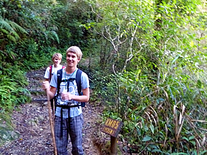
Pondok Kandis |
Walking to each marker was essentially the task at hand. Achieving the significant steps of exceeding 2518 metres at my record to date, the hut at 3200 metres, exceeding the heights of Mount Cook and Mount Fuji early tomorrow morning, reaching the summit, then getting back down to the hut were the key milestones. Arriving back at the bottom tomorrow having reached the summit was the ultimate goal. It’s one thing to climb to the top of a mountain, but the mountain is not conquered until you have come back down again.
We continued walking along the track, the slope uphill was moderate and comfortable. I commented this to Richard, but he said that it was going to get steep very shortly, and will continue to be steep the whole way up the mountain.
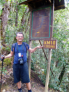
1.0 km, 2039m AMSL |
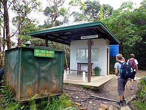
We arrived at the first stop, Pondok Kandis. It was a small white dining gazebo with a flat sloping roof and a single wall at the back, with simple poles at the front holding the roof up. In front of the hut was a large green cube drum about two metres high with the sign “Air tidak dirawat – Untreated Water”. Just past Pondok Kandis was another sign beside the track – KM1.0 (2039M).
This was only the fifth time I had been over two thousand metres above sea level – I had done two climbs of both Mount Taranaki (2518m) and Ngauruhoe (2289m) in the North Island of New Zealand. Otherwise I’ve always been below two thousand metres (I don’t count the times that I have been in an aeroplane though). I have always considered two thousand metres to qualify as the start of high altitude, even though high altitude doesn’t officially start until two thousand eight hundred metres. This sign had a large board with a map of the track above it. A small framed roof stood over the carved map protecting it.
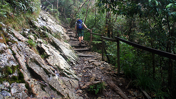
Sure enough, a couple of minutes passed before I saw the start of a long stairway leading up through the forest. The stairs were quite steep and irregular. By now the forest had changed from dark dense jungle into cloud forest with its characteristic moss covered tree trunks and branches.
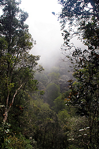
Cloud forest |
We climbed pelan-pelan slowly-slowly one step at a time. Fortunately there were some excellent railings to hang onto. They were constructed of very dark hardwood teak having been erected about thirty years ago. The railings were very crudely constructed though, with a pole sticking up from the ground and the railings haphazardly nailed into the sides of the tops, going off in whatever direction the contours of the path were going – mostly upwards.
So many people had pulled themselves up along the rails over the years that they had worn to perfect smoothness – almost polished. Over the thirty years since the railing had been erected, countless thousands of people had rubbed their hands on it to assist with their journeys up the mountain. That was a lot of people, a lot of journeys, and a lot of rubbing. No wonder the rails were so smooth.
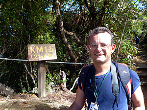
1.5 km, 2164m AMSL |
We loosely followed a ridge, passing a small signpost without a map board – KM1.5 (2164M). Here the ridge rose into a bluff we walked around it climbing the steep stairway. Otherwise we walked along the ridge following a fence with five cables fed through black PVC piping to protect them from the elements. By now our group was walking a steady pace. At this point the summit was too far away to even be thinking about it. Pelan pelan. There was no hurry at all, just conquer the mountain one step at a time.
<< Previous | Next >> |
|
||
About this Page
|
||
|
|
|
Where is Walkabout Jeff? |
|
|

|
|
What is happening in Walkabout Jeff's hometown?
|
|
|

|
|
Who is Walkabout Jeff?Any normal person's idea of going out involves going to the local pub for a drink with a few mates. Walkabout Jeff isn't normal.
|
|
|

|
Follow Walkabout Jeff |
|