--- Archive files ---
Home > Treks > Stewart > Day 1 > 1.1 |
Foveaux Strait in a Flying Combie Van
It was a grey overcast morning at Nelson Airport at the top of New Zealand's South Island. The sky was covered in a thick layer of altostratus cloud. It was still clear over in the east indicating this was the start of a north westerly marking the start of what will be a rainy spell over Tasman Bay over the next few days.
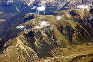
Southern Alps between Nelson and Christchurch |
From the tiny Nelson Airport I needed to fly down the length of the South Island and beyond. I caught a small plane flying across the Southern Alps down to Christchurch. The clouds were mostly clear going over the mountains providing some excellent views of the old glacial valleys and the bright snow tipped peaks of the mountains over two thousand metres high.
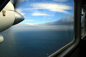
After about two hours’ stop at Christchurch airport I caught a slightly larger plane down to Invercargill, New Zealand’s southernmost city. The sky below was clear giving views of the tapestry of the Canterbury Plains. The perfectly patterned mosaic was only broken by braided grey and blue lines of the large rivers flowing out of the ancient glacial valleys of the mountains of the Southern Alps which towered over the western horizon.
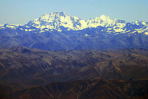
Mounts Cook and Tasman |
The mountains were getting higher and higher as I flew south, until the enormous hulk of Mount Cook appeared with its magnificent icy slopes. From there the mountains decreased in height and got further and further away. Then the view was blocked by a thin layer of low cloud below. Perhaps this was a mild southerly coming through.
Finally the plane descended into the cloud and landed on a sealed runway in the middle of bright green grass. The plane pulled up beside the tiny terminal building. I had arrived in Invercargill, New Zealand’s southernmost city.
The airport was serviced only by the occasional plane from Christchurch. Invercargill is a very small city with little need for incoming flights. There was nothing beyond here.
The first thing that greeted me upon leaving the plane was the icy cold Antarctic wind blowing from the south. It was a lot colder here than it had been in Nelson, or even Christchurch.
I had a two hour wait at the airport for my next flight across to Stewart Island. The airport was nothing special, but at least the terminal kept me out of the icy Antarctic winds that were blowing outside. Although this was meant to be the hottest part of summer, I was now so far south that summer hardly exists here. Any day that exceeds 20 degrees here is considered a heat wave.
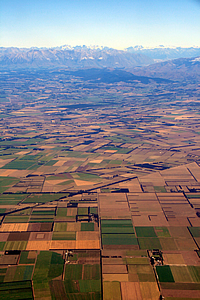
Canterbury Plains |
It was finally time for me to check in for my final flight of the day. I was thinking of those Hare Krishnas who had been celebrating in the centre of Invercargill that they had reached the farthest ends of the Earth. I had quite agreed with them as Invercargill really was the end. However there were settlements beyond Invercargill that perhaps should be considered to be beyond the end of the Earth. Oban on Stewart Island was the most remote of these, and that was where I was heading.
Foveaux Strait separates Stewart Island from the South Island. It is a wide and shallow stretch of water considered amongst the most treacherous in the world. There are only two ways to cross the notorious Foveaux Strait – by boat or by plane.
I had crossed by boat once before many years ago. That had been my first trip to Stewart Island. This was my second trip and this time I will be venturing further afield. As I had taken the boat last time, I decided to fly across this time around.
I checked in at the counter. Now normally when checking in for a flight I need to put my check in luggage on a set of scales to be weighed, to ensure it was not going to exceed baggage limits.
For the first time ever I was told to stand on the scales myself with all my baggage. They wanted to know the total weight of what was going onto the plane. As I weigh a lot more than my baggage that made sense to me. To me it made more sense to weigh the passengers as well as the luggage because I know passengers do come in a very wide variety of shapes and sizes.
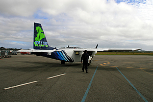
The Combie van with wings! |
There were a few other people checking in, and once we had all checked in the pilot (who had been the person checking us in) led us out of the airport into the blustery southerly wind to a small plane sitting on the tarmac.
This was unlike any other plane I had flown in before. It reminded me very much of a VW Combie van with wings, a tail and a propeller mounted on either side.
I climbed on board with the other passengers. The tinny doors really were like those of a combie van. I was getting worried they would fall off in flight. Obviously this plane wasn't designed for any significant altitudes. The cabin was very narrow with fold out seats that we had to crawl over to sit on. Once the first people were in the back seats the other seats would be folded back into place for others to sit in. It was very tightly confined.
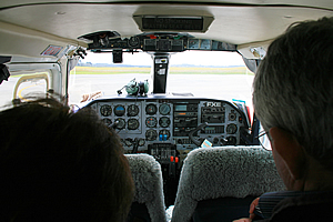
Inside the tiny plane |
There were two seats at the front for the pilots. However there was just one pilot. I crossed my fingers hoping he would be okay with flying the plane by himself. I always took comfort in having a pilot and a co-pilot in case one of them was to fall unconscious or something like that. With only one pilot at the controls in such a confined plane, if something were to happen to him, then there would be very serious trouble.
The pilot put on his earmuffs (well that was encouraging) and started the plane. The propellers in front beside the front windows spluttered to a start and he began to drive the plane along the taxiway towards the northern end of the runway. It felt a little strange having him sitting on the left hand seat. Obviously this was the side that pilots drive their planes on. Here in Australasia this was the passenger side of road vehicles.
Bottom of the South Island |
The cabin was rather dark inside with no lights. The plane had by now reached the end of the runway where it briefly hesitated before the pilot powered up the propeller causing the plane to shudder as it accelerated along the runway. This was the end I thought. Big planes are good as they are so smooth on runways, but tiny converted VW Combie vans like this were a whole different story rattling along the runway like this.
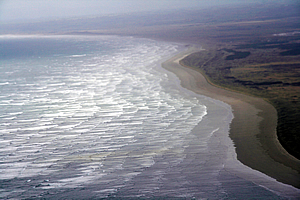
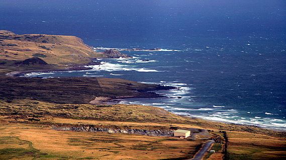
Beach near Invercargill |
Fortunately though the plane did take off and leave the runway. Once off the ground it swayed about in the turbulence of the southerly head wind.
The plane initially flew over the fields of Southland, with the main town of Invercargill nearby to the left. This quickly gave way to a large tidal inlet before reaching the sea. Large waves were breaking on the beaches on the coast, indicating a heavy Antarctic swell in the angry grey water. To the left were the port of bluff and the Tiwai Point Aluminium smelter. These were the last points of the South Island. From here on we were crossing one of the roughest bodies of water in the world.
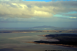
Stewart Island under mysterious cloud |
In the distance ahead I could see a few small islands in the salt haze. These were a couple of the islands immediately offshore of Stewart Island which I knew would already be nearby. It was a thankfully short crossing, and thankfully as we were flying it was going to be one very short trip.
I could see the island ahead. A layer of angry cloud covered the low mountains that made most of the northern side of the island an impenetrable barrier. The plane flew towards some lower hills on the eastern side of the island. Upon reaching the island it flew low over the forested hills before suddenly descending to land rather bumpily on a piece of sealed tarmac on top of a long hill in the middle of nowhere.
<< Previous | Next >> |
|
||
About this Page
|
||
|
|
|
Where is Walkabout Jeff? |
|
|

|
|
What is happening in Walkabout Jeff's hometown?
|
|
|

|
|
Who is Walkabout Jeff?Any normal person's idea of going out involves going to the local pub for a drink with a few mates. Walkabout Jeff isn't normal.
|
|
|

|
Follow Walkabout Jeff |
|