--- Archive files ---
Home > Treks > Stewart > Day 3 > 3.3 |
Exploring the Dunes
After unpacking and an obligatory cop of tea, we set off from the hut continuing along the track back towards Patterson Inlet.
Scrubby forest along the trail |
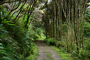
The scrub continued to thicken as we headed inland. The fern coverage over the ground thickened to the extent you would expect deep in a forest. The tree coverage was mostly manuka, with its slender trunks covered in grey papery bark rising four or five metres to fan out in a cluster of near vertical branches to their small bushy tops. The three or four metres between the think manuka canopy and the bright ferny foliage on the ground was occupied by the prison-like array of manuka trunks.
Tui |
The trail was well formed being wide enough to easily run a quad bike at high speed. The trail was almost level following a long gully through the plain of sand dunes.
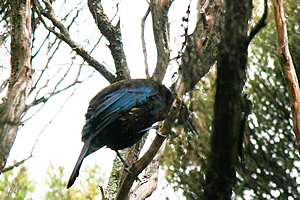
Looking up into the branches of the manuka canopy we could see a tui, a very dark metallic blue coloured bird with a white crest under its chin.
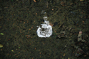
The trail began to wind as the dunes became closer. On the ground we found a small kiwi dropping – white runny excrement three or four centimetres in diameter.
Kiwi dropping |
A little further along the trail we found a putaputaweta in flower. This shrub has small mottled leaves and a tiny orchid like white flower.
Nearby was a pepper tree, the mottled pale green and purple leaves had a strong pepper taste to them.
It was not long before the manuka gave way to open grassland with scattered low scrubby bushes.
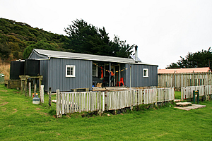
Ranger's hut |
Several minutes further along the path we found the first signs of civilisation. A farm had once been established here, but was eventually abandoned due to the harsh climate and poor swampy soil. Ahead of us was a wooden fence standing about three metres high. It had been constructed from manuka and tree fern logs. Although very old, the bark was still visible on the fence palings which had simply been cut lengthwise to size.
The fence enclosed an old barn no doubt built from timber milled on the island. Next to the large enclosure was a smaller one with a pale timber fence standing about one metre high. This surrounded a small hut made from galvanised iron and unpainted.
Ranger's hut |
Across the middle of the hut was a porch extending into its middle quarter. On either side was a white framed window appearing far too small to aesthetically fit the building. Two back water tanks stood to the left of the building.
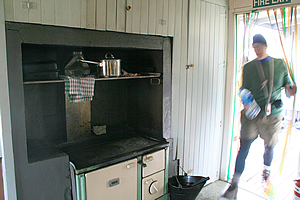
The inside of the hut had several rooms all painted an icy white colour. It was fully set up with a bath and kitchen and a couple of bedrooms. It was well furnished with nice wooden antique furniture that could have perhaps come from the original homestead here. The kitchen had a solid steel wood burner stove. It had a fireplace thankfully. Otherwise staying here during the winter months would be very miserable indeed.
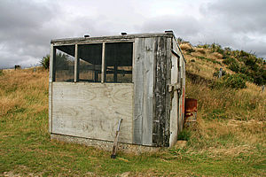
Chook house |
There were signs of habitation here with a quad bike and trailer parked outside. There was no one in though. Furhana let us into the hut obviously knowing the rangers who usually stayed here, but they were obviously out. Outside the house was a large chicken coop.
From the hut we left the track heading straight up the hill negotiating our way between large flax bushes and red tussock. The gullies were full of manuka.
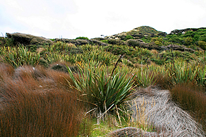
Flax and tussock growing in the dunes |
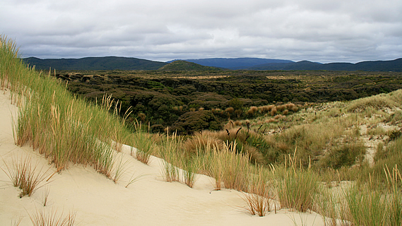
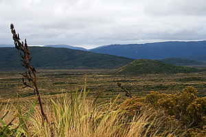
The rolling sand hills were covered in grass and scrub, but at their crests I could see the granite sand. In between the sand hills were large swampy areas covered in grass with the occasional flax bush. A couple of kilometres away was a forested range of hills creating a backdrop behind the dunes. No doubt the southern branch of Patterson Inlet was on the other side of the hills, or at least the long valley leading towards Doughboy Bay further south of here.
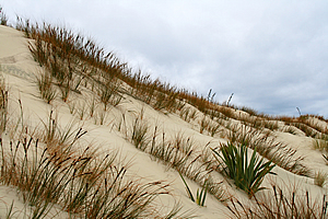
After some ten minutes of scrambling through the grass and tussock we came out onto the fine granite sand at the top of the hills. We followed the crests of the rugged sand dunes towards the beach. The dunes were held together by spinifex grass with very pretty yellow brown seed heads.
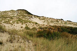
Dune |
We followed a sand blow gully steeply uphill towards the top of the highest sand dune. It wasn’t entirely a sand hill though. There were large flat outcrops of granite near the top indicating this was just a sand covered hill rather than a sand dune in its own right.
Upon reaching the rocky top of the hill we were rewarded with spectacular views of the sweeping Mason Bay in front of us. The rocky headlands on either side swept across the front of the bay but hardly offering any shelter from the big incoming Antarctic swell. To the right were a couple of islands, one fairly large and the other very small. They were both forested. I wondered if the larger one was a bird sanctuary.
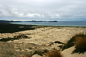
Mason Bay from the top of the dune |
Directly in front was a half kilometre wide patch of sand extending almost completely to the beach about two kilometres away. The sand blow continued to the left of the hill for another kilometre inland. There were just a few areas of spinifex grass holding the dunes together. To the right of the patch was the large area of manuka forest we had walked through. Part way into the patch I could see the hut almost invisible being the same colour as the canopy. Nearby was the scar through the forest marking the track we had earlier followed.
Looking inland from the dune |
From the top of the hill we walked down the start of the exposed sand blow towards the coast – though more correctly towards the hut. It was quite a steep climb downhill. The sand almost looked like snow being very white.
As we walked towards the bottom of the sand blow I was surprised to see a lot of pink granite stones. The sand must have been blown off here into the hills behind. From about half way down the hill a small stream flowed out of the sand creating braided patterns of heavy ironsand. This would have been the start of the stream we had followed between the beach and the hut.
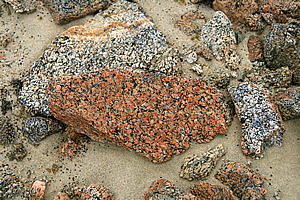
Granite at the bottom of the dune |
We followed the stream until it eventually entered the manuka forest. A small wooden bridge crossed the stream onto a short track to the grass clearing where the hut stood.
Upon reaching the hut it was still light, but with an early start tomorrow we needed to have dinner. Furhana collected all the pots and pans and plates we needed from a locked storage box at the back of the hut. It was very handy having this here saving the need to fly everything across with every trip.
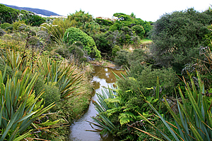
Stream near the hut |
We all prepared a stir fry heated with a gas burner. I was the stirrer quite conveniently. After about half an hour in the near darkness of the hut we sat down at one of the heavy timber tables and had dinner. The plates and cups were all cheap plastic, but the stir fry dinner and tea were very nice.
After washing up we put everything back away in the storage container at the back. We packed up ready for tomorrow’s early start.
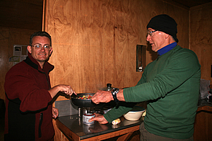
Cooking dinner |
It was still light outside so Furhana led us back on the track towards the beach. She said if we were lucky we will be able to see some kiwis. It will be dark by the time we return so there was a chance we would see them. She explained when it was dark we won’t be able to use our torches. Kiwis are scared away by light, but she did have a special red light that she would use to help us see them.
We slowly walked towards the beach but there was no sign of them. When we did eventually reach the beach there wasn’t much light at all. The sun had set unnoticed beyond the fading horizon. We stayed on the beach for a few minutes before starting our return to the hut.
Dunes near the beach |
It was quickly getting dark as we returned along the track. We took it slowly as Furhana tried finding any kiwi tracks. They were very elusive birds. Sadly we didn’t see any before entering the manuka forest.
By the time we reached the manuka forest the constant roar of the waves breaking on the beach had completely subsided. We listened out for kiwis calling. Furhana explained they usually call out a lot at this time of night. It was very quiet though. We only heard the occasional call. She said this was very rare - usually they are very noisy at this time of night.
We eventually returned to the hut in almost total darkness. The overcast sky wasn’t letting in any light from the moonless starry sky above. It was totally dark in the hut but somehow we managed to find our way to our own bunks. I crawled into my sleeping bag and very quickly fell asleep.
<< Previous | Next >> |
|
||
About this Page
|
||
|
|
|
Where is Walkabout Jeff? |
|
|

|
|
What is happening in Walkabout Jeff's hometown?
|
|
|

|
|
Who is Walkabout Jeff?Any normal person's idea of going out involves going to the local pub for a drink with a few mates. Walkabout Jeff isn't normal.
|
|
|

|
Follow Walkabout Jeff |
|