--- Archive files ---
Home > Treks > Stewart > Day 3 > 3.2 |
Flight to Mason Bay
It was about half an hour before the flight was due to arrive when Furhana my tour guide came and picked me up. We returned to near the wharf where we had travelled across to Ulva Island yesterday. She told us we will be returning here. From here we walked to her hut in the middle of town where I helped her pack up some supplies for this afternoon’s trip.
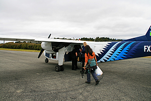
Once we had collected our supplies, we walked to the small building in town where the airport was based. I had been here upon my arrival, but hadn't entered the building. It was by far the smallest airport terminal I had ever seen, doubling as the island's post office. Furhana checked us in at the counter and a van quickly whisked us up the narrow road where I had travelled down the other day. Minutes later we reached the runway where the plane we were catching had already parked ready to go.
Catching the plane |
We were running a little late and she was hoping one of the nicer pilots would be flying today, but she leant over and whispered to me that we had the arrogant one. We climbed out of the van and carried the gear across to the plane. The pilot looked at her and muttered “You know the drill by now” referring to her lateness. It seemed this was perhaps a regular occurrence.
We squeezed into the back of the plane. There were already two men and a woman on board, all middle aged perhaps almost old enough to retire. The plane was rather cramped and the impatient pilot wasted no time in powering up the engines and taking off along the bumpy sealed runway in the forest.
The plane successfully took off and climbed to around a thousand metres, heading along the side of Patterson Inlet. It was very noisy in here especially following the past two days of solitude. This was as much noise as you got on Stewart Island so it seemed.
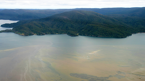
Top of inlet at Freshwater River |
Looking down at the water I could see large sand banks submerged beneath the surface. They looked like mud banks but the water was crystal clear. It was not until we reached towards the end of the inlet at the mouth of the Freshwater River that the water became cloudy. Throughout the entire journey thick pristine forest covered the hills right down to the water.
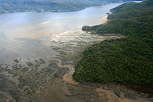
The tide was out, so there were many braided channels away from the main inlet. The plane crossed the strip of land running between the back of the inlet and a large sweeping beach of Mason Bay on the other side.
The plane began to descend as it swept over the violently turbulent sea around Mason Bay. The tide was out leaving the waves to break over the numerous submerged sand banks in a massive cesspool of turbulence.
The plane swung around the bay and lined itself up with the darker hard sand left from the water receding from the tide.
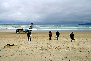
I had expected the landing on the sand to be very rough and bumpy, but it was smooth – even smoother than the landings on the sealed airstrip above Oban and at Invercargill Airport.
Landing on the beach at Mason Bay |
The plane came to a complete stop without incident thankfully. Upon slowing down it quickly turned towards the sea and came to a complete stop. We climbed out of the plane and collected our gear. Furhana lead us up along the wide granite beach towards the tussock covered dunes beyond. Looking either side of the bay the steely green low headlands jutted out into the turbulent sea.
The sand was patterned from where the strong wind had blown it along eroding the dry patches in between the areas that were still wet from recent rainfall.
Behind us the plane took off precariously along the sand, ascending over the bay, then eventually disappearing. The roaring hum of its engines faded away enveloped by the constant whitenoise of the breaking waves.
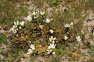
Flowers in the dunes |
Otherwise it was very quiet here. We all introduced ourselves. The other three in the group were all together. There was John and Mavis, a couple from Invercargill, and his brother Dicken who was visiting from Scotland. Dicken had recently retired. John worked as an anaesthetist in Invercargill.
We reached the start of a single lane road sized trail leading through the sand dunes, following a small stream. The trail initially wound around the sand hills following the small stream upstream until the tussock quickly turned to scrubby manuka that covered our heads over the trail. The ground was covered in a thick matting of green ferns. We followed this for a good five or ten minutes before reaching the Mason Bay Hut.
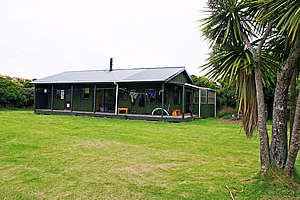
Mason Bay Hut |
The hut was in a spacious grassy clearing which would no doubt support tents during busy periods. The hut had an unpainted corrugated iron roof. It was a small hut painted a dark gloomy green colour. It had a veranda out the front and a small lean to on the right hand side for a ranger to stay. A trail led to the toilets in the bush, but otherwise the hut was fully self-contained with a sizable kitchen and dining area with solid timber furniture and a separate bunk room. Here we unpacked and found ourselves a bunk for tonight.
<< Previous | Next >> |
|
||
About this Page
|
||
|
|
|
Where is Walkabout Jeff? |
|
|

|
|
What is happening in Walkabout Jeff's hometown?
|
|
|

|
|
Who is Walkabout Jeff?Any normal person's idea of going out involves going to the local pub for a drink with a few mates. Walkabout Jeff isn't normal.
|
|
|

|
Follow Walkabout Jeff |
|