|
||||||||||||||||||
|
||||||||||||||||||
Home > Diaries > 2018 > 739 |
||||||||||||||||||
|
||||||||||||||||||
|
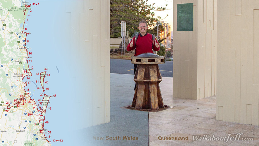
THREE years ago I started hiking the South East Queensland Coast starting from the Tewantin Information Centre, with the intention of completing short sections over free weekends eventually reaching the Gold Coast. I can finally say that this has been achieved, with the recent extension up to Rainbow Beach, the new "official" starting point, I have hiked all along the coast (plus going up and down the Brisbane River and hiking around ten islands) down to Point Danger at the bottom of the Gold Coast. Today I hiked the last two sections of the route, starting with a sunrise at Surfer's Paradise and walking down to Burleigh Head during the morning. I then completed the very last section this afternoon starting from Currumbin. I ending up here at the Captain Cook Memorial at Point Danger on the Queensland/New South Wales Coast at sunset - right on schedule. Now to sort through the 32,707 photos I have taken over the 1041 kilometre hike (that averages one shot every 32 metres!) for and compile into a 52 day sequence, each day representing one of the weeks of the year. Fortunately I'm well through the editing, so will be starting to publish this epic journey in the very near future. |
||||||||||||||||||
|
||||||||||||||||||