|
||||||||||||||||||
|
||||||||||||||||||
Home > Diaries > 2023 > 1042 |
||||||||||||||||||
|
||||||||||||||||||
|
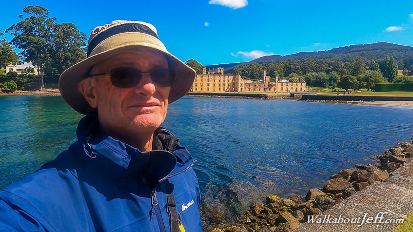
I HEADED back to the Hobart waterfront in the early morning to join a tour group and travel by bus south westward towards Port Arthur. Patches of low cloud caught the early morning sunlight in the otherwise clear sky as we crossed the Tasman Bridge and a couple of causeways to follow the hills between the harbour mouth of the Derwent River and the Tasman Sea. After a morning tea stop, we continued to Pirates Bay where we headed to a jetty to climb on board a large jet boat. We were instructed that those prone to seasickness should take the back seats as the front seats will be very bumpy. I sat near the front. The boat sped off heading around Fossil Island into the very choppy head swell coming off the exposed Tasman Sea. Once around the island, we turned south heading past spectacular layered cliffs making the occasional stop to view the very interesting formations. The view from here was amazing looking up the towering cliffs. Speeding along almost surfing the swell, we made quick progress along the rugged coastline making stops at different formations including caves, ravines and overhands and passing inside the occasional rocky islet towering out of the pristine water. The cliffs moderated as we crossed a bay towards the jagged headland on the other side. We stopped at the rugged headlands, including a couple of small islands cut off from the mainland with very narrow channels in between them. In one of the channels towered The Candlestick, a vertical column of rock rising about eighty metres from a base less than twenty metres at its widest point. This is considered to be Australia's most difficult rock climb for those who are crazy enough to attempt it. Rounding the headland on a very rough swell, we explored the other side of The Candlestick and other islands before contining across the bay suddenly encountering a brief rain squall which was fortunately short lived and clear by the time we were across the next bay towards Cape Pillar, heading between the cape and the nearby towering Cathedral Rock. Once around the cape, Tasmania's highest sea cliffs appeared, towering 250 metres out of the sea. A short distance offshore was the small Tasman Island, towering to 230 metres. We headed towards Tasman Island, stopping offshore from a hut on a structure overhanging the rocks where numerous fur seals were relaxing, and some swimming in the water amongst the giant kelp. We headed towards the end of Tasman Island, Australia's closest point to New Zealand, being just 1485 kilometres from Resolution Island at the entrance to Dusky Sound. This point also marked the southern end of the Tasman Sea and the start of the Southern Ocean. From Tasman Island, we started heading back, stopping for a while to watch dolphins and albatross before speeding back towards Pirates Bay. Following the top of the cliffs and ridges above them was the famous Three Capes Track, which would give interesting views of this spectacular area from another angle. The return journey was a lot smoother due to being quite a bit offshore away from the cliffs from where the swells were bouncing off. Eventually we turned back into Pirates Bay and climbed back on the bus before heading across the hills and around the coast to Port Arthur. Here we stopped for lunch before exploring the historical site. Heading towards the Port Arthur Jetty, I spotted the ruins of the Broad Arrow Cafe, now abandoned and turned into a memorial of the 1996 massacre when 35 people were killed here. From here I headed down to the jetty where ships arrived in the early days of the colony from England. These days it is used by pleasure craft sailing the pristine clear waters of the bay. From the jetty I headed towards the remains of a large stone building, originally built as a flour mill in 1845 but eventually became the main penitentiary. The roof was missing and parts of the walls were crumbling, but the building was well supported by steel framework. I spent quite a bit of time exploring the old building. From the main building, I explored numerous small houses and other buildings further up the hill, all in their original state when the convict colony was running. Heading further around, I passed a few old factory buildings, a town hall, and a courthouse and jail cells. Crossing a large field, I reached the village of the governor and prison officers, all with nice gardens. Heading above these houses I reached the remains of an old stone cathedral with its roof missing. Below this was the government house and gardens, all very nicely manicured. Having completed the circuit in several hours, I finally reached the modern building where I had started and had lunch. From there we climbed back on the bus and headed back to Hobart. |
||||||||||||||||||
|
||||||||||||||||||