|
||||||||||||||||||||||||||||||||||||||||||||||||||||||||||||||||||||||||||||||||||||||||||||||||||||||||||||||||||||||||||||||||||||||||||||||||||||||||||||
|
||||||||||||||||||||||||||||||||||||||||||||||||||||||||||||||||||||||||||||||||||||||||||||||||||||||||||||||||||||||||||||||||||||||||||||||||||||||||||||
Home > Treks > Australia > Mount Kosciuszko > 2 |
||||||||||||||||||||||||||||||||||||||||||||||||||||||||||||||||||||||||||||||||||||||||||||||||||||||||||||||||||||||||||||||||||||||||||||||||||||||||||||
|
||||||||||||||||||||||||||||||||||||||||||||||||||||||||||||||||||||||||||||||||||||||||||||||||||||||||||||||||||||||||||||||||||||||||||||||||||||||||||||
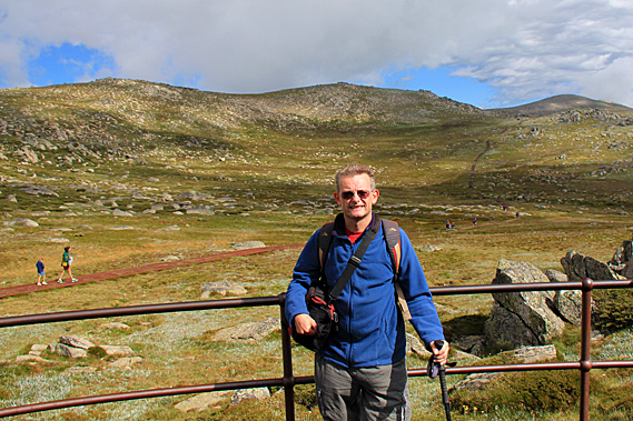
Introduction to today's journeyThe particular configuration of this eminence, struck me so forcibly by the similarity it bears to a tumulus elevated in Krakow over the tomb of the patriot Kosciuszko, that although in a foreign country, on foreign ground, but amongst a free people. Who appreciate freedom and its votaries; I could not refrain from giving it the name of Mount Kosciuszko. - Paul Strzelecki. Today's trek starts at the Threadbo Resort where we catch a chairlift up the mountain and hike across the tops to the summit of Mount Kosciuszko and explore the subalpine highlands. Today's JourneyDistance trekked today: 17.2 kilometres. Total distance trekked to date: 19.7 kilometres. A NERVOUS anticipation always fills me on the day I climb to the summit of a mountain. There are always so many unknowns in such hostile changeable places. Anything could happen during an ascent, and of course there’s no guarantee of reaching the top.
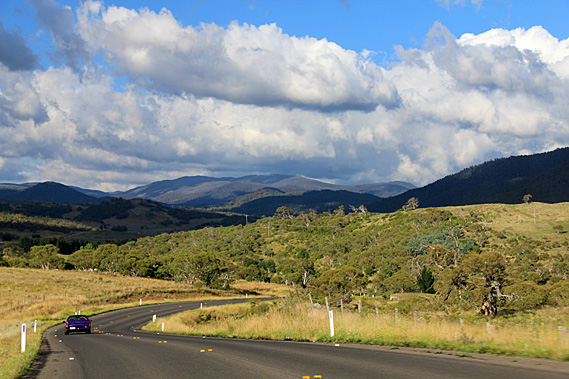
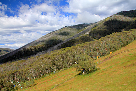
Rain had fallen overnight, but it was had cleared by the early morning. The sky dawned still mostly covered in cloud at around 2000 metres. We set off from our base at Jindabyne following the road up through the Threadbo Valley. The valley very much reminded me of New Zealand with its rounded mountains towering over the glacial valley carved out in ice ages past. The road markings were all orange. During winter snow falls to low levels. The white markings you would normally see on a road turn almost invisible against the snow. Yellow is easier to see. As we continued following the valley upstream, the farmland gave way to snow gum forest rising from the valley floor up the mountains on either side. Large areas of these trees were dead though. Perhaps this was due to a disease affecting the forests. The forest gradually thinned with increasing altitude to alpine grassland at the very top of the ridge. At one point we stopped at a toll booth to pay a park use fee. The lady at the counter said conditions will be pretty good on the mountain today.
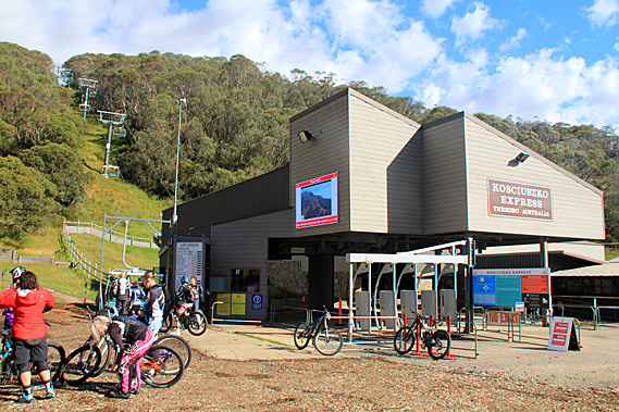
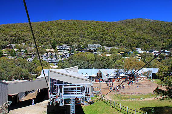
Soon the stark subalpine gorge with its pristine montane forest gave way to a collection of resorts making up Threadbo Village. Construction of the village began in 1957 after the road was completed as part of the Snowy Mountain Hydro-electric scheme. Upon reaching Threadbo we headed across a bridge over the river to the chairlift. There was quite a queue there of like-minded people wanting to climb Australia’s highest mountain. A sign at the front of the building said the temperature at the top of the chairlift was 3 degrees with wind speed of 41 kilometres per hour. I looked at the people in the queue. Most people there seemed to be reasonably well prepared. I was thankful that I was wearing my polar fleece top. I’ll definitely need that up the mountain. Not everyone else was as prepared though. Some Chinese ladies standing in front of me were wearing sandals. They won’t get very far up there in the alpine terrain.
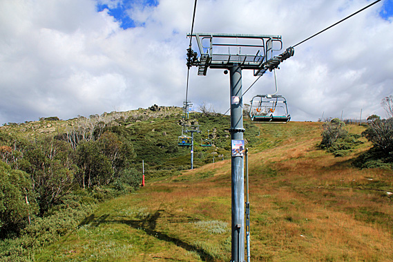
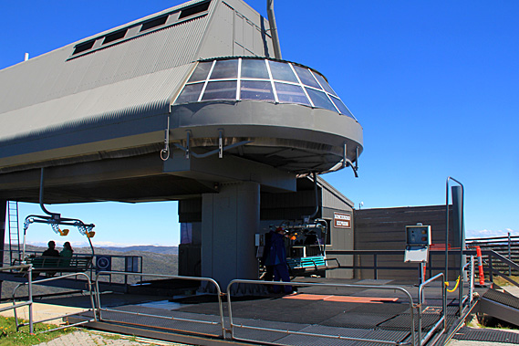
Finally with tickets bought we headed over to the chairlift. Now we are both scared of heights and neither of us had been on a chairlift before. We were both tense in anticipation and at the last moment he decided to go to a café to get his morning coffee fix. When that was over we headed up the stairs to the start of the Kosciuszko Express chairlift. There were a couple of groups of cyclists being briefed by their leaders. Apparently they will be riding the chairlift up the mountain before cycling back down along the ski routes. We climbed into one of the chairs. At the time we didn’t know there was a bar that we are supposed to pull down over our heads so we rode up it precariously perched on the seat hanging onto the rail behind our heads.
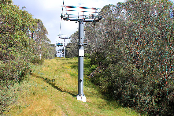
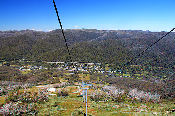
The chairlift initially started a steep incline before levelling out. The chairlift followed a row of metal structures along a twelve metre wide grassy clearing through the forest. Threadbo Village quickly dropped behind us. From the top of the incline I could see the enormous rise we had yet to cover. From bottom to top there was an altitude gain of 560 metres over the 1800 metre journey. The grade was fairly gentle at the bottom but it gradually steepened towards a rocky bluff at the top where I could see the other end of the chairlift.
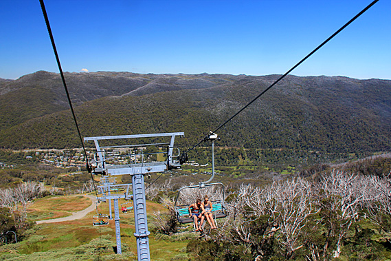
The clearing widened. I could see the ski runs below me. There wasn’t any snow at this time of year so they had been converted into cycling tracks. On either side of the clearing was thick forest of snow gums. The trees immediately on either side were healthy, but there were large patches of dead forest, particularly along the main ridges. The slope we were climbing was getting steeper and at times we were over fifteen metres above the ground. It was an awful long way to fall down. It ascended to the top of a gentle spur where the slope lessened a little before the final steep climb to the top.
The grassy ski run suddenly gave way to large rocky outcrops towering out of thick subalpine scrub. The trees on either side were very gnarly and the forest was quickly thinning as we approached the treeline, where it was too cold for them to grow. One outcrop we passed jutted out about ten metres at 45 degrees. There was just a hundred metres to go to the building at the top. It was perched on top of a 15 metre high granite cliff face. The wind suddenly picked up causing out little carriage to swing from side to side with each gust. It was rather terrifying going up over the top of the cliff, but at the top the pylon put us almost on the level for the final 20 metres into the building.
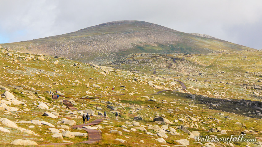
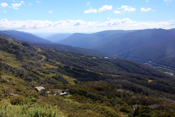
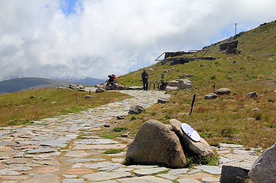
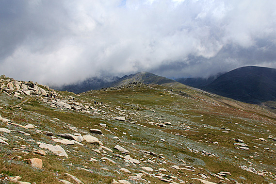
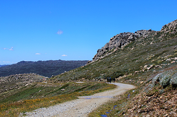
Relieved to be standing back on solid ground we walked through the small building to the other side from where we could see back down the Threadbo Valley carved out by a glacier in past ice ages. We were at 1930 metres above sea level. A sign showing a map of all the trails indicated the Mount Kosciuszko lookout was two kilometres away. The summit itself was 6.5 kilometres away. With just 298 metres to climb, this was potentially going to be a relatively easy mountain trek. The first leg of the track gradually ascends for about two kilometres to a place called “Kosciuszko lookout”, from where we will get our first view of the mountain. Unlike other mountains I have climbed in the past, this mountain didn’t stand out dominant above the rest. The reason the lookout exists is because from here we couldn’t see the top of the mountain at all.
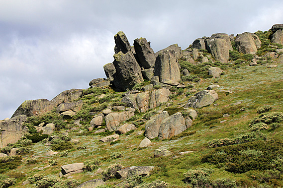
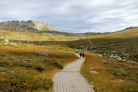
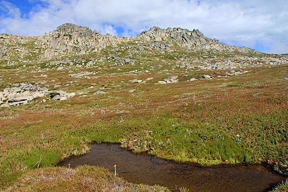
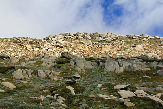
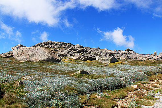
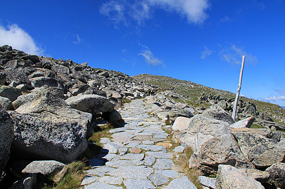
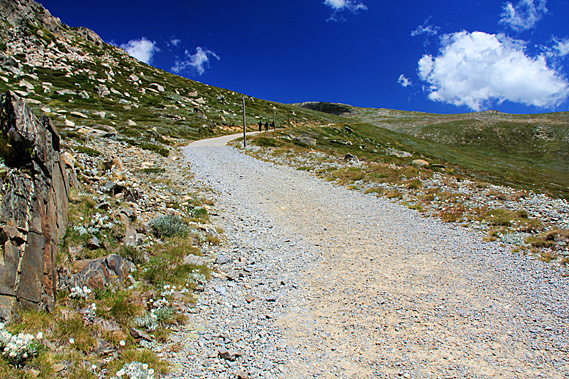
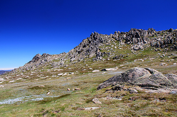
I knew the track towards the top of the mountain was going to be easy, but I was taken aback by the long cobblestone path laid before me. The hills rolled very gently over heathland broken only by the jagged rocky peaks of the Ramshead Range. There was a low saddle ahead of us. The Kosciuszko lookout was at the top of this saddle. The sharp crags of the Ram’s Head Range have been gradually formed when water has filled the cracks in the granite and frozen as ice. The broken off pieces have rolled down the mountain with some having been transported by glaciers during the ice ages or by landslides. Before this area became national park, pastoral grazers for over a century used to bring their livestock up here to graze the grasses during the short summers giving the vegetation in the lower altitudes time to recover and grow to produce enough grass for the long winter. A steady stream of hikers extended out along the cobblestone trail. There was no sign of snow but with the cold head wind it certainly felt like snow could be a possibility up here. It can snow here any time of year. Being the middle of summer though, there was no snow. In between the boulders scattered around the mountaintops healthy green grass grew with scatterings of wildflowers.
Just a couple of minutes out from the chairlift we reached the first track junction, a side track traversed across the side of the range under the craggy peaks of Ram’s Head Range to Dead Horse Gap about four kilometres away. Dead Horse Gap is a low saddle on the divide between the Snowy and Murray River systems. These two rivers drain the snowy mountains. From the top of Dead Horse Gap the track doubles back along the Threadbo River back to Threadbo Village.
By now my travelling companion who wasn’t experienced at all with alpine conditions started complaining about having shortness of breath due to the high altitude. Obviously he wasn’t used to the fresh air up here, but high altitude? I think not. We were still below 2000 metres above sea level. The effects of high altitude don’t even begin until 2800 metres above sea level. For me I hardly notice it up to 3800 metres above sea level.
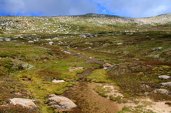
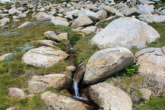
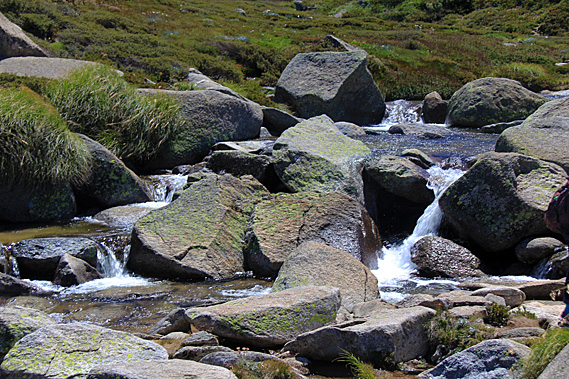
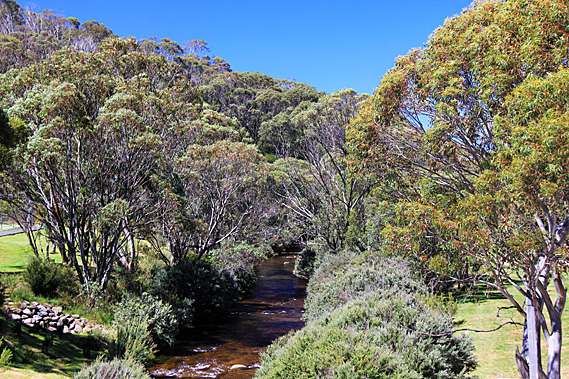
The cobblestone path rose over a very gentle ridge before gradually descending to a wooden bridge crossing over the Merritt Creek, cascading down through boulders. The 35 millimetres of rain overnight swelled the creek enough to give a good display without discolouring as expected when in flood. The stream tumbled down from the low gully spread out under North Ramshead, the mountain appeared quite dominant now. The cold alpine water roared its way between the boulders cascading in gentle leaps beneath the bridge then a couple of hundred metres further before leaping over the edge into a steep gorge in the Threadbo Valley.
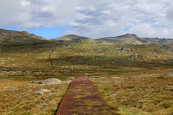
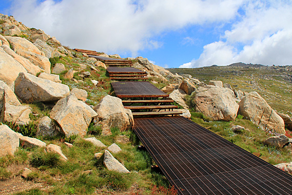
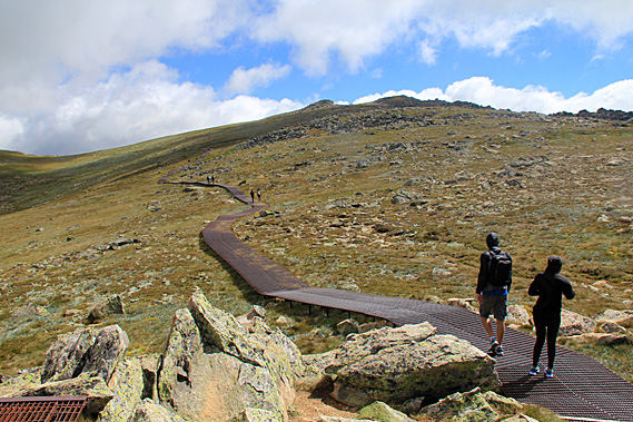
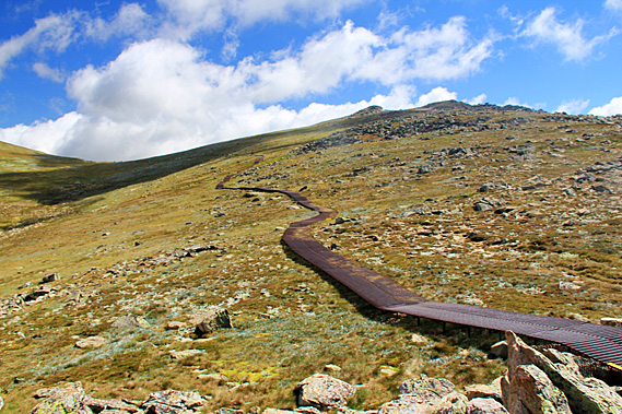
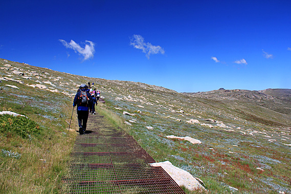
Once across the wooden bridge the trail climbed up a short moderate slope. The cobblestone path had ended at the start of the bridge. From here on the track was a rusting metal boardwalk elevated a little above the ground. The metal walkway was installed over twenty years ago as the traffic along the track was causing a lot of erosion due to the plants getting trampled and the soft soil being churned into mud. In the twenty years since the boardwalk had been installed the erosion had been almost completely healed with the subalpine heath scrub growing right up to and under the walkway. In most places this was elevated enough for small animals to walk under it along their own tracks.
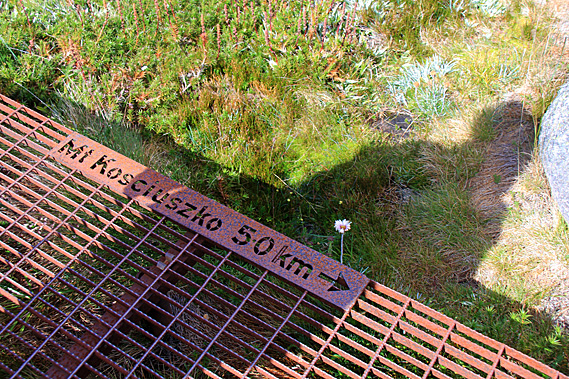
Despite warning signs to the contrary, the metal grating had a very good grip on it. The sign warned that it could be slippery after rain, ice or frost, but the rain hadn’t done anything to make it slippery thank goodness. My boots gripped quite firmly onto it. The tip of my walking pole sometimes got a bit stuck in the gaps though. Perhaps I should have brought the rubber tip that I had used on the Inca trail. The raised trail passed through the heathland where very low scrub sat tightly clustered together in anticipation of the cold winters surrounding small pools of crystal clear water that had formed with yesterday’s rain.
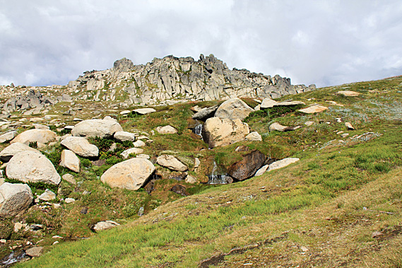
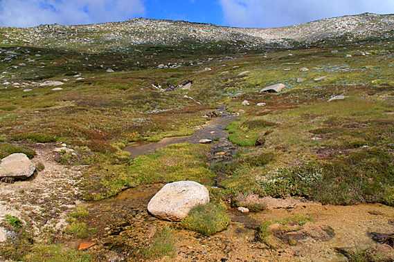
Most of the scrubby plants were out in flower making the most of the very short summer experienced at this altitude. Though it didn’t feel like summer. It couldn’t have been any more than ten degrees here, and with windchill, that dropped it to about three degrees. The track gradually ascended the increasingly rocky terrain towards a low saddle at the top of Ramshead Range. In the metal pathway was a small etched sign saying the mountain was five kilometres away. Along this track would be regular signs showing how far it was to the summit, and back to the chairlift. The track ascended very gradually until reaching the side of a small stream cascading through the boulders and grass. I figured this would no doubt be part of Merritt Creek. From there the track moderately ascended a stairway to quickly head up towards the low saddle.
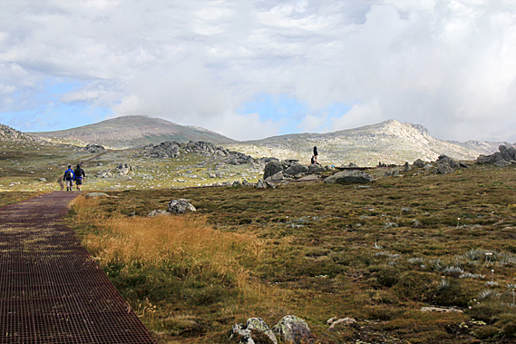
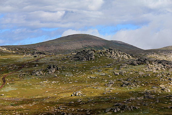
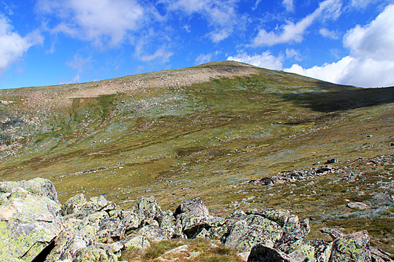
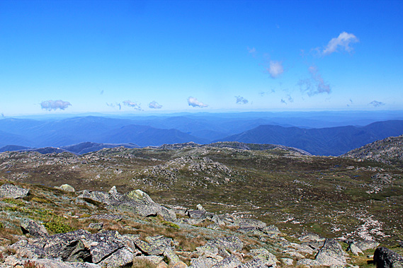
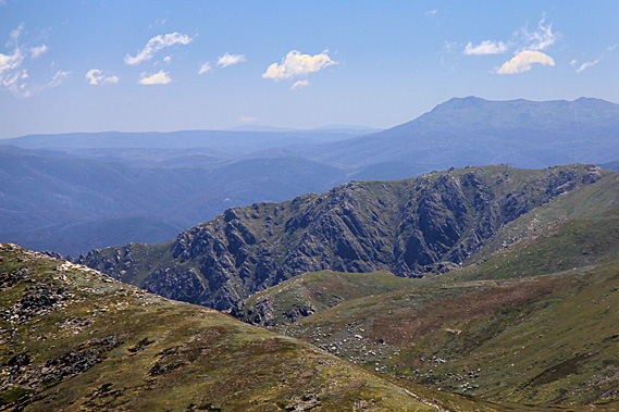
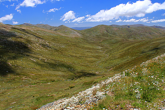
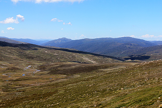
After the short section of stairway the saddle rounded off next to the towering hulk of North Ramshead. Looking ahead over the saddle I could now see the rounded dome of Mount Kosciuszko coming into view. On either side was a rockier summit that actually appeared higher. It was hard to believe the low rounded dome between them was the highest summit on the continent. It was hardly a bump. It was a far cry from Kilimanjaro which I had climbed a few years earlier, and almost nothing compared to Aconcagua, which I had seen out of a plane window flying northwards from Santiago. Those mountains definitely deserved their titles of being the highest mountains of their respective continents. Kosciuszko, on the other hand, was only a hill that stood but a few metres above the other hills of this large plateau of broken granite.
The Snowy Mountains were once a substantial mountain range extending the length of Australia’s East Coast when they were formed some eighty to a hundred million years ago. Towering peaks once rose above the surrounding landscape, but have over the many millions of years since been eroded back by snow, glaciers, and rain into the relatively flat hills we were exploring today. These mountains were now just a shadow compared to the Himalayas, the Andes, and New Zealand’s Southern Alps. This was the highest remnant of the Great Dividing Range. It is one of the few places in Australia covered in snow throughout winter. The snow melts in spring but patches often remain through summer into early autumn. We reached a junction in the track where a short forty metre metal track diversion climbing a few steps led across to the Kosciuszko lookout, our first stop for the day.
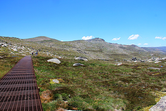
Overhead the clouds were quite thin letting patchy sunlight through. Occasionally the cloud would shroud the higher peaks. Below these peaks the plateau dipped from the saddle into a shallow valley. From the lookout the metal track descended into the valley before rising to another low saddle on the other side before disappearing into what I imagined would be the next and final valley before the summit. The route taken by the track followed the grass, deliberately avoiding the large scatterings of granite boulders on the steeper terrain. North Ramshead was behind us now. Its steep face was more obvious from this angle. The gentle saddle now hid the buildings of the chairlift and the Threadbo Valley from view, so from here it was only looking forward as we pressed on towards the top of Australia. Yesterday we had explored parts of the Snowy Mountain Hydro scheme at the bottom of the mountains. We were now about to go into where it all begins.
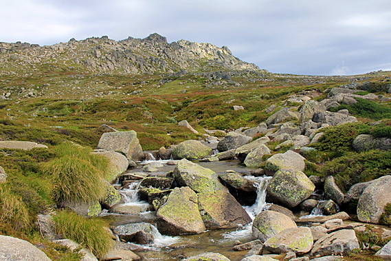
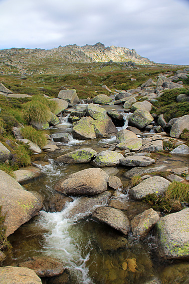
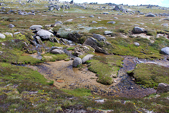
From Kosciuszko Lookout we returned along the short diversion back to the main track and continued following it gradually descending into a wide valley. The heath grass was actually growing through the grating of the elevated metal walkway, but it didn’t create any slip hazard. As we descended the wind started to ease off. Upon reaching the bottom of the valley we crossed the bridges of several streams that met just below the trail. The fresh overnight rain was making these streams flow well meandering between the clumps of scrub and around the grey boulders across the golden sand and gravel expected in granite. The water cascaded over small falls pooling together just below the track before flowing off downstream.
These streams are the headwaters of the Snowy River. The stream bubbles down the gentle incline of the valley accumulating with more streams to create the Snowy River, which is the main watershed feeding into the Snowy River Scheme that we had visited various sections of yesterday. Where we had visited were the lower levels, but this was where it all began. The river up here is fed mostly by melting snow in spring, and the rains of summer and Autumn. During winter cloud seeding is used to produce higher levels of snowfall to help the ski fields stay open for longer, for more water to feed the river during the spring melt, and also to provide more shelter for the pygmy-possum during winter. They move around in burrows under the snow to protect themselves from the predators on the surface. They need to have at least a metre of snow cover to remain safe.
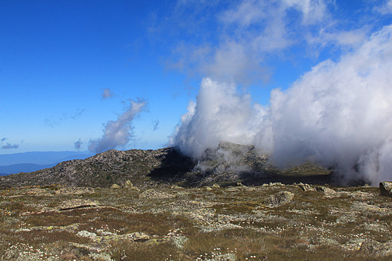
Once across the streams the trail began to ascend a more moderate slope on this side. Now we were serious about gaining altitude. It was all going to be uphill from here, apart from perhaps a brief descent after the next saddle. As we started ascending the metal track, with its occasional steps, the cloud overhead thickened. I could still see the summit ahead of me, but much of the time it was shrouded in cloud. Were we going to miss the view from there?
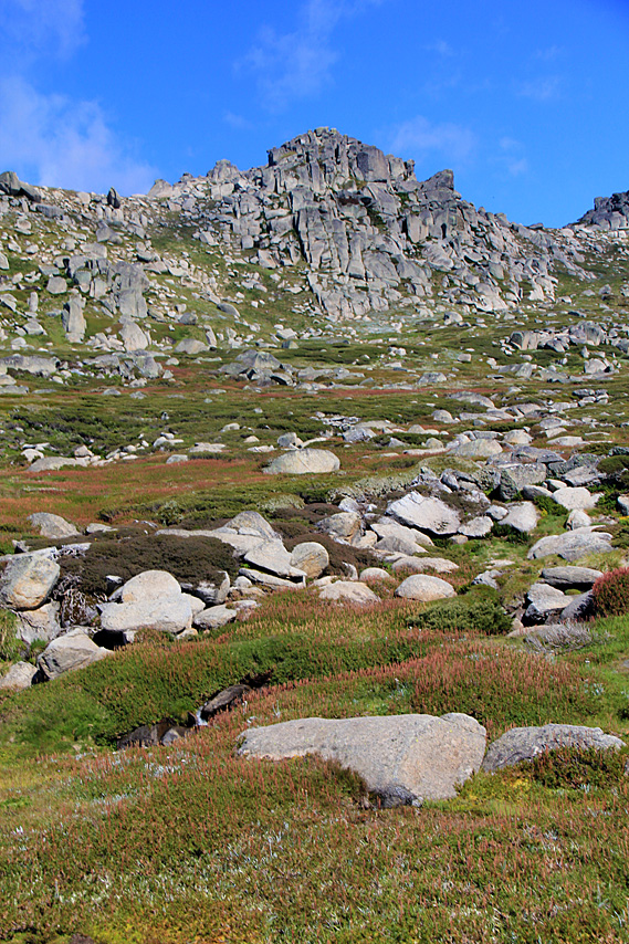
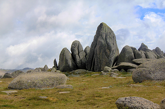
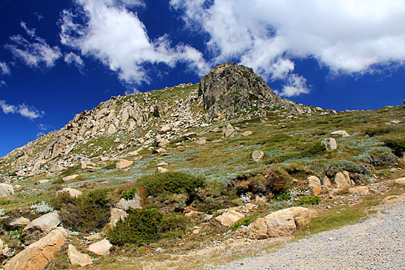
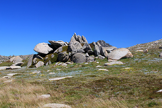
It was not long before we reached the top of the low saddle. This saddle was a little higher than the last one, but hardly significant at all apart from a stand of precipitous rocks standing to our right. They stood as obvious sentinels on the low hill next to the saddle almost as a huge guidepost to the mountain. The rocks certainly had a spiritual quality about them. The Aboriginal people consider the mountains of Australia a very spiritual place. The Snowy Mountains are by no means an exception to this. The people believe the spirits of the ancestral travellers live on the obvious landmarks, especially the large rocks and old trees. These dominant rocky outcrops we were passing would be of particular significance to them.
I do not know the spiritual stories of these rocks, but no doubt such a story would exist. The stories attached to these places have a very important role in cultural practice kept as a closely guarded secret by the elders. You have to earn the right for such information from the senior elders of the tribe. To the rest of us these stories remain a mystery. The Aboriginal people call this area Tubulluga. For them this is a very spiritual place similar to a church. The mountaintops are where the spirits of the ancestors dance.
The spirituality they ascribe to these mountains is enhanced by their long history. Aboriginal people have been coming here for hundreds of generations. Over these ten to twenty thousand of years, a very rich culture steeped in stories, legends, songs and customs have evolved here in remembrance of the tribes and individuals who have dwelled here. Some of these have been immortalised in place names, but otherwise these stories are passed from generation to generation by the local elders. Although the beliefs and stories vary from tribe to tribe, one thing they all had in common was their deep attachment to the mountains which are of great spiritual significance to them.
One thing all the tribes agree on is that the life on the mountains today is part of an interconnected system of relationships that began in the ancient times of ancestral beings. They shaped the landscape as they journeyed here seeking food and water. Some of these ancestors came in the form of giant animals such as kangaroos, emus, echidnas and wombats which all live on the mountains. Some of these beings from the north and the west ended their journeys here forming some of the landforms we see today. The traditional Aboriginal people didn’t have a written language. They didn’t have books to read from. Instead they relied on cues such as landforms and animals that live here.
The stories they told were very complex. If written they would fill many books, often taking weeks to tell and be accompanied by song and dance. These stories are available only to qualified Aboriginal elders. They came in search for the bogong moth. They also partook in ceremonies and to learn the ancient stories of the ancestral spirit world. They learnt to harness the resources in a sustainable manner ensuring everything was protected. They understood that everything is connected – every mountain, every rock, every plant, every animal and every micro-organism. Anything we change affects every other part of the ecosystem. They treated this area with respect. From the low saddle the track didn’t descend at all, instead it turned to the left clinging onto the slope heading towards the next saddle. The track ascended and descended negotiating its way around the field of rounded granite boulders having been exposed to millions of years of snowfall and erosion wearing them as rounded as you would expect around a large river or the coast.
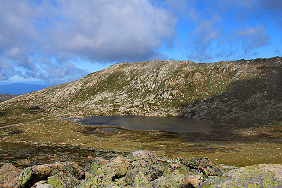
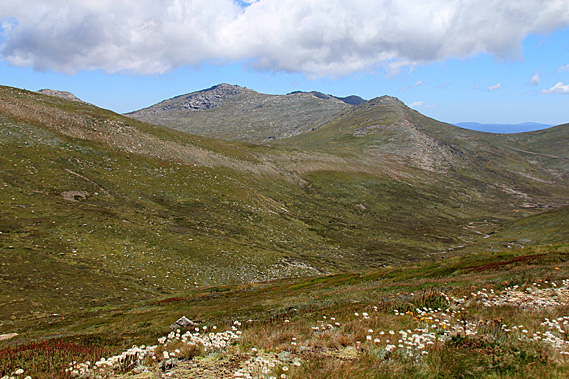
The mountain stood more obvious appearing a lot closer than it had before. We were definitely making progress. We crossed a couple more streams snaking their way down the gentle slope to meet the main ribbon of water of the Snowy River which was now visible down the valley. I imagined these streams would combine in a torrent during the annual spring melt feeding the lakes far below. The track became steeper as the terrain roughened ascending towards the next saddle. The wind was blowing significantly harder than it had done earlier this morning. Fortunately the steps didn’t last long as we crossed the saddle taking us out of the valley of the headwaters of the Snowy River. The Cootapatamba Lookout stood atop an exposed granite outcrop overlooking a small glacial hanging valley with a small lake at the bottom. The wind was blowing very strong here. Looking down from the lookout the valley plunged down towards the Threadbo Valley. The ridge I was climbing was perhaps the very top end of the Ramshead Range. The rolling hill of Mount Kosciuszko towered above the other side. A ridge from the mountain tapered off the other side of the glacial valley.
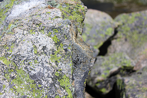
The lookout itself was a collection of huge granite boulders each covered in lichen that would have spent hundreds of years clinging for life growing in the very short summer growing seasons, and being buried by frozen snow for much of the year. Life was tough in these boulders where they grew. Despite that, the boulders provide excellent shelter for the heath and for the small animals that live here such as the mountain pygmy-possum and the bogong moth. Millions of bogong moths migrate here in early spring heading south from Southern Queensland to escape the heat of the lowlands. Their arrival provides a plentiful food supply for the birds and pygmy-possums. The bogong moth also provided a rich food source for the Aboriginal people when they come here during summer.
A small lake filled the bottom of the glacial valley. The glacier that had occupied this valley over the last ice age or two had carved out a depression which now held Lake Cootapatamba, Australia’s highest lake at around 1900 metres above sea level. The lookout was at about 2050 metres. This was the highest of the five glacial lakes in the park. These are the only glacial lakes on Mainland Australia. They contain the freshest water available on the mainland due to their low salt content and lack of nutrients.
Over winter the lake is covered in ice. Below the lake I could just see the Cootapatamba Hut, but it is for emergency shelter only as human waste is very destructive to the lake. The Aboriginal people called this lake Kau-oola-patamba – the place where the eagle drank. According to the local legend the ancestral eagle Maliyan who brought the bushfires to south-eastern Australia. He was responsible for the law of fire. The other two laws were wind and rain. Under the eagle the smaller raptors such as owls, kites and kestrels are associated with both wind and fire.
This lake was the drinking hole of the fire eagle. The rocky outcrops were the nesting sites for the eagle and the other firebirds. The loose rocks on the ground are the crumbs of the food the birds ate. The Aboriginal elders responsible for fire law met here at the lake every year to partake in their secret meetings and ceremonies. They would meet near Dead Horse Gap and head up the range to follow the path we have followed today before descending into Lake Cootapatamba. The two main groups of Eagle-hawk men were the Yerrung from south of the Murray River and the Merrung from the Monaro.
There were no eagles here these days, just the occasional crow. Today it was too windy even for crows. The strong wind ruffled the surface of the water. The lake ended in a small lip that no doubt formed the start of a stream running down the side of the mountain. Behind the lake were several marshes with small streams linking them thanks to the overnight rain. Much of the rock surrounding the lake and ascending the ridges was exposed, but there were large patches of alpine grass and heathland.
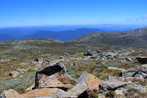
I could just see a tiny makeshift hut downstream from the lake. This is for emergency use only and no established trails lead to it because of the biological and cultural sensitivity of the area. After a brief rest at the lookout we continued following the metal walkway initially descending a few meters before starting an erratic ascent through the broken granite boulders. This led towards a low saddle around a kilometre away. Here the heath and grass grew only a couple of centimetres above the ground as if heavily grazed. The climate up here was tough for the foliage to grow in such a short growing season.
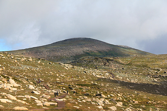
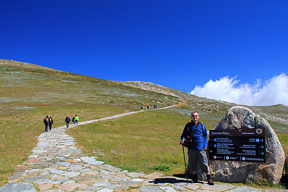
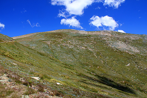
A large exposed area of rock lay across the front of Kosciuszko. This was the last area where the snow melts each spring. In some years the snow stays on well into summer. This year it had completely melted away. I could see several people resting at the top of the saddle ahead of me. This was Rawson Pass, the highest saddle in Australia. The trail steadily climbed leaving the lake behind in the old glacial valley. The terrain began to ease as it approached the saddle.
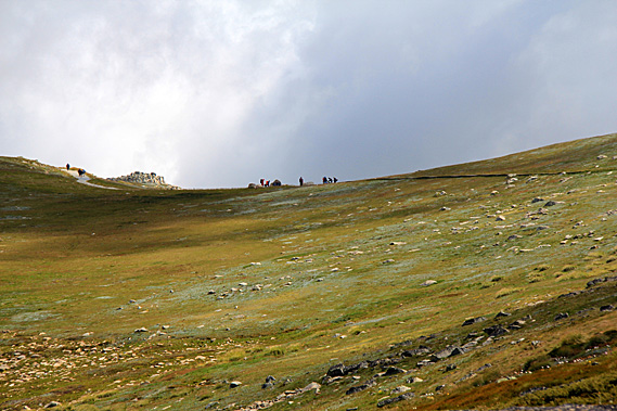
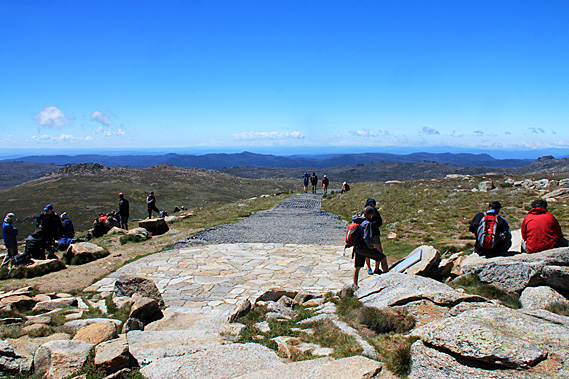
Eventually we reached the saddle. Here the metal walkway ended in a stone paved intersection. The track crossing the pass was wide enough to drive on. A sign on a large rock at the intersection indicated we were at Rawson Pass at 2100 metres above sea level. The track to the left gradually ascended towards the summit. The track going to the right passed some buildings set into the hill before steadily heading downhill to Charlotte’s Pass, where the current road begins. The road used to go along this trail to within a few metres of the summit. There were a number of large stones at the pass with plaques talking about the area. It was surprisingly busy here with the steady stream of hikers who had walked up with us from Threadbo meeting another stream of hikers who had come up from Charlotte’s Pass, meeting here as the final resting point before the summit. When you are this close to the summit, the feeling of anticipation suddenly increases. Knowing that the rest of the climb is easily achievable gives you a spark of energy compelling you to go forward with renewed vigour towards the goal.
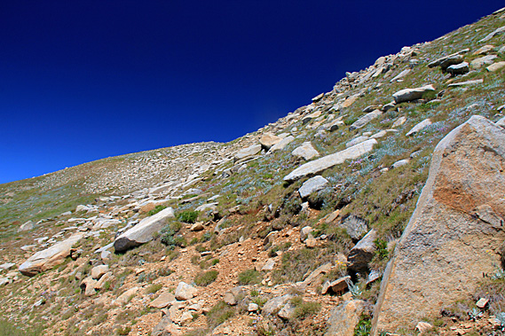
From Rawson Pass we began to follow the old road spiralling its way around the mountain towards the summit. The sky overhead was blue but most of the surrounding peaks were covered in thick cloud. Rawson Pass quickly dropped behind us and I could see the long scar of the old road heading down the side of the ridge to the glacial valley opening out towards Charlotte’s Pass and the Perisher Blue ski area. The cobblestone paving continued for about a hundred metres before reverting to a gravel road. A plastic honeycomb structure was set into the gravel to prevent it from eroding. This provided some good natural steps as the track moderately ascended around the side of the mountain.
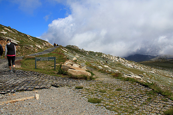
The terrain on either side of the track became steeper and rockier. Huge granite boulders lay scattered over the hill with alpine grasses growing in the sheltered nooks between them. About three hundred metres up from Rawson Pass we reached an intersection. The Main Range Track descended from the main trail. This was the main route around the alpine peaks heading back to Charlotte Pass. The Main Range Track and the old Charlotte Pass Road made a around circuit for fit hikers with a hut which they could stay in overnight a couple of kilometres down the Main Range Track. The main range track is supposed to provide spectacular views to the west before gradually descending to near Blue Lake, where the Aboriginal elders from tribes near and far used to meet at the annual hunt.
The unseen Blue Lake is the main camp of the legendary rainmaker, Dyillagamberra. The local Aboriginal people say the valley below us was also part of his territory. At the base of the valley I could now see the very small Club Lake. Many cultures consider a rainmaker to be a being that summons up rain. Whilst this is true, the Aboriginal people have a broader interpretation in that the rain maker also controls the rivers, the plants, the animals and the country itself, wherever water can be found. The Aboriginal elders who are assigned to associate with this spirit are also called rainmakers. The most senior rainmaker men meet at Blue Lake each year to hold secret meetings and ceremonies. They invoke Dyillagamberra to keep the rivers, springs, waterholes and swamps full wherever they travelled.
Dyillamgamberra has several sons. One of these is Garrugalla who lives in the clouds above the Main Range. He makes the winter snow (gu-nyinga), ice, frost and cold winds. He is helped by the nyinga ice spirits who live in the caves and rock crevices of the mountains. Garrugalla was definitely making his presence felt today. I could see a group of hikers in the distance approaching the intersection from the alpine trail. No doubt they will be diverting to climb the summit. They were all wearing backpacks and all looking very fit.
From the junction the main track continued rising moderately and heading around the mountain. The surrounding mountaintops were appearing lower now, and as one usually finds when reaching the top of a range the peaks all appeared at about the same height making the view a lot less spectacular than it had down in the valleys. By now we had reached the altitude of the bottoms of some of the larger clouds racing past. They seemed to be sticking to the mountaintops as they blew overhead. The track was turning with the dome of the mountain with Rawson Pass starting to disappear behind the hill. From here I could see the windward side of the mountaintop was clear. The fast wind was blowing high pressure air up the side of the mountain, then as it crossed the top, the pressure dropped causing the moisture in the damp air to condense as cloud.
Three metre tall wooden poles stuck out of the ground at irregular intervals. These poles are used as markers in winter when the ground becomes covered in thick snow, deep enough to hide the road we were following. Looking to the right across a mountainous pass I could see Mount Townsend, Australia’s second highest mountain. Mount Townsend was a lot rockier and rugged than Kosciuszko. It certainly would make for a more challenging climb. It was not often scaled as it was quite some distance away from the Main Range Track.
The well gravelled track continued its moderate ascent. The track was in excellent condition. New gravel had been laid here only recently. On either side of the track grasses and alpine flowering ground plants covered the areas between the rocks. Looking ahead though the terrain was about to become very rocky. Looking down northwards down from the mountain, the view was clear across the well worn ranges of mountains. The formless mountains and hills were a distinctive blue colour thanks to the oils of the gum trees that grew on them. The track changed from gravel to cobblestones as it passed through the field of giant boulders just below the crest of a ridge we were following.
Once past the boulders though, the terrain smoothed. The chaos of boulders was suddenly replaced by a gentle field of green grass with only a few small rocks sticking through the surface. The track returned to gravel with black plastic hexagonal patterning holding it all together. The track continued winding around the mountain as it continued gaining altitude. With increasing altitude the dome quickly got smaller making the turn a lot quicker. Soon I could see Rawson Pass again, now appearing quite a long way below us. From the pass I could see the long scar of the road heading down towards Charlotte’s Pass to the left, and the metal walkway slithering down the hill to the right.
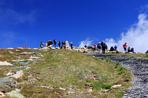
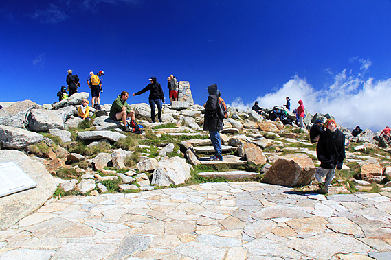
Looking up the track I could see a small crowd of people at the top of the dome, just thirty metres ahead of me. This was a very spiritual place for the indigenous people. Although they have been coming up to the Snowy Mountains for thousands of years, they very rarely climb the highest tops. The high mountains are close to the stars, where the spirits dance. They believe the spirits of the early travellers still live there. They were the old people who had gone long before them and remained here to guide the living. This was therefore taboo territory where one enters quietly and respectfully. Looking ahead the wide track led the way directly to a stone obelisk sitting on the summit. I was so close – nothing could stop me now. Whilst walking along a mountain trail, it is usually quiet with only a few people around you. I’ve always found it to be completely different at the summit of a mountain where a lot of people are gathered to make the most of being at the top before they head back down again.
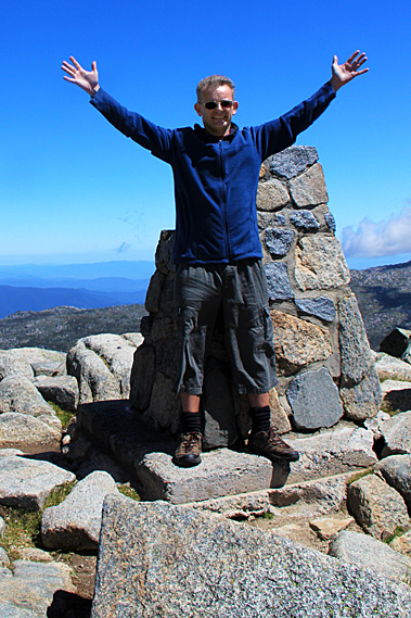
The gravel track ended in a small round area of cobblestones perhaps just wide enough for a four wheel drive vehicle to turn around having reached the end of the road. The road had closed in 1974, but was still in drivable condition. At the end of the road some natural rock steps led the final few metres to the summit. A large stone beside the steps had a large plaque giving some history of the mountain. The text on the plaque was a direct copy of a sign that had been placed here in 1940 to mark the centenary of Strzelecki’s ascent of the mountain 175 years ago on 15 February 1840.
Although Strzelecki’s ascent was the first to be recorded, it is highly unlikely he was the first person to reach the summit. Stockmen had been leading their herds in the mountains from the 1830s in search of summer pastures, so it is likely some of them would have climbed to the summit. This is not to mention the Aboriginal people who have been coming here for well over ten thousand years. Although the mountaintops were sacred to them, some will have ventured to the summits. The sky above was clear, but a large cloud was heading directly towards us. I briefly waited for my travel companion to catch up. He had gotten a bit breathless on the last ascent with the track having risen at a constant gradient since Rawson Pass.
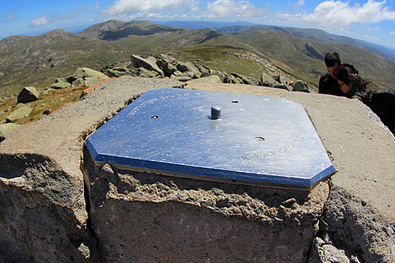
Together we climbed the steps and reached the summit, touching the top of the obelisk at the same time – no doubt in the same fashion that Tenzing Norgay and Edmund Hillary had done when they had summited Everest – the top of another continent. The obelisk sat atop a square block of concrete sitting amongst an assortment of large boulders making up the summit. The obelisk itself consisted of a number of granite boulders all cemented together with a stainless steel square plate on top with a screw thread in the centre to no doubt hold any surveying equipment used here. A small boulder at one of the top corners of the obelisk was missing. Apart from that it was in very good condition. A few others had their picture taken right against the sun. I arranged that we have our picture taken at the side where we weren’t going to have the sun behind us. We leaned against the obelisk as the wind was very strong here at around a hundred kilometres per hour. It seemed to be intensifying as the cloud suddenly made for a white background.
There was almost no vegetation up here. I figured that with thirty thousand people reaching the summit each summer, the grass didn’t stand a chance anywhere apart from in the inaccessible nooks between the boulders. The sun suddenly came back as I got my camera and we each did individual shots of each other. The lighting here was harsh – just as harsh as the biting wind. With celebration at the top of Australia all done, we headed downwind to some rocks where it was much better sheltered, even though still windy. From here we could just see Rawson Pass and follow the road heading down towards Charlotte’s Pass. The view was otherwise unspectacular. We were at the top of the highest mountain looking across to a number of rounded hills of similar height all tapering off into lower altitudes in all directions.
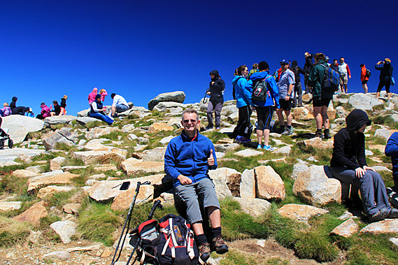
In the valleys I could see the streams all converging into the Snowy River to flow down to the hydro electric power schemes. Despite being the biggest engineering project in Australia’s history, it was completely invisible from here. There was no sign of civilisation apart from the trails that made their scars across the landscape. Otherwise it was exactly as appeared by the Polish explorers when they first climbed the mountain in 1840. Here we rested and ate lunch with all the other climbers who had too found rocks to shelter from the wind. There were about fifty, maybe sixty people up here either wandering around the obelisk, or sitting eating their food. More people would come, and those who had been at the top long enough began their descents back towards either Threadbo or Charlotte’s Pass.
The wind was blowing very strong against us as we descended the main track around the back of the mountain. By now the sky had completely cleared apart from a few small clouds over distant hills. Harsh shadows dropped down the sides of the boulders we were walking past. The view across to Mount Townsend was a lot clearer now. Somehow the peak didn’t seem so intimidating as it had earlier when menacing cloud had draped its summit. There were quite a lot of people walking down with us, and quite a number walking up assisted by the strong wind. A lot of people were successfully achieving their conquest of the top of Australia today.
The wind became particularly strong at the point where we turned around towards Rawson Pass. The wind always blows strongest around ridges as the terrain funnels the air past the mountain. Here it would have been blowing over a hundred kilometres per hour. Once around the point though the wind quickly eased off. It was a quick descent to the junction of Main Range Track followed by an easy drop to the junction at Rawson Pass. There was plenty of time to spare. The chairlift down to Threadbo wasn’t going to close until 5:30 this afternoon, so we still had up to five hours on the mountain. We therefore decided to head down the Charlotte Pass Road for a while.
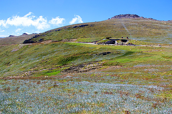
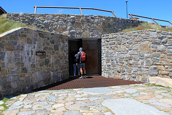
Just metres down the cobblestone road below the junction was a bike stand. Apparently you can cycle from Charlotte’s Pass to here, but leave your bike on the rack and walk the rest of the way to the summit. On a calm day this would be quite a nice ride, but with the wind pushing 80 kilometres per hour conditions would be treacherous for riding up against the head wind, and perhaps even more treacherous riding downhill with the wind. No wonder there were only a few bikes on the stand. Just past the bike stand a stone building was set into the hill. This would have to be Australia’s highest building, one of only two at above two thousand metres above sea level.
A large stone entrance led into a set of toilets. I needed to go so I went into the rather prison-like cubicles. It was rather cold even inside with its stone floor and stainless steel walls. I don’t think the temperature outside would have passed ten degrees today, reflecting the chill temperature in here. At least there wasn’t the wind chill to contend with. This toilet block was the highest building in Australia, and here I was taking Australia’s highest legal piss. Of course this wasn’t the highest piss I’ve ever had. Not including plane rides, the highest I’ve ever “been” was at 4820 metres above sea level in the little toilet block at Kibo on Mount Kilimanjaro. This was substantially less than half of that altitude and a good fifteen degrees warmer.
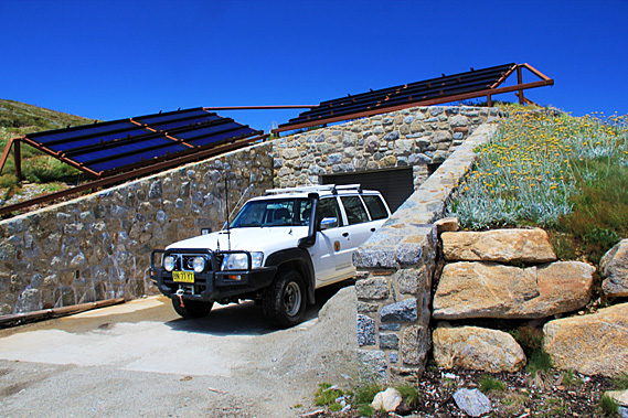
Once out of the toilet block we started walking down the road. There was another entrance to the building to the side. A large four wheel drive vehicle was parked there. Behind the vehicle was the ranger’s building. I’m not sure what it contained, but there were two large racks of solar panels on the grass above the building. It was quite a nicely landscaped stone building unobtrusively set into the hill, perhaps like what would be occupied by an alpine hobbit species. It was constructed from rocks concreted together in the same fashion as the obelisk at the summit. Just past the stone toilet block the cobblestones gave way to gravel as we continued to follow the road downhill in the hope of discovering more secrets of the mountain. Mountains have the potential to be very dangerous. Although these mountains are very easily accessible, they are no exception. Lives can be lost here.
The wind blew strong behind us as we followed the gravel road downhill through the yellowish green fields of alpine grass, broken by clusters of granite stones, and patches of alpine flowers in full bloom making the most of the very short summer. Tall wooden poles stuck out of the ground along the side of the road. These were markers for travellers attempting to follow this road during winter. No doubt the snow would sometimes get deep enough to cause the road to completely disappear. Looking back to the ridge of Mount Kosciuszko, there was a strip of bare rock stretching from just left of the summit across to the right and heading all the way down the ridge across the other side of the valley. This was the resting place of Gadi Maralang, the Brown Snake.
Stories of the Gadi are abundant throughout Australia, where long valleys are often associated with its travels. Here the local story tells of a time before time when turtles were venomous and snakes were safe. The snake slid into the turtle’s camp in the valleys below and stole it’s venom. He then distributed the venom to other snakes whilst the turtles chased them. Some of the snakes did not accept the venom and fled into the hills, creating the valleys that radiate from the Snowy Mountains as they fled.
Maralong journeyed north along the Great Dividing Range creating valleys until he was stopped by the rainforest python spirit. He turned and slid into the deserts. The turtles continued chasing him until he returned here to Tidbillaga where he remains to this day across the rocky escarpment running across the mountains. Geologically these are caused by the last snows to melt staying here for much of the year preventing any vegetation from growing. When the snow does melt, stony ground is exposed.
The track continued heading downhill, with quite a bit of hill above us. A stream plunged down beside the road and passed over a small ford. Looking ahead there was a large outcrop the track seemed to be winding its way around. I had no idea how much further Charlotte’s Pass was, or if there was anything in between, but I knew we had to turn back sometime soon. We passed a cyclist coming the other way. The head wind was too much for her to ride up the moderate slope forcing her to walk beside her bike pushing it along. Even that was quite an effort in such strong wind. There were a few other people walking as well. I became worried that cyclists may suddenly appear from behind travelling very quickly with the gravity of the downhill plus the force of the tail wind. There was the potential to speed very dangerously along the track.
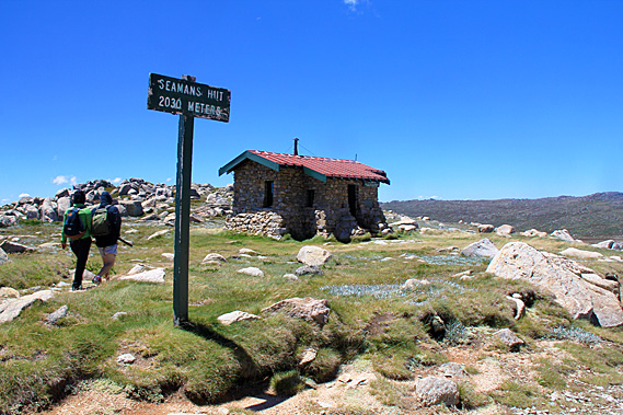
Below us the valley was getting wider. During a past ice age a glacier would have filled this valley. Now a stream meandered its way across the bottom, occasionally forming a small lake. On the other side of the ridge unseen was Blue Lake. This was where the indigenous people used to meet on their annual journey up here. Beyond that the valley dropped off into the montane forests of the Perisher Valley. The bluff we were heading towards became more prominent as we continued to lose altitude. The ridge flattened in front of the bluff allowing the track to cross over it. Ahead was a small knoll. To the right of it was a low saddle where the track continued. A small stone hut was nestled in the saddle. Beyond the saddle a low featureless ridge rose in the distance.
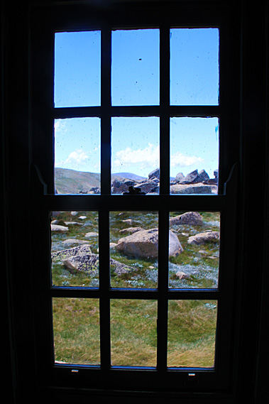
The wind was blowing fierce around the bluff creating a wind tunnel in which the hut was directly exposed to. The tiny stone hut had a small metal chimney rising from its red metal roof. It appeared very small. No doubt it would feel very small on the inside with the large rocks that were cemented together. A short distance in front of the hut was a simple sign saying “Seaman’s Hut, 2030 meters”. The hut had a sign above the front door. “Seaman’s Hut. For day use and emergency overnight shelter only.”
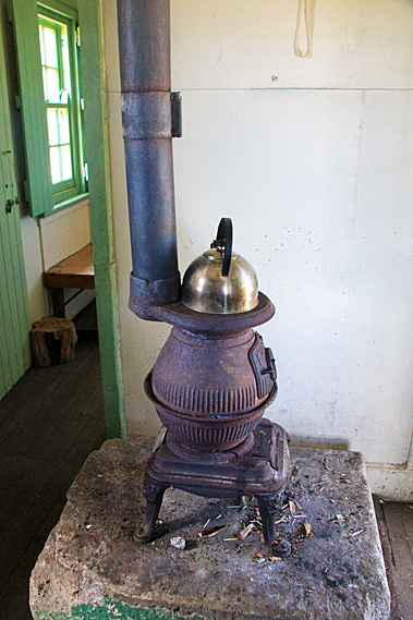
We entered the hut, thankfully getting out of the strong wind. Immediately inside the front door was a storage area where firewood was drying out. An internal entrance led into the main living room where a small metal pot belly stove stood on a large stone slab with a kettle covering its entire top. I thought this would be quite a cosy place to stay if you were stuck out here at night.
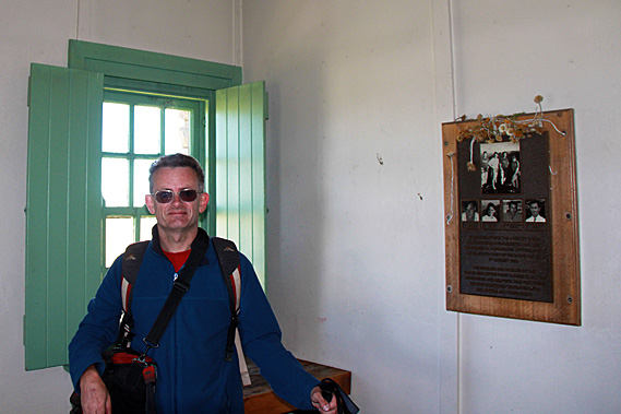
From the tiny living room a doorway led into the sleeping quarters. There were no bunks here. Instead there were a few hard benches for sitting on. The room had a small window and a bronze plaque mounted on a piece of wood. The plaque had photos of some young people and a commemoration to their death nearby on the mountain.
“To commemorate the lives of these four young snowboarders, who lost their lives in a snow cave approximately 1.5 km south east of Seaman’s Hut on 7th August 1999. The families and friends of the young men offer their thanks to all the searchers and helpers who for three months continued to search with dedication and compassion.” The plaque gave the names and ages of the four guys who had died.
“Dean Pinchini – aged 25, Tim Friend – aged 25, Scott Beardsmore – aged 26, Paul Beardsmore – aged 24” We looked at the time and decided this was as far as we should go today. The track continued heading downhill to meet with the Snowy River. From there it continues down the valley to meet the majestic twisted snow gum forest treeline at Charlotte’s Pass. There wasn’t enough time to do this. We needed to return up the road to Rawson Pass and follow the metal track back to the chairlift before it closes down for the night. The Aboriginal stories here tell of three challenges thrown by the spirits who dance on the mountaintops – snow, fire and wind. These three elements have the potential to make an otherwise easy stroll through these mountains very challenging.
The wind outside Seaman’s Hut was so strong, that I had difficulty standing. It was going to be tough climbing uphill against the powerful wind. We slowly paced our way up the road. No sooner had we rounded the bluff, the wind eased off significantly. It must be a real wind tunnel through there. To me this seemed to be a crazy place to build a hut, but it was the only reasonably flat surface. We continued heading up the hill making good pace. The wind was still quite strong, but not strong enough to hinder our progress.
Looking ahead I could see the road sweeping around the ridge towards the pass. Beside the path grew lots of white flowers from silver leafed plants. Beyond the pass the rounded dome of Mount Kosciuszko stood rather dominant with its large face and no obvious peak. There were still quite a few people up there though, sheltering on this side of the summit as we had done around an hour ago. The wind intensified as we approached Rawson Pass. We had made the climb in good time, in fact less time than it had taken us to walk down the road earlier. At the pass the wind was blowing very strong, at around a hundred kilometres per hour.
We didn’t linger at the pass for long. We started following the metal track with quite a few other people who were on their way down from the summit, including a couple of family groups with young children. The wind intensified, now blowing well over a hundred kilometres per hour. It became difficult standing on the metal track. Thankfully I had my walking pole to help me keep my balance against the gusts of wind. A particularly strong gust hit just as I was crossing a small rise. Thankfully with the help of my walking pole I managed to maintain my balance. About fifty metres in front of me two children were blown right off the boardwalk into the grass. Thankfully their landing was soft. From then on their parents carried them. It was rather too dangerous for them up here.
We continued battling the ferocious tail wind along the metal walkway to the Cootapatamba lookout. From the lookout the track quickly descended behind the ridge where the wind died off significantly. From there we started the moderate descent towards the headwaters of the Snowy River. Apart from the occasional step it was an easy grade descent. The wind was usually bearable except in a couple of places where we crossed an exposed area below a saddle and be blasted by the wind again. We were travelling at a good pace with the fairly large group we had somehow inherited. They would have been a little late getting up the mountain, and were all heading back down together.
As the altitude decreased we began to encounter the interesting rock formations we had passed this morning. They appeared quite different to what they had done this morning. The overhead cloud had softened the landscape into ominous muddy colours. Now under full sun the rocks showed their wrinkles with harsh shadows and bright colours. Upon reaching the gully at the head of the Snowy River, the streams were still running strong. I had expected they would have diminished a little with rain having cleared, but they didn’t show any significant change to what I had seen this morning.
Climbing the other side heading towards Ramshead Range, the pools of water in the heathland were still full and crystal clear. The wind began to intensify again as we gained altitude on the short rise towards the Kosciuszko Lookout. Once over the low saddle we headed down the stairs of the boardwalk into Merritt Valley. The wind was blowing strong throughout the short descent. The rocky crags of Ramshead Range didn’t seem so ominous now.
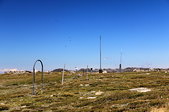
It was not long before we reached the bridge over Merritt Creek. The creek was still running high with crystal clear water tumbling over the rocks up to the grassy bank on either side. Once over the bridge we were back on the cobblestone path walking the final leg gradually uphill towards the chairlift. Ahead I noticed a weather station sitting amongst the barren heath. The wind vane was spinning very fast in the strong tail wind. Once past the weather station, the trail gradually descended to the chairlift.
I had recalled the chairlift ride being very scary this morning, but at least we were facing towards the slope this morning. Going back down the mountain we will be facing the valley – all 540 metres of it. We were at 1927 metres above sea level. Looking at the chairlift I figured it would be okay up till the first structure, then from there the descent will be steep. I will probably have to keep my eyes closed and hang on tight for most of the descent. Then there was the strong wind. I recalled the carriage swaying in the wind this morning. It was blowing a lot stronger now.
There were a lot of cyclists riding the chairlift up the mountain and then cycling down the ski slope. There were also quite a few walkers here who we had hiked with since Rawson Pass. We walked up the short ramp to the chairlift. It was then I realised there was a bar you pull down to secure yourself. We stood in the designated spot to get collected by a chair. I pulled down the bar and suddenly felt very secure with a bar in front of me and another part lower down to step on.
The chair extended out from the building towards the first tower. It was a little hairy with the strong wind blowing us from side to side a little. Once past the first tower the chair descended steeply down the side of the mountain. The sun was still high and the clouds were all very distant by now, so the view along the Threadbo Valley was very clear in both directions. The town stood at the bottom of the valley over half a kilometre below. A cyclist on a mobile phone passed us heading up. His bike was attached to the back of his chair. I wondered how many times he had gone down the mountain today. There were quite a few people on the lifts heading up, mostly cyclists, but there were a few walkers as well. Anyone walking up here this late in the day would be lucky to get to the Kosciuszko lookout and back before the chairlift closes.
Going down the very steep section wasn’t as bad as I thought. Having the safety bar in front of me was a big help. A family with a baby passed on the other side, then the next chair had a rather bogan young couple wearing singlets, shorts and thongs – hardly the attire to wear up a cold mountain where the temperature was only around five degrees not to mention the wind chill from the 80+ kilometre per hour wind. We began passing the montane forest. Large patches of dead trees were amongst the live ones. The slope gradually eased until we were eventually over the little spur before the final drop to the building at the lower end of the cables.
Upon entering the building and finding our feet on firm ground again, we left the chairlift building heading back across the bridge towards the main town. I was surprised at how warm it was down here. There was not a breath of wind in the perfectly still air and the temperature was at least twenty degrees. Taking wind chill into account it was 25 degrees warmer down here than it had been at the top. No wonder the bogan couple weren’t wearing much. I’d guess they wouldn’t stay at the top very long at all and will be very quickly heading back down here. Obviously they hadn’t taken any notice of the noticeboard at the bottom where it said the temperature was 3 degrees with 80km/h winds.
We walked across the bridge over the pristine Threadbo River. Under the bright cloudless blue sky the water was a clear ochre colour from the tannin of the vegetation it had leached. The town stood quiet in the relative downtime of summer. Without the hiking and cycling it would be a ghost town here for most of the year. I imagined it would be very busy here during winter. We walked through the shopping area to a park with a small lake surrounded by the chalet resorts before driving back down the valley towards Jindabyne. |
||||||||||||||||||||||||||||||||||||||||||||||||||||||||||||||||||||||||||||||||||||||||||||||||||||||||||||||||||||||||||||||||||||||||||||||||||||||||||||
|
||||||||||||||||||||||||||||||||||||||||||||||||||||||||||||||||||||||||||||||||||||||||||||||||||||||||||||||||||||||||||||||||||||||||||||||||||||||||||||