|
||||||||||||||||||||||||||||||||||||||||||||||||||||||||||||||||||||||||||||||||||||||||||||||||||||||||||||||||||||||||||
|
||||||||||||||||||||||||||||||||||||||||||||||||||||||||||||||||||||||||||||||||||||||||||||||||||||||||||||||||||||||||||
Home > Treks > Outside Australasia > Inca Trail > 6 |
||||||||||||||||||||||||||||||||||||||||||||||||||||||||||||||||||||||||||||||||||||||||||||||||||||||||||||||||||||||||||
|
||||||||||||||||||||||||||||||||||||||||||||||||||||||||||||||||||||||||||||||||||||||||||||||||||||||||||||||||||||||||||
Introduction to today's journey…So lofty are the peaks on either side that although the trail was frequently shadowed by dense tropical jungle, many of the mountains were capped with snow, and some of them had glaciers. There is no valley in South America that has such varied beauties and so many charms… …Not only has it snow-capped peaks, great granite precipices, some of them 2000 feet sheer, and a dense tropical jungle, it has also many reminders of the architectural achievements of a bygone race… …We had a hard climb; first through the jungle and later up a very stiff, almost precipitous, slope… …(until we arrived at) the top of the ridge. On all sides of us rose the magnificent peaks of the Urubamba Canon, while 2000 feet below us the rushing waters of the noisy river, making a great turn, defended three sides of the ridge, on top of which we were hunting for ruins… …The superior character of the stone work, the presence of these splendid edifices, and of what appeared to be an unusually large number of finely constructed stone dwellings, led me to believe that Machu Picchu might prove to be the largest and most important ruin discovered in South America since the days of the Spanish conquest. - Hiram Bingham, Archaeologist, 1911 (Adapted from the National Geographic, 1913) Today's trek departs Winaywayna ascending to the Sungate. From there we descend into the mysterious Machu Picchu. After exploring the city, we head back out to Cusco. Today's JourneyDistance trekked today: 9 kilometres. Total distance trekked to date: 55 kilometres. IT WAS totally dark when we were awoken at four o’clock in the morning. I got dressed and took my gear out of the tent, taking care not to fall off the edge of the near vertical slope dropping hundreds of metres in the darkness to the river far below. The sky was obviously overcast as there were no stars or moon visible.
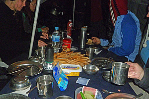
We met in the breakfast tent where the porters provided us with a quick breakfast of toast and tea so they could pack up and run down the hill in time to get their five thirty train back to Cuzco. Once more Wilbur gave us the invitation to go to Wyanu Picchu, the steep mountain on the other side of the city. I had weighed up my options, and decided it would be a lot better to spend my time exploring the city rather than go on another climb. Marissa and Amanda put up their hands to climb it. If they are lucky there will be a few tickets available by the time we reach the main park entrance, so they would have to cross their fingers and hope to get them. By not going I didn’t have anything to stress out about.
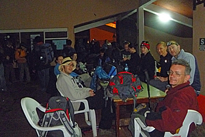
Once breakfast was finished, Wilbur and Carlos led us along the dark pathway at the edge of the cliff to the main restaurant which to my surprise was already crowded. Everyone else was waiting for the gate to unlock at five thirty whilst all their porters were doing the mad dash along the narrow path down the mountain to get their train. Despite the restaurant being crowded, we actually found a table big enough to fit our entire group. Now you would expect the restaurant to be open and someone serving food like there had been at Laban Rata on Kinabalu at two o’clock in the morning when I had climbed it earlier this year. To me this was a missed business opportunity for the owners of this hut. Everyone was therefore just sitting there rugged up in their coats looking very bleary eyed murmuring whatever they could think of to say in this insane hour of the morning. I recalled just a few days ago of telling everyone else in our group that I have been waking up at four o’clock every morning since the start of the trip, but that had stopped when I had arrived in Cuzco. I guess the altitude had increased my desire to sleep.
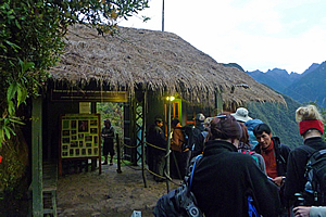
It was just starting to get light when we left the hut and walked along the track to the gate. The valley below us and the mountains on the other side were very gloomy in the early morning twilight. There was quite a long queue at the gate. Now I had remembered what Luis had told me a few days ago. If they see that you have a big camera when you go through the gate, then they will charge a special tax on the basis that the owners of big cameras are either very wealthy or working professionally. I had taken his advice in concealing my main camera in my bag, and I made a point of waving my little credit card camera around in a Mr Bean style to make me look like an obvious amateur.
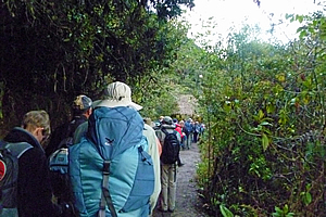
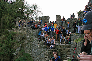
The gate opened, and they allowed us all to go through group by group. Finally it was our group’s turn. We entered the small thatched hut without walls. It did have a couple of internal walls with displays, but it was still a bit too dark to see them. We all got through okay, and fortunately the man at the counter didn’t see my huge camera concealed in my bag, so I wasn’t charged the “wealthy photographer’s tax”. As we passed through, I looked behind. There were quite a lot of people behind us, so the track was going to be quite crowded all the way to Machu Picchu. The track was rather crowded as we shuffled single file up the gentle uphill slope towards Machu Picchu. The sky lightened turning the clouds covering the jagged peaks from a soft purple blue to an angry yellow colour. The peaks themselves were still black. In between the peaks slithered purple glaciers tumbled down in suspended animation. The silver river snaked the bottom of the valley far below us.
We walked around the back of a steep gully onto Machu Picchu Mountain. The city was just on the other side of the mountain. Once more we entered thick cloud forest denying us our long distance view for a bit longer as the trail narrowed and went up and down against the precariously steep terrain. I was amazed that it could support forest. Small ferns grew in the cracks in between the rocks of the retaining wall to the left of the track. Tree ferns appeared in the forest, giving the area a starkly New Zealand look about it.
The track began a constant ascent rounding a point rewarding us with a spectacular view of the valley below. We were close to the edge of the forest, after which was cleared land as we had seen on the first day of the hike. The track seemed to get more crowded as it steepened. Soon it was almost all steps as we shuffled along in a moving queue, climbing up in amongst a ruin in the thickening cloud forest. Then we were suddenly crossing over a pass in between the two pillars of Intipunku - the Sungate. We passed between the perfectly formed stonework to regroup with the rest of my group on a ledge to the left of the main gate. There we awaited the sun to rise.
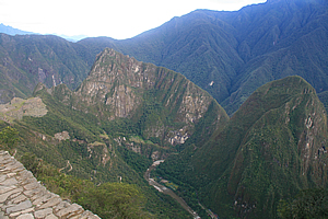
We were sitting on top of a flat rock wall about two metres above the track near the top of a precipitous rise, dropping almost vertically some seven hundred metres to the roaring river below. Well it would be roaring if we could hear it. It was too far away though. I could just see a long train snaking its way slowly along the bottom of the gorge, bringing tourists to our destination. The mountains on the other side of the river rose almost vertically to their domed forested summits. How any vegetation could cling onto them beat me.
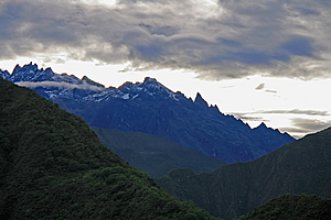
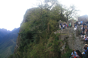
Way up here on the mountain, we were almost at the edge of a large crag. Intipunku occupied a small col before the small hill that dropped off vertically in every other direction. Small trees and bromeliads clung on for dear life on this hill. The two pillars of the Sungate stood oblivious to the surrounding vertical terrain. For five hundred years these pillars have directed over a hundred and eighty thousand sunrises towards Machu Picchu. From here we were supposed to see the sun rise above the mountains beyond and send a ray of light from in between the pillars to the city of Machu Picchu about two kilometres to our left.
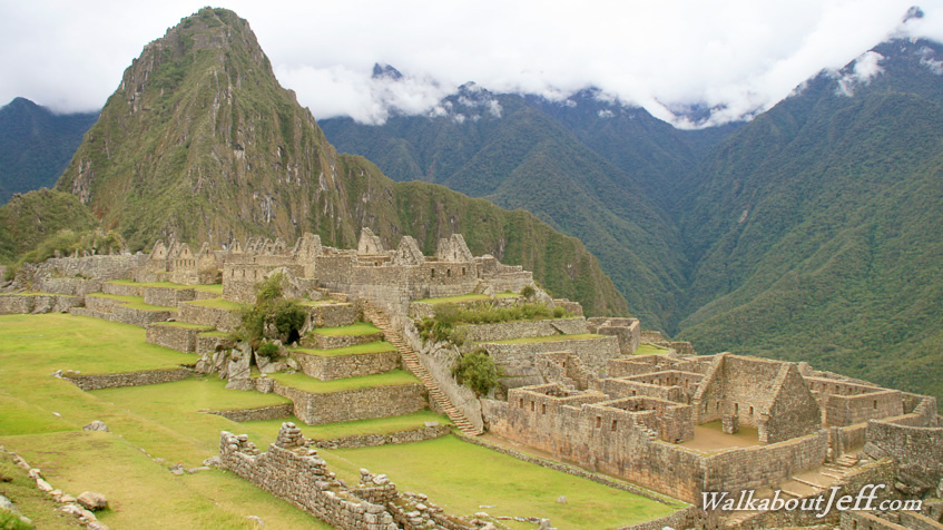
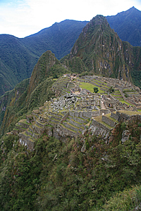
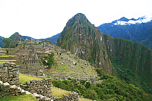
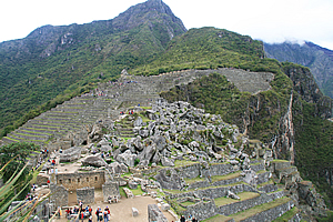
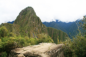
I could recognise Machu Picchu clearly, though I had never seen it from this angle before. The two thousand seven hundred metre high mountain of Waynapicchu (Young Mountain) had a much more gentle slope on the other side as it descended into the river. This side of the mountain, rising to about our altitude, was a vertical slab of rock forcing the river to pass around it. The city itself was clearly recognisable clinging onto the saddle at a surprising distance below us. This was the culmination of our journey, yet it was at the lowest point of the trail. We had started at two thousand six hundred metres above sea level, climbing to over four thousand two hundred metres before dropping to about two thousand seven hundred metres here. All we needed to do now was drop to two thousand three hundred and fifty metres at the city.
The track followed the side of the mountain down to the city. This was our next leg of the journey. The city appeared quite strange from this angle. I had seen many photos taken from one location a lot further track, but not from up here. The mountains beyond the city seemed to be strangely flat along their ridges as they tapered away towards the Amazon. Before heading down the hill though, everyone who had walked the trail this morning was sitting on their vantage points up here at the Sungate – a spiritually significant location. If it wasn’t overcast, we would have seen the sun rise and seen where the Sungate passed over the city. The overcast conditions prevented us from seeing it happen.
Looking back towards the city, I could see a road zig-zagging up numerous hairpin bends towards a car park and a building that was obviously the entrance to the city. Buses were starting to wind their way up the hill delivering the first tourists of the day. Finally it was time to go. A lot of the other people left and started the walk whilst we took a very good vantage point for a group photo, loading up Wilbur with all our cameras – I got a very good shot of him holding all of them. We then left the Sungate and started the legendary decent to the city of Machu Picchu.
|
||||||||||||||||||||||||||||||||||||||||||||||||||||||||||||||||||||||||||||||||||||||||||||||||||||||||||||||||||||||||||
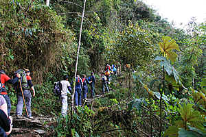
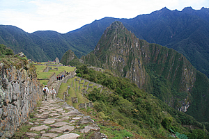
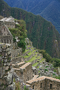
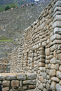
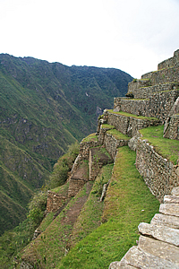
Trail to Machu Picchu |
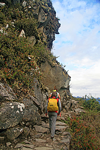
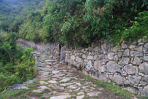
The trail was quite wide, flanked with one perfect stone wall above and another one below the track holding it all in place. It was wide even where it passed one section around an almost vertical bluff.
Trail to Machu Picchu |
The track itself was quite worn with soil over most of the stones. I guessed it was worn because many people would walk up to the Sungate from Machu Picchu.
We walked down until we reached a small ruin about half way between the Sungate and Machu Picchu. The ruin was a single level containing what had been several stone buildings that seemed to have had flat roofing. That seemed rather unwise in such lush scrubby jungle. There were a few stone staircases leading up to more ruins in the scrub. Curiously none of the walls were plumb. Some blocks of walls were tapering out and others were tapering in.
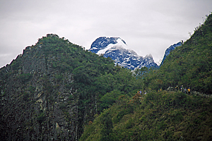
Looking back to the Sungate |
From here I had a spectacular view back up to the Sungate, with the jagged snowy peaks directly behind. I took some very interesting photos of it, including some of the people walking around the precipitous ridges. From here we could see the vertical strata of granite, indicating this entire area has been turned on its side during the uplifting of the Andes.
We continued walking down the track moderately downhill now nearly wide enough to drive along. We passed what seemed to be a quarry with a couple of buildings. Perhaps it was here that some of the rock to build the city was excavated.
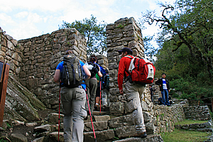
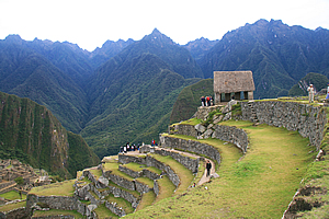
Entering Machu Picchu |
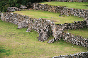
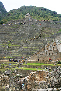
We continued until it eventually opened out into several stone walled terraces with low grass growing on them. This marked the top of the city. There were several llamas there all wearing brightly coloured red and green tassels. Now we were getting close to civilisation. I guessed this area had been used to grow the fine foods including corn that the Incan emperor had eaten whilst on retreat here.
Aside from the terraces, there was only one visible building. It was a small house with steep roof, but this one actually had thatching on the roof. It was hard to believe there would be an entire city below this house. We followed a rather deep furrow along one of the terraces to the far end. The terraces were unbroken apart from some steps ingeniously sticking out from the stone walls at exactly the right places to allow you to easily climb up.
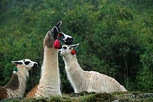
Alpacas at Machu Picchu |
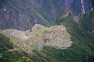
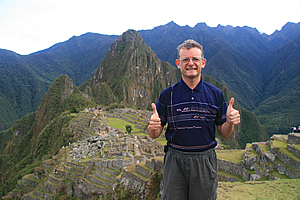
We were near the end of the ledge when I looked over it, and saw the classic view of Machu Picchu, and the ledge from where people stood to get the classic photo taken. There were quite a lot of people already there as expected, but we had finally arrived at the legendary lost city of the Incas, built in the 1460s, having never been found during the Spanish inquisition. Having been lost and overgrown never to be visited for over four hundred years until it was finally discovered in 1914. This truly was a lost city rediscovered.
There are a few scenes in the world that are so photographed, that the images stick in the memory even though you have never been there before. Finally when you do arrive, you look at the scene in three dimensions, hear the sounds, smell the smells and feel the surroundings, although it is so familiar to you, it seems surreal.
Looking to the right from the viewpoint |
That has happened to me before when I visited Milford Sound in New Zealand, seeing the scene of the mountains sweeping around the fiord for real. Now I was in another place so indelibly etched in my mind, but I was seeing it in the flesh. I had to pinch myself. I really was at the legendary city of Machu Picchu.
Despite all the photographs I had seen, and despite all the photos I was taking, no amount of photography of this scene I had seen in the past would prepare me for this experience.
We climbed down to the next level, the level where people get their photos taken. The wall we climbed down had four carefully located stone steps sticking out of the wall making for a surprisingly easy descent.
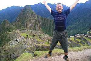
Success!!!! |
Now this was one shot that I didn’t want stuffed up, so I was close to Amy, who had the same model camera as me, and who I had been teaching a few things about shot composition, so by now she was primed up ready to take my shot. I handed my camera over to her and let her work her magic confident that I was getting some good shots.
Then we swapped over. I took her camera and took a few shots of her. I had lent her my spare polarizer, but for some reason she had never used it despite me telling her that it adds a lot more colour to the photos. Without the polarizer I feared the shots I was taking of her using her camera were going to be a bit washed out as if often the case with Japanese cameras.
The view from up here was stunning. We were very fortunate that the clouds were high above us. Quite often the view is disappointing with the clouds settling deep in the valley blocking the view. This morning we had a clear view, and fortunately there weren’t many people in the city yet. It was surreal actually being in a place where you had seen so many photos of, and it was an instantly recognisable area. Being there was totally different though. Sure I had seen this place many a time, but actually being here and experiencing it was truly amazing.
Success!!!! |
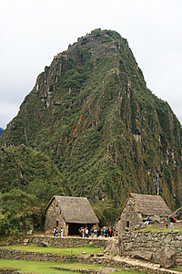
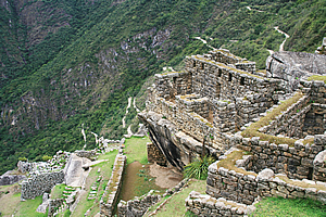
About a kilometre ahead of me was stood the towering obelisk of Waynapicchu. The city of Machu Picchu stood on the saddle between where we were standing and the cliff face. The saddle swept off to the right before meandering back to the cliff face. There was a moderate slope to contain the terraces of the city. Either side of the saddle the the slope plunged precipitously through dark green scrub into the river some four hundred metres below.
The mountain is just a part of the deeply carved greyish white granite base, known to geologists as the Vilcabamba Batolite formation. The rock was excellent for carving. The mountains here were extruded 250 million years ago – extruded at about the same time as the great flood basalt eruptions of Siberia. The runaway greenhouse effect and abundance of toxic hydrogen sulphide in the atmosphere and sea was responsible for the complete extinction of ninety five percent of all plant and animal species, making way for the dinosaurs. Of course this formation occurred deep underground, never seeing the light of day to contribute to the toxic atmosphere that almost killed all life on Earth. This rock remained deep underground though until the Andes were uplifted and the rock above it eroded by rivers and glaciers.
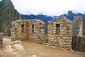
Machu Picchu |
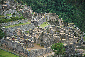
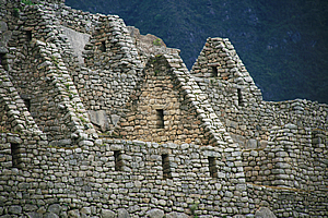
The city itself was covered in bright yellow green grass filling the spaces between the grey terraces of the western agricultural area and the building structures. Some of the buildings were complete with only the thatched roofing missing. Other buildings lay in various states of ruin.
I was surprised to see the excellent condition of the city as it had been completely smothered in jungle when Hiram Bingham discovered the ruins in 1911.
Behind the city, on the other side of the river stood the jutting purple peaks of the jagged mountains standing some four kilometres high above sea level. To our right was a solitary small building complete with thatched roofing. This was the Recinto del Guardian – the Guardhouse. No doubt a guard would have been posted here five hundred years ago to watch for people approaching along the trail.
There was a strong spiritual presence here. It had not been inhabited for over five hundred years, but I felt a similar spiritual presence here as I had at Angkor Wat about a year ago. There was something very reverend about this place, especially as we had been on a pilgrimage through the mountains over the past four days to get here. That brought the whole experience to a totally new level. I wondered if they tourists who had come up here by train would have that same feeling as those of us who had done the track? Probably not. Doing the track had given us the time to experience the Incan ways and to built up to this climatic moment. Taking the train here would have been like flying a helicopter over a mountain rather than have actually gone and achieved it.
Here I was standing at the place where the Incan emperor would have first seen his destination at his retreat about a hundred and twenty kilometres from his home in Cuzco. This was a very remote outpost – so remote that the Spanish Inquisition never discovered it.
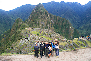
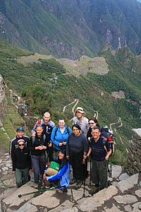
My group at Machu Picchu |
We had a couple of group shots, before setting off down the hill towards the entrance gate where we will need to pick up our tickets.
We followed Wilbur down towards the entrance gate to get our tickets. I would have thought this would have been arranged at the gate at Winaywayna. Not so apparently.
We were just getting off the top of the viewing platform when Amy suddenly dropped her SLR camera. It landed with quite a bang. Amazingly it didn’t shatter. She quickly picked it up and tried it and all was well. It was still taking good photos and there was no damage to the lens. She said there was nothing to worry about because she had dropped it several times so far on her trip around the world.
Now that was intriguing as she had the same model camera as me. I had never dropped my camera before despite taking it travelling in all sorts of outdoor locations totally unsuitable for any electronic equipment. I had taken over fifty thousand shots with it to date and still it was in very good condition. It was kind of nice to know that it could survive a fall onto hard rock like this. Not that I was at all willing to put that to the test.
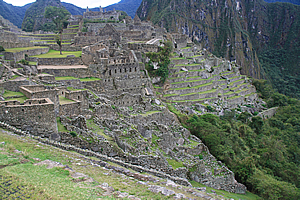
We followed a narrow path through the top of the city down from terrace to terrace. Although the top of each terrace was flat following the contours of the mountain, the drop from the terraces was precarious at over fifty degrees. This would have been an extremely difficult city to build so far away from anywhere.
Machu Picchu |
The echoes of the river thundering below us reverberated amongst the precipitous mountains as we approached the crest of the ridge and continued heading downhill. We passed an interesting natural rock from where a lot of people were getting photos taken. This must be the “other” picture perfect photo location. We continued down a path passing a few stone huts that would have served as houses. Finally we reached the new looking wooden entrance building. It was painted a dull khaki green no doubt to blend in with the surrounding scrub.
Once through the entrance we waited on a platform above the road where buses were dropping off tourists. It felt strange to be in such a crowded environment with so many non-exploring tourists without having the experience of the trail all waiting with us. I supposed the one thing they had on their side was that they were a lot cleaner than us hikers who hadn’t washed properly for three days.
We approached the entrance gate, and Wilbur showed them our passes. They gave us a map and a ticket each and let us through. My ticket number was 711750. Now we were officially in the city.
Marissa and Amanda hurried across the city to Waynapicchu to climb the steep hill as Wilbur led the rest of us back into the city going past the grain storage houses.
Wilbur led us along a grassy terrace across the rows of huge stone retaining walls down the slope of the hill. The terrace was very flat, and I’m sure they would have worked out what species of vegetable grew best in each part of the terrace that we walked upon. Studies have shown though that the areas reserved for horticulture were not sufficient to have supported the population there.
Machu Picchu from near the entrance |
We reached the end of the terrace near the bottom of the east agricultural sector and climbed down to another level where we all sat down to listen to Wilbur explain the history of the city of Machu Picchu. We crossed our fingers hoping he wouldn’t do his rain dance, and thankfully it didn’t rain. Just above him was a short row of large bromeliads, the only ones in the entire city. From here there was a great view across the Group of the Three Doorways.
The ruins along the top of the ridge were intact and well maintained, but I noticed the further down the slope I looked, the more derelict the rubble was. Towards the bottom the terrace walls were no more than jumbled piles of rock interspersed amongst the bright green grass at the edge of the forest further below. Some of the rubble had planks of wood across them to assist any archaeologists exploring the area. It was as if the rubble was supposed to merge into the chaos of the forest below.
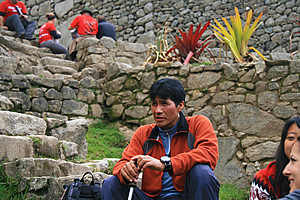
Wilbur talks about the city |
The city had been established as a religious retreat for the wealthy Incan emperor. It had taken fifty years to build. A hundred years later in 1572 the city was abandoned. Although the Spanish had never discovered it during their conquest, it is believed most of the inhabitants died from smallpox introduced by the invaders and carried by people who still travelled here. It remained hidden from the Spanish despite being just eighty kilometres from the capital city Cusco.
Ruins of Machu Picchu |
It lay in ruins with the forest gradually taking over it like the forests had overtaken the temples in Cambodia. Finally in 1916 it was rediscovered, and after many years of preservation effort, it had largely been restored for us and many other tourists to enjoy now.
The city was divided into two main areas, there was the commercial and religious area where we were exploring. Further below in the other section close to the monolithic mountain of Waynapicchu was the residential area.
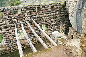
Fountain |
Ruins of Machu Picchu |
The movement of the big stones was a mystery. The wheel wasn’t used in their culture apart from on children’s toys. The lack of strong beasts of burden coupled with the steep terrain would have rendered the wheel impractical.
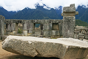
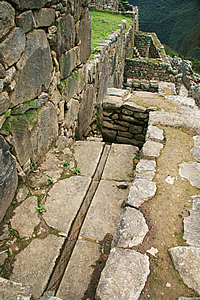
The city contains at least one hundred structures and a hundred flights of stairs and many fountains. The stairs, fountains and the foundations of many of these buildings were carved directly into the solid granite.
Wilbur successfully completed his presentation without any rain falling. I noticed though the clouds were starting to descend. The higher peaks that had been visible earlier this morning were now enshrouded with tufts of cloud.
Perfect complex construction |
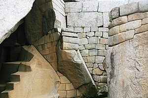
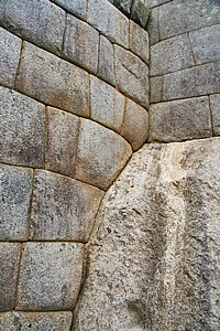
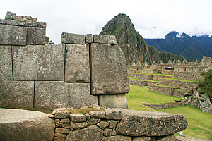
We climbed up to the temple area of the city. The temples were built from the most perfectly shaped stones. There were some huge boulders there that formed part of the natural landscape. All the surrounding stones were perfectly cut to fit around the boulders. There were a few interesting blocks of stone on the terrace. I didn’t know what they were for. Perhaps they were for irrigation, or maybe they were construction blocks that had been dislodged and the archaeologists couldn’t put them back together again.
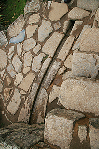
We followed a stone stairway between the stone walls directly uphill towards a round temple known as the Temple of the Sun. On the way up, I passed a small water channel carved perfectly in the rock. It was still carrying a large trickle of water perfectly along the channel as if it were built just yesterday – not five hundred years ago. There were a couple of other water supply channels with a flow of about a litre every two minutes. The irrigation system comes from a single spring considered to have a very strong spiritual significance. This one spring was designed to provide water to every house and building in the city.
Temple of the Sun |
The Temple of the Sun was built on a large strangely shaped boulder. The boulder was larger on top than at the bottom creating an overhanging ledge which the temple stood atop. Underneath the tower was the Royal Tomb which was roped off. There were strange staircase shaped rocks giving it quite an abstractly geometrical look. These rocks formed the symbol of the Pachamama. Inside the tomb were the mummies of the Inca’s ancestors and high imperial dignitaries. The Inca would enter to worship them and offer tributes.
We climbed a stone stairway and entered the temple of the sun. From inside the temple we could see through a trapezoidal window up to the Sungate. The window was positioned exactly to view the sun rising in between the two pillars of the Sungate on exactly the spring and autumn equinoxes. From the temple the priests were also able to work out the summer and winter solstices, and also when the midday sun passed vertically overhead as we were in the tropics. It was all very cleverly done especially with the Sungate being a couple of kilometres away. Their sense of astronomy was amazing like many other primitive cultures who built temples.
Perfect stonework |
Perfect stonework |
In the middle of the temple, the rock had been cut flat apart from a stone altar carved into the same rock that held the temple. No doubt this was used for religious purposes.
There was something very religious about this place. The people who had built this city, and who had briefly lived there must have been very spiritual and in close fellowship with nature characteristic of adherents to the animistic religions.
Next to the Temple of the Sun was the Palace of the Princess, believed to have been used as a special retreat for virgins to be sacrificed to the sun, or who would have otherwise taken part in religious rituals.
Upon leaving the Temple of the Sun, we climbed further along the narrow stairway streets resembling those of Cuzco, passing under perfectly constructed doorways resembling those in Egyptian tombs. This was part of the Temple of the Three Windows. There were stone figures representing the three levels of the Andean World – the Hanan-Pacha (the sky, or spirituality), the Kay-Pacha (surface of the world, or materialism) and the Ukju-Pacha (the underworld, or inner life).
Temple stonework |
The walls around the obvious temples were even more perfect than brickwork, whereas the construction of the lesser buildings was somewhat more rustic with irregular rocks still perfectly joined together. Looking up the mountain, the grassy tops of the terraces were hidden from view, so it appeared to be one continuous rock wall as viewed from here. The ground was covered in compressed sand. I’m not sure whether it had been cobbled and worn out from the tourist traffic, or whether it had always been covered in compressed sand.
Houses perched on the saddle |
We reached an area with steep gabled roofing again, probably the emperor’s residence, along with the residences of the Amautas (the wise people), and the Nustas (the princesses). There was another fountain with a perfectly formed running water spring carved into the rock.
Once through there we began to ascend to a higher temple area – this was the Main Temple. Now for the first time we had a view over the Central Plaza, a large low area covered in grass with no buildings at all. On the other side was a low ridge with a lot of houses on it. This was the main residential area.
We followed the narrow track climbing towards the Main Temple. There where more houses perched on the slope below us. To our left was the quarry, where a jumble of huge boulders had been carved out of the solid rock but never used for the construction.
The track steepened as we continued heading up to the Main Temple. Some of the stone walls had moved with some of the blocks falling out or at least showing gaps where they should be pushed in. This had been caused by centuries of water seepage. It is not known which god this temple was used to worship, but historians believe it would have been the invisible chief Andean god Wiraqocha.
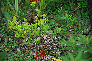
Coca plant |
We stopped at one point where Wilbur pointed out a Coca plant – Erythroxylon Coca, a small bright leafy shrub. This was the plant where Coca Cola and cocaine and various chocolates was made from.
Finally we reached the top of the Intihuatana Pyramid, containing a large courtyard and various temples.
In the middle of the courtyard was another large stone set up as a huge compass. This was known as the Intihuatana Stone. It has been arranged to point directly to the sun during the winter solstice. The name literally means the hitching place of the sun. The Inca believe the stone holds the sun in its place in the sky. It is noted the sun casts no shadow when directly overhead at midday on 11 November and 30 January each year. It casts a long shadow on the southern side on 21 June, and a shorter shadow on the northern side on 21 December. It is therefore used as a calendar.
Temple altar |
Then there was a large boulder set up as a table. There were other large temple buildings of significance.
From here there are four mountain peaks at precisely the four cardinal points. The summit of Machu Picchu mountain is to one direction, the mountain behind the Sungate is in another, and there are two other mountains whose summits are in the other two directions. Between them these mountains point exactly to north, south, east and west.
Compass stone |
I also had a good view down the river, to where a small power station stood. That would explain the pylons passing the campsite yesterday, and following the track back on our first day.
I thought we were at the top of the hill, but there was another rise of a good twenty metres to go. We followed the narrow trail up to the very top to where we saw more temples.
From the top, there was a spectacular view back to the main city terraces up to the viewpoint where we had arrived, and up to the top of Machu Picchu Mountain. The mountain looked quite big now, totally different to the tiny mountain we had seen far below us this time yesterday.
Looking back over the city from the temple |
There was one upturned stone with a jagged edge that exactly matched a mountain on the other side of the river. Although the cloud had by now descended to below the jagged tops and we could not see this peak any more.
I took a photo back over the city towards the top of the mountain just as Luis and Carlos climbed up in front of me. They were both too low to be in my field of view, so they joked telling me they were down here. Very funny I thought as I photographed them laughing. I’m sure it was just a joke.
"We are down here!" |
From here we also had a clear view down to the residential sector. Wilbur did another presentation, this time referring to the map to jog his memory. There was another irregular shaped block of rock used for religious purposes no doubt.
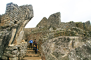
We walked out of the top of the temple and saw a man with a surveying tripod, no doubt taking accurate measurements of the city as part of an archaeological expedition. I’m sure it would have been very difficult to work here with so many tourists around. We then followed the stairs naturally placed perfectly in between the giant boulders that held up the temple.
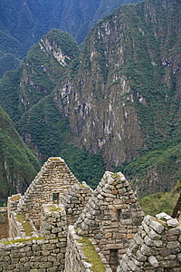
Precipitous sides of the city |
When we reached the large terrace at the bottom of the temple, we stopped and Wilbur said this was the end of the tour. We were free to explore the rest of the city as we wished. There was a large flat area below us, and beyond that was a wall holding up the next level on the other side. This side contained all the residential houses. It was like a compact townhouse complex extending along the side of the mountain. By townhouse complex standards it was very long. It could have been any ancient townhouse complex but the one distinguishing factor was it was up here on the saddle of such a precipitous mountain. That made it incredibly impressive. At the left end of the residential area was a couple of large A framed huts at the entrance to Huana Picchu. On either side of the terrace was a sheer drop into the river.
We briefly rested under the huge boulder before Wilbur let us all go to start exploring at will – even though we really had very little energy left after our four day pilrimage along the Inca Trail.
I crossed the large lower terrace between the two sections of the city. The walls of the terraces here were in straight lines and perpendicular where needed. They still followed the contours, but in rectangular sections. There were a few wooden staircases set up in some of the corners as there were no stairs constructed by the Inca.
Terraces of the common area |
I worked my way towards the two large A framed huts at the entrance to Waynapicchu. A small wooden fence with thatching on top blocked off the sacred mountain area. I wondered where the girls were now, whether they had reached the top. Shame they hadn’t had the time to explore the city.
About half way up the face of the sheer rock face was a cave. This cave contained the temple of the moon. It was an elusive compliment to the temple of the sun.
Entrance to Waynapicchu |
I explored the large A frame huts which were open picnic areas before heading over a very rough cut track over the partially carved stones towards the residential area. This track was a lot more natural than anything I had walked on over the entire trail. At the top of the track was a natural flat rock from where I had a view of Waynapicchu mountain without any buildings in the view. It looked just as it would have when the Incan emperor was exploring this site to build his amazing retreat.
From there I walked through the Residential District, otherwise known as the Popular District. I looked in all the small townhouses where the farmers and servants lived. Some of these houses had spectacular views of the mountains being at the edge of the hill. The houses were all very close together and were now devoid of the thatched roofing that had protected the residents from the elements.
Waynapicchu |
The buildings were mostly in very good condition, but there were still big piles of rock rubble lying around on the grass inside the unroofed buildings. The windows to these houses were small and wider at the bottom than at the top in the same fashion as the houses in the lower part of Winay Wayna. Like the temples in the other part of the city, the houses were built perfectly around the huge boulders that had originally occupied the area when it was first constructed. The residential area was rather like a very compact townhouse development now so common in cities around the world. Of course the walls of modern townhouse complexes wouldn’t have anywhere near the strength as the half metre thick walls of this village.
Residential houses |
There the workers who maintained the emperor’s retreat city. They maintained and worshipped in the temples as per the Incan religion. They also tendered the fields, but archaeologists have calculated the agricultural areas here would not have been sufficient to have fed the people here. They must have imported a lot of their food from the farms further along the Inca trail, and no doubt much of it had to be brought in from the farms between Ollantaytambo and Cuzco.
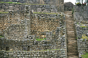
Stairs climbing the walls |
There was nothing particularly special through here, apart from the views out to the mountains on one side and to the rest of the city out to the other. There was one area known as the group of the three doorways – a very significant area culturally but not standing out as did the temples of the other side of the city. As I looked down the formidable hill immediately beyond the houses, the further down the more ruined the city became until the terrace walls were no more than piles of rubble.
Overhanging house |
One house stood on an overhanging rock solidly planted into the ground. The rock came back at about a fifty degree angle putting about half of the house on an overhang. There were a couple more houses below this one, then the steep cliff drop to the river thundering far below.
As I started to approach the end of the village, I could see the amazing geometry that covered the entire city. This would have been designed and built by very intelligent people who would have seen the small saddle atop the precipitous mountains in the jungle and had somehow visualised the amazing retreat that it would become. Planning and undertaking such a project would have been very daunting.
Temple on an overhang |
I passed another stone building perched atop another overhanging rock, but this one stood several metres above the rest of the village. It would have been a scary place to have been during a storm. This was the temple of the condor, containing an altar shaped like a condor’s head. Under the temple was another burial area with strange shaped carved stone shapes no doubt used in the preparation of the corpses for burial.
I then passed a prison. The jail cells were set into the ground. They did not have any roofing, so I could see the cells below and the maze of underground dungeons linking them. It was hard to believe though such a tranquil retreat would have any need for any jail.
Prison |
I reached the end of the residential area and crossed over the main square, which no doubt would have been used as markets. I returned up through the main temples, seeing more working irrigation channels.
Finally I reached an area of the city where three of the buildings actually had thatching on the roofs. I entered two of these, having just caught up with Amy, Hannah and Kathleen, so we explored them together.
The buildings were rather small and claustrophobic, each containing a single four by seven metre room with a high gabled ceiling. They were quite dark inside, and I imagined they would have been darker still with doors installed. That is if there were doors at all. They would have been used as the storage buildings for the supplies that had to be carried in to supplement what they grew here.
Looking back to the main view point |
Perfectly preserved irrigation system |
The roofing consisted of fairly thin logs following the direction of the gables at either end peaking along the ridge of the roof. Horizontal cross members held the logs in place in a solid triangular shape. Above the logs were thinner log rafters which held up the thick brush thatching.
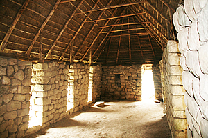
House with a thatched timber roof |
The others walked out to a nearby terrace to rest. I still had some energy left, so I walked up towards the top to get some more shots. I reached the big flat rock and took a few photos. I noticed now the cloud had dropped quite significantly so the clear view of the jagged mountains in the backdrop was no longer there. Drat, I should have gotten this shot on the way down from the top earlier when the cloud was clear of the peaks.
Otherwise the view was amazing, with getting more of the residential area than at the main viewing platform. Though being high up didn’t really capture the steepness of the terrain as had the shots from within the village.
Houses |
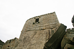
Then I continued up the steep stairway towards the guard house at the top standing in solitude above the rest of the city. The building was locked and seemed to have a lot of people around it. From there looking through the mountains upstream thick clouds were bringing dark rain that obscured the steep slopes. It looked like it was going to be raining here within the hour, so it was time to start making tracks.
I walked back to the viewing platform, to take a few more shots of the city with the small mountains still forming a great backdrop behind it, and of course the brightly tussled Llamas feeding up there. Exhausted, I headed down to where the girls were still resting. We took a few photos as the cloud quickly descended before returning towards the entrance building.
It was time to meet the rest of the group so we reached the entrance only to find a very long queue for the buses to the bottom of the hill. It went down the steps then snaked its way around to the bus stop and there weren’t many buses around. Most of the other tourists there were middle aged to elderly fresh and clean and a bit unfit. In stark contrast were us who haven’t washed ourselves properly in the past four days having hiked the length of a full marathon over very mountainous country. We hadn’t noticed ourselves looking increasingly ragged, but now against these other tourists we stood out like sore thumbs.
A bus arrived and we managed to advance a little up the queue. Behind us the queue was getting longer faster than the buses were able to shorten it.
Finally we reached the front off the queue, and a bus arrived. We climbed on board with Amy sitting next to me and away we went.
Aguas Calinentes |
The bus slowly descended the hill, going across the steep slope going around hairpin bend after hairpin bend in the bromeliad and moss covered gnarly cloud forest. We passed precariously close to a couple of other buses going the opposite direction up the hill to pick up more tourists.
Finally we reached the bottom and crossed a narrow one lane steel bridge over the cascading Urubamba River brown with heavy rainfall at a low two thousand metres above sea level. The air felt so thick down here after spending nearly a week at high altitude. Then I realised it will be another week before I will drop below this altitude again. From here we were heading up towards three and a half thousand metres tonight, and remaining at over three thousand metres until I fly to Chile in about a week’s time.
Once across the river the bus followed a gravel road along the bottom of the narrow valley. There was hardly any room yet there was also a railway line. Precipitous cliffs towered impossibly high above us echoing the roaring river loud enough to hear even from inside the enclosed bus. It was already hard to believe that just this morning we were hiking high up in amongst these precipitous obelisks.
Bridge into town |
The bus rode around the bottom of the gorge until we suddenly saw ahead of us a town perched against the edge of the thundering river come out of nowhere. The brown water pounded over the huge white granite boulders carving its way downward into the steep mountain. Clearly glaciers have never been here before.
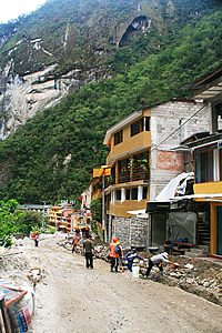
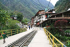
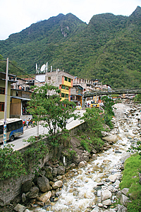
The bus dropped us off in the middle of the small town of Aguas Calientes, with two storey buildings lined up on either side of curved paved streets at the bottom of the precipitous mountains. The mountains stood so steep and high, they looked as if they would collapse at any time. The road had railway lines in the middle of it with small trains shunting along it and small carts negotiating between them. The street was otherwise paved, but most of the paving was getting dug up and replaced. Obviously they don’t make paving here like they used to back in the Incan times.
We walked along one of the streets until we reached a small pizza place opposite the Banko de la Nacion (a bank) where Luis and a couple of the others had already arrived. We walked up to the upper level, but decided to return to the ground level and get the big table near the front entrance. It will make us easier to find anyway.
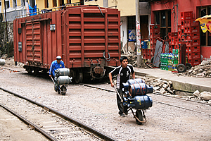
Locals delivering gas bottles |
We sat down at a table at the front of the charming brightly coloured restaurant and ordered pizza.
Everyone else arrived in dribs and drabs thanks to the regular bus service, with Marissa arriving last having been a bit confused with whether to get the bus or wait for us. We all ordered rather unhealthy pizza and ate it for lunch. The others seemed to like such unhealthy food a lot. I had hoped for something a bit more nutritious following four days of hiking. At least this was a lot better and faster than the one we had at Ollantaytambo the night before we started the hike.
As we ate the occasional small single carriage train passed outside on its way to the final station at Machu Picchu. A couple of small men passed wheeling four large gas bottles each in wheelbarrows. A small dump truck went past with four road workers standing in the dump tray. Then a large blue train slowly went past. This was a first class carriage said Luis, where tourists pay over five hundred dollars to travel in luxury.
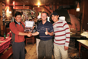
Receiving my certificate from Wilbur and Carlos |
Once we finished eating, Wilbur and Carlos appeared and presented each of us with a certificate of achievement. I had my photo taken with them to add to the one Ryan had presented of my climb of Mount Kinabalu earlier this year.
Following the presentations, we had a walk around the charming village. I walked back downstream to where I got a very nice view of the river. The floods at the beginning of the year had caused a lot of damage here and part of the road was still washed out. In January sudden flash floods had severely damaged the railway and some of the roads (hence the resurfacing of cobblestones outside the restaurant) and had left over two thousand people stranded. The tourists in the area had to be evacuated by helicopter.
The river must have flowed incredibly fast during the floods. Today the water level would have been a bit above normal, but it was tumbling very swiftly over the giant boulders. There must be a lot of uplift going on here for such a big river to be running so swiftly between such high vertical cliffs on either side.
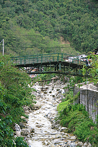
Bridge between two markets |
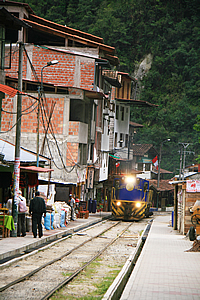
Train passing through town |
I returned to the village and continued following the main road crossing a couple of large streams which tumbled down large rocky steep riverbeds with large stone retaining walls on either side holding up buildings. This was what I would have expected for a village perhaps somewhere in the depths of Switzerland.
Stream rushing through town |
Aguas Calientes would get very little sunlight at any time of year thanks to the precipitous mountains in all directions around the gorge, and due to all the cloud here. Thankfully we were well in the tropics, so it would never get too cold here like it does in similar places I’ve been to in New Zealand in the South Island.
As I continued walking up the road, a train slowly approached from behind. The road was quite narrow, so I had to go right over to one side as the train passed. Then I realised I was at the edge of a large market place. I quickly walked through it not expecting to buy anything. The markets mostly sold brightly coloured alpaca clothing. The market followed the side of one of the big streams. I reached the end of the market and crossed a footbridge across the stream and walked down the other side to an alley way that led into a small square with a few statues of early settlers here.
There I met Michael and Julia who were also out for a walk. We returned to the restaurant and collected our bags to walk across town to catch the train.
Luis led us to the train station, where we climbed into a rather colonial looking train carriage. We took our seats in the silver grey cabin. There were large windows on either side of us and more windows along the top of the carriage. I had only ever seen windows along the roof of a carriage before, and that was on the bus I took to Milford Sound back in New Zealand a few years ago. The bus had the windows along the roof as the mountains we passed were so high and steep that you had to look directly up. It was the same case here.
The train pulled out from the station to commence a very slow journey following the Urubamba River upstream towards Ollantaytambo. We passed through spectacular country as we followed the bottom of the gorge past the river. The forest was thick, but in most places it was clear enough to see the precipitous bluffs rising kilometres high into the sky above us. We passed through numerous tunnels. The terrain here was incredibly rough. No wonder they had built the trail to Machu Picchu over the three mountain passes.
Amy was sitting next to me, but quickly fell asleep. She had done by far the biggest hike in her life which much later in Facebook Chat she would tell me it had nearly killed her. As she slept, Derek reached over and grabbed her small yellow camera sitting on the table in front of her. She had used for most of her happy snap shots during the trip saving the SLR for scenery. Derek took several shots of her sleeping. We then took a bet to see how many days it would take for her to discover those shots.
Like me, Amy had two cameras. The little yellow camera was used for happy snaps, and the SLR was used for the good shots. This was good risk management because if either camera was lost, stolen or damaged (as the big SLR very nearly could have been when she dropped it at the top of Machu Picchu), then she would still have her photos from the other camera.
Once the fun was over, Derek pulled his trademark hat over his face and slumped over to sleep whilst Avani continued sipping on her coke. Everyone in our group was exhausted after the four day hike. With everyone snoozing, I looked out the window at the amazing view – nice to now see the scenery passing us without having to walk.
The cliffs were actually too steep to get much of a view, not to mention the forest we were passing through and frequent tunnels. We passed a rather crude train station where a few people had some produce to load onto a freight train. Goodness knows where they came from. When we did cross a precipitous stream, I could see the mountaintops now enshrouded in misty cloud.
The valley suddenly widened and I saw the precipitous needle like peaks surrounding the valley cocooned in mist. We crossed over the top of a small lake stained almost black with tannin. This was quickly followed by a very small area of Incan terraces covering about an acre. Shortly afterwards the cabin attendant came and gave each of us all a small box of dry nuts.
Then the cloud suddenly cleared and I could see the glaciers near the top of Mount Veronica. The white snow highlighted against the black rock. Vertical needle peaks surrounded the ice in all sides. Then the cloud suddenly enveloped the tops again before clearing once more.
At this stage the forest suddenly gave way to barren grassland. We were surrounded by snow covered mountains rising over three kilometres above us to five or six kilometres above sea level. Shortly afterwards I saw the large ruin of Pallacta which we had seen on the first day from the hill we had climbed. It looked a lot different from down here. It didn’t have anywhere near the grandeur that we had seen from the top. The people who had taken the train in both directions had no idea of the amazing ruins we had seen from the trail. They had not had the chance to experience the journey as the Inca had experienced it.
A few minutes later we passed the swingbridge marking the start of the trail. From here the train continued for another ten minutes following a similar route we had done in the van up to the start of the trail until reaching Ollantaytambo. There was a funny sign on the window telling us not to put any part of our bodies out the window. It read “No sacar la cazeba ni brazos por las ventanas – Not remove the head or arms through the windows”. That could easily have been interpreted as “do not use the windows to decapitate yourself”. Decapitation certainly wasn’t on my agenda.
Looking out, I could now see the jagged peaks and glacial fields so enormously high that it seemed the entire Earth curved upwards rather than downwards as you would expect in a spherical world. It seemed the world here was inside out, perhaps like a super cavern seen in a journey to the centre of the Earth. The misty clouds were clearing, but still rising in the craggy gullies like a hellish smoke.
The sun was setting and the sky was quickly darkening as the train slowed to arrive at the Ollantaytambo station. Here we left the train as the sky grew dark. We walked a short distance through the very crowded street to the main market area I had been through several times. There were numerous hawkers with hand written signs on pieces of paper advertising their hostels and tour groups in the hope of getting their rooms filled tonight – no doubt at extortionate prices.
We called into the tiny supermarket and bought some junk food for the bus ride back to Cuzco. It was a bit tragic after having eaten so well on the trail only to resort to junk food and laziness. No doubt that would be a bit of a shock to our bodies.
It was totally dark by the time we left the shop. There was no chance now of photographing the amazing scenery on the way back to Cuzco.
We climbed onto the large bus. Some of the others had alcoholic beverages which they were pouring out into glasses and giving to each other. I had coke – dreadful stuff, but this was the land of the coca plant, and I had even seen one today, so why not? In hindsight though I should have bought the local Inca Cola as it was much nicer and produced locally.
The driver climbed into the bus and started driving us along the road in the total darkness. We started partying rather noisily.
When we reached the town at the bottom of the valley just before the long climb towards the highlands, we stopped. Luis pulled out a coke bottle and spoke into it as if it were a microphone telling us that we had to change buses here. Perhaps another group back in Ollantaytambo needed the big bus more than we did.
We walked thirty metres up the road to the large minivan and climbed on board, carrying all our stuff with us. Once settled into the much more cramped conditions, we started the long climb up the hill out of the Sacred Valley heading back towards Cuzco. We spent most of the way back singing silly songs totally out of tune and out of time and doing Mexican waves. Such was the jovial atmosphere of having successfully completed the Inca trail.
| Home | Photography | Diary | Travels | Treks | |
© 2001-2020 walkaboutjeff.com - Copyright - Disclaimer - Who is Walkabout Jeff? |