|
||||||||||||||||||||||||||||||||||||||||||||||||||||||||||||||||||||||||||||||||||||||||||||||||||||||||
|
||||||||||||||||||||||||||||||||||||||||||||||||||||||||||||||||||||||||||||||||||||||||||||||||||||||||
Home > Treks > Outside Australasia > Mount Kinabalu > 3 |
||||||||||||||||||||||||||||||||||||||||||||||||||||||||||||||||||||||||||||||||||||||||||||||||||||||||
|
||||||||||||||||||||||||||||||||||||||||||||||||||||||||||||||||||||||||||||||||||||||||||||||||||||||||
Introduction to today's journeyThe only way to discover the limits of the possible is to go beyond them into the impossible. - Arthur C Clarke. Today's trek starts at the bottom of the track around 1700 metres above sea level and steeply climbs a stairway through changing bush until eventually reaching the Laban Rata lodge two thirds of the way up the mountain. Here we stay the night before our summit attempt. Today's JourneyDistance trekked today: 6.2 kilometres. Total distance trekked to date: 9.2 kilometres. Today's JourneyIT WAS quite cold when I woke up in the morning. Everyone else was still asleep, so I quickly got dressed and quietly slipped outside into the crisp morning air. The sky was clear above me thank goodness. Last night’s heavy rain was already a distant memory.
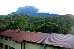
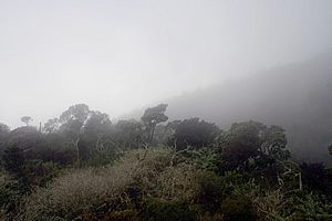
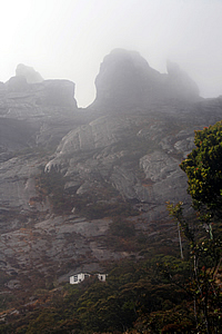
Once off the leaning concrete stairs of the lodge entrance, I walked along the road to a clearing in the forest above the maroon red roof of our lodge. The mountain was standing tall in all its glory. I could see all the way to the top. From this angle it appeared very different to the view I had seen from Kiau yesterday. Over there the mountain appeared menacingly steep looming aloof to precipitous heights. From this angle it seemed a lot wider and a bit more walker friendly with a couple of moderately steep forested ridges rising towards the top. The top of the mountain was fairly flat apart from some impossibly steep pinnacles looking quite out of place shrouded by wisps of cloud. A large patch of solid cloud stood behind the pinnacles giving them quite a spiritual feel about them, as if they really were the guardians of the spirits that went up the mountain. The cloud quickly enveloped the peaks as if to hide them from me. I didn’t need to know everything about reaching the top just yet. After all Sapinggi had told us we will conquer this mountain one step at a time. Pelan pelan. Slowly, slowly.
I returned to the bunkroom. The others were starting to get up, so I packed up ready to go. My daypack was ready containing my water bladder filled with water, plenty of warm clothes for the climb, and of course my cameras. The duffle bag Sapinggi had given me for the porters to carry was packed full of spare clothes, my camera battery charger and various adapters. Everything else went into the backpack to stay here at the bottom of the mountain. Once everyone was ready, we took our daypacks and duffel bags to breakfast, reaching a small restaurant across the otherside of the car park from the information centre at the park entrance. The path to the restaurant had stone stairs and very pretty flowering landscaping on either side. The restaurant was open plan with high cathedral ceilings. It was a buffet breakfast and as usual the boys from Old Zealand ate a phenomenal amount of food especially given how skinny they were. Perhaps having a voracious appetite was a Danish trait. Once breakfast was finished, we walked across to the park headquarters. The gear we were giving to the porters was weighed inside the left wing of the building, and we paid the per kilogram amount to the porters. Sapinggi was doing the weighing, and our other guides and porters were sitting around waiting to start the track, probably eying how novice we naïve tourists were.
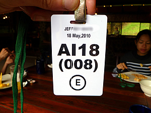
Helping Sapinggi was our assistant guide Lianty, our porter Bambang and two other porters who I had not yet met. Once our gear was weighed we went to a desk in the room to be issued with a plastic pass which we needed to wear on the mountain. It showed our details and the date. Without the pass we won’t be allowed onto the mountain, nor will we be allowed past certain checkpoints along the way to the summit. My pass said “AI18 (008) (E)”. I was member number eight of the party AI18. I assumed “E” meant that I was allowed up to the summit - that's if I survived the climb.
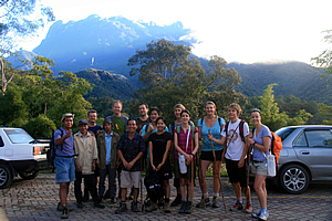
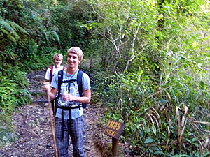
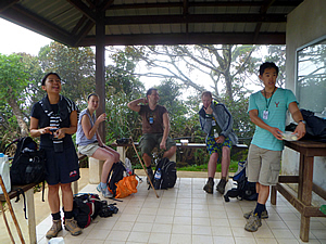
Now that we were all ready, Sapinggi lined us up outside on the car park with the mountain behind us. My camera was taken by one of the porters who photographed the entire group, ready to start the climb. Sapinggi and our other guides plus one of the porters stood in front of us. Being a full head shorter than the rest of us they had to go in front. It was a bit sad that these tiny men would be carrying all our heavy gear up the mountain whilst we would just have day packs. Anyway, they were getting paid to do it and they looked pretty happy about it. Hopefully they will be just as happy on the long climb up to Laban Rata. Anyway we were all keen and ready to go.
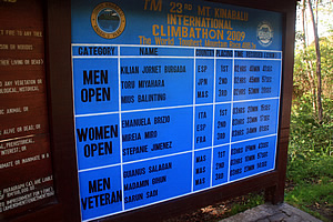
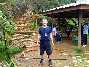
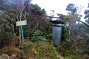
A minibus took us to the start of the track, along a winding road heading uphill through the forest. Once at the car park, we stopped and got out. The early morning air was still crisp and fresh. We walked ten metres to the entrance at the Timpohon Gate at an altitude of 1866 metres above sea level. Beside the gate stood a large sign showing the winners of the last year’s race. The times were amazing. The winner from this year’s race had completed the run from here to the summit and back to the information centre in two hours forty minutes. Obviously we were going to take a lot longer – over twenty four hours at a more leisurely pace. If what Richard told me was true, then it was going to be a quite a slow trip up with some of us looking at all the remarkable plant life up here. I’m sure the people who had run the races earlier this year didn’t even notice the plants during their hustle.
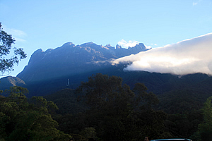
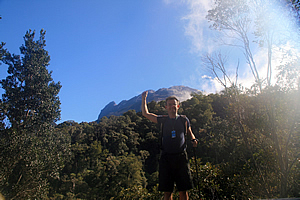
We arrived at the entrance and climbed onto a viewing platform whilst Richard validated our passes at the ticket office below us. From here we posed in front of the mountain. The cloud that had earlier hung around the tops had almost completely cleared by now, but much of the mountain was obscured by forest on the next ridge. The forest looked remarkably like the native forests of New Zealand. We had a clear view of the summit area though. I raised my hand up and asked Jessica to photograph me with my finger touching the summit. She did a good job on that – though I’m not sure if we got the right peak. I think the summit was a bit further over the ridge out of sight.
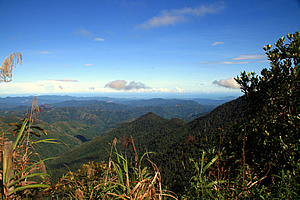
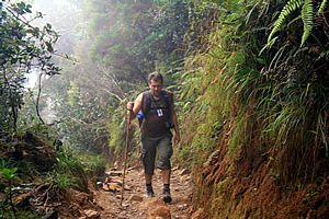
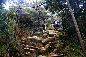
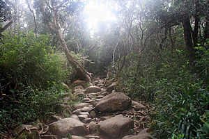
From the lookout I could see down over the mountains we had driven up the other day. All the ridges were at about the same height at nearly the altitude we were. It certainly didn’t seem very mountainous at all down there anymore. We were not yet high enough to see Kota Kinabalu over the mountains. Looking back up at the summit, I saw a couple of small clouds passing over the next ridge briefly cutting out the view giving the summit a mysterious feel about it. Once we had finished the customary "bottom of the mountain" Kodak moment photographing each other, it was time for the business end of things, so we walked through the gate, showing our passes, ready to start the long climb up the mountain. I had anticipated the climb of Kinabalu to immediately commence a very steep ascent up the precipitous terrain. To my surprise though the trail went quite steeply downhill from the end of the building at the park entrance. To me there is nothing worse than going downhill when you are supposed to be ascending to great heights. The descent only lasted for a couple of minutes though as it entered the dense jungle. It was dark in the forest, but I could hear the distinctive hissing sound of a small waterfall nearby. We reached the dark waterfall and from there the track began to go uphill rounding a steep fern covered bluff up some stairs. Lianty the assistant guide led our group, with Sapinggi took up the rear. "Pelan pelan, slowly, slowly", they kept saying. We needed to go up the hill very slowly to conserve energy and acclimatise to the altitude we will be encountering tomorrow in particular. We were heading into high altitudes today, so we needed to go slowly.
The track was no longer steep at all once we were out of the gully past the waterfall. It was a good incline, but it was not long before we stopped to check out how everyone was going. I saw a small sign on the side of the track – KM 0.5, 1935 metres. Richard explained there was a marker like this every five hundred metres along the track all the way to the summit. That was a brilliant idea. I’m the sort of person who sets ultimate goals, but likes to break it up into key milestones. I like to break the milestones into small tasks. Achieving each task works towards achieving a milestone. Achieving each milestone works towards the achievement of the ultimate goal. Today goal for me was to climb higher than I had ever climbed before, to reach an altitude of over 3200 metres. This was far higher than the 2518 metres above sea level I have climbed to in the past. Tomorrow I will be climbing even higher to reach the summit at 4095 metres above sea level. The highest mountains I had seen before yesterday were Mount Cook in New Zealand, at 3754 metres, and from a plane I had seen the 3775 metre high Mount Fuji in the sunset when approaching Narita Airport in Tokyo a couple of years ago. Climbing to 3200 metres today and to 4095 metres tomorrow morning seemed impossible by my standards, yet we were doing it now. That didn’t matter though. I just needed to reduce my goal to achieving each milestone of these small markers at the side of the track every 500 metres. The distances didn’t matter that much. I really didn’t care too much how far away the summit was. Being a climb what was really important was how much altitude I was gaining. Fortunately these markers will say how high I am.
Walking to each marker was essentially the task at hand. Achieving the significant steps of exceeding 2518 metres at my record to date, the hut at 3200 metres, exceeding the heights of Mount Cook and Mount Fuji early tomorrow morning, reaching the summit, then getting back down to the hut were the key milestones. Arriving back at the bottom tomorrow having reached the summit was the ultimate goal. It’s one thing to climb to the top of a mountain, but the mountain is not conquered until you have come back down again. We continued walking along the track, the slope uphill was moderate and comfortable. I commented this to Richard, but he said that it was going to get steep very shortly, and will continue to be steep the whole way up the mountain.
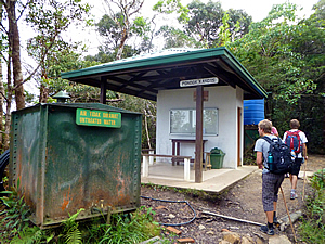
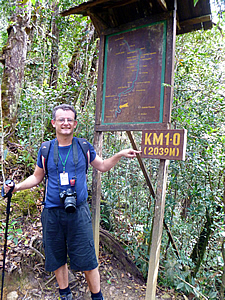
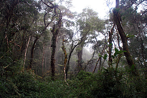
We arrived at the first stop, Pondok Kandis. It was a small white dining gazebo with a flat sloping roof and a single wall at the back, with simple poles at the front holding the roof up. In front of the hut was a large green cube drum about two metres high with the sign “Air tidak dirawat – Untreated Water”. Just past Pondok Kandis was another sign beside the track – KM1.0 (2039M). This was only the fifth time I had been over two thousand metres above sea level – I had done two climbs of both Mount Taranaki (2518m) and Ngauruhoe (2289m) in the North Island of New Zealand. Otherwise I’ve always been below two thousand metres (I don’t count the times that I have been in an aeroplane though). I have always considered two thousand metres to qualify as the start of high altitude, even though high altitude doesn’t officially start until two thousand eight hundred metres. This sign had a large board with a map of the track above it. A small framed roof stood over the carved map protecting it. Sure enough, a couple of minutes passed before I saw the start of a long stairway leading up through the forest. The stairs were quite steep and irregular. By now the forest had changed from dark dense jungle into cloud forest with its characteristic moss covered tree trunks and branches.
We climbed pelan-pelan slowly-slowly one step at a time. Fortunately there were some excellent railings to hang onto. They were constructed of very dark hardwood teak having been erected about thirty years ago. The railings were very crudely constructed though, with a pole sticking up from the ground and the railings haphazardly nailed into the sides of the tops, going off in whatever direction the contours of the path were going – mostly upwards. So many people had pulled themselves up along the rails over the years that they had worn to perfect smoothness – almost polished. Over the thirty years since the railing had been erected, countless thousands of people had rubbed their hands on it to assist with their journeys up the mountain. That was a lot of people, a lot of journeys, and a lot of rubbing. No wonder the rails were so smooth.
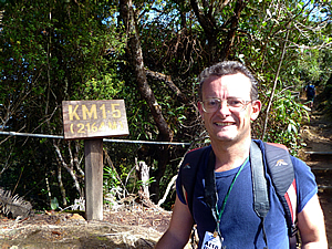
We loosely followed a ridge, passing a small signpost without a map board – KM1.5 (2164M). Here the ridge rose into a bluff we walked around it climbing the steep stairway. Otherwise we walked along the ridge following a fence with five cables fed through black PVC piping to protect them from the elements. By now our group was walking a steady pace. At this point the summit was too far away to even be thinking about it. Pelan pelan. There was no hurry at all, just co Mount Kinabalu is one of the most important biological sites in the world. The mountain has an incredible five to six thousand species of plant, and this doesn’t include countless varieties of mosses or lichen. Within these are over 600 species of fern – 50 are found nowhere else on the planet. There are 800 species of orchid and five of the thirteen known species of Nepenthes carnivorous plant that grow here are found nowhere else on Earth.
This incredible biodiversity spanned across three distinct levels of vegetation. Up to 2000 metres above sea level the lower slopes are covered with fig tree cloud forest with many carnivorous plants. Between 2600 and 3200 metres above sea level is a layer of short conifers, mosses, lichens, shrubs and ferns. Above 3200 metres is the world’s richest collection of orchids. Not only are there many plants, but the animals are spectacular here too. There are 326 species of bird and over a hundred species of mammal on this mountain. There weren’t many visible from the track though. They had strange names like the rhinoceros hornbill, the mountain serpent eagle, dulit frogmouth, eyebrowed jungle flycatcher, bare-headed laughingthrush, and the Bornean spiderhunter, none of which are found anywhere outside the mountain.
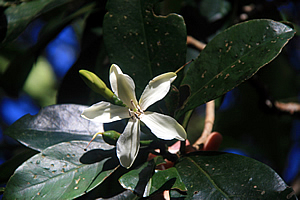
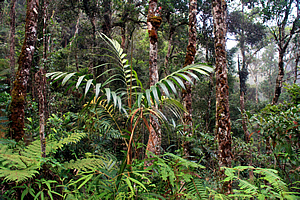
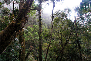
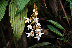
Most of the mammals live high in the trees, including the elusive orang-utan, the man of the forest. They are rarely seen here though. Then there is the endemic Kinabalu giant red leech which preys on the Kinabalu giant earthworm. Those creatures certainly didn’t sound like anything I wanted to encounter. As we climbed higher and higher through the forest, my tour leader Richard pointed out the amazing plants here, the orchids and nepenthes climbing the trees, the ground toadstools and nepenthes growing in amongst the sphagnum moss, the giant king ferns and countless other species covering the ground. Then I realised there was a strange familiarity to this place. I had seen many of these trees before – or at least very similar species. The trees providing the canopy in the cloud forest here were mostly beech trees similar to those in New Zealand. There were also some European trees and even some tree ferns – Cyathea Cooperii. It was as if New Zealand had combined with Europe, but why did this happen here in Borneo of all places? Many trees were covered in epiphytes, mostly by various types of orchid growing matted all over them. The species were too numerous to mention here, but they included the rare slipper orchid found only here on the mountain which I had recognised from yesterday. There were numerous other flowering plants that were unfamiliar species to me.
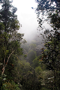
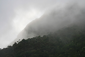
The sky hidden above the thick forest canopy suddenly clouded over. This gave more depth to the eerie forest with the distant trees losing definition in the enveloping fog. Richard explained to me that this mountain is of a lost world containing a remnant of Gondwanaland. Borneo had been joined to Australia and New Zealand during the days of Gondwanaland up to about a hundred million years ago. When the continents had separated the ancient species went with the continents evolving independently. In most areas around this region they had died out as the earth heated. They remained in the cooler cloud forests of New Zealand and Australia though. They had died out over most of Borneo, but on the steep mountain slopes of Kinabalu, they could just move up and down the mountain as the climate changed between the ice ages and the interglacials.
High stable mountains such as this housed lost worlds, and I’m not talking about the small tufts of forest atop each fenglin formation I had seen in Halong Bay that I had imagined last year. This was the real thing. One part of me almost believed there could still be dinosaurs up here, but surely they would have been discovered if that were true. The lost world we were walking through wasn’t at the top of the mountain as most science fiction would have you believe, but instead it was up the side of the mountain, moving up and down when needed to take into account the natural shifts in climate. So long as the mountain stays here, the vegetation will continue to go up and down the mountain as needed, in what Richard said was the second most bio diverse place on Earth.
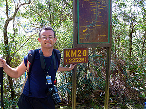
The most bio diverse place on Earth was the Amazon. That is certainly true with the jungle having a higher number of plant and animal species than even here. That being said though, this was a tiny dot on the map compared to the vast Amazon basin, so I would argue that Mount Kinabalu is by far the most bio diverse place on Earth in terms of the number of species per square kilometre. Thankfully this area was fully protected, not like the Amazon which was experiencing phenomenal levels of deforestation like the lowland jungles of Borneo as I would find out in a couple of days’ time. Ahead of us was another small sign with a board above it with a map painted on it. It was good to see we were making progress now. This sign read KM2.0 (2252M). We were now higher than any point in Australia. According to the map we were at a place called Ubah.
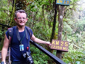
We progressed further into the dense forest continuing our climb fairly quickly up the endless stairway before reaching the next sign. There was no map, but there was an old sign painted in eroded sky blue saying KM2.5 without the altitude almost next to the new sign. I was glad the new signs showed the altitude as that was what really mattered. I didn’t care too much as to how many kilometres we had climbed. What mattered more was what altitude we were at. This sign said KM2.5 (2350M). Now I was higher than Ngauruhoe, and only had a bit further to go before equalling the highest I had ever been. The name of this area was Lowii, named after the first white person to have climbed the mountain and ventured onto the mysterious dome at the top.
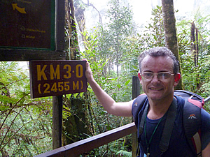
The going became tough climbing the endless stairway up into the sky, but I remembered what Sapinggi had told us. Pelan pelan, one step at a time. I continued following the track until finally reaching another sign – KM3.0 (2455M). This sign had a map above it. The map showed I was now under the RIM station, a large communications tower, though it was unseen above us through the trees. The track continued even steeper but I was in a good rhythm now. Nothing was going to hold me back. A bit further up the track I reached the Kempenging shelter at 2518 metres above sea level. There was a fair bit of work that had recently been done there. There was no railing up here to help us up the stairs anymore.
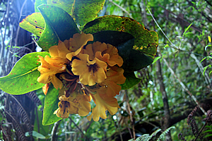
Just beside the shelter was a magnificent bouquet of yellow rhododendron, the most magnificent I have ever seen. As I stopped to admire the bouquet, I realised this was a significant step for me. It reminded me of the amazing rhododendron gardens growing around Mount Taranaki, the mountain under which I had lived my early childhood. To date this was also the highest mountain I had ever climbed, at 2518 metres, exactly the same altitude I was standing at now. It was very different here though. At the top of Mount Taranaki you are faced with steep volcanic scoria with no vegetation for hundreds of metres below you. You are incredibly exposed up there. Here we were still in the dense cloud forest jungle with a long way to climb to above the bush line.
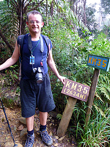
Here I realised if I was to take another step, I would be climbing to new heights. Every step I took from now on will increase the altitude I have ever been. It had actually been quite easy getting up to here despite the eternal set of stairs, so now I started to realise that perhaps I did have what it takes to conquer this mountain. The climb up the mountain continued, all new territory for me, but still we were in thick cloud forest. Some time later I reached another post saying 3.5KM 2634M with an old sign standing beside the new post. Here I was about half way up to Laban Rata – actually well over half way in terms of distance, but about half way in altitude, so there was definitely more steep terrain ahead of us to cover as much altitude in less distance. The cloud was now thick and light drizzle was starting to fall. We suddenly reached a couple of small open air huts and stopped there for lunch. We were at Layang Layang. This is the Dusun word for Place of Swallows – not that there were any swallows here today.
There was a white hut in front of us which was locked, but it had a large balcony with seats around the outside of it and white tiling on the floor. We sat there and unpacked the lunches that the guides had given us at the bottom of the mountain, now a distant memory far below us. There was also a timber hut across the other side of the track to our right where another group of climbers was eating lunch. From where we sat, we could see the track rising steeply up a staircase of boulders with timber beams across it to hold it all together. The forest was thinning out from here on as well. There was a warning sign post at the bottom of the stairs in small writing in Malay and English saying “Notice: Climbers proceeding beyond this point without climbing permits and mountain guide will be prosecuted under park enactment 1998. Park Manager.” Obviously from here on it would be too dangerous to go alone. This is where the real climb starts. Will I be able to make it up to Laban Rata?
We relaxed as we ate lunch. Although my muscles were feeling numb from the exertion to such high altitude, I was coping well. We sat and ate lunch as numerous small squirrels of an indigenous species (Dundasciurus Tenuis) ferreted in and out of the dense foliage. No doubt the population of squirrels was abnormally high around this area with all the bits of food people drop from their lunches. As we ate, numerous porters including Bambang and our other porters passed us carrying all kinds of what seemed to be uncomfortable loads on their backs. Some also had loads in front over their chests. They were all men – no women worked as porters on the mountain so it seemed. It was a difficult hike for them, but that was their occupation, the way they earned money to support their families in the villages at the foot of this magnificent mountain of infinite biodiversity. Once lunch was finished, we climbed the stairs leading out of the small huts through the scrub climbing higher up the mountain through the cocoon of thick cloud. I walked with Geoff, and knowing that he had done the Inca Trail and Mount Kilimanjaro, I asked him how he was going. He said this track was a lot harder than either. Well that sounded encouraging. I was going to be doing the Inca Trail later this year, and this discussion was the seed for setting my sights for doing Mount Kilimanjaro next year for my fortieth birthday.
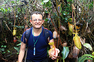
The staircase turned slightly after about a hundred metres before we reached a junction – the first we had seen all day. There are two ways up the mountain. One was the main track which we were following, and the other was the Mesilau trail, which was longer and starting at the information centre we had travelled to yesterday in search of the magnificent Nepenthes Raja. A faded and weathered sign pointed down the trail towards the Mesilau Resort with no indication of distance. The Nepenthes Raja specimens we had seen had the largest pitchers in the world, but they were not the largest plants. Those plants were actually quite small despite their huge pitchers. On our way up the track Richard had told us about a huge Nepenthes Villosa specimen off the track. I was definitely keen to see it, as were Therese, Robert and Jessica.
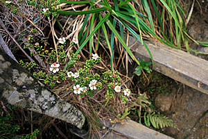
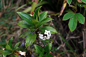
A few metres along the track we suddenly found a very beautiful tiny white orchid in flower. It was very similar to one I had seen on Stewart Island at the bottom of New Zealand about a year earlier. The vegetation up here was a lot scrubbier than it had been previously. We were now in the ultramafic zone. The ultramafic zone is the area between the granite and the surrounding rock it had pushed up against. At the interface minerals had leached out to very high concentrations making the soil very poor for supporting plant life. This explained the sudden change from thick forest to subalpine scrub at the point where we had lunch.
We followed the Mesilau trail about a hundred metres along thankfully level ground before we stopped at a small goat track heading left up the hill. Richard told us there was only enough room at the top for two of us to go up. The ladies were a little uneasy about going first, so Robert and I went first. The rough trail ascended steeply for about five metres before we reached the plant. The Nepenthes Villosa stood a good four metres high climbing the surrounding scrub. It would have been a good three to four metres in diameter. The pitchers were some of the best specimens I had ever seen. They were pale green as they were forming turning a pale lemon yellow before opening. The open ones gradually turned a bright brownish blood red, and absolutely magnificent with their distinctive collared lips. The pitchers that had lived out their days were black around the top. The blackness descended the pitchers gradually over time until they were completely black and dead.
Robert and I took turns posing in an alcove in the plant. It was an amazing experience being inside the world’s largest carnivorous plant. Once we had photographed each other, we returned to the trail and waited as Jessica and Therese went up to the plant. All was deathly silent for a few minutes until we heard the rustling sound of them returning. For a few moments there I thought they had been captured and eaten by the enormous plant. Thankfully they had survived intact. Once we were all back together on the Mesilau track, we returned to the main track to continue our quest up the mountain. They say less than fifteen percent of those who go to Kinabalu actually reach the summit. I suppose many of these people would have no desire at all to attempt the climb, instead being perfectly happy to gaze upwards from the comfort of the bottom. Others attempt the mountain yet do not reach the summit. Most of these people definitely have the physical capacity to conquer it, but as Sapinggi said the other night, physique is of little use if you don't have the mental strength.
The path continuing up the mountain suddenly felt long as we continued walking through the forest which was getting thinner as the ultramafic mineralization increased. This created a zone of heavily stunted vegetation, almost a dead zone. Numerous people walking down the mountain were passing us now, some were beaming that they had made it to the summit. Others just seemed relieved to be getting off the mountain.
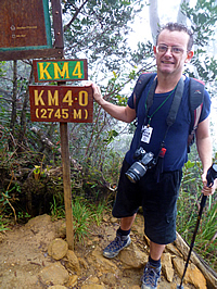
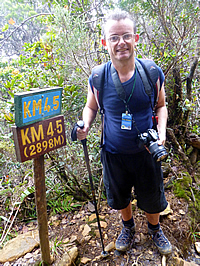
Before long I reached another marker – KM4.5 2898M. I was now one hundred and one metres higher than Mount Ruapehu (Maori for two explosions, a reference to the mountain being an active volcano) – the highest mountain in the North Island of New Zealand, and a little higher than Mount Tapuae-O-Uenuku (Maori for sacred footstool of the gods), the highest mountain in the top half of the South Island. I had not done those mountains before, but already I was higher. The cloud was still very thick here, thick enough to feel the wetness from it. It was now starting to feel a little cold now that we were so high up. The track was now large broken boulders looking as if it were a dried up mountain river bed. The undergrowth was now very thick with a small fern that appeared to be a miniature bracken fern. The forest seemed to be similar to the kanuka forest found near the cost of the top of the South Island. There were many beautiful white and dark pink flowers of all different varieties.
There were more people descending from the hut passing me a lot faster than I was going. Then I suddenly saw a young lady I recognised. I met Jane a couple of days ago in the hotel reception in Kota Kinabalu. She was a young lady from Canada who we had worked out was leaving on a very similar tour to me but departing one day ahead of me. She had shared how much she wanted to climb Mount Kinabalu. I had mentioned I was going up there a day later, so we had agreed to look out for each other as we will no doubt be passing each other somewhere high up on the mountain. She had been so keen, but it was a shame that I wasn’t going to be in the same tour group as her as she had seemed very nice and I certainly wanted nice people in my tour group. Thankfully the group I was with turned out to be very nice.
Jane had followed the trail up to the hut overnight still bursting with enthusiasm. This morning had been a totally different story though. She was too tired to get up and attempt the summit. She said she just didn’t have it in her with the very early morning start. What a shame to have come half way around the world and gone all the way up to the base camp hut only to give up like that. We said good bye, no doubt for the last time we’d ever see each other. I started to wonder if that would happen to me. Is this a symptom of altitude sickness? Most other people we were passing seemed to have happily reached the summit, and some of these people were surprisingly old. The high altitude had obviously not been too much of a mental barrier for them. Maybe there was hope for me. Why is it that some people who you take one look at and decide there is no way they could climb a mountain somehow manage to find it in themselves to reach the summit, and why is it that people who seem incredibly fit fail and say it is too hard? Then I remembered Sapinggi’s words from the other night. It is all in the mind. Sure your body needs to be in good condition for a climb like this. However as he said, ninety percent of the battle is in the mind. Jane obviously didn’t have a strong enough will to conquer this mountain despite appearing to clearly have what it took physically to reach the summit. Now the question was would I be able to make it up? I seemed to have the physical strength having comfortably kept up with the rest of the group, but would I have the mental stamina to climb up there in the early hours of tomorrow morning to the top of a mountain higher than anything I had ever seen before? Only time will tell.
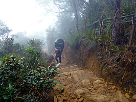
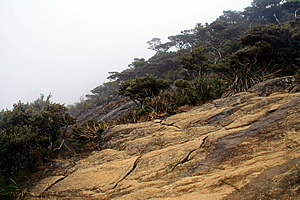
The stunted forest suddenly cleared and the orange soil amongst the rock we were ascending changed into an even stronger shade of orange. The previous area had been ultramafic, but not at all as intense as this zone. The rock here was almost completely bare containing very little vegetation. Perhaps I had reached the tree line. The soil here was too poor to support a forest thanks to the soil being low in phosphates and high in iron and heavy metals poisonous to most plants. The trees here were no more than small windswept gnarly shrubs, similar to some of the bonsai regions I had been hiked through in the subalpine regions of New Zealand. I passed a dwarf lady coming down a steep section making quite good progress lumbering down the mountain with ease. Good on her for climbing such a high mountain! A few minutes later I passed a sign – Tandas – Toilet. A long drop stood leaning to its side about to fall off the mountain about two metres off the track. A thick black plastic tube went over the toilet and continued following the track right up towards Laban Rata hut. Thick cloud swirled around us enveloping the ghoulish hulks of the windswept trees. The stairs gave way to rocks and sometimes large bare granite as we climbed higher and higher. The thick cloud concealed any view to the lower mountains and valleys which would have by now been far below us.
The group had somewhat thinned off, and I was now climbing with Robert. We were both making steady progress, but he decided to rest on a large flat rock sloping with the slope of the mountain to wait for Jessica. With that I was now climbing alone. Just when I had become convinced the forest was about to completely end giving way to true alpine vegetation the ultramafic zone suddenly stopped and thick cloud forest covered me again. The forest was still stunted, the trees here were not standing tall as they had been further below, but they were obviously a lot healthier with better soil to grow in. The track was now rough going over small boulders looking very much like a dry river bed. I imagined that the track would sometimes have a raging torrent running down the track in heavy rain. Fortunately there was almost no rain today, just a heavy mist.
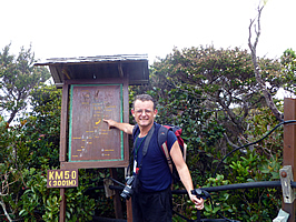
I passed another marker at KM5.0 3001M where Robert and Jessica briefly caught up with me again to take my picture and to continue resting while I continued up the mountain. Now I was over three vertical kilometres above sea level, at the altitude of the highest mountains of the Southern Alps, level with Mount Aspiring. There was now a distinct chill in the air thanks to the high altitude. The temperature is supposed to drop six degrees for every thousand metres of altitude. It should therefore be eighteen degrees cooler here than at sea level. Now I wanted to go up a bit faster to get to the hut as soon as possible. This was too remote a location for hypothermia to set in. Maybe this mountain was too much for me. There is something special about arriving at your destination hut following a long wilderness hike.
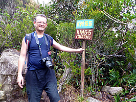
The forest became thicker as I continued rising steeply up the endless stone stairway. The bright orange ultramafic rock and soil had by now given way to hard grey granite. There were a lot of dark green flaxy plants covering the ground. I passed the Pondok Paka shelter where several porters were resting but continued through the forest towards the hut. At the KM5.5 3137 metre mark, I stopped to take another picture of myself. There was no one there, so I made a feeble attempt. Then Jessica appeared and took my picture. Robert was further behind, and had let her go on ahead. I think she was as keen to get to the hut as I was. She asked me how I thought she was going as she had never climbed a mountain before. I mentioned her fitness was very good with doing so well so high above sea level.
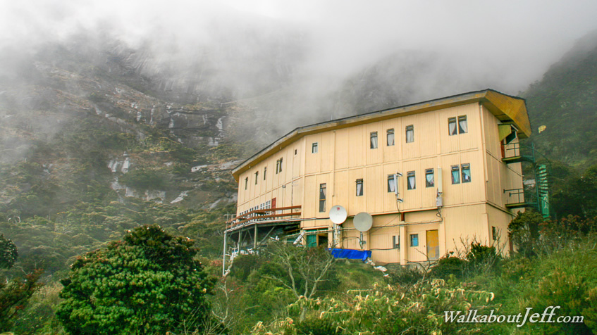
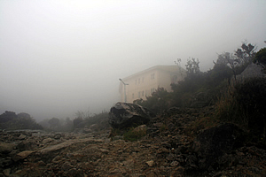
The forest suddenly cleared as the terrain steepened and still the cloud enveloped us, swirling in a chill breeze now. We had long left the equatorial heat of the lowlands. No doubt it was very hot and steamy down at sea level. Large trees were scattered here. Half of them stood dead. The grey exposed trunks and branches against the grey cloud creating a primeval black and white eeriness. Jessica and I walked further until we saw the first of the huts appear in the mist ahead of us. For a brief moment we thought this was Laban Rata, but it was the Warra hut, indicated by a small sign on its long veranda, so we continued walking. Just a couple of minutes later we saw the huge three storey hut of Laban Rata appearing through the thick swirling mist. What a relief to be finally arriving after such a long trek up the mountain.
We continued following the track to around the back of the hut. The narrow end of the building had a spiral staircase which was no doubt the fire exit. Just past the spiral staircase was a tall cyan coloured wooden obelisk saying in vertical letters “Laban Rata”, and underneath in much smaller font – 3272.7M I was very high up. I had only seen two mountains higher than this altitude before from reasonably close – Mounts Cook and Tasman in New Zealand at 3754 and 3498 metres high respectively. This altitude was incredible, nearly fifty percent higher than I had ever climbed before. The landscape immediately around the hut was barren and rocky, with low scrub. A few metres out though and it was all thick scrub with forest growing in the gullies and up the main ridge just visible in the distance through the thick swirling mist.
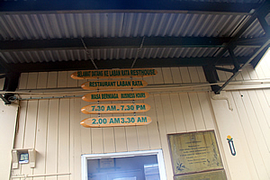
Jessica and I finally reached the somewhat inconspicuous entrance to the hut where a ladder of narrow tree trunk slices above our heads had the following engraved on them
I was horrified that a restaurant way up here in the middle of nowhere would open in the small hours of the morning, but then again that was when most people leave to head up towards the summit for the sunrise.
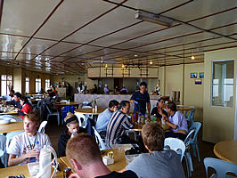
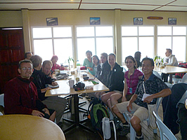
We entered the hut to find several of the group had already arrived, particularly the Danish boys and Suzanne who did not divert to the giant Nepenthes Villosa. I sat down at the table with Richard, Tobias, Casper, Therese, Jessica and Suzanne. They were sitting around a large table by the window, so I joined them for a cup of tea. I suddenly felt a sharp cramp in my lower right leg that froze it to paralysis, but fortunately it only lasted a couple of minutes before easing off. One by one the others arrived, apart from Nadia who had fallen a long way behind. Fortunately she was with Sapinggi. We all mentioned how amazing it would be for her to be hearing all Sapinggi’s amazing stories and being shown all the wildlife as she was slowly making her way up towards us. Laban Rata hut was full of the frenetic activity of climbers who were about to do the summit early tomorrow morning. It was quite crowded, reminding me of the huts in the Abel Tasman National Park back in New Zealand. The tracks had always been relatively quiet during those hikes, but the huts had been very busy full of travellers from all around the world. It was exactly the same here only even busier.
The hut here was different though. The huts in New Zealand were very rustic and coloured to blend in with the surrounding landscape. The walls of this giant hut were painted a warm cream colour and the ceiling was glossy white panelling with florescent tubes powered by the electricity that came up the cables inside the long black ducting that had followed the ridge line the entire way up here. We all sat around simple fold up wooden tables and plastic chairs, each having been brought up the mountain along the track at some stage. Laban Rata hut had been built entirely from materials carried up the track. Today we had seen numerous people taking supplies up, including a gas bottle. A couple of weeks ago a group of six people carried a huge refrigerator unit up to the large restaurant. People worked here. One person yesterday had brought up a washing machine. For such a logistical nightmare in getting anything up here, the hut was very elaborately constructed and decorated.
The hut had three levels. The top level contained the sleeping facilities, the middle level was the restaurant where we were sitting in, and the lower level was the quarters for the guides and porters. The building was extremely well set up as a long rectangular shape with ends bent outwards from the mountain. The reception area to our left had a lady behind the fancy counter serving drinks. There was a doorway past the reception where there would have been offices and perhaps accommodation for the staff. To the right of the building was a row of tables for serving food. Behind that was the kitchen where there was a lot of activity by a group of chefs preparing our dinner. I went upstairs with Richard to our bunk room. The fairly narrow stairs rose from the lower level and doubled back to a long hallway going along the entire length of the buildings. Red stained timber doors provided entrance to each of the bunkrooms apart from one door either side of the stairway going to the bathrooms. The hallway had light coloured wooden floorboards and walls painted a soft cream colour with an orange tinge – nice and warm. There were numerous small murals and urns with sticks in them along the hallway. We reached the first door to the left and entered the bunkroom where our entire group, along with a couple of other groups will be sleeping tonight. My small duffel bag was sitting on the floor against the wall amongst everyone else’s. Thankfully the porters had successfully taken them this far up the mountain. I charged one of the spare batteries to ensure I had plenty of charge up the summit. This was especially crucial as batteries tend to run flat a lot quicker at high altitude mainly due to the lower air temperatures. I put the rest of my stuff, on a spare lower bunk. The bed was made up with sheets and blankets, so it was nice not to have needed to pack a sleeping bag. I returned to the dining hall downstairs just in time to see Nadia arrive with Sapinggi. We had all safely arrived at the hut we will be calling home tonight. We relaxed for a late afternoon tea after having put our gear on our bunk beds upstairs. It was surreal to be so comfortable and well looked after following such a strain up the mountain. The air was abuzz with so many adventurers all together in one place all with a common purpose – to conquer Borneo’s highest mountain. The energy reinvigorated me. The inside of the lodge was very well warmed, but whenever anyone went outside a gust of cold air could come in quickly reminding us that we were over three kilometres above sea level. They say that the temperature drops six degrees for every thousand metres you climb, so here at 3272 metres the temperature was about twenty degrees cooler than at sea level.
The puffy cloud suddenly started dissipating with hints of blue sky showing through, and I went out onto the small balcony through the door beside our table. The balcony was about a metre and a half wide, spanning the length of the building. There were a couple of chairs and small tables out here, but they were all wet. It was bad enough experiencing the cold wind without getting wet as well. The thick swirling cloud danced playfully over the ridges. It was thin enough though for me to see the area was largely bare patches of grey granite rock with trees and shrubs filling in the gaps in the gullies. I heard water running in a nearby gully – obviously the there was a permanent supply of fresh running mountain water for the huts.
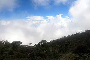
Then the cloud suddenly started to clear. Large patches still stuck to the side of the mountain. The land below was still covered in a thick layer of cloud, with the puffy tops towering to an altitude level with the hut. It was as if I was standing on top of one of the clouds. The sun shone through the deep blue sky. The sky at altitude really is a lot darker than seen at sea level. The top of the mountain ridge was beginning to show through the thin mist. The patches of bare rock glistened from all the water sitting on the surface. That was short lived though. A tower of cloud rapidly approached engulfing the side of the mountain again. With my glorious view across the clouds snatched away from me, I returned inside to the warmth of the hut to join the rest of the group.
Once inside the cloud quickly cleared again, so I went out through the main entrance at the back of the hut. For the first time I could see to the top of the mountain ridge, though the summit was probably concealed behind the ridge that I could see from this angle. From here though, I could see a couple of the precipitous crags at the top. Underneath the ridge, at about three hundred metres above me was the small hut of Sayat Sayat at the bush line. I assumed we were going to be climbing up to there early tomorrow morning. Beyond that though, the mountain seemed very precipitous. Huge vertical towering bluffs devoid of vegetation and overhangs stood over Sayat Sayat hut for hundreds of metres creating what appeared to be a totally impenetrable barrier to the top. Sapinggi and Richard had both mentioned there will be some ropes to climb along, so perhaps they were referring to the towering wall of rock above Sayat Sayat. If so there was no way that I’d be able to climb that. I’m sure Robert wouldn’t climb it either.
From there I left the hut and walked around to the front of it. Not so tired now I could see more detail on the hut with the cloud cleared away. Two satellite dishes hung off the lower storey of the building. Tiny narrow uninviting windows covered the walls at each level everywhere apart from the main dining area which had much larger panes of glass. Imagine having been assigned to carry one of those up the mountain! The scrub surrounding the hut was thick and standing about a metre high. There were no trees around the hut. Several other huts clinging to the side of the mountain rose above the scrub. Perhaps these were private huts or maybe the huts of the workers up here. All the people who worked up here had to walk up the track and stay here for three months before getting a month off and walk back down the mountain and head back to where they were living. They would have to sleep somewhere during their stay.
I had a close look at the shrubs. These were different from anything I had ever seen before, and imagined some of these species were endemic to this area. Mount Kinabalu was a lost world with no terrain like this anywhere on Borneo or for the foreseeable distance in any direction for that matter. There were a few peaks in Papua New Guinea rising over four kilometres high, plus of course the Himalayas on the Asian mainland, but these mountains were all very distant. This mountain was unique along with much of the flora even at this level. Some of the shrubs had small white flowers. Others had pink berries. The cloud had cleared enough so I could see the huge bowl the hut was sitting in. The cloud that translucently covered the top ridges and eerie peaks at the top swirled ferociously almost as a warning challenge against going up. It then registered that perhaps this really was going to be too much for me. After all only twenty percent of people who come to the mountain actually reach the summit. Now I could see why. More cloud suddenly swirled in, and that was the last I would see of the upper mountain before tomorrow morning’s ascent.
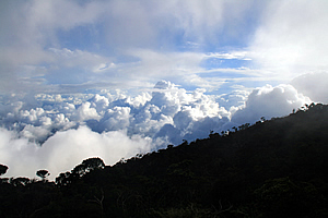
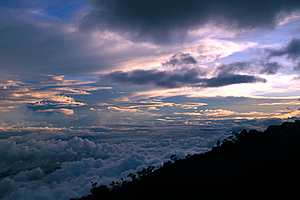
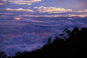
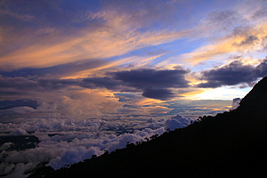
Numb to the bone from the bitterly cold wind, I returned to the group as the cloud thickly descended to envelope us again. The conditions once more looked bleak as rain started falling again. Richard told us that if it is raining in the morning, we won’t be able to go up to the summit. That being said though, he said most afternoons were like this, and he has only ever had one failed trip in all the times he had taken groups up the mountain. I returned to the balcony out the front of the hut where the sky was clear once more, and once more the clouds came up to just below our level brilliantly white in the bright sunlight contrasted against the brilliant royal blue sky and the black ridge in front of me. The sun climbed lower into the sky until it set behind the ridge just as the cloud began to clear again. This time I could see through patches all the way down to the hills over a vertical kilometre below me, and further down into the valleys two vertical kilometres below. Billowing clouds were in between the gaps, but I was above them. It was just like being on an airplane only not confined with the constrictions of looking out of a tiny porthole in the confines of economy class. Here I had the freedom of an unlimited view with my entire field of vision.
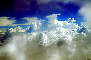
The area down the mountain cleared, revealing the route I had taken up through the forest. Of course the track was concealed by the forest. Far below me stood a communication aerial. From way up here it was tiny. There was a thin layer of cloud above us now, which I recognised as alto stratus. The puffy cumulus clouds were bright rising to just below us, but it was strange seeing the alto stratus mid-level cloud so close, perhaps just a few hundred metres above my head. I was now in the thin clear space between the two layers of cloud with the unnaturally blue sky filling the gaps above the upper layer. The clouds then began to go yellow with the sun fast approaching the horizon. The hills far below began to go dark as the sun had already set down there. Looking up the top of the mountain unveiled itself from the cloud. Perhaps there was hope of fine weather tonight.
Now the mid level cloud had cleared enough to reveal some magnificent cirrus cloud sweeping across the sky seeming very close. The sunset caught on the mid and high level clouds in an amazing orange cream colour contrasting against the purple grey shaded clouds, the bright blue sky and the almost black hills below. The sky quickly darkened as the last bright rays of sunlight stopped illuminating the icy cirrus clouds above. The temperature quickly plummeted so I returned inside the hut to join the rest of the group.
Dinner was finally ready just after the sun had slipped below the horizon. We formed a rather long queue along the serving tables at the far end as the staff dished out some carbohydrate rich food with plenty of meat for us to digest ready for the climb later tonight. The room was abuzz with anticipation. I ate dinner fairly quickly before excusing myself to take a shower. I had a cunning theory to put to the test. Everyone else in the group had taken a shower shortly after arriving, and they all had cold showers thanks to people before them using up all the hot water. Now I’m no plumber but I knew that hot water systems can only take so much capacity, and they take a while to heat up. While everyone would be eating, no one would be showering. I normally wouldn’t mind a cold shower in the equatorial tropics, but not up here where it was far too cold. I went upstairs, collected my towel and took a very nice warm shower. The best part was no one else was here in the bathroom. It was just me. Refreshed, I returned downstairs to join the others. I wasn’t going to mention it, but they asked, and they persisted so I told them the truth. Yes the water was hot and the shower was so nice. Grrr went everyone else, but one or two took the opportunity and raced upstairs to take advantage of the availability of the hot running water while it was still running. Sometimes it does pay to be smart. I quickly went outside again. The clouds had by now dropped further down the mountain, but the summit area was still covered in a thick layer of cloud. It was going to be touch and go. Will tomorrow morning be clear like the previous two mornings? It really was hard to tell. They say Mount Kinabalu is one of only a couple of mountains in the world that creates its own weather. I had lived under Mount Taranaki in New Zealand growing up, and this was another one. The weather elsewhere in New Zealand could be perfectly fine, but the mountain could be covered in cloud and experience heavy rain. Mount Kinabalu was the same. You just never know the weather. The other mountain with a reputation of creating its own weather is Mount Kenya in Africa. I retired to bed with the rest of the group. My camera battery had been charged, so I packed that away in my camera bag ready for some good photography should we get a view at the summit. I had been told that camera batteries tend to flatten very quickly at high altitudes, mainly due to the very cold conditions, so everything had to be fully charged. With everything ready, I crawled into my bunk bed and quickly fell asleep, a little nervous though that the high altitude could perhaps kill me in my sleep. |
||||||||||||||||||||||||||||||||||||||||||||||||||||||||||||||||||||||||||||||||||||||||||||||||||||||||
|
||||||||||||||||||||||||||||||||||||||||||||||||||||||||||||||||||||||||||||||||||||||||||||||||||||||||