|
||||||||||||||||||||||||||||||||||||||||||||||||||||||||||||||||
|
||||||||||||||||||||||||||||||||||||||||||||||||||||||||||||||||
Home > Treks > Outside Australasia > Mount Kinabalu > 4 |
||||||||||||||||||||||||||||||||||||||||||||||||||||||||||||||||
|
||||||||||||||||||||||||||||||||||||||||||||||||||||||||||||||||
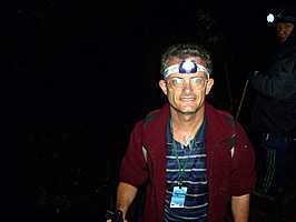
Introduction to today's journeyIt is not the mountain we conquer, but ourselves. - Edmund Hillary. Today's trek starts leaving Laban Rata at 2:00AM, from where we continue climbing the mountain in the darkness onto the dome between its peaks, and climbing to the mountain's highest summit in time for sunrise. After watching the spectacular sunrise, we return down the mountain to where we started yesterday. Today's JourneyDistance trekked today: 11.5 kilometres. Total distance trekked to date: 20.7 kilometres. Today's JourneyI WOKE up at midnight following a nightmare. I felt quite cold in the bunkroom, even in my warm sleeping bag. I had slept at an altitude far higher than I had ever been before, and was now about to climb to the summit of a seriously high mountain – the highest mountain I had ever seen. Nightmares are apparently a common phenomenon at high altitude. With two hours to go before breakfast, I rolled over and tried to get some more sleep. I never did go back to sleep. Richard woke up to his portable alarm just before two o’clock. He then woke up those of us who hadn’t already woken up. Bleary eyed, we got up and wrapped up warm in the very night cold air. People from other groups sharing our bunk room were stirring and getting up. It was a rather chaotic start to the day in the darkness at this totally unearthly hour. We left the bunkroom and staggered downstairs for breakfast. Not that I felt at all hungry. To my surprise the restaurant was packed full of climbers who were all wearing their mountain gear and had woolly hats on their heads. We found ourselves a table, and then stood in the rather long queue to get our plates and cover them with cooked breakfast food. I really didn’t feel hungry. I struggle to eat breakfast at the best of times in the most normal of mornings at sea level, so eating breakfast today was going to be a big challenge as my stomach had by now tightened into a knot of anticipation of the climb ahead and partly perhaps due to the effect of altitude. I sat down with the rest of the group and rather unenthusiastically ate the nicely cooked breakfast. Our guides Sapinggi and Lianty joined us. They both looked terribly enthusiastic to come and join us on our quest for the summit. The very thought of going so high during the night actually sickened me especially as I had seen how steep the terrain up there was when the cloud had cleared briefly yesterday afternoon. In fact I had never even done a night climb before. I went outside to the same balcony where I had viewed the sunset just eight hours ago. It was very cold out here with little to see. In front and below was a small constellation of lights. These were the lights of Kota Kinabalu appearing surprisingly close even though the city was ninety kilometres away. Then I looked up. The stars were phenomenally bright. I was used to the disappointment of only being able to see a handful of stars from where I lived in Brisbane. I had however seen some amazing views of the stars in New Zealand when I had been travelling in remote areas experiencing the crisp air of subzero temperatures on a clear night. The view from here topped them all. Being over three thousand metres above sea level meant that up here I was clear of all the thick grunge of dust, pollution, humidity and lights that pervade the lower altitudes. Here the sky was perfectly clear and the stars seemed so much brighter and closer than I had ever seen them before. I recalled reading the stories of astronauts telling about how amazing the stars appear from outer space. It obviously wasn’t that clear down here as there was still a lot of atmosphere to look through, but it was still an absolutely amazing spectacle looking across the Milky Way sweeping over the sky in all its glory. I returned inside the hut in time for Sapinggi to give us our final briefing. He started by congratulating us for getting this far up the mountain and for getting up so early in the morning. With a huge grin he told us this was where the serious fun begins. He told us just to go up at our own pace and they will help us out. There was absolutely no hurry to get to the top. It was pelan pelan. There will be a stairway up to the checkpoint at Sayat Sayat, where he will check us all in. From there we will need to follow the rope up to the summit. Once we reach the summit, we should find a place to sit just below the top, where we will be sheltered from the wind. At the top we will get extremely cold very quickly, so it is better to watch the sunrise from the shelter of the rocks just below the summit. That all sounded good and simple, all apart from the rope between Sayat Sayat and the summit. How much climbing was there? We got a group photo with my little camera before we were ready to leave in convoy with all the other people who had stayed the night and managed to get themselves out of bed for the challenge to reach the summit in time for sunrise. I had never seen so many insane people in my life. It was cold outside. It wasn’t bitterly cold, but cold enough not to want to stand around for any length of time. We all turned on our head lamps and performed a few warm up stretches for the long hike ahead. I was very nervous, having never done a night climb before, and having never been at this altitude before. A sickening feeling went through my stomach. There was quite a crowd outside the hut now, all getting ready to start climbing with their guides. Some groups had already left. If they go at a good pace, then they will have a long cold wait at the top for the sunrise. I double checked I had everything with me. The SLR camera had been packed into my day back. It would be too hazardous to do the summit climb carrying it around my neck as I had done yesterday. I had my small camera in my pocket ready to take pictures on the way up. At night the quality won’t be much different between the cameras, I’d have more success with the small camera, plus it will be a lot quicker. There was no time to afford with fiddling with a large camera up here.
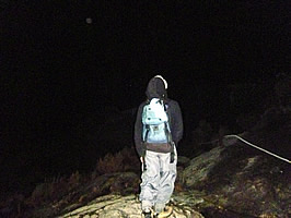
The starry sky above didn’t seem so bright now with all the head lamps turned on. I find stars are like glow worms. If you shine a light on them they go dim. If you leave them alone in the total darkness they shine bright. Stars are the same. Sapinggi led the way along a gravel path through thick scrubby undergrowth. The vegetation was covered in drops of water still wet from the rain of yesterday afternoon – that had only been a few hours ago. The path only lasted a couple of minutes though before stopping at the start of a wooden staircase. I started climbing the stairs, slowly following the boots of the person in front of me. Pelan pelan. This one was even steeper than any of the staircases I had climbed yesterday, and the stairs seemed to be suspended in mid-air. The stair cases clung to rocks on our right, and seemed quite high above the ground below us – a good metre or two. Once we were up one staircase, it abruptly turned right around a bluff to continue up the next suspended set of stairs. The sickness in my stomach was turning into nausea. Now what did I do with my nausea tablets? I think I had left them in my main pack at the bottom of the mountain. Drat. There’s nothing I can do about that now except to will myself to keep my breakfast in my stomach – the breakfast I didn’t want in the first place.
Everyone was very quiet as we shuffled single file as a slow moving row of lights all heading through the thinning forest towards the top. I couldn’t see very far in front of me as the staircase continued winding around bluffs and bush. I dared not look back as I was already dizzy from vertigo. It was scary enough negotiating each step from one wooden plank to the next one with the ground being at least a metre below me. One misplaced step and I’m history. We stopped occasionally. To my surprise I now felt rather warm, necessitating the unzipping of the front of my polar fleece top. Although the air was very cold, I was sweating under my clothes. Without any thermal shirt underneath, I didn’t want my tee shirt to get wet, especially in the chill of the summit. Fortunately there was no wind at all here, but I knew it would be a very different story at the top. A dull headache was starting to form now, but thankfully the nausea was starting to subside. The stairs suddenly stopped and I found myself walking on solid rock. The trees suddenly became very stunted and sparse. Looking ahead everyone had slowed down a little to form a short queue. Then I saw a rope heading across the face of a rock heading diagonally upwards. This must be the rope climb I had been dreading. I reached the rope and grabbed onto it, following the next person in front of me and sidling along heading up. The rope was actually a relief as I no longer had to make a conscious effort to maintain my balance unaided in the steep dark terrain. The rope felt cold to my hands. My gloves were still in my pockets, but now I was wishing I had them on. I sidled along the rope, edging my way along a narrow granite ridge just five centimetres wide under my boots. My cold knuckles began to scrape against the rough granite to the point they drew blood. Granite is a very hard abrasive rock to scrape ones knuckles against. It didn’t help with the rope constantly moving with all the people in front and behind me heading across the steep rock face. I climbed along the side of a worn pegmatite crevice in the rock. Then the rope turned around a large eyelet screwed into the rock. I pulled myself up and followed the rope now heading straight up the hill. I followed it up crossing over more bare rock. By now the forest had been reduced to small stunted trees, making it feel a lot more exposed up here than it had further below.
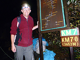
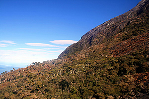
The rope climb suddenly ended and we were walking along granite rubble along the side of a gully. Beside the track was a marker like the ones we had seen yesterday. This one was at seven kilometres from the start of the track indicating an altitude of 3653 metres. This marked the limit of the forest. I had seen tree lines in New Zealand, but these were at a much lower altitude because New Zealand is in a cold temperate zone. There the bush line ranges from nine hundred metres above sea level in the lower South Island to about twelve hundred metres above sea level in the middle North Island. Here it was well over three and a half thousand metres.
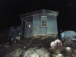
I looked ahead of me and saw amongst the row of headlamps a dim light that wasn’t moving. It was the light through a window up ahead. How strange it was to see a hut perched so high up the mountain. I continued walking up through the scrub towards the hut. It was the very small hut of Sayat Sayat perched on the top of a large rock, and there was someone inside. We entered a small gate beside the hut. The gate is locked in the late afternoon when the last climbers have come down, and gets unlocked at about one thirty in the morning unless the weather is bad. If the weather is bad, the gate remains locked preventing anyone from passing. We briefly waited at the gate while our guides Sapinggi and Lianty both registered their details. We were standing next to a large scrubby bush with white flowers. We passed through the gate where I could see a silhouette of a man with a dim light behind him. He checked my pass, made a quick note in his large notebook, and then waved me on to head up the mountain. It was official - I was deemed crazy enough to be worthy of a summit attempt here in the dead of night. The terrain changed dramatically following the short stop at Sayat Sayat. We were now climbing on bare rock with only the occasional patch of grass or other vegetation growing between the cracks. The white rope showed us the way up the steep rock. Looking above me I could see a very long row of lights. The headache and nausea that I had felt further down the mountain had completely gone by now. We continued ascending across the steep rocky face. Although the white rope was trailing along the ground beside us, it was not steep enough to necessitate holding onto it as had been the case earlier. Its function now was to guide us towards the summit still a long way ahead in the blackness of the night. The trees that had kept us company throughout the trek so far had disappeared and the only vegetation was grasses growing in the cracks in the rocks. The granite felt quite slippery from yesterday’s rain. Sapinggi who was now walking next to me told me not to step on the dark patches. Those were the wet areas where the water was seeping down the rock from yesterday’s rain. The lighter patches were dry providing a firmer and safer footing. It was getting very cold now, but not windy yet. The stars were still bright overhead, and I could see a line of head lights rising steeply ahead of me into the sky. The gradient of the mountain seemed to decrease as we gained altitude.
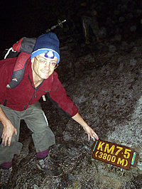
I recalled Richard telling us that we would pass two peaks before reaching the summit on top of the third peak. I had not seen any peaks yet, so knew there was a long way to go. Curiously I had not seen Richard since leaving Laban Rata, so I assumed he was at the back of the group. Finally I saw the 7.5 kilometre marker at 3800 metres above sea level. I stopped there to get my photo taken. I couldn’t see any of the rest of the group up here, but there were two guys from another group, and I took their photo and they took mine. For me this was another significant milestone, having ascended to an altitude higher than New Zealand’s highest mountain, and higher than Mount Fuji in Japan where both my brother and sister have climbed. I was apparently now higher than any of my family had been. At this altitude the air was starting to get rather thin, and my headache was beginning to come back, but only very mildly this time.
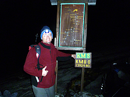
The ground remained flat and the steepness seemed to reduce as I continued ascending the mountain, passing the eight kilometre post at 3929 metres – just a hundred and twenty nine metres gain in altitude since the last post five hundred metres ago. At this point I still couldn’t see anyone else from my group. Had they gone on ahead or fallen behind? I suspected the latter. I had now caught up with the next group and passing the slower members. I didn’t know if any of the people immediately behind me were in my group. I wasn’t too worried though as our assistant guide, Lianty, was walking about three metres ahead of me. If I had separated too much from the rest of our group he would have helped me back to them. So long as one of the guides was near me, then there was nothing to worry about. The rope I was following was now no more than a guide leading the way up the now gentle slope. I looked further ahead along the rope and saw the stream of lights going straight up to what appeared to be a saddle just a few hundred metres ahead. At the saddle the lights seemed to head across to the left only to disappear in amongst what seemed to be huge boulders. It was hard to tell in the almost total darkness though. I had not seen either of the two peaks that Richard said I would pass before reaching the summit. How much further was there to go? The flat granite terrain suddenly gave way to huge boulders near the top of the broad saddle. There were a couple of people resting under the bottom boulders sheltering from the frigid wind that was now blowing across the saddle, but there was no way that I was going to stop. It was freezing up here and the wind chill was bitterly cold, not much above freezing now. Although this may not seem very cold, it felt extremely cold to me having just spent several days in the steamy humidity down at sea level now some four vertical kilometres below me where it would be about twenty seven degrees warmer given the six degrees per thousand metres rule. I pulled myself together and started scrambling up the boulders behind the people ahead of me. To my left I could just make out the black silhouette of a fairly large peak. It was either very large, or very close. Either way I couldn’t tell in this very poor light. I assumed this would be the first peak, so there was one more to pass before reaching the summit. I continued scrambling up the rocks, quickly losing my enthusiasm. The courage that had until now driven me towards the goal was starting to wane. It was quite steep and uneven climbing over the huge boulders. I had suddenly lost track of the people in front of me who had managed to scramble up a particularly steep section of rock. Unfortunately I had been remiss in not noting the direction they had taken. Now I found myself not knowing where to go and briefly thought that perhaps this was beyond my capability. Will I have to turn back and head back down to the safety of the lush warm jungle. Had I reached my utter limit? Then someone on the rock above me in the blackness told saying to go right. I was a little disoriented from the altitude by now but I realised he was talking to me, so I followed his direction and turned right. Initially I didn’t even recall who he was, but a little later I realised he was Lianty, the assistant guide who had been quietly walking up the mountain with me – whether we were at the front of the group or at the back, I didn’t know. I hadn’t seen anyone else in our group for about half an hour now and guessed everyone else would have gone on ahead. That being the case I would have to pick up some speed to catch up to them. Within two minutes I was above the little cliff that had nearly terminated my quest for the summit. I had received no physical injury at all, but the short section of rock had nearly broken me mentally. I looked further along the rocky slope I was climbing. There were lights ahead of me, but there seemed to be no end in sight. There was no sign of a second peak, and certainly no sign of the summit. I could see the steep slope rising a bit higher, then disappear most likely into a dip which would no doubt lead to more rises to the summit. Now I was experiencing the terrible illusion where the more steps I took, the further I was away from the summit – what I call the retreating summit illusion. Now this was by no means the first time I had experienced this. I had first encountered the retreating summit illusion as a teenager back in 1988 whilst climbing a small mountain close to the commune where I lived at the time. The hill was aptly named Sugarloaf and it was very steep. I had climbed the back of it with two others, and upon seeing the summit I had decided to go up whilst they rested with showing no interest in summiting the hill. Sadly I reached what I thought was the summit, and found it was no more than the end of a particularly steep section and there was more distance to go. That happened a second time but third time I was lucky and reached the summit. I suspected the same thing was happening here. I was locked in the fear of climbing something unfamiliar and not knowing how much further there was to go. I had not seen any markers since the 3929 metre mark, and figured there must be at least one more before the summit. Looking up I couldn’t see much apart from a few lights slowly negotiating their way up the precarious pile of boulders in this remote spot now some four kilometres in the sky in the bitterly cold wind. I felt ready to give up, but having come this far, failure was not an option. Somehow I managed to extract from the thin frigid night air the last burst of strength to give me the willpower to do whatever it would take to reach the summit. Once more I looked up and this time saw two small signs ahead of me. They looked very familiar from photos I had previously seen of the area. Then I realised this was the summit. I was now just ten metres short of my epic conquest!
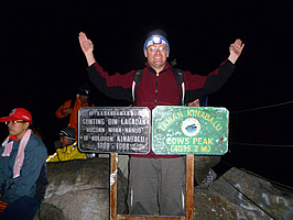
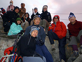
I glanced to my right where a small patch of the eastern sky was beginning to go orange breaking what had been a long night. The sun will be rising shortly. Thank goodness because it was so bitterly cold up here. The wind was piercing through my thermal top and now I was regretting having left my thermal underwear at home. It hadn't occurred to me I'd need that in Borneo. I climbed the remaining few metres reaching the summit with relative ease. I handed over my camera to Lianty who led me. He took a couple of photos of me before a couple of others in our group arrived. It was only then I realised I had actually been the first in our group to arrive. I collected my camera and went a couple of steps down the mountain to the shelter of some rocks. The others all arrived and had their photos taken before they joined me to watch the sunrise.
When everyone had arrived with Sapinggi at the rear, he asked who had reached the top first, and my guide Lianty pointed to me. Everyone cheered. It was awesome having been the first in the group to arrive, although my main motivation was thinking that the others had all gone on ahead. However, as Sapinggi had said the other night, it wasn’t a race, it was a matter of everyone reaching the summit, and we had all successfully achieved that – or had we?
Where was Richard? He had been at the back of the group when we had left Laban Rata, but I had assumed he was at the back with some of the others. He was noticeably missing now. We all wondered where he was, but our guides didn’t seem at all concerned by his absence. It was a bit sad though that he wasn’t up here celebrating with us given all the encouragement he had provided us over the past few days. Then again he has been up here many times before the novelty would have well and truly worn off.
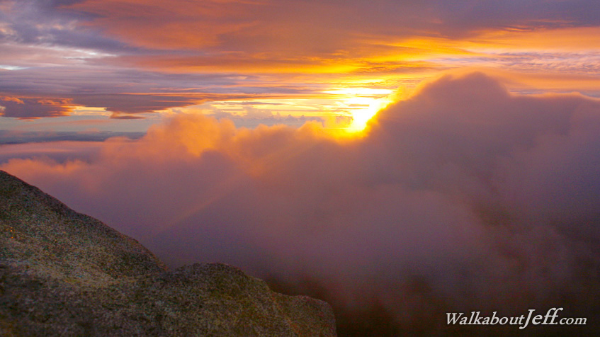
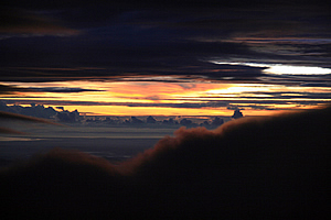
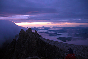
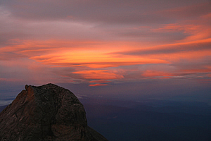
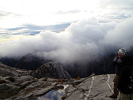
The eastern sky continued to lighten as the sun rose above the distant horizon. For the first time I now realised I was sitting just centimetres away from a rather flimsy fence with three thin wires running between the metal stakes. The fence was all that stood between me and a vertical drop into an eighteen hundred metre deep chasm that tore the mountain in half. This chasm separated us from a ridge of jagged peaks which stood above a large razorback of cloud. The level of the cloud was just below the distant horizon.
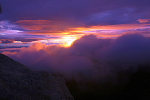
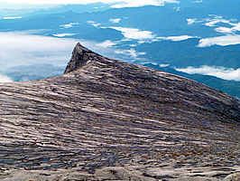
The rising orange sun poked through a gap between two humps of razor back clouds, under some purple alto cumulus clouds just a couple of hundred metres above us and appearing strangely low. The sun highlighted the purple clouds with fiery oranges and yellows. The distant horizon was glowing a fiery yellow colour in the thin band between the clouds. Looking south, I could see the naked sooty grey rocks we had scrambled over, down to the flat rock surface below. I could see the large peak I had seen, the bare rock rising unnaturally above the dome. Beyond that to the left was a much smaller peak sticking erect like a horn. This was the famous south peak – the one I had missed. Further around to the right, on the other side of the chasm stood several mysterious crags shrouded by mist.
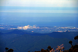
Looking directly past South Peak, I could see the mountains below. The tops of the rounded black mountains were standing above the woolly purple clouds occupying the valleys between them. Some of these mountains were over two kilometres high, and had seemed very tall from Manukan Island a few days ago, but they were now hardly ripples in the purple grey predawn forest so far below. I looked out beyond the mountains to see the lights of Kota Kinabalu ninety kilometres away seeming to be surprisingly close. It was still dark down there, and will be a while before they will see the sun rise. Beyond Kota Kinabalu was the vast purple grey ocean extending to the horizon some two hundred and thirty kilometres away.
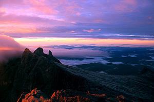
Here on the bare rocky highest summit of Borneo, the sun had already risen, but the faint illuminating rays of the sun did little to warm us up in these frigid conditions. Most locals would freeze to death up here, but not Sapinggi or the other guides. They were tough in their element with their deeply weathered faces. Sapinggi in particular has lost count of the number of times he has stood here on the summit, but I guessed he had stood here to watch some three thousand sunrises since he started leading groups up the mountain in 1976. That was the year when I first started school.
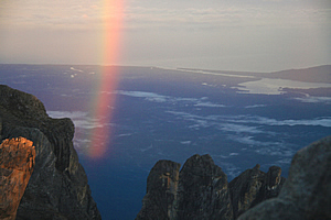
As for me, this was my first time up here, and all the hiking I had done in New Zealand had done nothing to prepare me for the coldness of the exposed summit. I had never summited a mountain in the early morning to watch the sunrise. All my summits before today were achieved during the warmth of the middle of the day. Looking out to the west, the wispy cloud apparitions beyond the mountain turned a vibrant but cold orange colour as the sun continued to break its way through the cloud behind me. There were two small peaks nearby, and next to one of them was a rainbow. Now I’ve seen many rainbows in my time, but they were always arches starting from the ground extending overhead. This rainbow was to its side. The peak stopped it from being a complete circle, but it was perfect from bottom to top on the right hand side. As the sun intensified the rainbow brightened and lengthened.
The peak surrounded by the rainbow was St John’s peak, famous for the legend of the Chinese Widow – or Cina Balu, one of the two possible origins of the name of the mountain. I recalled Sapinggi telling us the other night this large peak was the petrified eternal incarnation of the widow who frequented the mountain to look for long lost Chinese husband. Just as Sapinggi said in the telling of the legend, the peak faces the South China Sea which we could see far below us. The peak represented the widow cast eternally in stone forever awaiting her husband to return from China. Today she was showing off her beauty with the rainbow on its side beside her like the flowing robes of a brightly coloured gown flapping in the wind. But that was nothing compared to an even more amazing phenomenon starting to unveil.
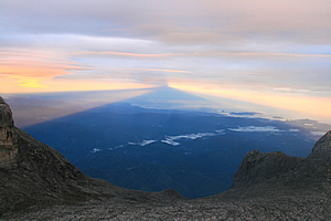
A vast blue shadow was now forming beside the rainbow. This was the shadow of the mountain extending over two hundred kilometres into the distance, pointing towards the west. The spectacle was breathtaking. Here I was having conquered a mountain far higher than any in Australasia and viewing this amazing alien world so unlike anything I had ever seen before, and here I was sharing it with a group of newfound friends, all huddled together in near freezing conditions on top of this legendary mountain. No wonder the locals considered this to be such a revered place where the spirits of the dead would venture to. Having successfully conquered the summit, we slowly descended the rocks which we had struggled up in total darkness less than half an hour ago. I started falling a little behind the others, thinking that I was going to slow everyone else down. Now that it was light, I could now see the rocks that I was climbing down. It was desolate here, with just a few yellow tufts of grass growing in the fractured fissures in the rocks. I was amazed that anything could survive up here in this alpine desert exposed to the harshest of elements.
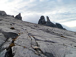
Finally I reached the bottom of the boulders back on top of the dome. The rope started here, so I followed it back towards Sayat Sayat now unseen over the edge of huge grey dome. There was an irregular patchwork of white pegmatite amongst the grey granite, and there were huge long cracks in the rock, probably as a result of the enormous stresses of the mountain continuing to rise five millimetres per year as it had done over the past ten million years since the batholith solidified deep in the Earth’s crust. The stresses showed some folding of the rock, giving away clues as to the directions the magma was flowing when this part of the mountain was solidified.
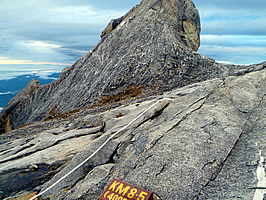
Water accumulated into some of the cracks forming dark cold ponds. The cracks that weren’t flooded were abundant with tufts of grass similar to tussock. The clouds surrounding the mountain were now lifting from the deep valleys in which they had slumbered overnight. The cloud formations now looked like a giant tsunami that had enveloped the valleys. No doubt it would be very hot and humid in amongst them over three vertical kilometres below me. I spotted a marker which that I had missed on the way up. This was the 8.5KM 4001M marker. This was the one I had missed coming up in the darkness of the night. I mustn’t have been looking in the right direction when I passed it.
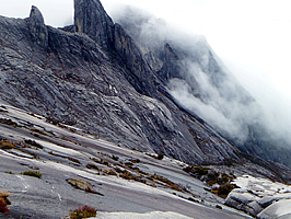
Heading further down the dome of the mountain I could see why Sapinggi had advised us to keep to the ropes. Just ten metres to the left was the edge of the eighteen hundred metre high cliff marking a glacial valley that had carved out the deep chasm passing the summit in ice ages past. This was called Low’s Gully, named after the first explorer who had successfully reached the dome. Although I was right at the edge of the chasm, this was one of the least explored and most inhospitable places on Earth. In 1994 two British Army officers led a party of ten adventurers into the gully. The party split in two. Five members were trapped for sixteen days and did not eat for the final five days before being rescued at great expense by the RAFF and the Malaysian army. The breakaway party of five successfully completed the world’s first descent of the gully in three days, but had returned to intense criticism.
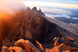
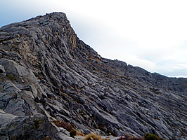
The ice that had formed the glacier during the ice ages had also covered the dome of the mountain, eroding all of it down apart from the sharp peaks which were somehow spared due to lack of ice stresses there. Small tufts of grass grew in the exposed rock cracks, barely able to survive in these severe conditions. Cloud blew over the top of the ridge, with the thick fingers of the crags ahead of us now piercing them like fingers running through water. There was something very mysterious about these crags. They would be extremely difficult to climb requiring special equipment. The steep mitre shaped crags stood tall towering over us like sentinels overseeing the mountain, guiding the ghosts of the deceased who had completed the pilgrimage to whatever afterlife they believed in here in this part of the world.
Even the main summit of Low’s Peak stood like a petrified wave that was just about to barrel. The stratification definitely bent outwards almost at the summit. The summit though was very plain in its triangular shape compared to the other crags which stood contorted around the edges of the ravine. It was a strange feeling walking in the midst of the secretive yellow mists of departing souls. The mist glided past the sentinel peaks with a seriousness questioning why the living would dwell here amongst the dead. Here two worlds clashed. We seemed to be in the wrong place interfering with the spirits of the people who had arrived here as their final earthly destination on their way to the afterlife in some other world not far from here.
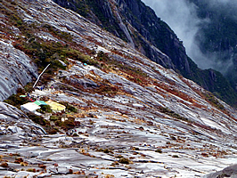
Sapinggi walked with me at the back of the group as the dome became steeper and steeper. I could now see the tiny speck of Laban Rata far below us, and the bottom of the mountain even further below us becoming captured in the cloud now rising from the valleys of their night slumber. A minute later Laban Rata had disappeared in the cloud below, and once more we were alone up here on the mysterious dome. The surreptitious hut of Sayat Sayat now appeared down the steep mountain just where the bare grey dome met the dark green stunted foliage of the alpine forest. It was off to the left, and fortunately the route turned off to take a more moderate approach following the cracks in the surface. It was still a little steep, but nothing compared to the chasm that seemed to be opening up further below. The hut didn’t seem anywhere near as ominous as it did yesterday from Laban Rata. It was quite a different view here from above where I could see the way down to it.
The roped route gradually steepened as the dome dropped towards Sayat Sayat. Finally we crossed a small stream and walked along a flat trail across boulders for a minute before reaching the checkpoint at Sayat Sayat, where I was checked out of the haunted dome of the mountain. The others were already on the other side of the hut there resting having all arrived only a minute or two before me. Nadia seemed very happy to have run down the last section of track. Perhaps she was going to be fast getting down to the bottom of the mountain and therefore I would be the last one down. I now saw the ragged wind swept bonsai scrub at the tree line. I had never seen such a high altitude tree line before up here at three thousand six hundred metres.
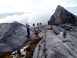
There were actually three small huts here, all solidly built to withstand the extreme weather encountered in this desolate place. The main hut of Sayat Sayat looked like a large steel drum upended with a steel conical roof at a low pitch. The other huts were probably storage sheds or perhaps even sleeping quarters for those who worked up here in Borneo’s highest office. Looking up from here most of the mysterious outcrop peaks were not so obvious any more now being quite a long way above us, but there was still a clear view up to the top of the dome. It was a little slow coming down the cliff face single file in amongst several other groups coming down the mountain. Under the bright light of daylight it wasn’t so daunting. In fact the section of rope was just a small seam that we needed to sidle across. There were plenty of people in front of me keeping the pace slow, which I found perfectly manageable apart from the rope once more moving a lot.
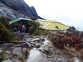
Upon reaching the bottom of the seam, we entered the forest down the steep wooden stairway we had climbed just a couple of hours ago. The steps were quite often high above the ground, and each wooden plank used to make the steps were quite narrow leaving a rather large gap that would have been very easy to fall through and break your legs. As I walked down the steps I wondered how many legs have been broken here. Fortunately I picked up a slow rhythm and managed to make reasonable progress with no problem. It was a long climb down the steep winding steps. The staircase negotiated its way around the precarious little bluffs we had just been able to make out in the darkness of the small hours of the morning a few hours ago. It was a very nice welcome relief to finally see the Laban Rata hut through a rare clearing in the forest below me just a couple of hundred metres ahead. I continued following the stairs downwards. The gaps between the stairs and the ground below were frightening, and the bush was low, but minutes later I reached the bottom of the stairs where a metal gate was open. I assumed when the mountain is closed the gate is shut. I had not seen this in the darkness of the night, but obviously if the staff decided the weather conditions were too dangerous to climb the mountain, then they would simply lock the gate to the only way up. From here the track was a fine gravel surface down a very gradual slope passing some of the huts surrounding the main one. Then I reached the entrance to Laban Rata, a big relief. Looking back up the mountain I was amazed to see the sky had mostly cleared. Where had the clouds gone? The surrounding terrain didn’t seem so ominous now that the bright sun was shining on it. It seemed to have lost some of its mysteriousness. For once there would be a pretty clear view of the mountain from those below whether they were setting off from the bottom, or were way over in Kota Kinabalu. There were still some clouds hanging over the summit dome, the eternal mists surrounding the ghostly petrified peaks that had inspired the legends. It was a relief to be inside the hut with the others from my group. Most had already arrived and were sitting at the table we had sat at yesterday afternoon. There were a couple of others behind me, who were just entering the hut now. Nadia was still coming down with Sapinggi and Lianty. Exhilarated, I joined the group at the table. Richard was there amongst the rest of the group who had already arrived. It turned out that Richard had turned back once we had reached the start of the stairs within two minutes of the hut. He was very tired, so he had gone back to bed. He admitted he usually does that when he leads a group up the mountain. He has been to the summit a few times in earlier trips, and that was enough for him. So far as he was concerned, from this point on we are in Sapinggi’s hands. What a shame he had not been at the summit to celebrate with us, but we accepted his excuse.
Food was being laid out on the serving tables now. This must be second breakfast, and we were definitely hungry now having hiked for a good five hours. The nausea I had felt climbing up between here and Sayat Sayat was a long forgotten memory by now, and now I was very hungry. We all joined the queue to serve ourselves a very nice cooked breakfast. Once back at our table, we reminisced about our stories of getting to the top as we ate second breakfast. Suzanne had cried most of the way up in the cold conditions in the small hours of the morning. About half an hour later Nadia arrived with Sapinggi. Everyone was now back, so we celebrated the conquest of the summit over breakfast before heading back up to our room to pack up and give our small bags to the porters to pack and take down the mountain.
Once everything was packed I returned to the dining hall to wait for the others. Sapinggi arrived about a minute later and said most of the others had already left, and I should start heading down now. Apparently they had left out the side entrance and gone down the spiral staircase. I started the long walk down the mountain in the clear sunlight. I wasn’t sure who had left and who were still up there. I really don’t like downhill, and I wasn’t looking forward to the rabble of uneven boulders going down the ultramafic zone. As expected, the pace was rather slow going down the boulders, but I took it one step at a time. Richard quickly passed me at a surprisingly high speed. He seemed keen to catch up to anyone at the front. I continued plodding along until Suzanne, Casper and Tobias all passed me near the end of the ultramafic zone.
Once I reached the proper staircase at the bottom of the ultramafic zone, I managed to pick up some speed, and yet still enjoy the scenery and get down in one piece. The sun was shining brightly over the trees now, so it wasn’t mysteriously eerie like it had been yesterday morning when the mountain had been surrounded in a cocoon of mist. The forest above my head grew taller and thicker as I lost altitude. The walk became quite a lonely downhill journey for a while but I eventually saw another group ahead of me. I gradually caught up and overtook them at the rest area at 2518 metres. Now I was back into the altitudes that I had climbed before, but 2518 metres suddenly felt very low compared with where I had just been. As I continued the descent, I felt the atmosphere getting thicker and warmer as I lost altitude, and it was great to have the markers at every five hundred metres showing how much further there was to go. One young local lad wearing cheap running shoes suddenly sprinted past me. He moved at an incredibly fast speed briefly acknowledging me as he went. One small slip could be fatal for him at this speed. I wondered if any of these porters and workers up here ever did fall and get seriously injured or killed. I was about one and a half kilometres from the end of the track when I poked my walking pole into the ground to help me down one of the countless thousands of steep steps. Suddenly the round mud stop at the bottom of my walking pole popped off. I stopped to search for it, but it had popped off with such speed that I couldn’t find it. It had flown off into the thick jungle undergrowth. So if you are ever climbing Mount Kinabalu along the main route, remember me when you pass the one and a half kilometre mark, because somewhere up there the little round black mud stop at the end of my walking pole is still sitting in the thick undergrowth to this day. I continued following the steep natural staircase path which eventually levelled out to a relatively gradual slope. What a relief – I must have come down about six thousand steps today. With just a short descent to go I was nearly there with just one kilometre to go. The track remained fairly level until almost the half kilometre mark before steeply dropping down to the small waterfall. Here the track was quite wet no doubt from all the rain that had fallen here yesterday afternoon while we were further up the mountain above the worst of the weather. Once past the waterfall the track started to go uphill to the hut at Timpohon Gate.
Thank goodness I made it to the bottom. I saw Suzanne there. She had missed the last shuttle which everyone else seemed to have caught and had been waiting there for twenty minutes. Another van pulled up and we climbed on board and headed back down the road to the large dining hall below the information centre where we had breakfast yesterday morning. Suzanne and I staggered down the stone stairs and entered the dining hall where we had breakfast just yesterday morning. I couldn’t believe that only thirty hours had passed since then. So much had happened in such a short time. It was quite hot down here and we were all hungry. Richard phoned Sapinggi (amazingly mobile phones worked up the mountain!) and he advised that Nadia was still about three quarters of an hour from the bottom, so the rest of us started lunch. It was a nice buffet meal which we shared with several other groups we had hiked with, including the fit group that I had actually overtaken on the way down. It was such a relief to be finished the climb. The rest of the trip was going to be very relaxing. We shared our experiences of what it had been like up at the summit as we ate lunch. It was there I again raised the question whether anyone ever dies up the mountain. Having had a lot of experience with this in New Zealand, where it hit home once whilst travelling with a police officer who had personally picked up sixteen bodies off the slopes of Mount Ngauruhoe. It seemed to be quite a taboo subject here, but now we were off the mountain, Richard finally told the story of a tour leader in the same company who had taken a group up, including two teenage children. Coming down the dome of the mountain had become very misty, and the two children had lost the rope. They continued walking for a few more minutes before they realised they were lost. They decided to sit down and get their bearings. The boy was cold, so the girl gave him her jacket to wear whilst she would walk back towards the rope and call for help. She left him there on his own.
Ten minutes later the cloud suddenly cleared around the boy and some passers by found him. He was taken safely back to Laban Rata with nothing more than mild hypothermia. The girl was discovered a couple of days later, her lifeless body lying on the granite face a long way from the trail. When she had left the boy to get help, she had gone completely the wrong way, and with inadequate clothing she died from hypothermia – not the expected cause of a death when travelling the equatorial tropics. Obviously the tour leader was distraught about losing one of his tourists on his watch. The hardest part for him would have been breaking the news to the family. He would have to live with that for the rest of his life. He resigned as a tour leader soon afterwards. There had been a number of other deaths on the mountain over the years. No matter what safety precautions and briefings you go through, there is no way of guaranteeing your safety up such high mountains. They are very dangerous. I had climbed Kinabalu perfectly aware of these dangers, and had been prepared to accept the risks. I’m not sure though if some of the others in the group who had little mountain experience had realised just how dangerous it can get up there. It was nearly an hour later when Nadia finally arrived with Sapinggi. We let them have their lunch as we continued relaxing at the table. |
||||||||||||||||||||||||||||||||||||||||||||||||||||||||||||||||
|
||||||||||||||||||||||||||||||||||||||||||||||||||||||||||||||||